 IMAS Metadata Catalogue
Environmental Management
Type of resources
Topics
Keywords
Contact for the resource
Provided by
Years
-
This dataset provides mapping of water bodies and wetland regional ecosystems at 1:100,000 scale across Queensland.
-
This dataset displays the reefs and shoals within Queensland maritime waters. Names have been sourced from numerous locations and attributes within the data describe the source of the names. Name sources include but not limited to: - Queensland Place Names Database - Great Barrier Reef Base Mapping - Geoscience Australia 1:100000 Topographic Mapping
-
This record provides an overview of the scope and research data outputs of the NESP Marine Biodiversity Hub Synthesis Study "Interpreting pressure profiles". For specific data outputs from this project, please see child records associated with this metadata. -------------------- This project has two objectives: (i) provide a spatial explicit analysis of the relative risks posed to marine conservation values, as defined by the natural values hierarchy of Parks Australia's Monitoring, Evaluation, Reporting and Improvement (MERI) framework, by pressures that operate within Australia's Exclusive Economic Zone and state/territory waters (a "hotspot" analysis); and, (ii) provide a proof of concept of an adaptive, probabilistic assessment of the cumulative risks posed to these values, in a region determined to support the Parks Australia MERI project D7, in a manner that is consistent with the seascape-scale cumulative assessment described in the "Guidelines for analysis of cumulative impacts and risks to the Great Barrier Reef". Planned Outputs • National hotspot maps of risks posed to marine conservation values • Probabilistic assessment (written) of cumulative risks
-
This polygon spatial dataset describes the benthic habitats likely to occur in marine environments around Gunn Point Peninsula and informs the desktop assessment of the marine biodiversity values for the region. The benthic habitats are inferred from existing information but in most cases require further data collection to validate and refine. Habitat modelling forms the basis of benthic community value assessment for Shoal Bay (Galaiduk et al. 2019). The accompanying report Marine and Coastal Biodiversity Assessment of the Gunn Point Area (2020) forms part of the Mapping the Future Project - Gunn Point. This project has identified land capability, water availability and biodiversity values to support land planning and inform development potential over the Gunn Point area. Reports and maps can be viewed from the webpage: denr.nt.gov.au/land-resource-management/development-opportunities - Development Potential of the Gunn Point Area (2020) - Biodiversity Assessment of the Gunn Point Area (2020) - Groundwater Resources of the Gunn Point Area (2020) - Marine and Coastal Biodiversity Assessment of the Gunn Point Area (2020) - Soil and Land Resources of the Gunn Point Area (2020) - Soil and Land Suitability Assessment for Irrigated Agriculture in the Gunn Point Area (2017) - Vegetation Communities of the Gunn Point Area (2020)
-
The GBR10 benthic habitat type map is the output of a modelling process that combines satellite imagery and other environmental attributes like water depth, slope and wave climate, along with known occurrences of benthic habitat type. The occurrences of benthic habitat type were derived through machine learning applied to geolocated photos of the benthos (>100,000 photos) that were collected along reef flats and reef slopes at various offshore shallow reefs (~100 reefs). The modelling process involves taking those occurrences of benthic habitat at known locations (training data) and using a machine learning model to build a relationship between benthic habitat type and the underlying data layers (imagery, depth, slope, waves). Because the data layers cover the whole Great Barrier Reef, a prediction is then able to be made for benthic habitat across the whole Great Barrier Reef as well. Contextual editing was then used to make changes to the map, based on a set of geomorphology- and ecology-based rules, such as what environment a class can occur in and what classes are able to neighbour each other (object-based rulesets). This map covers the “offshore” or “mid and outer-shelf” reefs of the Great Barrier Reef Marine Park. Some of the occurrences of benthic habitat type are withheld from the process, and used to check how well the mapping performed at the end (validation). The mapping was carried out by the Remote Sensing Research Centre at the University of Queensland. The scientific method for generating the benthic habitat map can be briefly described as: 1. Ingestion of Sentinel-2 satellite image data, bathymetry and wave climate data derived from Sentinel-2 image data, and various additional derived environmental covariates into Google Earth Engine 2. Stacking of the input data sources into a model-ready environment 3. Running a segmentation routine to create image objects 4. Fitting a supervised machine learning model (e.g. random forest) to known occurrences in order to classify segments into benthic classes 5. Application of object based rules using a range of colour, shape texture and relationship rules to modify the class attribution 6. Validation of mapping accuracy and performance This is an snapshot of the GBR10 benthic dataset taken on Jan 2023 for the Seamap Australia project from the GBRMP Reef Knowledge System (https://reefiq.gbrmpa.gov.au/ReefKnowledgeSystem), see also https://gbrmpa.maps.arcgis.com/home/item.html?id=492a87d95e8243728486718e7aed02a8. An updated version of the data may be available from the source provider.
-
Habitats serve a variety of functions on the North West Shelf (NWS). They support the life history stages of a diverse suite of tropical species including commercially harvested ones. In addition to natural disturbance regimes, habitats are altered in response to the sectoral uses, which in turn affects the distribution and life histories of species. Habitats thus serve as the nexus linking species with uses and natural disturbance, and different habitats serve different purposes at various stages of the life history of a species. A detailed understanding of habitats, at least at the structural level, is thus a prerequisite for a more comprehensive understanding of ecological structure and functions on the North West Shelf. This component of the North West Shelf Joint Environmental Management Study (NWSJEMS) aimed to collate and integrate data on habitats for the region of the North West Shelf extending from North West Cape to Port Hedland and from the coast to the 200 m isobath. The three main activities of the study were: Development of an integrated collection of information on habitats of the North West Shelf, including expert information; Application of the CSIRO Habitat Classification Framework to the data to determine the spatial nesting and structuring of habitat units on the North West Shelf; and Provision of the habitat structure classification for input into other models developed within NWSJEMS. This record describes data of key benthic marine ecosystems and habitats. These maps and descriptions of their component attributes were designed to assist the process modelling of the ecosystem and impacts of uses, as well as directly supporting planning and management by Western Australian agencies and industries.
-
This record provides an overview of the scope and research data outputs of the NESP Marine Biodiversity Hub Emerging Priorities project "Assessing the effectiveness of waste management in reducing the levels of plastics entering Australia’s marine environment". For specific data outputs from this project, please see child records associated with this metadata. -------------------- This project will contribute to better understanding where to target investment in abatement measures by providing information on the extent of the leakage of plastic materials into the marine environment, where the greatest leakages are and in what quantity, and what form they take (e.g. plastic bags, packaging, takeaway containers). It will also identify what type of facilities, policies and outreach strategies governments (state and local) have in place and undertake an assessment of their effectiveness. The objectives of this project are to: 1. Investigate the relationship between plastic debris in the marine environment and litter data from nearby sites; 2. Determine whether there are identifiable pathways through which plastic debris moves into the marine environment; 3. Investigate whether particular investments in facilities, policies or outreach are effective in reducing plastic debris on coasts and in oceans and where investment should be directed in the future; and 4. Initiate an internal department workshop to socialise the outcomes of the research across the relevant arms of the department, including staff involved in approvals, waste, protected species, and parks, and explore the utility of existing data to address the Department’s needs, including those arising from the TAP and the Senate Inquiry. Planned Outputs • A written report and plain English summary for use by state, territory and local governments, which: - Synthesises existing knowledge on the relationship between debris in the marine environment and litter data from nearby sites, the types of litter and the pathways through which litter moves into the marine environment. - Summarises existing coastal debris/litter survey methodologies with discussion of applications of each. • A list of the activities and programs associated with plastic waste reduction (including facilities, policies and outreach), • A publically accessible analysis and summary of different survey methods aiming to reduce debris inputs to the marine environment. - The cost of the activities and programs - Ranking of activities and programs regarding their effectiveness in reducing plastic waste in the marine environment. • Conclusions on where marine debris hot spots are in Australia’s marine environment and effective mitigation strategies. • Recommendations on where more information (scientific, policy, infrastructure, community engagement) is required to obtain a better understanding of the problem and possible solutions. This may include identifying knowledge gaps and needs for further analysis
-
This project used marine benthic imagery and fine-scale oceanographic data to refine existing models of the contemporary circumpolar distribution of Antarctic benthic biodiversity, and used oceanographic models developed in the ACEAS program to generate spatial predictions of the distribution of various aspects on benthic biodiversity and blue carbon under future climate scenarios. ***Access to data is currently embargoed, to be made available ~June 2026***
-
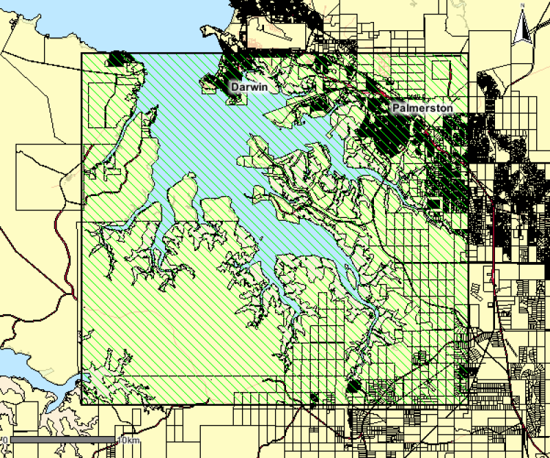
This polygon spatial dataset describes the mangrove communities for Darwin Harbour and its environs and was surveyed at a mapping scale of 1:25 000. The associated report notes an area of approximately 20,400 hectares of mangroves in Darwin Harbour and describes ten main mangrove associations or communities. The data provides a basis for identifying the extent and distribution of mangrove communities for Darwin Harbour and its environs.
-
This record provides an overview of the scope and research output of the NESP Marine Biodiversity Hub project "Analysis and elicitation to support State of the Environment reporting for the full spectrum of data availability". No data outputs were generated by this project. -------------------- The availability and quality of observation data that may be used to support State of the Environment reporting lies on a spectrum from: (i) high quality (e.g. Reef Life Survey, Long term reef monitoring programme, Temperate Reef Monitoring programme, state-based MPA monitoring programmes); (ii) moderate quality (e.g. continuous plankton recorder, occasional by catch surveys); (iii) low quality (anecdotal information) to (iv) expert beliefs but no empirical observations. We currently lack a principled process for utilising and merging data of varying quality and from different sources to form a national perspective to support State of the Environment reporting. The key unifying principle to support such a process is the extent to which the available data is representative of the environmental asset in question. As the extent to which the empirical observations accurately represent the state of the asset in both space and time diminishes, so the reliance on expert opinion increases, to the limit where the only available information is expert opinion. This project will provide an over-arching framework to consider these issues, develop practical protocols for blending different data streams with or without experts’ judgement as appropriate, and thereby provide a foundation for improving State of Environment reporting for all types of data sources, from high to low quality. It will do this by developing and applying protocols to support development of the marine chapter of SoE 2106. This currently being developed within a separate CSIRO funded project. The project will use the experience of developing this chapter to make recommendations about appropriate methodologies for future environmental reporting. Importantly the statistical approach and analysis principles will be consistent regardless of the amount or quality of the information available. As a result the framework and analysis methods will remain relevant, even as the quality and quantity of environmental data at the department’s disposal changes. This will provide the consistency of analysis and reporting that is essential to SoE. Expected Outcomes • The provision of two or three examples that demonstrate a unified approach to the use of expert opinion in SoE reporting. These examples will be identified in close collaboration with the Department and will be developed in time to support the marine chapter of 2016 State of the Environment report, contingent on the availability of resources in the second year of the project and timely interaction with the department. • Assessments of the status and trends of environmental assets in the State of the Environment report will be based on a principled and statistically defensible process that can merges and utilises data from all sources including expert opinion.