 IMAS Metadata Catalogue
2011
Type of resources
Topics
Keywords
Contact for the resource
Provided by
Years
-
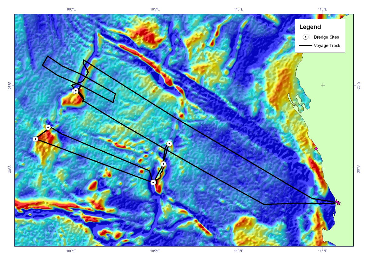
Dredge rocks were recovered on scientific voyage SS2011_06 on the MNF RV Southern Surveyor, from the Perth Abyssal Plain, offshore Western Australia. Continental rocks (gneiss, granite, sandstone) were dredged from both the Batavia Knoll and the Gulden Draak Ridge (dredge sites 1, 2, and 3). A small amount of high weathered basalt was recovered from the Gulden Draak Ridge (dredge site 4). Three successful dredges were undertaken along the Dirck Hartog Ridge recovering predominantly gabbro (dredge 5) and basalts (dredge sites 6 and 7).
-
Webcam established at North Bay, Tasmania, early 2010 as a deterrent for poaching translocated lobsters. Webcam is sited on the southern end of the site facing north. Pictures are taken every 15 minutes and transmitted to a server where they can be accessed remotely by users. As at Novenber 2011, pictures are still being taken and archived.
-
Rock Platforms on Tasmania's east coast, Flinders Island, and the north coast as far west as Port Sorell, were surveyed between December 1995 and September 1996. At each of 51 sites two transects were sampled using quadrats. All animals and plants were counted, or in the case of sessile species, their cover was estimated.
-
By utilising targeted microprobe technology, the analysis of elements incorporated within the hard bio-mineralised structures of marine organisms has provided unique insights into the population biology of many species. As hard structures grow, elements from surrounding waters are incorporated effectively providing a natural ‘tag’ that is often unique to the animal’s particular location or habitat. The spatial distribution of elements within octopus stylets was investigated, using the nuclear microprobe, to assess their potential for determining dispersal and population structure in octopus populations. This was investigated in adult Octopus pallidus sourced from a commercial fishery in Tasmania.
-
The main aim of this research program was to determine the potential for reducing the density of urchins to encourage the return of seaweeds and an improvement in urchin roe quality and quantity from remaining urchins. Tasmanian Sea Urchin Developments used two widely-separated sub-tidal experimental lease areas. One of these areas was at Meredith Point, on the east coast, and the other at Hope Island, on the south coast. Both sites had been subject to some overgrazing by urchins. At Meredith Point, the study area was divided into plots containing urchins at three densities: artificially enhanced, continually harvested and control (undisturbed). At Hope Island, controlled clearings of urchins and limpets from barrens areas were conducted. Recovery of vegetation was monitored as well as urchin roe quality and quantity. The data represented by this record was collected at Hope Island, and includes results from an inital survey collected at the site before the main study commenced.
-
These data were collected on the RV L'Astrolabe (platform code: FHZI) from 22/01/2008 to 27/01/2008 on a trip from Dumont D'Urville to Hobart. Maximum photochemical efficiency of photosystem II (PSII), also called maximum quantum yield of PSII (Fv/Fm), has become one of the most widely utilized fluorescence parameters in phytoplankton research. It represents the potential photochemical efficiency, which is the probability that the light energy captured by the photosynthetic apparatus is being utilized as photochemistry. Fv/Fm has been shown to have an instant response to variations in physical and chemical properties and is interpreted as a diagnostic of the overall health or competence of phytoplankton. Together with the absorption cross section area of PSII and chlorophyll concentration, it can be used to measure primary production (Cheah et al. 2011, Deep Sea Research). Seawater from 3 m depth was supplied continuously from the ship’s clean seawater line. FRR fluorescence yields were measured continuously at 1 minute intervals in dark-adapted state (! 15 minutes dark-adaptation) using a flash sequence consisting of a series of 100 subsaturation flashlets (1.1 μs flash duration and 2.8 μs interflash period) and a series of 20 relaxation flashlets (1.1 μs flash duration and 51.6 μs interflash period).
-
Linear video transects (40m total length; 20m into barrens and 20m into kelp from original fixed marker on the benthos) were used to assess changes in kelp growth in several points along the kelp - urchin barren interface in north-east Tasmania (St. Helens Island, Sloop Rock and Elephant Rock research areas). The video transects were deployed in the same position, and assessed at different points of time. The video was analysed in the laboratory to assess percentage of kelp and barren cover, as well as the kind of substratum, kelp species identifiable and number of sea urchins (Centrostephanus rodgerii and Heliocidaris erythrogramma) and other benthic organisms when present (rock lobster and abalone).
-
Maximum photochemical efficiency of photosystem II (PSII), also called maximum quantum yield of PSII (Fv/Fm), has become one of the most widely utilized fluorescence parameters in phytoplankton research. It represents the potential photochemical efficiency, which is the probability that the light energy captured by the photosynthetic apparatus is being utilized as photochemistry. Fv/Fm has been shown to have an instant response to variations in physical and chemical properties and is interpreted as a diagnostic of the overall health or competence of phytoplankton. Together with the absorption cross section area of PSII and chlorophyll concentration, it can be used to measure primary production (Cheah et al. 2011, Deep Sea Research). Seawater from 3 m depth was supplied continuously from the ship’s clean seawater line. FRR fluorescence yields were measured continuously at 1 minute intervals in dark-adapted state (! 15 minutes dark-adaptation) using a flash sequence consisting of a series of 100 subsaturation flashlets (1.1 μs flash duration and 2.8 μs interflash period) and a series of 20 relaxation flashlets (1.1 μs flash duration and 51.6 μs interflash period).
-
Characterisation of lobster (Jasus edwardsii) abundance and change in abundance at three different sampling sites (Cape Paul Lemanon, North Bay and Fortescue Bay) on the south-east coast of Tasmania, was assessed by GPS tracked SCUBA diver swims of 60 minutes in length whereby GPS was logged approximately every 5 seconds. Large tagged Rock Lobsters were introduced into one of the sampling sites, North Bay (which was closed to fishing). The swims are also being used to assess the impact of reef closure on the local lobster population.
-
Targeted trace elemental analysis was used to investigate the population structure and dispersal patterns of the holobenthic octopus species Octopus pallidus. Multi-elemental signatures within the pre-hatch region of the stylet (an internal ‘shell’) were used to determine the common origins and levels of connectivity of individuals collected from 5 locations in Tasmania. To determine whether hatchling elemental signatures could be used as tags for natal origin, hatchling stylets from 3 of the 5 locations were also analysed.