 IMAS Metadata Catalogue
Type of resources
Topics
Keywords
Contact for the resource
Provided by
Years
-
The data here presented shows the relationship between sea urchin numbers and algal cover in the Western Mediterranean. Data was collected in several underwater surveys using subdivided quadrats. The grazing effect of urchins on the macroalgal community was evaluated.
-
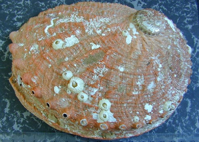
Database includes data on abalone size at maturity, collected from sites around Tasmania from 1988.
-

This resource is a map of Bottom Temperature and comes from from a simulation that uses the multi-model mean forcings from RCP8.5 projection to drive an ocean eddy-resolving model (OFAM3). Insights for Warming and Acidification Increased frequency and duration of marine heatwaves increase the likelihood of more frequent and severe coral bleaching events. Tasman Sea approaches a permanent marine heatwave state by GWL3. Great Barrier Reef and Ningaloo Reef will experience annual conditions for extreme bleaching by GWL3. Acidity at GWL3: Southern Ocean surface waters south of 60S will drop below an annual mean aragonite saturation state of 1. Values above 1.0 are required to produce calcareous shells or skeletons optimally. Values below 1 are considered corrosive, and skeletons and shells may be subject to dissolution. The ocean environment will become more stressful for marine organisms and ecosystems. The references for the simulations are: Feng, M., Zhang, X., Oke, P., Monselesan, D., Chamberlain, M. A., Matear, R. J., & Schiller, A. (2016). Invigorating ocean boundary current systems around Australia during 19792014: As simulated in a near-global eddy-resolving ocean model. Journal Of Geophysical Research-Oceans. Hayashida, H., Matear, R. J., & Strutton, P. G. (2020). Background nutrient concentration determines phytoplankton bloom response to marine heatwaves. Global Change Biology, 26(9), 48004811. https://doi.org/10.1111/gcb.15255 Hayashida, H., Matear, R. J., Strutton, P. G., & Zhang, X. (2020). Insights into projected changes in marine heatwaves from a high-resolution ocean circulation model. Nature Communications, 11(1), 19. https://doi.org/10.1038/s41467-020-18241-x Matear, R. J., Chamberlain, M. A., Sun, C., & Feng, M. (2015). Climate change projection for the western tropical Pacific Ocean using a high-resolution ocean model: Implications for tuna fisheries. Deep Sea Research Part II: Topical Studies in Oceanography, 113(0), 2246. Matear, R. J., Chamberlain, M. A., Sun, C., & Feng, M. (2013). Climate change projection of the Tasman Sea from an Eddy-resolving Ocean Model. Journal Of Geophysical Research-Oceans, 118(6), 29612976. Zhang, X., Oke, P. R., Feng, M., Chamberlain, M. A., Church, J. A., Monselesan, D., et al. (2016). A near-global eddy-resolving OGCM for climate studies. Geoscientific Model Development Discussions. Diagnostics The key ocean diagnostics are displayed according to Global Warming Levels (GWLs) using the 20 year period that define a given GWL. The key ocean diagnostics are: 1. Sea Surface Temperature monthly climatology 2. Surface Aragonite Saturation State monthly climatology 3. Surface pH monthly climatology 4. Intensity of Marine Heat Wave 5. Duration of Marine Heat Wave 6. NPP monthly climatology (N mol/m^2/s) 7. Degree Heating Weeks (average of the annual maximum value dhw_amax, maximum (dhw_max) and minimum (dhw_max) annual value over GWL period 8. Bottom Temperature 9. Full ocean depth temperature (note simulation used restoring to T and S below 2000m)10. Magnitude of Bottom Stress (bmf) 10. Bottom aragonite saturation state Data/confidence Confidence: high confidence in the direction of change, medium confidence in the magnitude of change and low confidence in the ecological consequence of the changes. (consistent with IPCC AR6) Limitation: ocean simulations that are not well suited for representing the high-resolution dynamics and features of the Australian coastal areas. https://github.com/AusClimateService/hazard_ocean/blob/main/README.md
-
These data were collected on the RV L'Astrolabe (platform code: FHZI) from 04/11/2008 to 11/11/2008 on a trip from Dumont D'Urville to Hobart. Maximum photochemical efficiency of photosystem II (PSII), also called maximum quantum yield of PSII (Fv/Fm), has become one of the most widely utilized fluorescence parameters in phytoplankton research. It represents the potential photochemical efficiency, which is the probability that the light energy captured by the photosynthetic apparatus is being utilized as photochemistry. Fv/Fm has been shown to have an instant response to variations in physical and chemical properties and is interpreted as a diagnostic of the overall health or competence of phytoplankton. Together with the absorption cross section area of PSII and chlorophyll concentration, it can be used to measure primary production (Cheah et al. 2011, Deep Sea Research). Seawater from 3 m depth was supplied continuously from the ship’s clean seawater line. FRR fluorescence yields were measured continuously at 1 minute intervals in dark-adapted state (! 15 minutes dark-adaptation) using a flash sequence consisting of a series of 100 subsaturation flashlets (1.1 μs flash duration and 2.8 μs interflash period) and a series of 20 relaxation flashlets (1.1 μs flash duration and 51.6 μs interflash period).
-

This record provides an overview of the NESP Marine and Coastal Hub Emerging Priorities project "National assessment of harmful algal bloom preparedness and future needs". No data outputs are planned for this project. -------------------- The 2025 South Australian harmful algal bloom (HAB) highlighted major gaps in Australia’s preparedness for large-scale marine HAB events, including limitations in surveillance capability, forecasting systems, coordination arrangements and long-term response planning. While HABs are not new to Australia, the scale, duration and ecological impacts of the South Australian event demonstrated the need for a broader national assessment of HAB science capability and policy readiness. This project will review Australia’s current capability for HAB surveillance, forecasting, response and management across environmental and seafood-safety domains. It will examine existing monitoring systems, research capability, early-warning approaches, coordination arrangements and operational policy settings across Commonwealth, state and territory jurisdictions. The review will consider lessons from the South Australian bloom alongside national and international approaches to HAB preparedness and management, including monitoring technologies, forecasting systems and risk mitigation strategies. It will also consider relevant recommendations from the Australian Senate inquiry into the South Australian algal bloom and broader national policy frameworks, including the draft Sustainable Ocean Plan. Project outputs will include an assessment of current national HAB capability, identification of critical knowledge and operational gaps, and recommendations for improving HAB preparedness, surveillance, forecasting, coordination and response capacity in Australia. Outputs • Final technical report [written]
-
Redmap is a primarily a website that invites the community to spot, log and map marine species that are uncommon in their region, or along particular parts of their coast. The information collected is mapped and displayed on the site, demonstrating, in time, how species distributions may be changing. Sightings are divided into two categories – those with a photo that can be ‘verified’ by a marine biologist, and sightings without photos that we call community sightings (anecdotal). All the information collected, with and without photos, is mapped and will be used in the following years to map out a ‘story’ of changes occurring in our marine environment. The main data collected includes the species sighted (normally selected from a list comprising preselected species of interest), the location, date/time and activity being undertaken. Other optional information gathered include biological data such as sex, size and weight and environmental data such as water depth and temperature and habitat. This record is associated with live data (and will subsequently change over time) and spatial elements have reduced accuracy. It is also subject to a three year embargo (ie. does not contain data less than three years old). If you wish to discuss obtaining a citable, static dataset, that is current and/or contains accurate spatial elements, please see Point of Contact.
-
'Weather@home ANZ' is a global citizen science distributed computing project being run as part of the Oxford-based 'weather@home' project, which is part of 'climateprediction.net'. In this experiment, a detailed limited area (regional) climate model is embedded within the less detailed 'driving' global model. This higher-resolution regional model is able to tell us in unprecedented detail about potential changes to patterns of weather as climate changes. In the initial 'weather@home' experiment launched in 2010, the project team released this regional modelling capability for three regions: Europe, Southern Africa and the Western USA. This capability has been extended to other regions around the world and the first such new region to be developed was the Australasian region encompassing Australia, New Zealand and surrounding areas, which was launched to the public in 2014. This particular part of the project - 'weatherathome ANZ' - has received support from the University of Oxford (U.K.), the U.K. Met. Office, the Universities of Melbourne and Tasmania (Australia), the Tasmanian Partnership for Advanced Computing and the New Zealand National Institute for Water and Atmospheric Research (NIWA). 'weather@home' has also been supported by Microsoft Research.
-

Metric: Impact score of fishery activity on species composition as determined by gear specificity. Measures how selectively fishing gear targets intended species versus unintentionally catching other species. This indicator helps assess the fishery’s influence on the balance and diversity of marine life.
-
The impacts of a small, free-field, surface explosion from a ship scuttling, on two crustacean species was examined. The southern rock lobster (Jasus edwardsii) and the spotted shore crab (Paragrapsus gaimardii) were used to compare the effects on crustaceans in a controlled experiment on animals distributed up to 500 m from the blasts. Methods for assessing damage included; mortality, behavioural experiments, and physiological assessments.
-
Data were collected from 28 artificial reefs varying in size and supporting different densities of transplanted kelp (Ecklonia radiata). We used rope fibre habitats (RFHs) attached to the benthos of the reefs and destructive sampling of understory algae to collect data on epifaunal invertebrates that naturally colonised the reefs (e.g. secondary productivity, species richness, Shannon diversity). The goal of the research was to understand how kelp structure influences the biodiversity and secondary productivity of epifauna.