 IMAS Metadata Catalogue
2025
Type of resources
Topics
Keywords
Contact for the resource
Provided by
Years
-

This record provides an overview of the NESP Marine and Coastal Hub project "Updating knowledge of Australian white sharks". For specific data outputs from this project, please see child records associated with this metadata. -------------------- The white shark is listed as Vulnerable and Migratory under Australia’s Environment Protection and Biodiversity Conservation (EPBC) Act 1999. Previous NESP-funded research provided updated estimates of breeding population size and trend, but uncertainty remained around juvenile nursery and pupping areas, movement patterns, and connectivity between eastern and south-western Australian populations. More recent evidence has also raised the possibility of a single Australian population. This project aimed to reduce uncertainty in the status, trends and population structure of white sharks in Australian waters, with a focus on identifying biologically important habitats and improving population assessment through expanded close-kin mark-recapture (CKMR) analyses. The project combined three major components: (1) pilot tagging studies of large adult females and juvenile sharks to improve understanding of movements, pupping areas and habitat use; (2) genetic analyses to assess stock structure and connectivity using samples collected across Australia, and where possible from South Africa and New Zealand; and (3) updated population assessment using expanded tissue sample collections and close-kin mark-recapture methods. Population estimates incorporated approximately 1,000 tissue samples from New South Wales together with additional samples from South Australia and Western Australia. Juvenile abundance information from the New South Wales shark management program was also integrated into the assessment framework. CKMR approaches used genetic identification of parent-offspring and half-sibling relationships to estimate adult abundance, survival and population trends. Project outputs included updated estimates of population size and trend, improved understanding of population connectivity and movement patterns, and refined information on potential nursery and critical habitat areas. These findings support white shark recovery planning, future monitoring design, and conservation assessment in Commonwealth and state waters. Outputs • New genetic samples and sequencing data for white sharks [dataset] • Tracking data from PAT tags [dataset] • Final technical report (including recommendations for systematic future research to assist in identifying additional critical habitat for the south-western white shark population) [written]
-
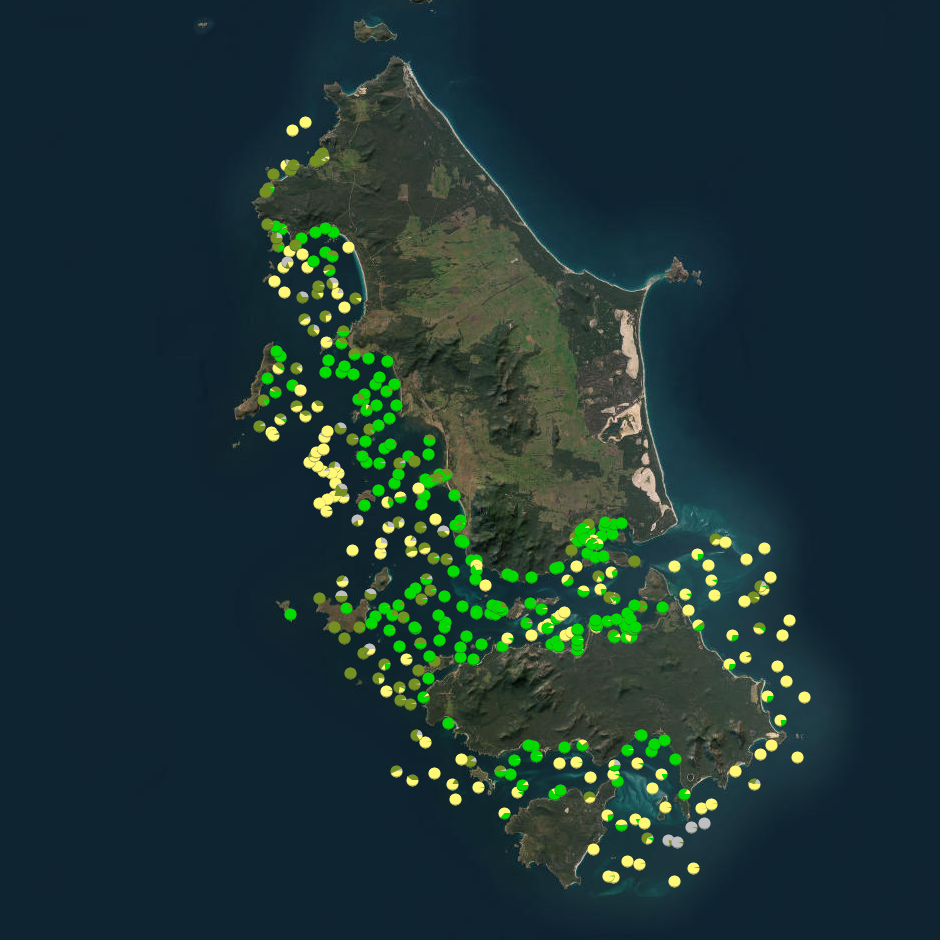
Seagrass beds are a dominant marine ecosystem of Tayaritja (the Furneaux Group of Islands) in the north-eastern waters off Tasmania. Historical coarse mapping has indicated extensive beds of Posidonia, Amphibolis, Heterozostera, and Zostera species, potentially comprising some of the largest and deepest seagrass extents found in temperate Australian waters. However, limited data on the distribution and ecological value of these seagrass habitats represents a significant knowledge gap in understanding Australia's wetland natural assets. This project mapped the extent, ecological composition, population structure, and blue carbon value of seagrass beds around Tayaritja. The study area focused on the coastal waters surrounding Flinders Island in the western Furneaux Group, with mapping extending from the high tide line to the depth limit of reliable optical detection (approximately 30 m), based on analysis of field data and satellite imagery capabilities in the region. The field validation component of this study involved deployment of benthic video platforms to capture imagery of seagrass beds and associated ecosystems. A field campaign deployed a Benthic Observation Survey System (BOSS) and unBaited Remote Underwater stereo-Video system (stereo-uBRUV) at approximately 400 locations to collect photoquadrats and validate remote sensing outputs. Imagery annotation was conducted in the SQUIDLE+ platform. The approach developed through this study contributed to the creation of the NESP Standard Operating Procedure (SOP) for Seagrass Mapping using Optical Remote Sensing (https://sustainabledevelopmentreform.github.io/nesp-sop-seagrass-mapping).. See the "Lineage" section of this record for full methodology of field collection techniques. See associated dataset https://doi.org/10.25959/e4s6-ge74 for habitat maps derived from field validation and remote sensing inputs.
-
The Black Rockcod (Epinephelus daemelii) is a large, slow-growing, long-lived reef fish that occurs in Australia along the coast of New South Wales, including at Lord Howe Island. Populations of black rockcod have been significantly reduced here due to overfishing, accidental hooking, and loss or degradation of estuarine and intertidal nursery habitats. As a result, the species is listed as ‘Vulnerable’ under both the Commonwealth Environmental Protection and Biodiversity Conservation Act 1999 and the NSW Fisheries Management Act 1994. Despite having been protected from fishing in NSW since 1983, black rockcod are still taken illegally, or caught incidentally and released, which can lead to mortality post-release from embolism. Its protection status results from concerns of population declines across its range. The NSW Government has identified long-term population monitoring as a a high priority for the species’ recovery plan. Broadscale surveys of black rockcod were first conducted using the diver Underwater Visual Census (UVC) technique in 2009-11 when 83 sites were sampled from Port Stephens to Cook Island in far northern NSW, including the waters of Lord Howe Island. This NESP Marine and Coastal Hub project 3.14 funded the repeat of these broadscale surveys in 2023, with 8 additional sites (91 total) sampled using the same technique. For each black rockcod sighting, the length of the fish was visually estimated by divers, and also filmed using a diver stereo camera system where possible to obtain an exact length measurement. Other attributes recorded included the habitat the fish was found in, if the sighting was cryptic (i.e. hidden or camouflaged), and the depth of the sighting. Based on the broadscale survey sites in 2009-11, a subset of 19 key Black rockcod survey sites along mainland NSW were established These comprised of two sites in the Cape Byron Marine Park (CBMP), five sites in the Solitary Islands Marine Park (SIMP) two sites at SW Rocks (Fish Rock), and ten sites within the Port Stephens-Great Lakes Marine Park (PSGLMP). An additional 18 key sites were established at Lord Howe Island (LHIMP) and surveyed in 2011, 2019, 2023 & 2024. These surveys involved an identical methodology to the broadscale surveys, but without the use of stereo cameras as diver estimates of fish size were shown to be reasonably similar. This NESP MaC Hub project 3.14 provided funding for the resurveying of the 37 total key sites (where weather permitted) in both 2023 and 2024. The data provided by this record includes: (1) all black rockcod sightings and measurements for broadscale sites (2023) and key sites (2023 & 2024); (2) a comparison of the counts of black rockcod recorded at broadscale sites in 2009-11 (n=83) and again in 2023 (n=91); and (3) a comparison of the count of black rockcod recorded at key monitoring sites in northern NSW (n=19) and Lord Howe Island (n=18) across monitoring years 2009-2024.
-
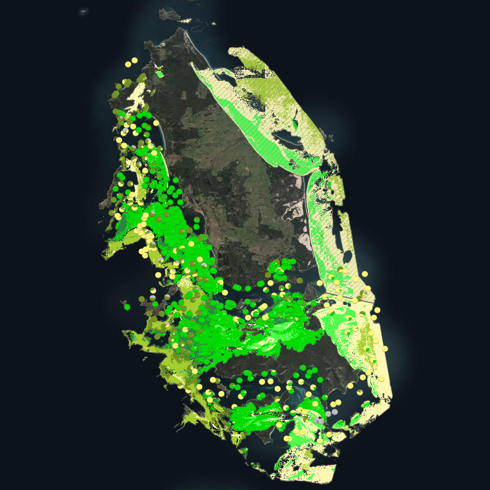
Seagrass beds are a dominant marine ecosystem of Tayaritja (the Furneaux Group of Islands) in the north-eastern waters off Tasmania. Historical coarse mapping has indicated extensive beds of Posidonia, Amphibolis, Heterozostera, and Zostera species, potentially comprising some of the largest and deepest seagrass extents found in temperate Australian waters. However, limited data on the distribution and ecological value of these seagrass habitats represents a significant knowledge gap in understanding Australia's wetland natural assets. This project mapped the extent, ecological composition, population structure, and blue carbon value of seagrass beds around Tayaritja, in partnership with the Tasmanian Aboriginal Centre. The study area focused on the coastal waters surrounding Flinders Island in the western Furneaux Group, with mapping extending from the high tide line to the depth limit of reliable optical detection (approximately 30 m), based on analysis of field data and satellite imagery capabilities in the region. This record specifically describes the benthic mapping component of the study. See https://doi.org/10.25959/WRXK-KV06 for imagery annotation data from the field validation campaigns. A combination of close-range remote sensing methods was used to map the extent and ecological values of seagrass beds. The approach developed through this study contributed to the creation of the NESP Standard Operating Procedure (SOP) for Seagrass Mapping using Optical Remote Sensing (https://sustainabledevelopmentreform.github.io/nesp-sop-seagrass-mapping).. High-resolution satellite imagery from Sentinel-2 (10 m) sensors, combined with bathymetric LiDAR data and oceanographic variables, was used to map baseline seagrass extent and composition. A field campaign deployed a Benthic Observation Survey System (BOSS) and unBaited Remote Underwater stereo-Video system (stereo-uBRUV) at approximately 400 locations to validate remote sensing outputs. From these data, maps were produced showing the extent and coverage of seagrass, sand, and macroalgae, and where possible, seagrass species composition, subject to water depth and clarity constraints. See the "Lineage" section of this record for full methodology. Three key types of mapping products were developed: ---Occurrence probability maps--- Continuous probability surfaces (0-100%), modelled from presence/absence data, indicating the likelihood of habitat presence at each pixel for: • Seagrass (all morphologies; > 5% cover observed in underwater field imagery) • Macroalgae species/assemblages • Sand ---Habitat percentage cover maps--- Quantitative estimates of percent cover for each habitat category: • Seagrass (all morphologies) • Macroalgae species/assemblages • Sand ---Derived products--- • Baseline binary presence/extent maps derived from optimised probability thresholds: ○ Seagrass: sgprob > 0.5 & sgprob > macroprob & sandcover < 0.9 ○ Macroalgae: macroprob > 0.5 & macroprob > sgprob & sandcover < 0.9 ○ Sand: sandprob > 0.5 & sandcover < 0.2 • Predicted seagrass species composition of binary extent map. • Fractional cover visualisation: combining cover percentages of multiple habitats into a single composite product • Composite habitat maps: combining binary habitat extents and delineating mixed habitat classes These complementary products serve different purposes: probability maps provide confidence measures, extent maps delineate habitat boundaries, percent cover maps support quantitative analysis of habitat density patterns, and composite habitat maps represent the diversity of mixed habitat classes. Together, they provide a comprehensive understanding of seagrass and associated habitat distribution across the study area.
-

This record provides an overview of the NESP Marine and Coastal Hub Research Plan 2024 Emerging Priorities project "Modelling adult abundance and habitat distribution of Maugean skate". For specific data outputs from this project, please see child records associated with this metadata. -------------------- The Maugean skate (Zearaja maugeana) is listed as Endangered under Tasmania’s Threatened Species Protection Act 1995 and the Commonwealth Environment Protection and Biodiversity Conservation Act 1999. The species has one of the most restricted distributions of any extant elasmobranch, having only been recorded in Macquarie Harbour and Bathurst Harbour in western Tasmania. The Macquarie Harbour population is small (~3,000 individuals) and exposed to ongoing environmental pressures, making robust population assessment and habitat monitoring a high conservation priority. This project investigated Close Kin Mark Recapture (CKMR) as a priority method for estimating historical abundance and supporting long-term monitoring of Maugean skate in Macquarie Harbour, as identified in the species’ Roadmap of Agreed Actions and 2023 Conservation Advice. CKMR uses next-generation sequencing to identify close relatives among sampled individuals and model breeding population size, adult survival and population trends. A second project component modelled the distribution of critical Maugean skate habitat in relation to dissolved oxygen, temperature and depth. Telemetry data from tagged skates were combined with biophysical harbour models and habitat selection modelling to generate potential habitat maps for a 2017-18 hindcast period and forecast scenarios based on recent and evolving water-quality conditions. These maps were assessed against existing knowledge of skate habitat to identify critical areas within Macquarie Harbour and inform future spatial and temporal sampling strategies. Project outputs include independent population-assessment methods and hindcast/forecast habitat suitability maps for Macquarie Harbour. These outputs support conservation decision-making, evaluation of remediation scenarios, identification of critical habitat areas, and future monitoring and sampling design. Outputs • High-quality DNA sequences of Maugean skate [sequencing data] • Hindcast maps (2017-18) of potential Maugean skate occupation [spatial data] • Recent and forecast (evolving) maps of potential Maugean skate occupation under different management scenarios [spatial data] • Estimates of spawning stock abundance of the Maugean skate from CKMR analysis [data contained in written report] • Final project report [written]
-
This record provides an overview of the NESP Marine and Coastal Hub project "Synthesis of environmental values to support the review of Australian Marine Park management plans". For specific data outputs from this project, please see child records associated with this metadata. -------------------- Parks Australia (Australian Government) manage 60 Australian Marine Parks (AMPs) around the country, covering an area of 3.8 million square kilometres, or 43% of all Australian waters. The approach to managing AMPs is set out in eight Management Plans, one for each of the five marine park networks (North, North-west, South-west, South-east and Temperate East) and one each for the Coral Sea Marine Park, Christmas Island Marine Park and Cocos (Keeling) Islands Marine Park. A statutory review of Management Plans for the North, North-west, South-west, Temperate-East networks and the Coral Sea Marine Park is scheduled for 2028. This review requires accessible, synthesised evidence on science outputs, natural values, socio-economic values and pressures across parks and networks. This project supports the 2028 statutory review by synthesising relevant NESP Marine Biodiversity Hub, NESP Marine and Coastal Hub, and Parks Australia-contracted work from 2017 onwards. These reports bring together science outputs, natural values, pressures and socio-economic information from 2017 onwards, aggregated where possible to Park and Network scales. The project reviewed the data summaries, workflows and reporting tools used to prepare the synthesis reports, and identified opportunities to better integrate this infrastructure. These recommendations support future AMP management effectiveness reporting, statutory review processes, and national environmental assessment and impact reporting. Outputs • Catalogue of available data for each reviewed Network (North, North-west, South-west, Temperate East) and the Coral Sea AMP [data inventory] • Synthesis report [written] for each region that will include: - a summary of science activity and outputs since 2017 - summaries of the state and trend of Natural Values and Pressures since 2017, aggregated by Ecosystem Component, Ecosystem Depth Zone, AMP, and AMP Zone type (where possible) • Final technical report (including recommendations to support AMP management and reporting) [written]
-

This record provides an overview of the NESP Marine and Coastal Hub project "Improving socio-ecological understanding of natural values in Australian Marine Parks". No public data outputs will be generated by this project. -------------------- Parks Australia (Australian Government) manage 60 Australian Marine Parks (AMPs) around the country, covering an area of 3.8 million square kilometres, or 43% of all Australian waters. The approach to managing AMPs is set out in eight Management Plans: one for each of the five marine park networks (North, North-west, South-west, South-east and Temperate East) and one each for the Coral Sea Marine Park, Christmas Island Marine Park and Cocos (Keeling) Islands Marine Park. A statutory review of Management Plans for the North, North-west, South-west, Temperate-East networks and the Coral Sea Marine Park is scheduled for 2028. Socio-economic information is needed alongside natural values data to assess management effectiveness and understand how Australians use, value and perceive the marine park system. This project progressed the use of socio-economic information to support Australian Marine Park management and the 2028 management plan review. It builds on previous NESP research by redeveloping socio-economic benchmarks aligned with Parks Australia’s sentinel park approach and network-scale reporting, and complements NESP-led data synthesis projects (SS2, D7, 1.3, 4.20 and 4.21). The project redesigned two repeatable national surveys: a knowledge, attitudes and practice boat ramp survey targeting recreational fishers and non-fishers who use Australian Marine Parks, and a general public survey exploring broader community awareness, attitudes and views on management zones. Nine boat-ramp survey locations were selected with Parks Australia to support park- and network-scale estimates of recreational use covering the Coral Sea, and North, North-west, South-west, South-east and Temperate East networks. The survey design and sampling regime provide a basis for assessing changes in awareness, attitudes and use patterns since the 2019/20 benchmark. Combined with natural values data, these outputs strengthen the Management Effectiveness system and support more integrated reporting on the social, economic and ecological values of Australian Marine Parks. Outputs • Responses from recreational user surveys [dataset]. In accordance with National Statement on Ethical Conduct in Human Research, only aggregated outputs will be made publicly available. • Final technical report [written]
-

The Blue Economy CRC Futures of Seafood project is an initiative that maps, models and describes the spatial, economic and social impacts of the full suite of government policies and targets that impact ocean access on the seafood industry. This resource acts as a 'parent' record to collate IMAS-hosted data records relevant to the Futures of Seafood project delivered by CSIRO , in collaboration with NESP Marine and Coastal Hub Project 4.20.
-
The SeaMap Tasmania project undertook mapping of seafloor habitats across the nearshore Tasmanian coastline (0-40 m) - the first state to compile a statewide asssimilated benthic habitat dataset. This initiative comprised of collating aerial photography (from archives), acoustic mapping, and conducting underwater video surveys and field-based visual observations. From this, 1:25,0000 scale habitat maps were created for shallow coastal water to within 1.5 km of the coastline (or 40 m depth, which ever was arrived at first). This record provided access to the raw video and associated annotations from video transects, which were subsequently used as validation (ground-truthing) for habitat mapping. A submersible digital video camera was deployed at selected locations around the Tasmanian coastline. These samples were used to verify the aerial photography and echo sounder substrate classification and obtain more detailed information on biological assemblages. Transects were undertaken from the LWM (Low water mark) to 80 metres in depth or 1.5 kms from shore. Positional information was recorded for each video drop as a series of DGPS coordinates and also as a direct overlay of the DGPS output (position, date and time) onto the video.
-

Climate change and population growth are accelerating the need for diverse solutions to coastal protection. Traditionally, shorelines are armoured with conventional "hard" or "grey" engineering structures such as seawalls which are non-adaptive and come with significant economic, environmental and social costs. While hard structures have a place in coastal protection, alternative 'living shorelines' methods harness natural ecosystems to reduce coastal erosion and flooding and provide co-benefits such as carbon sequestration. They may consist of dunes, wetlands and biogenic reefs: either alone (‘soft approach’) or in combination with hard structures (‘hybrid approach’). The Living Shorelines Australia project (https://livingshorelines.com.au) compiled a database of nature-based ("soft" or "hybrid") coastal protection projects from across Australia. This database acts as a tool to help coastal managers make informed decisions by providing as many examples as possible of where these solutions have been used, how they were used, and how effective they are in different contexts. The information in this database was collected through direct engagement with coastal managers and stakeholders, a literature search, and informal internet searching. Under the NESP Marine and Coastal Hub Project 1.10, this database was established and populated with 138 projects identified through the process described above. Since then (2022), the database has continued to be updated by The University of Melbourne and now contains 200 nature-based coastal protection projects.