 IMAS Metadata Catalogue
Mapping of temperate subtidal seagrass beds in Tayaritja Sea Country (Furneaux Group of Islands), Lutruwita (Tasmania) (NESP MaC 3.6)
Seagrass beds are a dominant marine ecosystem of Tayaritja (the Furneaux Group of Islands) in the north-eastern waters off Tasmania. Historical coarse mapping has indicated extensive beds of Posidonia, Amphibolis, Heterozostera, and Zostera species, potentially comprising some of the largest and deepest seagrass extents found in temperate Australian waters. However, limited data on the distribution and ecological value of these seagrass habitats represents a significant knowledge gap in understanding Australia's wetland natural assets.
This project mapped the extent, ecological composition, population structure, and blue carbon value of seagrass beds around Tayaritja, in partnership with the Tasmanian Aboriginal Centre. The study area focused on the coastal waters surrounding Flinders Island in the western Furneaux Group, with mapping extending from the high tide line to the depth limit of reliable optical detection (approximately 30 m), based on analysis of field data and satellite imagery capabilities in the region.
This record specifically describes the benthic mapping component of the study. See https://doi.org/10.25959/WRXK-KV06 for imagery annotation data from the field validation campaigns.
A combination of close-range remote sensing methods was used to map the extent and ecological values of seagrass beds. The approach developed through this study contributed to the creation of the NESP Standard Operating Procedure (SOP) for Seagrass Mapping using Optical Remote Sensing ( https://sustainabledevelopmentreform.github.io/nesp-sop-seagrass-mapping)..
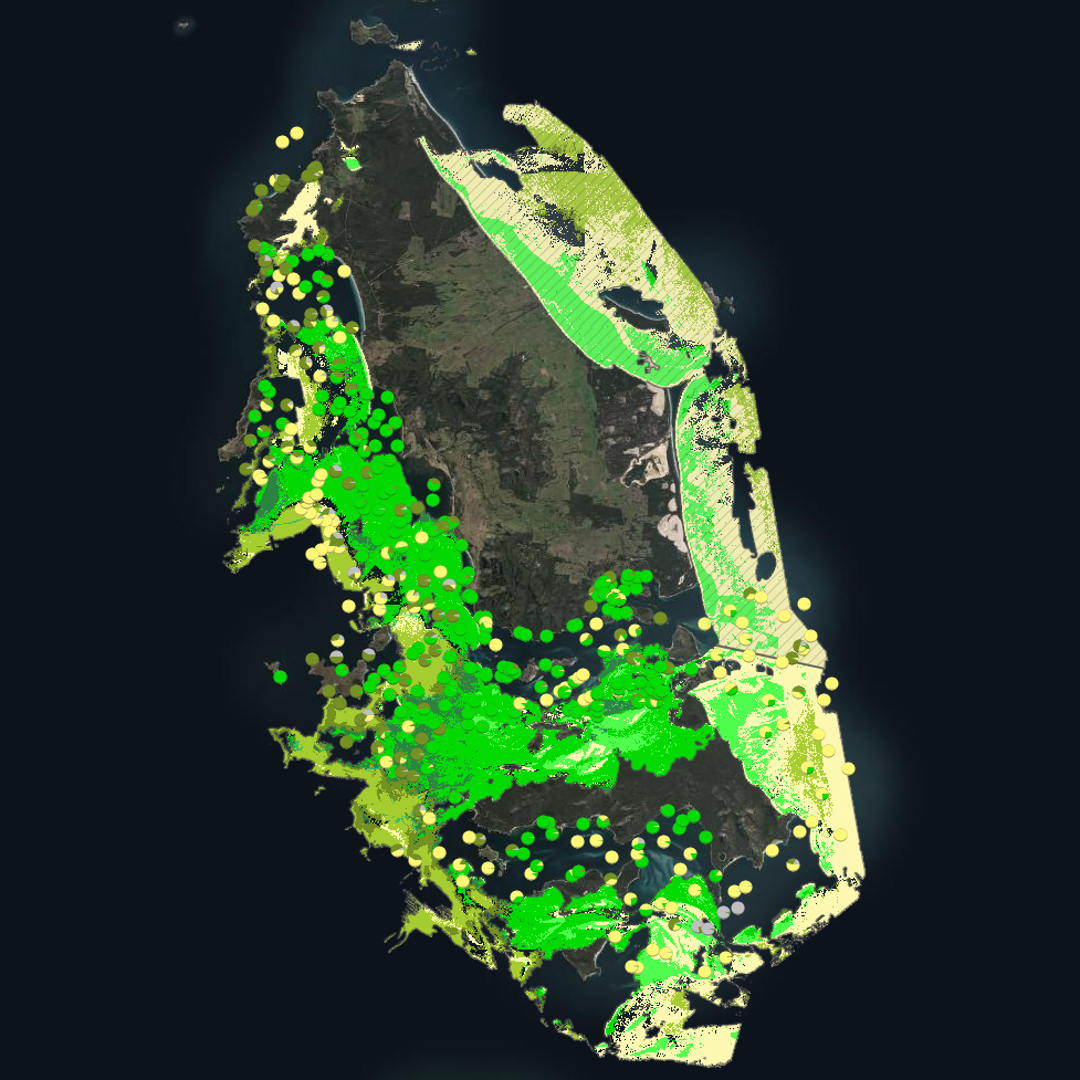
High-resolution satellite imagery from Sentinel-2 (10 m) sensors, combined with bathymetric LiDAR data and oceanographic variables, was used to map baseline seagrass extent and composition. A field campaign deployed a Benthic Observation Survey System (BOSS) and unBaited Remote Underwater stereo-Video system (stereo-uBRUV) at approximately 400 locations to validate remote sensing outputs. From these data, maps were produced showing the extent and coverage of seagrass, sand, and macroalgae, and where possible, seagrass species composition, subject to water depth and clarity constraints.
See the "Lineage" section of this record for full methodology.
Three key types of mapping products were developed:
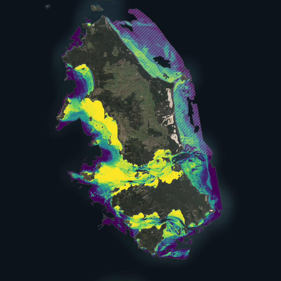
---Occurrence probability maps---
Continuous probability surfaces (0-100%), modelled from presence/absence data, indicating the likelihood of habitat presence at each pixel for:
• Seagrass (all morphologies; > 5% cover observed in underwater field imagery)
• Macroalgae species/assemblages
• Sand
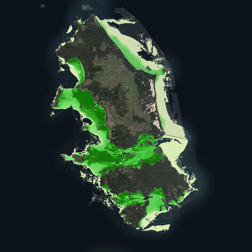
---Habitat percentage cover maps---
Quantitative estimates of percent cover for each habitat category:
• Seagrass (all morphologies)
• Macroalgae species/assemblages
• Sand
---Derived products---
• Baseline binary presence/extent maps derived from optimised probability thresholds:
○ Seagrass: sgprob > 0.5 & sgprob > macroprob & sandcover < 0.9
○ Macroalgae: macroprob > 0.5 & macroprob > sgprob & sandcover < 0.9
○ Sand: sandprob > 0.5 & sandcover < 0.2
• Predicted seagrass species composition of binary extent map.
• Fractional cover visualisation: combining cover percentages of multiple habitats into a single composite product
• Composite habitat maps: combining binary habitat extents and delineating mixed habitat classes
These complementary products serve different purposes: probability maps provide confidence measures, extent maps delineate habitat boundaries, percent cover maps support quantitative analysis of habitat density patterns, and composite habitat maps represent the diversity of mixed habitat classes. Together, they provide a comprehensive understanding of seagrass and associated habitat distribution across the study area.
Simple
Identification info
- Date (Creation)
- 2025-04-26
Identifier
- Title
- Information and documentation - Digital object identifier system
- Citation identifier
- ISO 26324:2012
- Code
- 10.25959/e4s6-ge74
- Codespace
- doi.org
- Description
- Digital Object Identifier (DOI)
Principal investigator
Collaborator
Collaborator
Collaborator
Collaborator
Collaborator
Collaborator
Collaborator
Collaborator
- Credit
- The data collections described in this record are funded by the Australian Government Department of Climate Change, Energy, the Environment and Water (DCCEEW) through the NESP Marine and Coastal Hub. In addition to NESP (DCCEEW) funding, this project is matched by an equivalent amount of in-kind support and co-investment from project partners and collaborators.
- Status
- Completed
Point of contact
Point of contact
- Topic category
-
- Biota
Extent

Temporal extent
- Time period
- 2020-01-01 2023-12-31
Vertical element
- Minimum value
- 0
- Maximum value
- 30
- Identifier
- EPSG::5715
- Name
- MSL depth
- Maintenance and update frequency
- Not planned
Resource format
- Date
- Keywords (Project)
-
- National Environmental Science Program (NESP) Marine and Coastal Hub
- GCMD Earth science Keywords
Resource constraints
- Classification
- Unclassified
Resource constraints
- Other constraints
- This dataset is hosted by the Institute for Marine and Antarctic Studies (IMAS), University of Tasmania, on behalf of NESP Marine and Coastal Hub Project 3.6.
Resource constraints
- Linkage
-
http://i.creativecommons.org/l/by/4.0/88x31.png
License Graphic
- Title
- Creative Commons Attribution 4.0 International License
- Website
-
http://creativecommons.org/licenses/by/4.0/
License Text
- Other constraints
- Cite data as: Lucieer, V., Ierodiaconou, D., Lyons, M., Monk, J., Strain, E., Flukes, E., Hulls, J., Carnell, P., Dalby, O., Ellis, M. R., Sherman, C., Fractal, K., Yusuf, A., Trevathan-Tackett, S., Wise, A., Maher, F., & Cozens, Z. (2025). Mapping of temperate subtidal seagrass beds in Tayaritja Sea Country (Furneaux Group of Islands), Lutruwita (Tasmania) [Data set]. Institute for Marine and Antarctic Studies. https://doi.org/10.25959/E4S6-GE74
Associated resource
- Title
- Related dataset: Imagery from BOSS and uBRUVs deployed for mapping temperate subtidal seagrass of Tayaritja Sea Country (Furneaux Group of Islands), Lutruwita (Tasmania)
Identifier
- Code
- 10.25959/wrxk-kv06
- Codespace
- doi.org
- Association Type
- Cross reference
Associated resource
- Title
- NESP MaC Project 3.6 - Exploring the distribution and ecological value of seagrass at the Furneaux Islands, Tasmania, 2023-2025 (IMAS, Deakin Uni)
Identifier
- Association Type
- Dependency
- Initiative Type
- Project
- Language
- English
- Character encoding
- UTF8
Distribution Information
- Distribution format
-
- Geotiff
- OnLine resource
- DATA ACCESS - derived products (binary habitat extents, seagrass species composition, composite habitat map)
- OnLine resource
- DATA ACCESS - probability of occurrence for each habitat class
- OnLine resource
- DATA ACCESS - percent cover for each habitat class
- OnLine resource
- DATA ACCESS - fractional cover detection products (multiband probability and % cover for all habitat classes)
- OnLine resource
-
MaC_3_6_Furneaux_fractionalcover
MAP - Fractional cover of all habitats
- OnLine resource
-
MaC_3_6_Furneaux_seagrass_extent_mask
MAP - Seagrass baseline extent (binary)
- OnLine resource
-
MaC_3_6_Furneaux_proboccurrence_seagrass_mask
MAP - seagrass probability of occurrence
- OnLine resource
-
MaC_3_6_Furneaux_perccover_seagrass_mask
MAP - seagrass percent cover
- OnLine resource
-
MaC_3_6_Furneaux_domspecies_seagrass
MAP - dominant seagrass species
- OnLine resource
-
MaC_3_6_Furneaux_habitat_combined_mask
MAP - combined benthic habitat map
- OnLine resource
- View & explore mapping products in Seamap Australia
- OnLine resource
- View underwater imagery (BOSS, uBRUV) on Squidle+
Resource lineage
- Statement
- ----Field Data Collection---- Field data collection followed the protocols outlined in Section 5 of the Seagrass Mapping SOP (https://sustainabledevelopmentreform.github.io/nesp-sop-seagrass-mapping/#5-training-data-collection-and-curation). Two stereo-video platforms were deployed using a statistically balanced sampling approach. See https://doi.org/10.25959/WRXK-KV06 for a full description and access to field validation data. ---Satellite Imagery--- Sentinel-2 multispectral imagery from 01-01-2020 to 31-12-2023 was used to create multi-temporal stacks. Clouds were masked using Google Cloud Score Plus. Composite images were produced using percentile metrics (20th, 40th, 60th, 80th) ---Environmental Data Sources--- Several ancillary data sources were integrated to provide information on water depth (influences light availability) and improve classification accuracy: • High-resolution LiDAR bathymetry from surveys conducted for the Australian Hydrographic Office • Lower-resolution LiDAR and sonar bathymetry to fill gaps in the primary dataset • Derived products including slope and rugosity at multiple scales • Wavewatch III wave hindcast model (metrics included average wave power, maximum wave power, standard deviation) Data was then interpolated to create a uniform grid with appropriate spatial resolution for the study area. ---Classification Approach--- A Boosted Regression Tree machine learning algorithm was selected for its effectiveness with complex environmental data, with parameters optimised for this study. The classification approach consisted of three main steps: • Probabilistic Classification: Generation of a continuous probability (from classification trees) surface indicating the likelihood of seagrass (+ macroalgae/sand) presence at each pixel • Habitat percent cover regression: Generation of continuous percentage cover estimates (from regression trees) indicating cover of seagrass (+ macroalgae/sand) in each pixel • Threshold Selection and Extent Mapping: Determination of a probability threshold, combining with information from other modelled products and manual editing boundaries, to define a baseline seagrass extent See 3.6 Case Study SOP (https://sustainabledevelopmentreform.github.io/nesp-sop-seagrass-mapping/case_study_NESP3.6/NESP_3.6_case_study.html) for a full description of the modelling approach and associated code.
- Hierarchy level
- Dataset
Metadata
- Metadata identifier
- urn:uuid/08067a15-2615-4b3e-9b04-23f6a08abb75
- Language
- English
- Character encoding
- UTF8
Point of contact
Type of resource
- Resource scope
- Dataset
- Metadata linkage
-
https://metadata.imas.utas.edu.au/geonetwork/srv/eng/catalog.search#/metadata/08067a15-2615-4b3e-9b04-23f6a08abb75
Point of truth URL of this metadata record
- Date info (Creation)
- 2015-05-06T11:44:25
- Date info (Revision)
- 2026-06-27T10:46:18
Metadata standard
- Title
- ISO 19115-3:2018
Overviews
Spatial extent

Provided by
