 IMAS Metadata Catalogue
SEAGRASS
Type of resources
Topics
Keywords
Contact for the resource
Provided by
Years
-
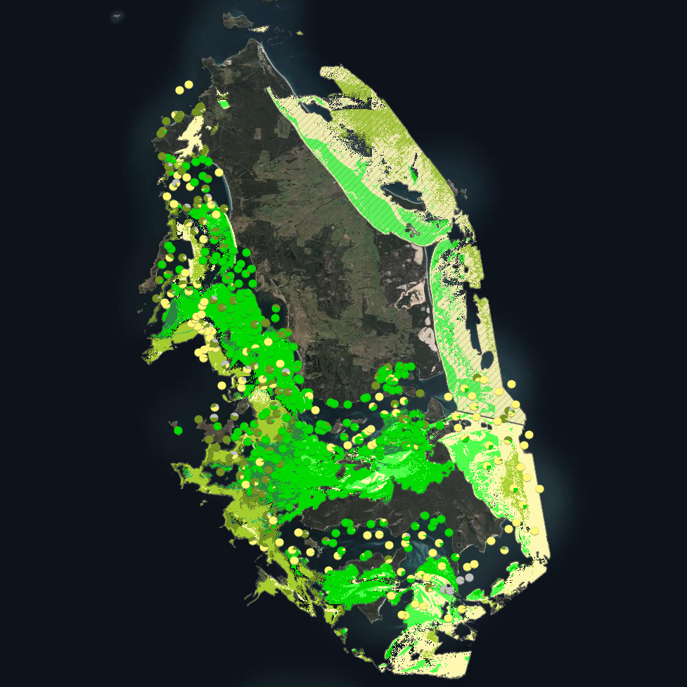
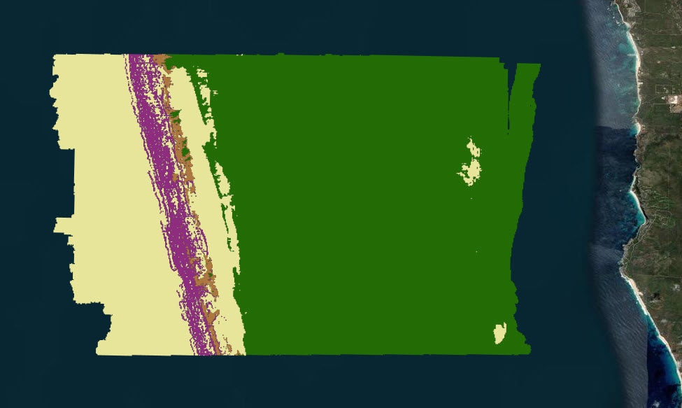
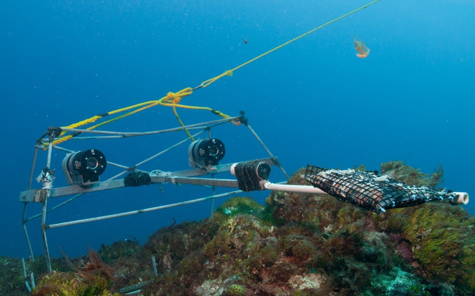
***This record contains a subset of benthic habitat data from https://doi.org/10.25959/E4S6-GE74 (NESP MaC Project 3.6) rehosted for the purposes of the Seamap Australia collaborative project.*** Seagrass beds are a dominant marine ecosystem of Tayaritja (the Furneaux Group of Islands) in the north-eastern waters off Tasmania. Historical coarse mapping has indicated extensive beds of Posidonia, Amphibolis, Heterozostera, and Zostera species, potentially comprising some of the largest and deepest seagrass extents found in temperate Australian waters. However, limited data on the distribution and ecological value of these seagrass habitats represents a significant knowledge gap in understanding Australia's wetland natural assets. This project mapped the extent, ecological composition, population structure, and blue carbon value of seagrass beds around Tayaritja, in partnership with the Tasmanian Aboriginal Centre, as part of NESP Marine and Coastal Hub Project 3.6. The study area focused on the coastal waters surrounding Flinders Island in the western Furneaux Group, with mapping extending from the high tide line to the depth limit of reliable optical detection (approximately 30 m), based on analysis of field data and satellite imagery capabilities in the region. This metadata record specifically describes the benthic mapping component of the study. A combination of close-range remote sensing methods was used to map the extent and ecological values of seagrass beds. High-resolution satellite imagery from Sentinel-2 (10 m) sensors, combined with bathymetric LiDAR data and oceanographic variables, was used to map baseline seagrass extent and composition. A field campaign deployed a Benthic Observation Survey System (BOSS) and unBaited Remote Underwater stereo-Video system (stereo-uBRUV) at approximately 400 locations to validate remote sensing outputs, collecting field photo quadrats and rhizome cores. From these data, maps were produced showing the extent and coverage of seagrass, sand, and macroalgae, and where possible, seagrass species composition, subject to water depth and clarity constraints. See the "Lineage" section of this record for full methodology.
-
The Australasian Coastal Restoration Network (ACRN) database collates information about coastal restoration projects in eight different ecosystems across Australia and New Zealand: shellfish, macroalgae, seagrass, mangrove, saltmarsh, coastal wetland and coral environments. This record represents a static snapshot of the database made in March 2020. The ACRN website (https://www.acrn.org.au) may contain more recent updates to the database.
-

Seagrass beds are a dominant marine ecosystem of Tayaritja (the Furneaux Group of Islands) in the north-eastern waters off Tasmania. Historical coarse mapping has indicated extensive beds of Posidonia, Amphibolis, Heterozostera, and Zostera species, potentially comprising some of the largest and deepest seagrass extents found in temperate Australian waters. However, limited data on the distribution and ecological value of these seagrass habitats represents a significant knowledge gap in understanding Australia's wetland natural assets. This project mapped the extent, ecological composition, population structure, and blue carbon value of seagrass beds around Tayaritja, in partnership with the Tasmanian Aboriginal Centre. The study area focused on the coastal waters surrounding Flinders Island in the western Furneaux Group, with mapping extending from the high tide line to the depth limit of reliable optical detection (approximately 30 m), based on analysis of field data and satellite imagery capabilities in the region. This record specifically describes the benthic mapping component of the study. See https://doi.org/10.25959/WRXK-KV06 for imagery annotation data from the field validation campaigns. A combination of close-range remote sensing methods was used to map the extent and ecological values of seagrass beds. The approach developed through this study contributed to the creation of the NESP Standard Operating Procedure (SOP) for Seagrass Mapping using Optical Remote Sensing (https://sustainabledevelopmentreform.github.io/nesp-sop-seagrass-mapping).. High-resolution satellite imagery from Sentinel-2 (10 m) sensors, combined with bathymetric LiDAR data and oceanographic variables, was used to map baseline seagrass extent and composition. A field campaign deployed a Benthic Observation Survey System (BOSS) and unBaited Remote Underwater stereo-Video system (stereo-uBRUV) at approximately 400 locations to validate remote sensing outputs. From these data, maps were produced showing the extent and coverage of seagrass, sand, and macroalgae, and where possible, seagrass species composition, subject to water depth and clarity constraints. See the "Lineage" section of this record for full methodology. Three key types of mapping products were developed: ---Occurrence probability maps--- Continuous probability surfaces (0-100%), modelled from presence/absence data, indicating the likelihood of habitat presence at each pixel for: • Seagrass (all morphologies; > 5% cover observed in underwater field imagery) • Macroalgae species/assemblages • Sand ---Habitat percentage cover maps--- Quantitative estimates of percent cover for each habitat category: • Seagrass (all morphologies) • Macroalgae species/assemblages • Sand ---Derived products--- • Baseline binary presence/extent maps derived from optimised probability thresholds: ○ Seagrass: sgprob > 0.5 & sgprob > macroprob & sandcover < 0.9 ○ Macroalgae: macroprob > 0.5 & macroprob > sgprob & sandcover < 0.9 ○ Sand: sandprob > 0.5 & sandcover < 0.2 • Predicted seagrass species composition of binary extent map. • Fractional cover visualisation: combining cover percentages of multiple habitats into a single composite product • Composite habitat maps: combining binary habitat extents and delineating mixed habitat classes These complementary products serve different purposes: probability maps provide confidence measures, extent maps delineate habitat boundaries, percent cover maps support quantitative analysis of habitat density patterns, and composite habitat maps represent the diversity of mixed habitat classes. Together, they provide a comprehensive understanding of seagrass and associated habitat distribution across the study area.
-
Predictions of dominant habitats were completed as part of a report funded by the NESP Marine & Coastal Hub. This report focussed on an IUCN II zone in the South-west Corner Marine Park off the 'Capes region' near Margaret River. This modelling contains data from stereo Baited Remote Underwater Video and panoramic drop camera, and was completed using the FSS-GAM package in R. Predictions are at two different scales and resolutions, one using the broad 250 metre resolution Geoscience Australia 2009 bathymetry grid (http://dx.doi.org/10.4225/25/53D99B6581B9A) and the other using a 5 metre resolution Geoscience Australia multibeam survey (https://dx.doi.org/10.26186/145281).
-
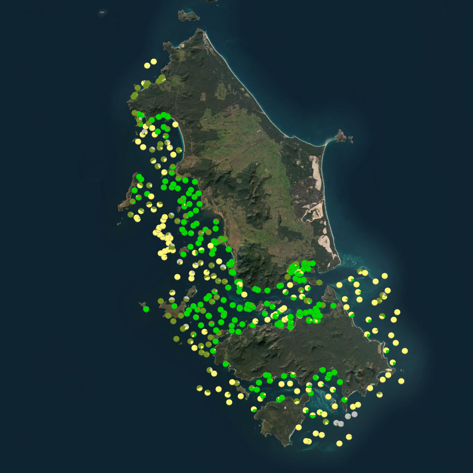
Seagrass beds are a dominant marine ecosystem of Tayaritja (the Furneaux Group of Islands) in the north-eastern waters off Tasmania. Historical coarse mapping has indicated extensive beds of Posidonia, Amphibolis, Heterozostera, and Zostera species, potentially comprising some of the largest and deepest seagrass extents found in temperate Australian waters. However, limited data on the distribution and ecological value of these seagrass habitats represents a significant knowledge gap in understanding Australia's wetland natural assets. This project mapped the extent, ecological composition, population structure, and blue carbon value of seagrass beds around Tayaritja. The study area focused on the coastal waters surrounding Flinders Island in the western Furneaux Group, with mapping extending from the high tide line to the depth limit of reliable optical detection (approximately 30 m), based on analysis of field data and satellite imagery capabilities in the region. The field validation component of this study involved deployment of benthic video platforms to capture imagery of seagrass beds and associated ecosystems. A field campaign deployed a Benthic Observation Survey System (BOSS) and unBaited Remote Underwater stereo-Video system (stereo-uBRUV) at approximately 400 locations to collect photoquadrats and validate remote sensing outputs. Imagery annotation was conducted in the SQUIDLE+ platform. The approach developed through this study contributed to the creation of the NESP Standard Operating Procedure (SOP) for Seagrass Mapping using Optical Remote Sensing (https://sustainabledevelopmentreform.github.io/nesp-sop-seagrass-mapping).. See the "Lineage" section of this record for full methodology of field collection techniques. See associated dataset https://doi.org/10.25959/e4s6-ge74 for habitat maps derived from field validation and remote sensing inputs.
-
This record provides an overview of the NESP Marine and Coastal Hub small-scale study - "A national framework for improving seagrass restoration". For specific data outputs from this project, please see child records associated with this metadata. -------------------- Seagrasses provide resources and ecosystem services critical to the health of coastal ecosystems and human populations. They increase water clarity, stabilise sediments and reduce coastal erosion, sequester carbon, and provide habitat and food to marine animals, including commercially important fish and invertebrates. Across Australia, the loss of >275,000 ha of seagrass meadows and associated ecosystem services—valued at AU$ 5.3 billion—has contributed to the long-term degradation of estuarine and coastal marine ecosystems. Restoration of seagrass is critical for improving the health and function of these ecosystems and sustaining coastal communities and industries that depend on them, yet restoration projects to date typically occur at small scales, driven by local priorities and with variable success. This project addressed this problem by bringing together scientists and key stakeholders to collate knowledge on seagrass ecology and restoration, and generated a framework to scaling-up restoration nationally. A national workshop with experts identified a shortlist of drivers key to restoration success, including sediment dynamics, microbial communities, hydrodynamics, and species interactions. It highlighted the importance of incorporating seagrass genetics and life histories into site and donor material selection to improve long-term resilience. New technologies such as eDNA, automation, and AI were also assessed for their potential to improve monitoring and reduce costs, while standardised methodologies and molecular tools were recommended to track microbial indicators and site suitability. A key insight from the workshop was the central role of sediment processes in feedback loops that determine seagrass health—providing a foundation for more effective, scalable restoration strategies. On-ground case studies were conducted in Western Australia and New South Wales to test the proposed restoration framework in collaboration with Indigenous and community partners: sediment quality assessment and manipulation (Gamay Rangers, UNSW); seed and seedling capture using sediment-filled hessian tubes (Malgana Rangers, UWA); and large-scale seed collection for seed-based restoration through the 'Seeds for Snapper' initiative (OzFish and UWA). These trials demonstrated the effectiveness of community-led restoration and reinforced the potential of seed-based methods for scaling up seagrass recovery. Outputs • Effect of sediment quality and manipulation on seagrass transplant success [field data] • Locations and health of beachcast fragments of Posidonia in Botany Bay [field data] • Effect of engineering hydrodynamics (by use of hessian socks) on seagrass transplant success [field data] • Final project report [written]
-
Fish annotations of stereo Baited Remote Underwater Video and panoramic drop camera imagery, were completed as part of a report funded by the NESP Marine & Coastal Hub. This report focussed on an IUCN II zone in the South-west Corner Marine Park off the 'Capes region' near Margaret River. These data were analysed in EventMeasure using standard operating procedures for the annotation of remote stereo imagery.
-
This data is from the 2021 'Seeds for Snapper' season which is a community volunteer seed based seagrass restoration program located in Perth, Western Australia. It details the effort that went into the collection of Posidonia australis seagrass fruit including number of divers, number of shore support personnel, volunteered hours, and fruit collection metrics (volume, estimated number).
-
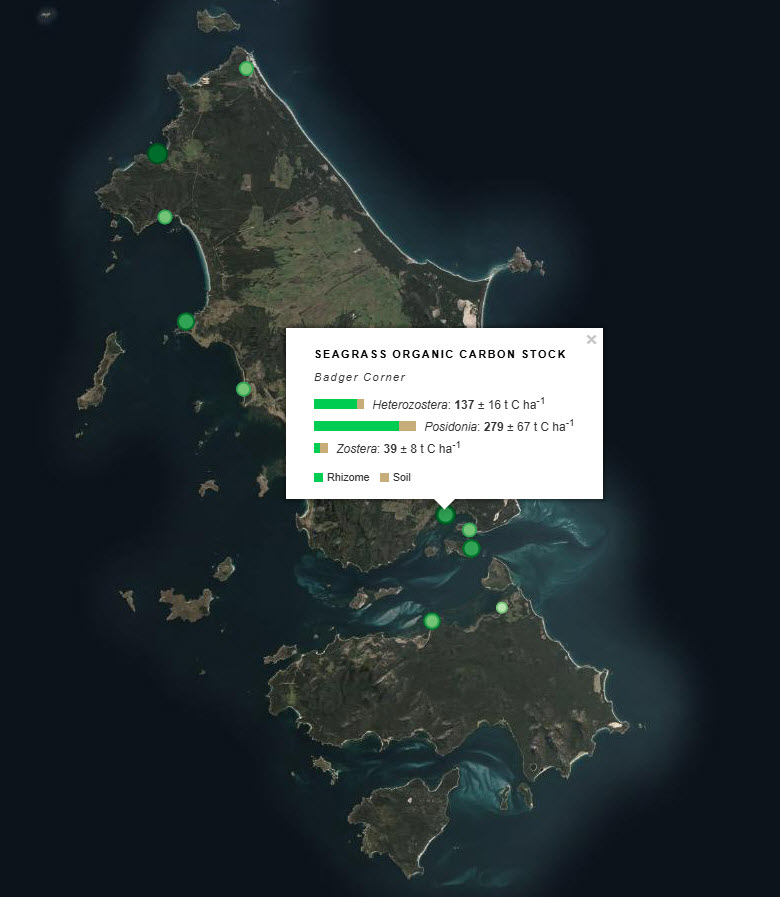
Seagrass beds are a dominant marine ecosystem of Tayaritja (the Furneaux Group of Islands) in the north-eastern waters off Tasmania. Historical coarse mapping has indicated extensive beds of Posidonia, Amphibolis, Heterozostera, and Zostera species, potentially comprising some of the largest and deepest seagrass extents found in temperate Australian waters. However, limited data on the distribution and ecological value of these seagrass habitats represents a significant knowledge gap in understanding Australia's wetland natural assets. This project mapped the extent, ecological composition, population structure, and blue carbon value of seagrass beds around Tayaritja, in partnership with the Tasmanian Aboriginal Centre. This record specifically describes the seagrass-associated blue carbon component of the project, supporting improved understanding of sedimentary carbon storage in the region. Sediment cores were collected from seagrass habitats around Flinders Island to assess spatial variability in carbon stocks and differences among seagrass species. Cores were collected to a maximum depth of 50 cm, or to the boundary between sediment and underlying rock, and were processed to estimate organic carbon stocks in below-ground sediment and plant material. The dataset includes sampling site locations, carbon stock estimates for the upper 50 cm of sediment, and measurements reported by depth interval within the core. At selected sites, samples were sieved to separate roots/rhizomes from the soil fraction, allowing carbon components to be reported separately where available. See the "Lineage" section of this record for full methodology. ***EMBARGO NOTE*** Data is currently embargoed until 31/12/2026. Please contact the NESP Data Wrangler (Southern node) to discuss access options: Emma.Flukes@utas.edu.au
-
Benthic habitat annotations of stereo Baited Remote Underwater Video (Stereo-BRUV) and panoramic drop camera imagery, were completed as part of a report funded by the NESP Marine & Coastal Hub. This report focussed on an IUCN II zone in the South-west Corner Marine Park off the 'Capes region' near Margaret River. These data were analysed in TransectMeasure using a modified version of the CATAMI scheme.