 IMAS Metadata Catalogue
BATHYMETRY
Type of resources
Topics
Keywords
Contact for the resource
Provided by
Years
-

Fine-scale bathymetry mapping was conducted in the Franklin and Zeehan Australian Marine Parks (AMPs) located off the west coast of Tasmania, Australia. The primary objective of this mapping exercise was to map seafloor features of the shelf areas of these AMPs for the first time and to understand the distribution of benthic habitats and key sessile invertebrate species within these areas. Characterisation of the seafloor was undertaken in two phases. The first stage used multibeam sonar to comprehensively map the study areas, extracting bathymetry and backscatter products. This was followed by extensive ground validation undertaken by a panoramic stereo drop-camera system that also recorded the presence of dominant sessile invertebrate fauna as well as benthic/demersal fish species. This record describes and provides data access to the fine-scale substratum mapping extracted from the combination of multibeam bathymetry and video ground-truthing data. Access to the (1) bathymetry survey data; and (2) annotated seafloor imagery, are provided through the 'Download and Links' section of this record.
-
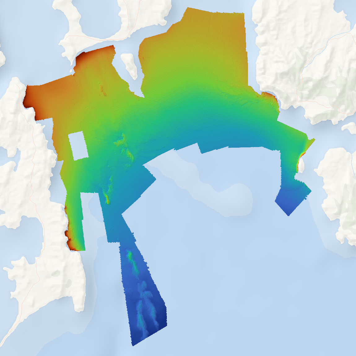
High resolution bathymetry data was collected for Storm Bay, Tasmania as part of the FRDC project 2018-131 'Storm Bay Observing System: Assessing the Performance of Aquaculture Development. Objective 2: Provide a comprehensive map of benthic habitats and bathymetry of the Storm Bay region and assessment of change at key focus areas'. Data is supplied as a single Web Map Service of hillshaded bathymetry for the mapped region. Data is available for download as (1) bathymetry, and (2) hillshade tiff files.
-
Parks Australia - Our Marine Parks Grants Round 2 Project: Nearshore marine habitat mapping of the Norfolk Marine Park (Grant Activity ID: 4-FIZ391E) The Norfolk Marine Park is the is the eastern-most Park in the Temperate East Network of Australian Marine Parks, located between the NSW coast and Norfolk Island. The Park encompasses 188,444 km² of ocean and ranges in depth from 0 m at the Norfolk Island high tide mark to more than 5,00 m off the edge of the Norfolk Ridge. The Park includes two key ecological features – the Norfolk Ridge, and the Tasman Front and associated eddy field – both of which are valued for their high productivity, aggregations of marine life, biodiversity, and endemism. Norfolk Marine Park supports a range of species, including those listed as threatened under the Environment Protection and Biodiversity Conservation (EPBC) Act (1999), and contains Biologically Important Areas for breeding, foraging, and migration of seabirds, marine turtles, and humpback whales. The objective of this project was to create the first marine habitat map for the nearshore shallow water surrounding Norfolk, Nepean, and Phillip Islands. This was conducted in collaboration with Norfolk residents to provide local knowledge input and to ground-truth the remotely-sensed habitat mapping. This high-level habitat map will be used for planning purposes, development applications, and EPBC Act referrals within the nearshore waters of the Norfolk Marine Park, where no specific zoning for recreational and commercial activities currently exists. The map provides a basis for any ongoing citizen-science-driven marine habitat impact and condition assessments, ecosystem monitoring, and to provide the Norfolk Island residents with ownership of any future zoning planning. The map can be further refined as more detailed information becomes available from subject matter experts in the future.
-
This dataset is a compilation product of all publicly available surveyed bathymetry within the Australian Marine Parks (AMPs, 2025 boundaries), merged into a single multi-resolution composite per AMP. The data was compiled by Seamap Australia as part of an Our Marine Parks (Parks Australia) project with funding from the Australian Government to improve knowledge relating to classification of the Australian Marine Parks real estate. This compilation of bathymetry data was the first step in generating geomorphometry classifications (see https://metadata.imas.utas.edu.au/geonetwork/srv/eng/catalog.search#/metadata/40e9283b-d4ed-4176-8fe6-112b8697003f for derived geomorphometry maps). Bathymetry data was collated from AusSeabed data holdings (https://portal.ga.gov.au/persona/marine), the WA Bathymetry Portal (https://dot-wa.maps.arcgis.com/apps/webappviewer/index.html?id=d58dd77d85654783b5fc8c775953c69b), the Australian Ocean Data Network (https://portal.aodn.org.au/) and other existing public data repositories. A single multi-resolution bathymetry mosaic, and associated multi-resolution hillshade mosaic, was generated for each AMP. Data is supplied as a single Web Map Service of bathymetry on hillshade for the mapped regions. Data is available for download as (1) bathymetry, and (2) hillshade, Cloud-Optimised GeoTIFF (COG) files for each AMP. The table below indicates the Parks included in this data package, and the percent coverage of bathymetric data for each. Parks not expressly listed below had no publicly accessible bathymetry data available from the sources listed in the 'lineage' section below. This dataset was last updated on 24/06/2026 and represents all public bathymetry data intersecting AMPs that could be located as of that date. PARK....................................................% COVERAGE Abrolhos...............................................56% Apollo*.................................................100% (63%) Arafura.................................................11% Argo-Rowley Terrace............................34% Arnhem.................................................<1% Ashmore Reef*.....................................100% (68%) Beagle*.................................................100% (56%) Boags*..................................................100% (31%) Bremer..................................................71% Carnarvon Canyon...............................82% Cartier Island*......................................100% (9%) Central Eastern*...................................48% (42%) Christmas Island*.................................44% (41%) Cocos (Keeling) Islands*......................23% (20%) Cod Grounds........................................98% Coral Sea*...........................................100% (32%) Dampier................................................61% East Gippsland.....................................100% Eastern Recherche...............................41% Eighty Mile Beach.................................69% Flinders*...............................................36% (32%) Franklin*...............................................100% (51%) Freycinet*.............................................60% (59%) Gascoyne.............................................67% Geographe...........................................25% Gifford*.................................................100% (70%) Great Australian Bight...........................40% Gulf of Carpentaria................................6% Heard & McDonald Islands*†...............100% (3%) Hunter...................................................90% Huon.....................................................95% Jervis...................................................100% Joseph Bonaparte Gulf*......................100% (0%) Jurien...................................................20% Kimberley*...........................................100% (14%) Lord Howe*..........................................16% (14%) Macquarie Island..................................100% (47%) Mermaid Reef.......................................83% Montebello............................................89% Murray..................................................50% Nelson..................................................62% Ningaloo...............................................55% Norfolk..................................................39% Oceanic Shoals*..................................100% (26%) Perth Canyon......................................100% Roebuck..............................................100% Shark Bay............................................16% Solitary Islands....................................100% Southern Kangaroo Island.....................4% South Tasman Rise..............................82% South-west Corner...............................53% Tasman Fracture..................................99% Twilight.................................................1% Two Rocks...........................................34% Wessel..................................................1% West Cape York*..................................100% (11%) Western Eyre........................................27% Western Kangaroo Island.....................6% Zeehan.................................................73% * indicates Digital Elevation Model (DEM) data was included in compilation. Coverage of surveyed (non-modelled) bathymetry is shown in parentheses () † has been included in analysis but is not an Australian Marine Park
-
The Seamap Australia National Benthic Habitat Layer (NBHL) is a nationally synthesised database of seafloor habitat data, classified according to the Seamap Australia National Benthic Habitat Classification Scheme (https://vocabs.ardc.edu.au/viewById/129). In generating the Seamap Australia NBHL, datasets from data providers around Australia are collated and centrally hosted by IMAS (UTAS). Through time, some datasets become superseded by newer, more accurate data for the same region (improved data collection or processing methodology). This record aggregates all habitat datasets that have been collated as part of the Seamap Australia project, but are no longer considered the most accurate/up to date habitat for a particular region and have been superseded by another product. The parent record for the Seamap Australia NBHL provides an aggregation point for all "current" habitat datasets: https://metadata.imas.utas.edu.au/geonetwork/srv/eng/catalog.search#/metadata/4739e4b0-4dba-4ec5-b658-02c09f27ab9a
-

The Seamap Australia National Benthic Habitat Layer (NBHL) is a compilation of benthic habitat datasets obtained from various sectors including research, government, industry and community sources, across Australia. Disparate datasets are integrated into a single national-scale benthic habitat database, and classified uniformly under a national classification scheme implemented as a controlled vocabulary (https://vocabs.ardc.edu.au/viewById/129). For acceptance into the 'formal' (validated_ Seamap Australia NBHL (see https://metadata.imas.utas.edu.au/geonetwork/srv/eng/catalog.search#/metadata/4739e4b0-4dba-4ec5-b658-02c09f27ab9a), source habitat datasets must meet a set of Acceptance Criteria (documented in https://seamapaustralia.org/wp-content/uploads/2023/01/SeamapAustraliaDataAcceptanceGuidelines.pdf). Broadly speaking, for inclusion in the Seamap Australia NBHL, datasets must: (1) be well-described by metadata or associated documentation; (2) employ a single, consistent classification scheme which avoids non-deterministic or ambiguous terms; (3) bequality-controlled by the provider prior to contribution; (4) beacquired using an established and community-endorsed form of data collection (eg satellite, aerial or acoustic remote sensing); and (5) have documented evidence of ground-truthing validation at the time of data collection (e.g. drop camera, towed video, benthic grabs). This record describes habitat datasets that meet Acceptance Criteria 1-4, but *have not* been validated/ground-truthed and are therefore ineligible for inclusion in the formal Seamap Australia NBHL. They have been synthesised and uniformly classified using an identical methodology to the NBHL, but represent an intermediate collection of habitat datasets that would benefit from field ground-truthing in order to validate the habitat classifications. The Seamap Australia synthesis of unvalidated habitat datasets can be viewed, analysed and downloaded from the Seamap Australia data portal (https://seamapaustralia.org/map). This dataset should be considered a “live” asset and will continue to develop as more unvalidated habitat datasets are collected or made available. The most current (2024) version of the data is available from the following endpoints: WMS: https://geoserver.imas.utas.edu.au/geoserver/seamap/wms WFS: https://geoserver.imas.utas.edu.au/geoserver/seamap/wfs Layer name: SeamapAus_NBHL_unvalidated Various download options are supplied in the “Online resources” section of this record.
-

This dataset is a mosaicked product of all publicly available bathymetry data within the Australian Exclusive Economic Zone (EEZ). The data package consists of 8x bathymetry mosaics (and associated bathymetry derivatives: hillshade, slope, aspect) for each of the 8x Parks Australia Management Effectiveness Ecosystem Component depth zones ("Ecosystem Zones"). The grid resolution of the mosaics has been guided by the depth gridding recommendations of the AusSeabed Australian Multibeam Guidelines (2020) to produce the following mosaics: • shallow zone (0-30m): 10m resolution • mesophotic zone (30-70m): 10m resolution • rariphotic zone (70-200m): 10m resolution • upper-slope zone (200-700m): 32m resolution • mid-slope zone (700-2,000m): 64m resolution • lower-slope zone (2,000-4,000m): 128m resolution • abyss zone (4,000-6,000m): 210m resolution • hadal zone (>6,000m): 210m resolution A systematic prioritisation approach was used to preferentially use newer, high-resolution, and cleaner bathymetry inputs from remote sensing (multibeam, singlebeam, satellite, seismic etc), with Digital Elevation Models (DEM) used as foundational data in regions where survey data was not available. This approach optimised spatial resolution by preserving higher resolutions in shallower waters as supported by the data, while also ensuring the output datasets remain manageable for downstream applications. The result is suite of depth-stratified bathymetry mosaics and associated derivatives that provide full coverage of Australia's marine estate (clipped to the boundaries of the Australian Exclusive Economic Zone (EEZ)). All publicly available bathymetry data as at July 2024 for was included. Data can be visualised and used in GIS packages as maps of hillshaded bathymetry and hillshaded slope at the following WMS endpoints: • bathymetry: https://geoserver.imas.utas.edu.au/geoserver/bathy_composites/AusEEZ_bathy_composite_multires/wms?request=GetCapabilities&service=WMS • hillshade: https://geoserver.imas.utas.edu.au/geoserver/bathy_composites/AusEEZ_bathy_hillshade_composite_multires/wms?request=GetCapabilities&service=WMS • slope: https://geoserver.imas.utas.edu.au/geoserver/bathy_composites/AusEEZ_bathy_slope_composite_multires/wms?request=GetCapabilities&service=WMS • aspect: https://geoserver.imas.utas.edu.au/geoserver/bathy_composites/AusEEZ_bathy_aspect_composite_multires/wms?request=GetCapabilities&service=WMS • aspect-slope (for mapping applications only): https://geoserver.imas.utas.edu.au/geoserver/bathy_composites/AusEEZ_bathy_aspectSlope_composite_multires/wms?request=GetCapabilities&service=WMS Data is available for download in the following packages (each structured as 8x mosaics for each Ecosystem Zone at the gridding resolution specified above): (1) bathymetry composites; (2) hillshade composites; (3) slope composites; (4) aspect composites. An ancillary Shapefile footprint index file is also available showing the source data used in generating each region of the mosaics. Note that minimal cleaning of input data was conducted, and no attempt was made to smooth or blend the transitions between swath edges, or between swaths and the underlying DEMs. Consequently, noise and edge effects between adjacent input data may be visible. This should be considered when interpreting the data, and the data should not be used for navigational purposes. See the Lineage section of this record for full methodology.
-

The Seamap Australia National Benthic Habitat Layer (NBHL) is a compilation of benthic habitat datasets obtained from various sectors including research, government, industry and community sources, across Australia. These disparate datasets have been integrated into a single national-scale benthic habitat database, and classified uniformly under a national classification scheme implemented as a controlled vocabulary (https://vocabs.ardc.edu.au/viewById/129). Creation of this classification scheme complements work undertaken by the National Environmental Science Program (NESP) Marine Biodiversity Hub (Theme D). For acceptance into the Seamap Australia NBHL, source habitat datasets must meet a set of Acceptance Criteria (documented in https://seamapaustralia.org/wp-content/uploads/2023/01/SeamapAustraliaDataAcceptanceGuidelines.pdf). Broadly speaking, for inclusion in the Seamap Australia NBHL, datasets must: (1) be well-described by metadata or associated documentation; (2) employ a single, consistent classification scheme which avoids non-deterministic or ambiguous terms; (3) be quality-controlled by the provider prior to contribution; (4) beacquired using an established and community-endorsed form of data collection (eg satellite, aerial or acoustic remote sensing); and (5) have documented evidence of ground-truthing validation at the time of data collection (e.g. drop camera, towed video, benthic grabs). The Seamap Australia NBHL can be viewed, analysed and downloaded from the Seamap Australia data portal (https://seamapaustralia.org/map) – a national repository of seafloor habitat data and a decision support tool for marine managers. All habitat datasets in the Seamap Australia data portal, including the NBHL and all local- to regional-scale contributing datasets, are available for download. The Seamap Australia NBHL is a data collection of national importance and highlights the diversity of benthic habitats across Australia’s marine estate. This is the first Australian habitat dataset that seamlessly consolidates data from each of Australia’s state and territory providers. This dataset should be considered a “live” asset and will continue to develop as more suitable validated habitat data becomes available for inclusion, and improvements in data collection and analysis techniques enhance its resolution and currency. The most current (2026) version of the data is available from the following endpoints: WMS: https://geoserver.imas.utas.edu.au/geoserver/seamap/wms WFS: https://geoserver.imas.utas.edu.au/geoserver/seamap/wfs Layer name: SeamapAus_National_Benthic_Habitat_Layer A download link for the full dataset is supplied in the 'Download and Links' section of this record, along with download links to older versions of the dataset. Note that data is now only available in Geodatabase (.gdb) format as it exceeds Shapefile size limits.
-
This dataset has been superseded by https://metadata.imas.utas.edu.au/geonetwork/srv/eng/catalog.search#/metadata/0145df96-3847-474b-8b63-a66f0e03ff54 (Victorian Statewide Marine Habitat Map 2023). The Victorian Benthic Habitats - Western Port Bay (CBICS) is a synthesis of all existing benthic habitat characterisations of the embayment which have been reclassified to conform to the Combined Biotope Classification Scheme (CBiCS). Base layers for the synthesised dataset were sourced from data provided by: Marine and Freshwater Resources Institute, Queenscliff, Victoria Institute for Sustainability and Innovation, Victoria University, Melbourne. Parks Victoria, Victorian Government Deakin University, Victoria Department of Environment, Land, Water and Planning, Victorian Government
-
This dataset has been superseded by https://metadata.imas.utas.edu.au/geonetwork/srv/eng/catalog.search#/metadata/0145df96-3847-474b-8b63-a66f0e03ff54 (Victorian Statewide Marine Habitat Map 2023). The Victorian Benthic Habitats - Gippsland Lakes (CBICS) is a synthesis of all existing benthic habitat characterisations of the Gippsland Lakes Region which have been reclassified to conform to the Combined Biotope Classification Scheme (CBiCS). The study area for this layer is defined as Jack Smith Lake in the west to Mallacoota in the east.