 IMAS Metadata Catalogue
BENTHIC
Type of resources
Topics
Keywords
Contact for the resource
Provided by
Years
-
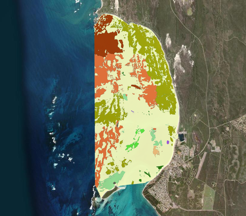
Mapping of benthic habitat and seafloor bathymetry of Lancelin, WA derived from satellite imagery captured on 17 July 2017 at a spatial resolution of 2 m. Mapping extent covered as much of the Defence gazetted waters as possible, to a depth of approximately 18 m based on water clarity. Recently dead or senesced (e.g. winter dieback of leaves) and mobile seagrass have the same satellite signature as live seagrass at spectral resolutions of the sensor (WorldView-2). This ensured areas of winter dieback and/or senescence were captured as areas of seagrass for the purposes of impact assessment.
-
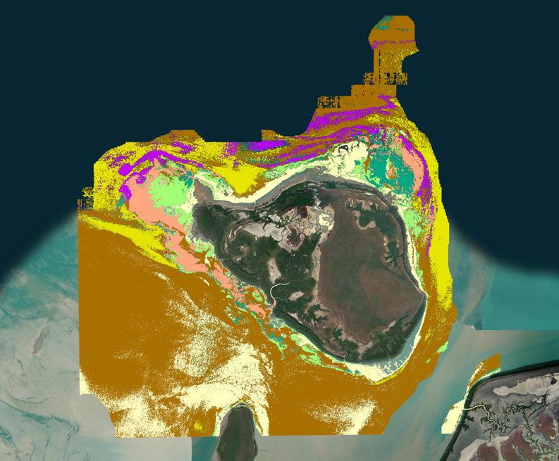
Jurien Bay Boat Harbour is located north of the town of Jurien Bay, ~250 km north of Perth, Western Australia. The Boat Harbour services a range of government, recreational and commercial vessels and is managed by the WA Department of Transport (DoT). Wrack and marine sediments frequently accumulate in the Boat Harbour, negatively affecting the navigability, environment and aesthetic quality of the Harbour. To manage these impacts, routine maintenance dredging is undertaken by DoT. To inform future dredging requirements and marine environmental management of the Boat Harbour, BMT undertook benthic habitat mapping of Jurien Bay in November 2017 on behalf of DoT. The objectives of the mapping project were to: i. collect baseline data on the spatial extent and characteristics of benthic habitats in the mapping area, and ii. qualitatively characterise the extent of benthic primary producer habitat surrounding the Boat Harbour, and develop a mapping product to inform dredging operations and potential future environmental approvals applications, if necessary. Mapping was conducted by first collating satellite imagery to identify benthic habitat features to be ground-truthed by towed video. Video footage was annotated with biological attributes and combined with the satellite imagery to create classified benthic habitat maps of an area offshore of the Boat Harbour. See the "Lineage" section of this record and attached survey report for detailed methodology.
-
Green turtles (Chelonia mydas) are globally endangered and culturally significant to Indigenous Traditional Owners in northern Australia, yet fine-scale understanding of their foraging habitats remains poorly understood, especially along Australia's remote north-coast. This project mapped green turtle foraging habitats in the Northern Territory, through collaboration with Indigenous Traditional Owners and ranger groups, to assist with their sea country management. Visual classifications of towed video transect data were used in a Support Vector Machine Learning Model to predict habitat in 379 km² of remotely sensed satellite imagery, overlapping the benthic habitats for two green turtle foraging grounds within the joint managed parks: Trepang Bay, Garig Gunak Barlu Marine Park, and Field Island, Kakadu National Park. Algae and seagrass made up 30% of the Trepang Bay and 18.05% of the Field Island foraging turtle habitat. The classification accuracy of the model showed a high level of agreement at both sites (0.63 for Trepang Bay and 0.75 for Field Island). These habitats provide good foraging grounds for green turtles and the diversity of marine habitats also allows for a range of different age classes of green turtles to use these sites for a range of other behaviours, e.g. resting and predator avoidance. The simplicity and repeatability of the field methods used in this study allow for future monitoring of marine habitats in remote areas by ranger groups. The findings are useful for conservation planning, including the development of management plans in the Northern Territory.
-
This dataset compiles spatial environmental data layers from various sources used for predicting distributional patterns of Antarctic seafloor biodiversity (Jansen et al, in prep). All data layers are projected to polar stereographic (EPSG:3031) at a resolution of 2km. Data layers include seafloor depth, slope and topographic position index, distance to the nearest underwater canyon head, ocean surface net primary productivity, seafloor water current speeds, temperature and salinity, and modelled availability of ocean surface-derived food at the seafloor.
-
Mapping of benthic habitat and seafloor bathymetry of Swanbourne, WA derived from satellite imagery captured on 03 June 2017 at a spatial resolution of 2 m. Mapping extent covered as much of the Defence gazetted waters as possible, to a depth of approximately 18 m based on water clarity. Recently dead or senesced (e.g. winter dieback of leaves) and mobile seagrass have the same satellite signature as live seagrass at spectral resolutions of the sensor (WorldView-2). This ensured areas of winter dieback and/or senescence were captured as areas of seagrass for the purposes of impact assessment.
-
The coral reefs of Australia’s North West Kimberley Bioregion are both unique and internationally significant. They exist in one of the most extreme marine environments globally, characterised by the highest tidal range in the southern hemisphere, persistent turbidity, and frequent cyclones. These conditions have shaped coral reefs with distinct geomorphological attributes. The region’s remoteness has minimised direct anthropogenic pressures, but it also presents substantial logistical and financial challenges for data collection and fieldwork. To improve access to information about this region, a geodatabase termed 'ReefKIM' was developed. ReefKIM integrates diverse datasets into a single, comprehensive repository to support research and management. Sources include satellite imagery, orthophotos, bathymetric charts, sub-bottom profiles, geological maps, seabed geomorphology, reef cores, biophysical data, and extensive ground-truthing. This enabled consistent derivation of six broad feature classes: (1) reef extents (2) geomorphological zones (3) habitats and substrates (4) coastlines (5) island boundaries; and (6) other studies and work (e.g. ground truth points, survey, sample collections, coring sites, sub-bottom profiles, images) This record provides access to items (1), (2) and (3) of the ReefKIM components, collated for the purposes of the Seamap Australia National Benthic Habitat Mapping collaborative project. • Reef extents: 853 reef features with size, shape, and reef type attributes. • Geomorphological zones: Five standardised reef zones (land, reef flat, lagoon, reef crest, and fore-reef slope) mapped for 30 reefs. • Habitats and substrates: Seven habitat/substrate classes (mangroves, sand, seagrass and algae, coral rubble, reef pavement with algal turf, crustose coralline algae, and coral communities) mapped for 30 islands and reefs. Additional ReefKIM products are stored at the Pawsey Supercomputing Centre under: WA Node Ocean Data Network > WAMSI2 > KMRP > 1.3 > 1.3.1 A full directory is documented in '1.3.1_Folder_Structure.pdf' in 1.3.1>001_Metadata at https://storage.pawsey.org.au/public/projects
-
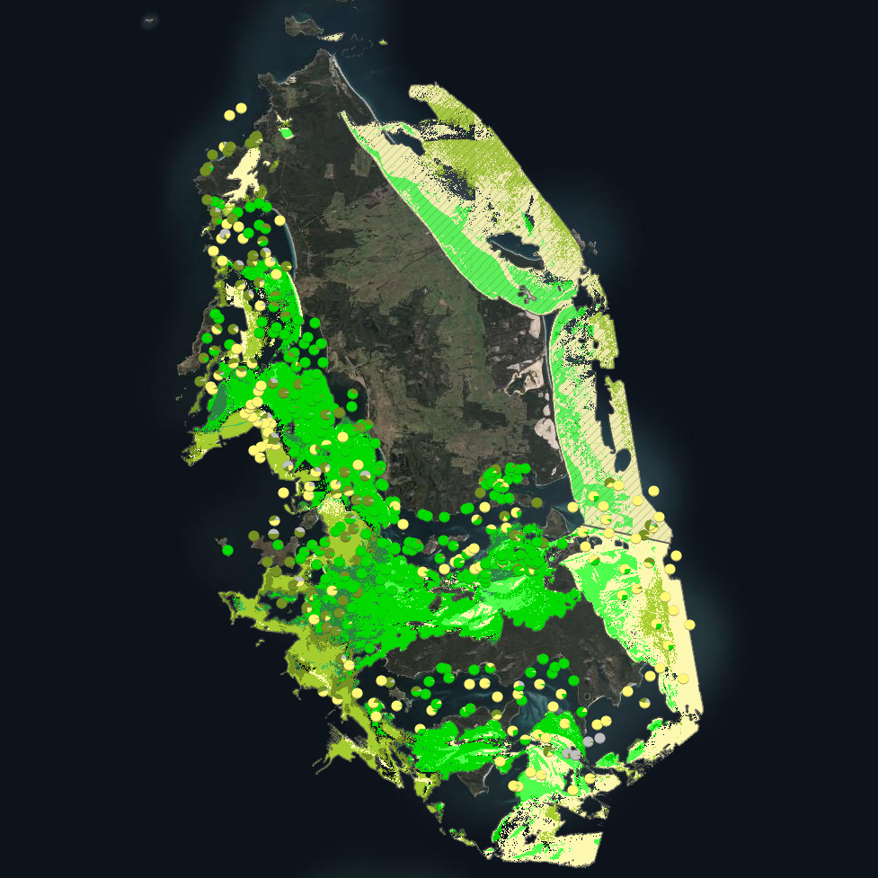
***This record contains a subset of benthic habitat data from https://doi.org/10.25959/E4S6-GE74 (NESP MaC Project 3.6) rehosted for the purposes of the Seamap Australia collaborative project.*** Seagrass beds are a dominant marine ecosystem of Tayaritja (the Furneaux Group of Islands) in the north-eastern waters off Tasmania. Historical coarse mapping has indicated extensive beds of Posidonia, Amphibolis, Heterozostera, and Zostera species, potentially comprising some of the largest and deepest seagrass extents found in temperate Australian waters. However, limited data on the distribution and ecological value of these seagrass habitats represents a significant knowledge gap in understanding Australia's wetland natural assets. This project mapped the extent, ecological composition, population structure, and blue carbon value of seagrass beds around Tayaritja, in partnership with the Tasmanian Aboriginal Centre, as part of NESP Marine and Coastal Hub Project 3.6. The study area focused on the coastal waters surrounding Flinders Island in the western Furneaux Group, with mapping extending from the high tide line to the depth limit of reliable optical detection (approximately 30 m), based on analysis of field data and satellite imagery capabilities in the region. This metadata record specifically describes the benthic mapping component of the study. A combination of close-range remote sensing methods was used to map the extent and ecological values of seagrass beds. High-resolution satellite imagery from Sentinel-2 (10 m) sensors, combined with bathymetric LiDAR data and oceanographic variables, was used to map baseline seagrass extent and composition. A field campaign deployed a Benthic Observation Survey System (BOSS) and unBaited Remote Underwater stereo-Video system (stereo-uBRUV) at approximately 400 locations to validate remote sensing outputs, collecting field photo quadrats and rhizome cores. From these data, maps were produced showing the extent and coverage of seagrass, sand, and macroalgae, and where possible, seagrass species composition, subject to water depth and clarity constraints. See the "Lineage" section of this record for full methodology.
-
This data is from the 2021 'Seeds for Snapper' season which is a community volunteer seed based seagrass restoration program located in Perth, Western Australia. It details the effort that went into the collection of Posidonia australis seagrass fruit including number of divers, number of shore support personnel, volunteered hours, and fruit collection metrics (volume, estimated number).
-

Seagrass beds are a dominant marine ecosystem of Tayaritja (the Furneaux Group of Islands) in the north-eastern waters off Tasmania. Historical coarse mapping has indicated extensive beds of Posidonia, Amphibolis, Heterozostera, and Zostera species, potentially comprising some of the largest and deepest seagrass extents found in temperate Australian waters. However, limited data on the distribution and ecological value of these seagrass habitats represents a significant knowledge gap in understanding Australia's wetland natural assets. This project mapped the extent, ecological composition, population structure, and blue carbon value of seagrass beds around Tayaritja, in partnership with the Tasmanian Aboriginal Centre. The study area focused on the coastal waters surrounding Flinders Island in the western Furneaux Group, with mapping extending from the high tide line to the depth limit of reliable optical detection (approximately 30 m), based on analysis of field data and satellite imagery capabilities in the region. This record specifically describes the benthic mapping component of the study. See https://doi.org/10.25959/WRXK-KV06 for imagery annotation data from the field validation campaigns. A combination of close-range remote sensing methods was used to map the extent and ecological values of seagrass beds. The approach developed through this study contributed to the creation of the NESP Standard Operating Procedure (SOP) for Seagrass Mapping using Optical Remote Sensing (https://sustainabledevelopmentreform.github.io/nesp-sop-seagrass-mapping).. High-resolution satellite imagery from Sentinel-2 (10 m) sensors, combined with bathymetric LiDAR data and oceanographic variables, was used to map baseline seagrass extent and composition. A field campaign deployed a Benthic Observation Survey System (BOSS) and unBaited Remote Underwater stereo-Video system (stereo-uBRUV) at approximately 400 locations to validate remote sensing outputs. From these data, maps were produced showing the extent and coverage of seagrass, sand, and macroalgae, and where possible, seagrass species composition, subject to water depth and clarity constraints. See the "Lineage" section of this record for full methodology. Three key types of mapping products were developed: ---Occurrence probability maps--- Continuous probability surfaces (0-100%), modelled from presence/absence data, indicating the likelihood of habitat presence at each pixel for: • Seagrass (all morphologies; > 5% cover observed in underwater field imagery) • Macroalgae species/assemblages • Sand ---Habitat percentage cover maps--- Quantitative estimates of percent cover for each habitat category: • Seagrass (all morphologies) • Macroalgae species/assemblages • Sand ---Derived products--- • Baseline binary presence/extent maps derived from optimised probability thresholds: ○ Seagrass: sgprob > 0.5 & sgprob > macroprob & sandcover < 0.9 ○ Macroalgae: macroprob > 0.5 & macroprob > sgprob & sandcover < 0.9 ○ Sand: sandprob > 0.5 & sandcover < 0.2 • Predicted seagrass species composition of binary extent map. • Fractional cover visualisation: combining cover percentages of multiple habitats into a single composite product • Composite habitat maps: combining binary habitat extents and delineating mixed habitat classes These complementary products serve different purposes: probability maps provide confidence measures, extent maps delineate habitat boundaries, percent cover maps support quantitative analysis of habitat density patterns, and composite habitat maps represent the diversity of mixed habitat classes. Together, they provide a comprehensive understanding of seagrass and associated habitat distribution across the study area.
-
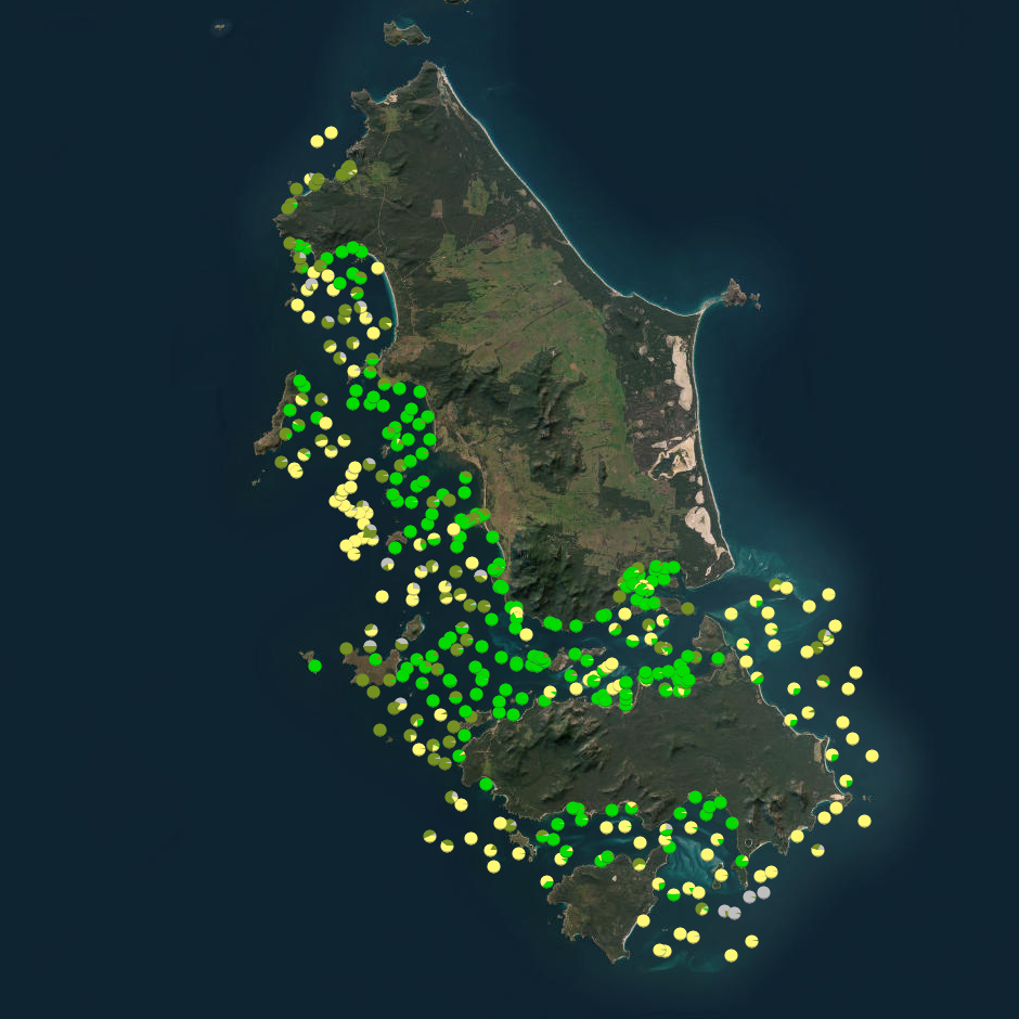
Seagrass beds are a dominant marine ecosystem of Tayaritja (the Furneaux Group of Islands) in the north-eastern waters off Tasmania. Historical coarse mapping has indicated extensive beds of Posidonia, Amphibolis, Heterozostera, and Zostera species, potentially comprising some of the largest and deepest seagrass extents found in temperate Australian waters. However, limited data on the distribution and ecological value of these seagrass habitats represents a significant knowledge gap in understanding Australia's wetland natural assets. This project mapped the extent, ecological composition, population structure, and blue carbon value of seagrass beds around Tayaritja. The study area focused on the coastal waters surrounding Flinders Island in the western Furneaux Group, with mapping extending from the high tide line to the depth limit of reliable optical detection (approximately 30 m), based on analysis of field data and satellite imagery capabilities in the region. The field validation component of this study involved deployment of benthic video platforms to capture imagery of seagrass beds and associated ecosystems. A field campaign deployed a Benthic Observation Survey System (BOSS) and unBaited Remote Underwater stereo-Video system (stereo-uBRUV) at approximately 400 locations to collect photoquadrats and validate remote sensing outputs. Imagery annotation was conducted in the SQUIDLE+ platform. The approach developed through this study contributed to the creation of the NESP Standard Operating Procedure (SOP) for Seagrass Mapping using Optical Remote Sensing (https://sustainabledevelopmentreform.github.io/nesp-sop-seagrass-mapping).. See the "Lineage" section of this record for full methodology of field collection techniques. See associated dataset https://doi.org/10.25959/e4s6-ge74 for habitat maps derived from field validation and remote sensing inputs.