 IMAS Metadata Catalogue
Mapping of temperate subtidal seagrass beds in Tayaritja Sea Country (Furneaux Group of Islands), Lutruwita (Tasmania)
***This record contains a subset of benthic habitat data from https://doi.org/10.25959/E4S6-GE74 (NESP MaC Project 3.6) rehosted for the purposes of the Seamap Australia collaborative project.***
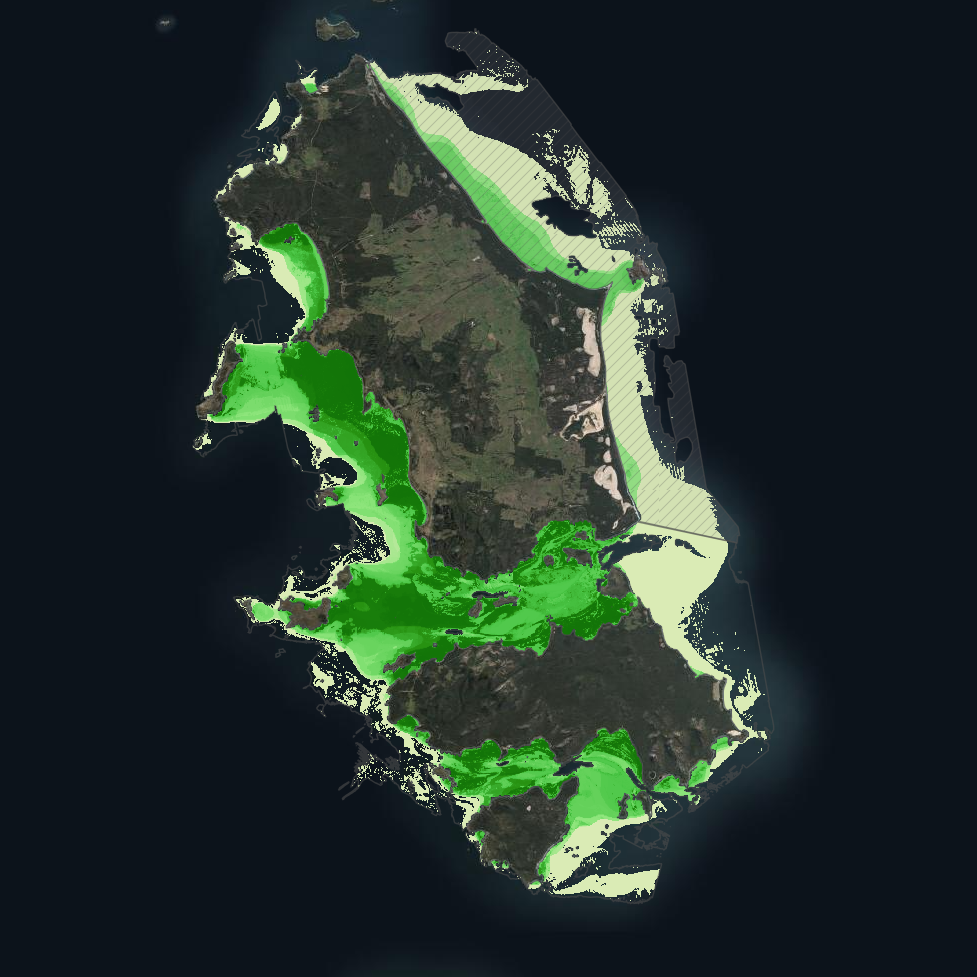
Seagrass beds are a dominant marine ecosystem of Tayaritja (the Furneaux Group of Islands) in the north-eastern waters off Tasmania. Historical coarse mapping has indicated extensive beds of Posidonia, Amphibolis, Heterozostera, and Zostera species, potentially comprising some of the largest and deepest seagrass extents found in temperate Australian waters. However, limited data on the distribution and ecological value of these seagrass habitats represents a significant knowledge gap in understanding Australia's wetland natural assets.
This project mapped the extent, ecological composition, population structure, and blue carbon value of seagrass beds around Tayaritja, in partnership with the Tasmanian Aboriginal Centre, as part of NESP Marine and Coastal Hub Project 3.6. The study area focused on the coastal waters surrounding Flinders Island in the western Furneaux Group, with mapping extending from the high tide line to the depth limit of reliable optical detection (approximately 30 m), based on analysis of field data and satellite imagery capabilities in the region. This metadata record specifically describes the benthic mapping component of the study.
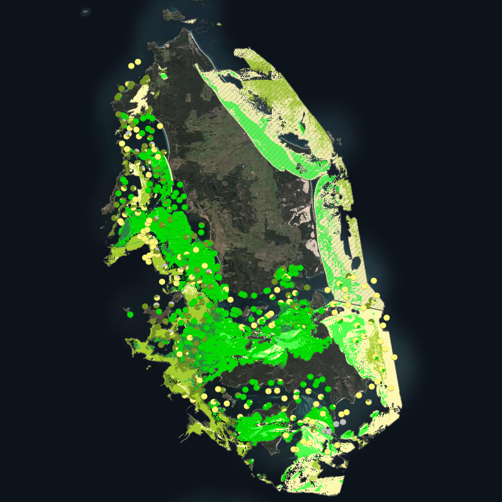
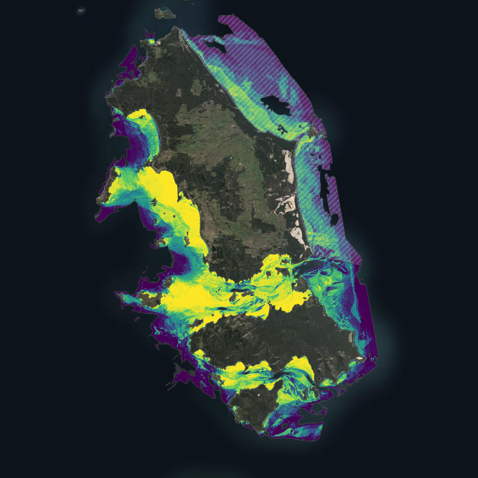
A combination of close-range remote sensing methods was used to map the extent and ecological values of seagrass beds. High-resolution satellite imagery from Sentinel-2 (10 m) sensors, combined with bathymetric LiDAR data and oceanographic variables, was used to map baseline seagrass extent and composition. A field campaign deployed a Benthic Observation Survey System (BOSS) and unBaited Remote Underwater stereo-Video system (stereo-uBRUV) at approximately 400 locations to validate remote sensing outputs, collecting field photo quadrats and rhizome cores. From these data, maps were produced showing the extent and coverage of seagrass, sand, and macroalgae, and where possible, seagrass species composition, subject to water depth and clarity constraints.
See the "Lineage" section of this record for full methodology.
Simple
Identification info
- Date (Creation)
- 2022-07-01
Principal investigator
Collaborator
Collaborator
Collaborator
Collaborator
Collaborator
Collaborator
Collaborator
Collaborator
- Status
- Completed
Point of contact
Point of contact
- Topic category
-
- Biota
Extent

Temporal extent
- Time period
- 2020-01-01 2023-12-31
Vertical element
- Minimum value
- 0
- Maximum value
- 30
- Identifier
- EPSG::5715
- Name
- MSL depth
- Maintenance and update frequency
- Not planned
Resource format
- Date
- GCMD Earth science Keywords
Resource constraints
- Classification
- Unclassified
Resource constraints
- Linkage
-
http://i.creativecommons.org/l/by/4.0/88x31.png
License Graphic
- Title
- Creative Commons Attribution 4.0 International License
- Website
-
http://creativecommons.org/licenses/by/4.0/
License Text
- Other constraints
- Cite data as: Lucieer, V., Ierodiaconou, D., Strain, E., Wright, J., Hulls, J., Flukes, E., Carnell, P., Dalby, O., Sherman, C., Lyons, M., & Cozens, Z. (2025). Mapping of subtidal temperate seagrass beds in Tayaritja (Furneaux group of islands), north-eastern Tasmania [Data set]. Institute for Marine and Antarctic Studies. Data accessed at https://metadata.imas.utas.edu.au/geonetwork/srv/eng/catalog.search#/metadata/9353d4a3-c003-40f4-a747-bf0246f01014 on [access date[.
- Other constraints
- This dataset is hosted by the Institute for Marine and Antarctic Studies (IMAS), University of Tasmania, on behalf of NESP Marine and Coastal Hub Project 3.6 for the purposes of the Seamap Australia collaborative project.
Associated resource
- Title
- NESP Marine and Coastal Hub Project 3.6
Identifier
- Code
- 10.25959/E4S6-GE74
- Codespace
- doi.org
- Association Type
- Cross reference
- Initiative Type
- Study
- Language
- English
- Character encoding
- UTF8
Distribution Information
- Distribution format
-
- Geotiff
- OnLine resource
- DATA ACCESS - composite habitat map raster
- OnLine resource
- DATA ACCESS - percent cover rasters for each habitat class
- OnLine resource
- DATA ACCESS - raw detection products (multiband probability and % cover for all habitat classes)
- OnLine resource
-
SHAPE-ZIP
DATA ACCESS - Tayaritja subtidal seagrass mapping (Shapefile version)
- OnLine resource
-
SeamapAus_TAS_Furneaux_seagrass_2024_MAP
MAP - combined benthic habitat map of Tayaritja
- OnLine resource
-
MaC_3_6_Furneaux_fractionalcover
MAP - fractional cover of broad habitat classes of Tayaritja
- OnLine resource
-
MaC_3_6_Furneaux_proboccurrence_seagrass_mask
MAP - seagrass probability of occurrence of Tayaritja
- OnLine resource
-
MaC_3_6_Furneaux_perccover_seagrass_mask
MAP - seagrass % cover of Tayaritja
- OnLine resource
- Standard Operating Procedure for Seagrass Mapping using Optical Remote Sensing: NESP 3.6 Case Study
- OnLine resource
- Original metadata record
Resource lineage
- Statement
- ----Field Data Collection---- Field data collection followed the protocols outlined in Section 5 of the Seagrass Mapping SOP (https://sustainabledevelopmentreform.github.io/nesp-sop-seagrass-mapping/#5-training-data-collection-and-curation), utilising a statistically balanced sampling approach that maintained uniform sampling intensity while avoiding preference or exclusion of any areas. Two stereo-video platforms were used to ground-truth habitat data in this study: the unBaited Remote Underwater stereo-Video system (stereo-uBRUV) and the Benthic Observation Sampling System (BOSS). Stereo-uBRUVs are a widely accepted method for surveying benthic fish communities, consisting of a pair of horizontally-facing cameras mounted inside a trapezoidal frame, which is deployed to the seafloor, typically for a period of ~1 hour. The BOSS system (https://drop-camera-field-manual.github.io) is a newer platform designed for rapid assessment of benthic communities, capturing detailed benthic habitat information in a single 3-5 minute deployment. It uses four horizontally-facing cameras mounted at 90 degree angles and captures a ~270° downwards-facing view, generating high-resolution panoramic imagery of the seafloor. The CATAMI classification scheme was used for benthic feature labeling, with points annotated using the Squidle+ platform (https://squidle.org). For both methods, additional metadata such as deployment location, water depth, date, and time were recorded. All deployments followed standard operating procedures outlined in the national marine sampling field manuals (https://marine-sampling-field-manual.github.io). All imagery is publicly accessible at SQUIDLE+: https://squidle.org/geodata/explore/img?filters={"campaign_ids":[967,1106,1138]} ---Satellite Imagery--- Sentinel-2 multispectral imagery from 01-01-2020 to 31-12-2023 was used to create multi-temporal stacks. Clouds were masked using Google Cloud Score Plus. Composite images were produced using percentile metrics (20th, 40th, 60th, 80th) ---Environmental Data Sources--- Several ancillary data sources were integrated to provide information on water depth (influences light availability) and improve classification accuracy: • High-resolution LiDAR bathymetry from surveys conducted for the Australian Hydrographic Office • Lower-resolution LiDAR and sonar bathymetry to fill gaps in the primary dataset • Derived products including slope and rugosity at multiple scales • Wavewatch III wave hindcast model (metrics included average wave power, maximum wave power, standard deviation) Data was then interpolated to create a uniform grid with appropriate spatial resolution for the study area. ---Classification Approach--- A Boosted Regression Tree machine learning algorithm was selected for its effectiveness with complex environmental data, with parameters optimised for this study. The classification approach consisted of three main steps: • Probabilistic Classification: Generation of a continuous probability (from classification trees) surface indicating the likelihood of seagrass (+ macroalgae/sand) presence at each pixel • Habitat percent cover regression: Generation of continuous percentage cover estimates (from regression trees) indicating cover of seagrass (+ macroalgae/sand) in each pixel • Threshold Selection and Extent Mapping: Determination of a probability threshold, combining with information from other modelled products and manual editing boundaries, to define a baseline seagrass extent See 3.6 Case Study SOP (https://sustainabledevelopmentreform.github.io/nesp-sop-seagrass-mapping/case_study_NESP3.6/NESP_3.6_case_study.html) for a full description of the modelling approach and associated code.
- Hierarchy level
- Dataset
Metadata
- Metadata identifier
- urn:uuid/9353d4a3-c003-40f4-a747-bf0246f01014
- Language
- English
- Character encoding
- UTF8
Point of contact
- Parent metadata
Type of resource
- Resource scope
- Dataset
- Metadata linkage
-
https://metadata.imas.utas.edu.au/geonetwork/srv/eng/catalog.search#/metadata/9353d4a3-c003-40f4-a747-bf0246f01014
Point of truth URL of this metadata record
- Date info (Creation)
- 2015-05-06T11:44:25
- Date info (Revision)
- 2026-06-27T10:45:55
Metadata standard
- Title
- ISO 19115-3:2018
Overviews
Spatial extent

Provided by
