 IMAS Metadata Catalogue
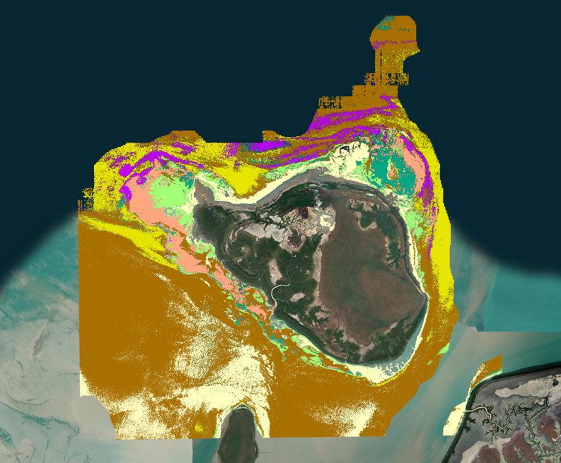
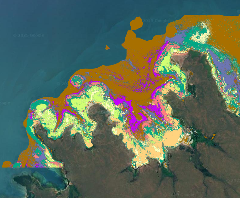
NT mapping of green turtle foraging habitat
Green turtles (Chelonia mydas) are globally endangered and culturally significant to Indigenous Traditional Owners in northern Australia, yet fine-scale understanding of their foraging habitats remains poorly understood, especially along Australia's remote north-coast. This project mapped green turtle foraging habitats in the Northern Territory, through collaboration with Indigenous Traditional Owners and ranger groups, to assist with their sea country management.
Visual classifications of towed video transect data were used in a Support Vector Machine Learning Model to predict habitat in 379 km² of remotely sensed satellite imagery, overlapping the benthic habitats for two green turtle foraging grounds within the joint managed parks: Trepang Bay, Garig Gunak Barlu Marine Park, and Field Island, Kakadu National Park.
Algae and seagrass made up 30% of the Trepang Bay and 18.05% of the Field Island foraging turtle habitat. The classification accuracy of the model showed a high level of agreement at both sites (0.63 for Trepang Bay and 0.75 for Field Island). These habitats provide good foraging grounds for green turtles and the diversity of marine habitats also allows for a range of different age classes of green turtles to use these sites for a range of other behaviours, e.g. resting and predator avoidance.
The simplicity and repeatability of the field methods used in this study allow for future monitoring of marine habitats in remote areas by ranger groups. The findings are useful for conservation planning, including the development of management plans in the Northern Territory.
Simple
Identification info
- Date (Publication)
- 2025-02-05T00:00:00
Identifier
- Title
- Information and documentation - Digital object identifier system
- Citation identifier
- ISO 26324:2012
- Code
- 10.25959/gsdm-1z24
- Codespace
- doi.org
- Description
- Digital Object Identifier (DOI)
Author
- Credit
- This project was funded by ARC Linkage Grant LP200100222, partnered with Kakadu National Park, Taronga Conservation Society Australia, Northern Territory Parks and Wildlife Service, Larrakia Nation Rangers, Gumurr-Marthakal Rangers and Sea Darwin. The Ranger Exchange and Sea Ranger operational costs were funded through the INPEX Aboriginal Ranger Grants Program and managed by Larrakia Nation. Author Contributions: Natalie Robson conceived and designed the study, developed the methodology, conducted the data collection, and performed the data analysis, mapping, and manuscript writing. Carol Palmer secured funding through the grant application, conducted fieldwork, and supervised the project. Garnet Hooper contributed to survey design, data analysis, visualization, and statistical interpretation, and provided critical feedback on manuscript writing. Sam Banks contributed to the grant application, survey design, and manuscript feedback. Michele Thums provided critical feedback and contributed to manuscript writing. Alana Grech and Joanna Day contributed to the grant application, survey design, and provided manuscript feedback. Robert Risk, Dylan Cooper, and the Kakadu Rangers made significant contributions to data collection. All authors discussed the results, reviewed, and approved the final manuscript.
- Status
- Completed
Author
- Topic category
-
- Biota
Extent
))
))
Temporal extent
- Time period
- 2022-04-26 2024-08-09
- Maintenance and update frequency
- Not planned
- Global Change Master Directory Earth Science Keywords, Version 8.5
Resource constraints
- Linkage
-
https://licensebuttons.net/l/by/4.0/88x31.png
License Graphic
- Title
- Creative Commons Attribution 4.0 International License
- Alternate title
- CC-BY
- Edition
- 4.0
- Website
-
https://creativecommons.org/licenses/by/4.0/
License Text
- Other constraints
- Cite data as: Robson, N. (2025). NT mapping of green turtle foraging habitat [Data set]. Institute for Marine and Antarctic Studies. https://doi.org/10.25959/GSDM-1Z24
- Other constraints
- This dataset is hosted by the Institute for Marine and Antarctic Studies (IMAS), University of Tasmania, on behalf of Charles Darwin University for the purposes of the Seamap Australia collaborative project.
- Language
- English
- Character encoding
- UTF8
Content Information
- Content type
- Physical measurement
- Description
- Appended to original data for styling purposes for the Seamap Australia Project.
- Name
- Benthic habitat
- Name
- SM_HAB_CLS
Distribution Information
- Distribution format
-
- Shapefile
- OnLine resource
-
SHAPE-ZIP
DATA ACCESS - NT turtle foraging habitat (Shapefile)
- OnLine resource
-
seamap:SeamapAus_NT_greenturtle_habitat_2024
MAP - NT turtle foraging habitat
- OnLine resource
- View & explore data in Seamap Australia
Resource lineage
- Statement
- Field surveys were conducted through a Ranger Exchange Program led by Larrakia Nation Rangers, involving six ranger groups. An additional exchange occurred between Garig Gunak Barlu National Park Rangers and Garngi Rangers from Croker Island. Contributing groups included Kakadu National Park Rangers, Garig Gunak Barlu National Park Rangers, Larrakia Nation Rangers, Gumurr-Marthakal Rangers, Kenbi Rangers, Garngi Rangers, Tiwi Rangers, and Mardbalk Rangers. Ground-truthing used a towed video system during neap tides to enhance seabed imagery quality (Carroll et al., 2020; Foster et al., 2020). The system comprised a high-definition GoPro Hero 10 mounted on a lightweight, ballasted PVC frame. A wide-angle dive torch above the camera illuminated the seabed at an oblique angle to reduce backscatter. Transect locations were recorded using a handheld Garmin GPSMap 64 (accuracy <5 m), with depth logged from the vessel’s depth sounder. Images were analyzed using a 10 × 10 grid to quantify percent cover of biota and substrate types. Sessile organisms or substrate elements covering over half a grid square (≥0.5%) were recorded as percent cover, while smaller occurrences were marked as ‘present.’ Motile organisms, such as fish, were counted individually. Habitat profiles were categorized as low, medium, or high. Classification followed the Collaborative and Automated Tools for Analysis of Marine Imagery (CATAMI) (Althaus et al., 2015). Transects were classified by depth as ‘Intertidal’ (<3 m) or ‘Subtidal’ (3–20 m) based on vessel depth sounder data and tidal conditions. Sentinel-2 imagery, with a spatial resolution of 10m², was used in ArcGIS PRO to create the habitat classification maps. After pre-processing the imagery, a supervised pixel-based classification model was used in the Training Samples Manager tool in ArcGIS Pro. All the pixels in the image were then statistically compared by their colour, to the pixels defined by the training samples using a Support Vector Machine Learning Model (SVML).
- Hierarchy level
- Dataset
Metadata
- Metadata identifier
- urn:uuid/eb7a16ff-9283-4418-a92a-50493dd8c4d6
- Language
- English
- Character encoding
- UTF8
Type of resource
- Resource scope
- Dataset
- Name
- IMAS Dataset level record
- Metadata linkage
-
https://metadata.imas.utas.edu.au/geonetwork/srv/eng/catalog.search#/metadata/eb7a16ff-9283-4418-a92a-50493dd8c4d6
Point of truth URL of this metadata record
- Date info (Creation)
- 2025-02-04T00:00:00
- Date info (Revision)
- 2025-04-28T08:00:35
Metadata standard
- Title
- ISO 19115-3:2018
Overviews
Spatial extent
Provided by
