 IMAS Metadata Catalogue
Imagery from BOSS and uBRUVs deployed for mapping temperate subtidal seagrass of Tayaritja Sea Country (Furneaux Group of Islands), Lutruwita (Tasmania) (NESP MaC 3.6)
Seagrass beds are a dominant marine ecosystem of Tayaritja (the Furneaux Group of Islands) in the north-eastern waters off Tasmania. Historical coarse mapping has indicated extensive beds of Posidonia, Amphibolis, Heterozostera, and Zostera species, potentially comprising some of the largest and deepest seagrass extents found in temperate Australian waters. However, limited data on the distribution and ecological value of these seagrass habitats represents a significant knowledge gap in understanding Australia's wetland natural assets.
This project mapped the extent, ecological composition, population structure, and blue carbon value of seagrass beds around Tayaritja. The study area focused on the coastal waters surrounding Flinders Island in the western Furneaux Group, with mapping extending from the high tide line to the depth limit of reliable optical detection (approximately 30 m), based on analysis of field data and satellite imagery capabilities in the region.
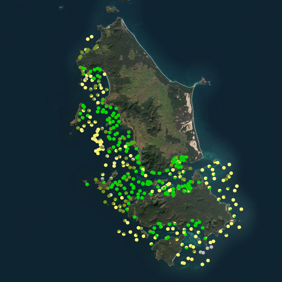
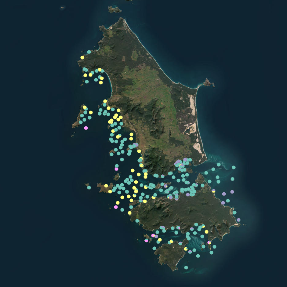
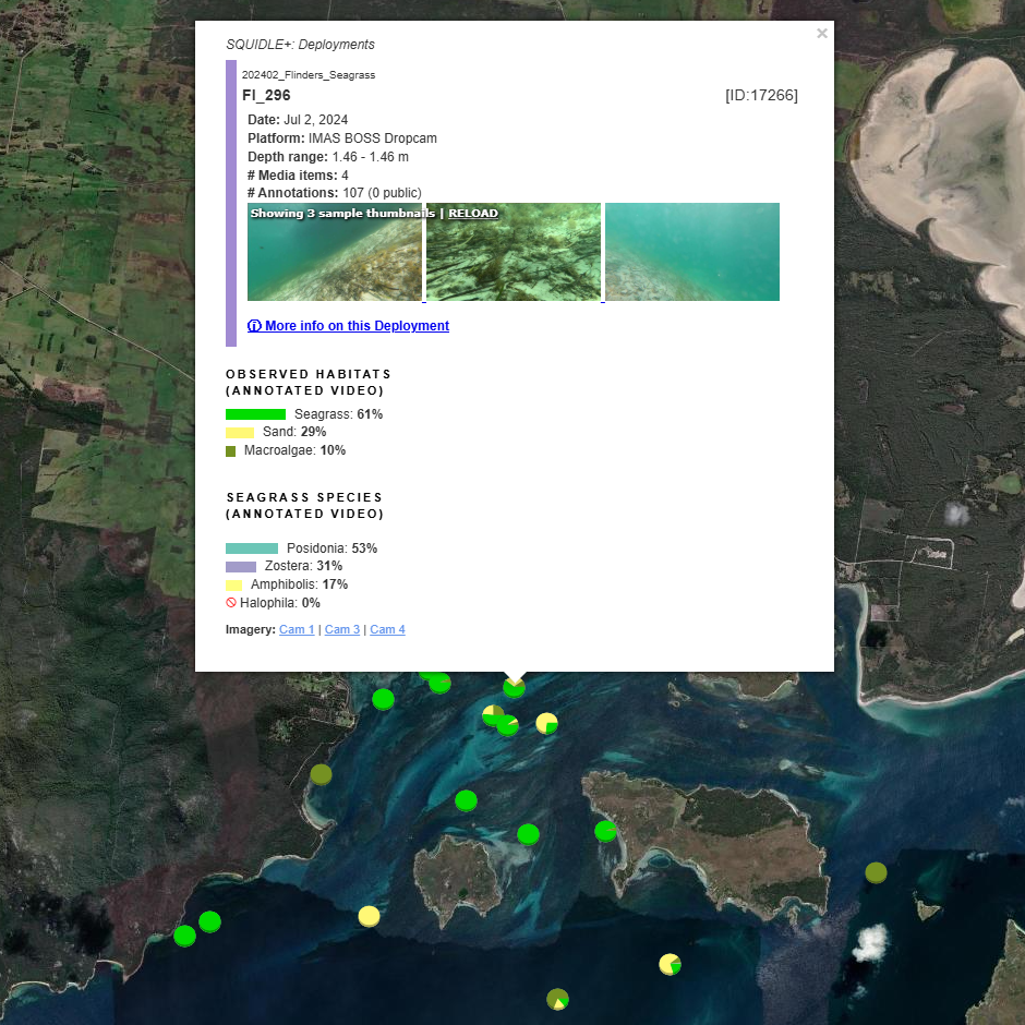
The field validation component of this study involved deployment of benthic video platforms to capture imagery of seagrass beds and associated ecosystems. A field campaign deployed a Benthic Observation Survey System (BOSS) and unBaited Remote Underwater stereo-Video system (stereo-uBRUV) at approximately 400 locations to collect photoquadrats and validate remote sensing outputs. Imagery annotation was conducted in the SQUIDLE+ platform.
The approach developed through this study contributed to the creation of the NESP Standard Operating Procedure (SOP) for Seagrass Mapping using Optical Remote Sensing ( https://sustainabledevelopmentreform.github.io/nesp-sop-seagrass-mapping)..
See the "Lineage" section of this record for full methodology of field collection techniques.
See associated dataset https://doi.org/10.25959/e4s6-ge74 for habitat maps derived from field validation and remote sensing inputs.
Simple
Identification info
- Date (Creation)
- 2025-04-26
Identifier
- Title
- Information and documentation - Digital object identifier system
- Citation identifier
- ISO 26324:2012
- Code
- 10.25959/WRXK-KV06
- Codespace
- doi.org
- Description
- Digital Object Identifier (DOI)
Principal investigator
Collaborator
Collaborator
Collaborator
Collaborator
Collaborator
Collaborator
Collaborator
Collaborator
- Credit
- The data collections described in this record are funded by the Australian Government Department of Climate Change, Energy, the Environment and Water (DCCEEW) through the NESP Marine and Coastal Hub. In addition to NESP (DCCEEW) funding, this project is matched by an equivalent amount of in-kind support and co-investment from project partners and collaborators.
- Status
- Completed
Point of contact
Point of contact
- Topic category
-
- Biota
Extent

Temporal extent
- Time period
- 2020-01-01 2023-12-31
Vertical element
- Minimum value
- 0
- Maximum value
- 30
- Identifier
- EPSG::5715
- Name
- MSL depth
- Maintenance and update frequency
- Not planned
- Keywords (Project)
-
- National Environmental Science Program (NESP) Marine and Coastal Hub
- GCMD Earth science Keywords
Resource constraints
- Classification
- Unclassified
Resource constraints
- Other constraints
- This dataset is hosted by the Institute for Marine and Antarctic Studies (IMAS), University of Tasmania, on behalf NESP Marine and Coastal Hub Project 3.6.
Resource constraints
- Linkage
-
http://i.creativecommons.org/l/by/4.0/88x31.png
License Graphic
- Title
- Creative Commons Attribution 4.0 International License
- Website
-
http://creativecommons.org/licenses/by/4.0/
License Text
- Other constraints
- Cite data as: Lucieer, V., Ierodiaconou, D., Lyons, M., Monk, J., Strain, E., Flukes, E., Hulls, J., Carnell, P., Dalby, O., Ellis, M. R., Sherman, C., Fractal, K., Yusuf, A., Trevathan-Tackett, S., Wise, A., Maher, F., & Cozens, Z. (2025). Imagery from BOSS and uBRUVs deployed for mapping temperate subtidal seagrass of Tayaritja Sea Country (Furneaux Group of Islands), Lutruwita (Tasmania) [Data set]. Institute for Marine and Antarctic Studies. https://doi.org/10.25959/WRXK-KV06
- Other constraints
- This dataset is hosted by the Institute for Marine and Antarctic Studies (IMAS), University of Tasmania, on behalf of NESP Marine and Coastal Hub Project 3.6.
Associated resource
- Title
- Related dataset: Mapping of temperate subtidal seagrass beds in Tayaritja Sea Country (Furneaux Group of Islands), Lutruwita (Tasmania)
Identifier
- Code
- 10.25959/e4s6-ge74
- Codespace
- doi.org
- Association Type
- Cross reference
Associated resource
- Title
- NESP MaC Project 3.6 - Exploring the distribution and ecological value of seagrass at the Furneaux Islands, Tasmania, 2023-2025 (IMAS, Deakin Uni)
Identifier
- Association Type
- Dependency
- Initiative Type
- Project
- Language
- English
- Character encoding
- UTF8
Distribution Information
- Distribution format
-
- Imagery (.jpg), CSV
- OnLine resource
- DATA ACCESS - raw and processed BOSS annotated observation data
- OnLine resource
-
R script for format standardisation of annotations
Processing workflow that converts raw BOSS annotated observation data into a training and validation dataset suitable for classification/mapping.
- OnLine resource
-
MaC_3_6_Furneaux_video_obs_pts
MAP - habitat composition (deployment points) styled by Seamap Aus classification
- OnLine resource
-
MaC_3_6_Furneaux_video_obs_sgspec_pts
MAP - habitat composition (deployment points) styled by dominant seagrass species
- OnLine resource
- View underwater imagery (BOSS, uBRUV) on SQUIDLE+
- OnLine resource
- View deployment locations (BOSS, BRUV) in map on SQUIDLE+
- OnLine resource
- View & explore mapping products in Seamap Australia
Resource lineage
- Statement
- Field data collection followed the protocols outlined in Section 5 of the Seagrass Mapping SOP (https://sustainabledevelopmentreform.github.io/nesp-sop-seagrass-mapping/#5-training-data-collection-and-curation), utilising a statistically balanced sampling approach that maintained uniform sampling intensity while avoiding preference or exclusion of any areas. Two stereo-video platforms were used to ground-truth habitat data in this study: the unBaited Remote Underwater stereo-Video system (stereo-uBRUV) and the Benthic Observation Sampling System (BOSS). Stereo-uBRUVs are a widely accepted method for surveying benthic fish communities, consisting of a pair of horizontally-facing cameras mounted inside a trapezoidal frame, which is deployed to the seafloor, typically for a period of ~1 hour. The BOSS system (https://drop-camera-field-manual.github.io) is a newer platform designed for rapid assessment of benthic communities, capturing detailed benthic habitat information in a single 3-5 minute deployment. It uses four horizontally-facing cameras mounted at 90 degree angles and captures a ~270° downwards-facing view, generating high-resolution panoramic imagery of the seafloor. The CATAMI classification scheme was used for benthic feature labeling, with points annotated using the SQUIDLE+ platform (https://squidle.org). For both methods, additional metadata such as deployment location, water depth, date, and time were recorded. All deployments followed standard operating procedures outlined in the national marine sampling field manuals (https://marine-sampling-field-manual.github.io). All imagery is publicly accessible at SQUIDLE+: https://squidle.org/geodata/explore/img?filters={"campaign_ids":[967,1106,1138]} See 3.6 Case Study SOP (https://sustainabledevelopmentreform.github.io/nesp-sop-seagrass-mapping/case_study_NESP3.6/NESP_3.6_case_study.html) for code associated with
- Hierarchy level
- Dataset
Metadata
- Metadata identifier
- urn:uuid/8f3696d0-ae35-4d48-8a79-59121a5ae168
- Language
- English
- Character encoding
- UTF8
Point of contact
Type of resource
- Resource scope
- Dataset
- Metadata linkage
-
https://metadata.imas.utas.edu.au/geonetwork/srv/eng/catalog.search#/metadata/8f3696d0-ae35-4d48-8a79-59121a5ae168
Point of truth URL of this metadata record
- Date info (Creation)
- 2015-05-06T11:44:25
- Date info (Revision)
- 2026-07-27T10:23:05
Metadata standard
- Title
- ISO 19115-3:2018
Overviews
Spatial extent

Provided by
