 IMAS Metadata Catalogue
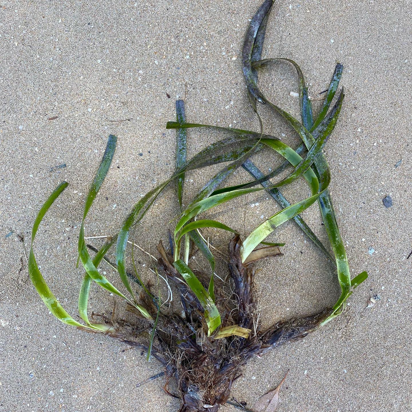
seagrass
Type of resources
Topics
Keywords
Contact for the resource
Provided by
Years
-
This record provides an overview of the scope and research data outputs of the NESP Marine Biodiversity Hub project "Assisting the restoration of seagrasses at Shark Bay". For specific data outputs from this project, please see child records associated with this metadata. -------------------- This project is a collaboration between scientists and the Shark Bay Malgana Indigenous community into jointly developed seeding and shoot planting methods to assist natural recovery of seagrasses in preparation for future devastating impacts of climate change. The Shark Bay World Heritage Site (WHS) is unique globally for its natural values, including stromatolites, seagrass meadows and marine megafauna including dugongs, sharks, turtles, and dolphins. The immediate goal is to scale up the existing restoration research to assist recovery of the dominant seagrasses, Amphibolis antarctica and Posidonia australis following the 2011 marine heat wave. Planned Outputs • A seagrass restoration toolkit (multimedia and report format) - will include information on sourcing suitable genetic material • Data on the trial seed restoration outcomes
-
Genomic sampling locations and meadow indices for ribbon weed (Posidonia australis) and wire weed (Amphibolis antarctica) in Shark Bay (Gathaagudu)
-
Growth (shoot count) of Amphibolis antarctica and Posidonia australis following transplant to Middle Bluff and Dubaut Point, Shark Bay. Plants were transplanted by the Malgana people with assistance from UWA staff then assessed for shoot counts after 8 months.
-
Sediment organic carbon assessments within plots of transplanted Posidonia australis seagrass, and compared to adjacent bare sand and healthy meadows, in Shark Bay, WA.
-
Biodiversity assessments of invertebrates within seagrass (Amphibolis antarctica and Posidonia australis) transplant plots, compared to adjacent bare sand and healthy meadows at Middle Bluff, Dubaut Point and Useless Loop, Shark Bay.
-
Assessment of Posidonia australis transplant survival at 3, 8, 12, 18, and 26 months (August transplant); and 3, 8, 12, 18, 26 and 30 months (April transplant), after planting at Middle Bluff, and Dubaut Point, Shark Bay.
-
Efforts to restore Posidonia seagrass meadows in NSW are reliant on collecting beachcast fragments as collection of donor material from extant beds is prohibited. However, to maximise the collection efforts it necessary to understand where to collect fragments from and what environmental conditions (e.g. wind direction, wind strength, tidal height) increase the availability of fragments and where to collect the most healthy fragments. This data set captures the abundance of fragments at 7 sites in Gamay (Botany Bay), an area of interest for restoration of Posidonia australis. It investigates how characteristics of wind (speed and direction), tidal height and swell (height, direction) influence the availability (abundance) and health (as determined by observations of necrosis) of shoots at sites throughout Botany Bay. The Excel data workbook is comprised of two sheets: Fragments_data sheet shows the number of P. australis fragments collected at different sites, when they were collected, and the environmental conditions at collection (see data attributes section). Shoot_data sheet shows the proportion of necrosis of shoots attached to collected fragments.
-
The distribution of seagrass and associated benthic communities was mapped between the 29 July and 29 August 1997 on the reef and lagoon at Low Isles, Great Barrier Reef. For this survey, a total of 349 benthic survey points were examined by observers walking or free‐diving at survey points positioned approximately 50 m apart along a series of transects. To assist with mapping meadow boundaries, an additional 177 points were assessed and a 1:12,000 rectified aerial photo was commissioned (26th August 1997). A differential handheld global positioning system (GPS) was used to locate each point assessed. 127.8 ±29.6 hectares of seagrass was mapped.
-
Total organic carbon (TOC) sediment stocks as a CO2 mitigation service require exclusion of allochthonous black (BC) and particulate inorganic carbon corrected for water–atmospheric equilibrium (PICeq). For the first time, we address this bias for a temperate salt marsh and a coastal tropical seagrass in BC hotspots that represent two different blue carbon ecosystems of Malaysia and Australia. Seagrass TOC stocks were similar to the salt marshes with soil depths < 1 m (59.3 ± 11.3 and 74.9 ± 18.9 MgC ha-1, CI 95% respectively). Both ecosystems showed larger BC constraints than their pristine counterparts did. However, the seagrass meadows’ mitigation services were largely constrained by both higher BC/TOC and PICeq/TOC fractions (38.0% ± 6.6% and 43.4% ± 5.9%, CI 95%) and salt marshes around a third (22% ± 10.2% and 6.0% ± 3.1% CI 95%). The results provide useful data from underrepresented regions, and, reiterates the need to consider both BC and PIC for more reliable blue carbon mitigation assessments.
-
Distribution and abundance of seagrass, mangrove and saltmarsh in NSW estuaries. This dataset is ongoing. This record describes a snapshot of the data taken in February 2023 for use in the Seamap Australia project. A more recent version of the dataset may be available through the NSW DPI Fisheries Data Portal. This dataset supersedes https://metadata.imas.utas.edu.au/geonetwork/srv/eng/catalog.search#/metadata/281FAA64-F6F3-400C-A48F-D342E4ABCA83 (Estuarine macrophytes of NSW 2009) and https://metadata.imas.utas.edu.au/geonetwork/srv/eng/catalog.search#/metadata/021f65eb-38c6-4db2-9dbe-821b6b427780 (An Estuarine Inventory for NSW 1984).