 IMAS Metadata Catalogue
reef
Type of resources
Topics
Keywords
Contact for the resource
Provided by
Years
-

Surveying habitats critical to the survival of grey nurse sharks in South-East Queensland has mapped critical habitats, gathered species inventories and developed protocols for ecological monitoring of critical habitats in southern Queensland. This information has assisted stakeholders with habitat definition and effective management. In 2002 members of UniDive applied successfully for World Wide Fund for Nature, Threatened Species Network funds to map the critical Grey Nurse Shark Habitats in south east Queensland. UniDive members used the funding to survey, from the boats of local dive operators, Wolf Rock at Double Island Point, Gotham, Cherub's Cave, Henderson's Rock and China Wall at North Moreton and Flat Rock at Point Look Out during 2002 and 2003. These sites are situated along the south east Queensland coast and are known to be key Grey Nurse Shark aggregation sites. During the project UniDive members were trained in mapping and survey techniques that include identification of fish, invertebrates and substrate types. Training was conducted by experts from the University of Queensland (Centre of Marine Studies, Biophysical Remote Sensing) and the Queensland Parks and Wildlife Service who are also UniDive members. The monitoring methods (see methods) are based upon results of the UniDive Coastcare project from 2002, the international established Reef Check program and research conducted by Biophysical Remote Sensing and the Centre of Marine Studies. This record describes the digitised habitat features for Wolf Rock. View the original metadata record at https://doi.pangaea.de/10.1594/PANGAEA.864211 for the full data collection.
-

Seagrass meadow extent and meadow-scape was mapped using four alternative approaches at Yule Point, a coastal clear water habitat, in the Cairns section of the Great Barrier Reef, between October 2017 and July 2020. Approach 1 included mapping meadow boundaries and meadow-scape during low spring tides on foot using a handheld GPS. Approach 2 was where the meadows were surveyed at low tide with observations from a helicopter, with observational spot-checks conducted at a number haphazardly scattered points. Approach 3 used imagery collected during low spring tides with a UAV at an altitude of 30 m with a resolution of 0.2cm/pixel. Approach 4 used PlanetScope Dove imagery captured on 05 September 2017 and 09 August 2019 coinciding as close as possible to the field-surveys in 2017 and 2019, with 3.7 m x 3.7 m pixels (nadir viewing) acquired from the PlanetScope archive. This record describes meadow extent data collected using Approach 4 (PlanetScope imagery). View the original metadata record at https://doi.pangaea.de/10.1594/PANGAEA.946604 for the full data collection.
-
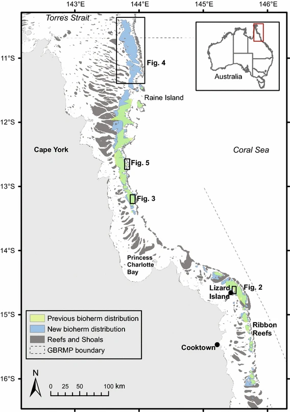
Sediment derived from the decomposition of Halimeda algae is a major contributor to the tropical back-reef carbonate depositions. Halimeda bioherms occur extensively on the northern Great Barrier Reef (GBR), Australia. This dataset represents the most complete, high-resolution spatial mapping of the extent of northern GBR Halimeda bioherms, based on airborne lidar and multibeam echosounder bathymetry data. Three distinct morphological sub-types are described: reticulate, annulate, and undulate. The northern GBR bioherms cover an area of 6095 km2, three times larger than previous estimates.
-
The distribution of seagrass and associated benthic communities was mapped between the 29 July and 29 August 1997 on the reef and lagoon at Low Isles, Great Barrier Reef. For this survey, a total of 349 benthic survey points were examined by observers walking or free‐diving at survey points positioned approximately 50 m apart along a series of transects. To assist with mapping meadow boundaries, an additional 177 points were assessed and a 1:12,000 rectified aerial photo was commissioned (26th August 1997). A differential handheld global positioning system (GPS) was used to locate each point assessed. 127.8 ±29.6 hectares of seagrass was mapped.
-
Approximately 2,362 ±289 km2 of seagrass meadows were mapped in the waters of Hervey Bay and Great Sandy Strait between 6 and 14 December 1998. This was the first comprehensive survey of the Great Sandy region. The survey involved examination of 1,104 field validation points and identified 174 individual meadows. Seagrass extended from the intertidal and shallow subtidal waters to a depth of 32m. Seven species of seagrass were identified (Cymodocea serrulata, Halodule uninervis, Syringodium isoetifolium, Halophila decipiens, Halophila ovalis, Halophila spinulosa and Zostera muelleri) within 22 seagrass meadow/community types. Mapping survey methodologies followed standardised global seagrass research methods for intertidal, shallow subtidal (2‐10m depth) and deep waters (>10m) using both in situ and remote assessments. View the original metadata record at https://doi.org/10.1594/PANGAEA.876714.
-

Seagrass meadow extent and meadow-scape was mapped using three alternative approaches at Midge Point, a coastal turbid water habitat, in the central section of the Great Barrier Reef, in September/October 2017. Approach 1 included mapping meadow boundaries and meadow-scape during low spring tides on foot using a handheld Garmin GPS. Approach 2 was where the meadows were surveyed at low tide with observations from a helicopter, with observational spot-checks conducted at a number haphazardly scattered points. Approach 3 used PlanetScope Dove imagery captured on 09 October 2017 coinciding as close as possible to the field-surveys, with 3.7 m x 3.7 m pixels (nadir viewing) acquired from the PlanetScope archive. This record describes meadow extent data collected using Approach 3 (PlanetScope imagery). View the original metadata record at https://doi.org/10.1594/PANGAEA.946606 for the full data collection.
-

Seagrass meadow extent and meadow-scape was mapped using two alternative approaches at Green Island, a reef clear water habitat, in the Cairns section of the Great Barrier Reef, in November 2020. Approach 1 included mapping seagrass meadow-scape using imagery captured during low spring tides with a DJI Mavic 2 Pro UAV at an altitude of 100 m, with a resolution of 2.45cm/pixel. Approach 2 used PlanetScope Dove imagery captured on 05 November 2020 coinciding as close as possible to the field-surveys from 25 to 27 November 2020, with 3.7 m x 3.7 m pixels (nadir viewing) acquired from the PlanetScope archive. This record describes meadow extent data collected using Approach 2 (PlanetScope imagery). View the original metadata record at https://doi.pangaea.de/10.1594/PANGAEA.946605 for the full data collection.