 IMAS Metadata Catalogue
Spatial distribution and morphology of the Halimeda bioherms of the Great Barrier Reef, Australia
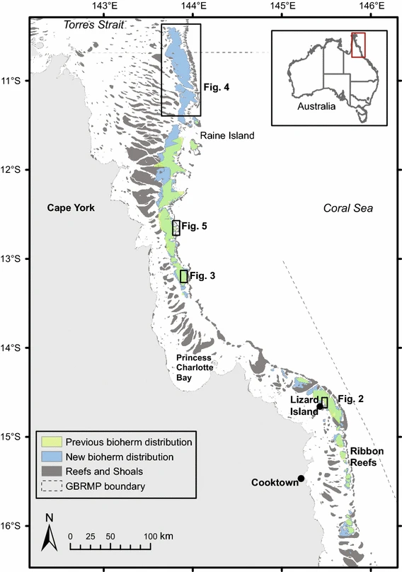
Sediment derived from the decomposition of Halimeda algae is a major contributor to the tropical back-reef carbonate depositions. Halimeda bioherms occur extensively on the northern Great Barrier Reef (GBR), Australia. This dataset represents the most complete, high-resolution spatial mapping of the extent of northern GBR Halimeda bioherms, based on airborne lidar and multibeam echosounder bathymetry data. Three distinct morphological sub-types are described: reticulate, annulate, and undulate. The northern GBR bioherms cover an area of 6095 km2, three times larger than previous estimates.
Simple
Identification info
- Date (Publication)
- 2023-04-24
Principal investigator
coInvestigator
coInvestigator
coInvestigator
- Status
- Completed
Point of contact
- Spatial representation type
- Vector
- Topic category
-
- Biota
Extent
))
Temporal extent
- Time period
- 2016-08-24 2016-08-24
Resource format
- Title
- ESRI Shapefile
- Date
- Edition
- -
- Global Change Master Directory (GCMD) Earth Science Keywords Version 8.0
- Keywords (Place)
-
- northern Great Barrier Reef
- Keywords (Theme)
-
- Halimeda bioherm
- Great Barrier Reef
- reef
Resource specific usage
- Specific usage
- Data supplied for use by the Seamap Australia Project.
Resource constraints
- Classification
- Unclassified
Resource constraints
- Linkage
-
http://i.creativecommons.org/l/by/4.0/88x31.png
License Graphic
- Title
- Creative Commons Attribution 4.0 International License
- Website
-
http://creativecommons.org/licenses/by/4.0/
License Text
- Other constraints
- Cite data as: McNeil, M., Webster, J., Beaman, R., Graham, T. (2016). spatial distribution and morphology of the Halimeda bioherms of the Great Barrier Reef, Australia. Data accessed at https://metadata.imas.utas.edu.au/geonetwork/srv/eng/catalog.search#/metadata/b8475bea-e24e-4374-8090-ef06514b951d on (access date).
- Other constraints
- This dataset has been downloaded from https://doi.org/10.1007/s00338-016-1492-2 and is hosted by the Institute for Marine and Antarctic Studies (IMAS), University of Tasmania, on behalf of James Cook University (JCU) for the purposes of the Seamap Australia collaborative project.
- Language
- English
- Character encoding
- UTF8
- Supplemental Information
- McNeil, M.A., Webster, J.M., Beaman, R.J. et al. New constraints on the spatial distribution and morphology of the Halimeda bioherms of the Great Barrier Reef, Australia. Coral Reefs 35, 1343–1355 (2016). https://doi.org/10.1007/s00338-016-1492-2
Content Information
- Content type
- Physical measurement
- Description
- Appended to original data for styling purposes for the Seamap Australia Project
- Name
- Benthic habitat
- Name
- SM_HAB_CLS
Identifier
- Code
- Abundance of biota
Distribution Information
- Distribution format
-
- ESRI Shapefile
- OnLine resource
-
SHAPE-ZIP
DATA ACCESS - This OGC WFS service returns the data (northern GBR Halimeda bioherms) in Shapefile format.
- OnLine resource
-
seamap:SeamapAus_QLD_Halimeda_bioherms_2016
MAP - Halimeda bioherms of the northern GBR
Resource lineage
- Statement
- To accurately map the total areal extent and redefine the geomorphology of the GBR bioherms, this study synthesised a range of information derived from new airborne lidar and multibeam bathymetry datasets, seismic profiling data, and combining these with existing sediment sampling surveys, seismic profiles, and vibracores taken from the published literature. Comparisons were made between the previously reported Halimeda bioherm spatial extent, distribution, and morphology descriptions, and our analysis of the new and existing data. See https://doi.org/10.1007/s00338-016-1492-2 for full methodology.
- Hierarchy level
- Dataset
- Hierarchy level
- Dataset
Platform
Identifier
- Code
- diver
Platform
Identifier
- Code
- research aeroplane
Platform
Identifier
- Code
- research vessel
Metadata
- Metadata identifier
- b8475bea-e24e-4374-8090-ef06514b951d
- Language
- English
- Character encoding
- UTF8
Point of contact
- Parent metadata
Type of resource
- Resource scope
- Dataset
- Metadata linkage
-
https://metadata.imas.utas.edu.au/geonetwork/srv/eng/catalog.search#/metadata/b8475bea-e24e-4374-8090-ef06514b951d
Point of truth URL of this metadata record
- Date info (Creation)
- 2020-09-23T12:36:21
- Date info (Revision)
- 2020-09-23T12:36:21
Metadata standard
- Title
- ISO 19115-3:2018
Overviews
Spatial extent
Provided by
