 IMAS Metadata Catalogue
2012
Type of resources
Topics
Keywords
Contact for the resource
Provided by
Years
-

An aerial survey was conducted for giant kelp (Macrocystis pyrifera) on the east coast of Tasmania from Eddystone Point to Southeast Cape. This survey represents part of a series of similar surveys, with historic aerial surveys having been conducted in 1986 and 1999. The survey was conducted via light aircraft. Areas of visable Macrocystis pyrifera beds were marked on topographical land tenure maps using landmarks as references, and complimentary photo footage was collected.
-
A supervised classification was applied to a Landsat TM5 image. This image was acquired 9:40 am, on the 27th July 2011 (5.14 am low tide at Brisbane Bar). The image classification was applied on areas of clear waters up to three metres depth and for exposed regions of Moreton Bay. Field validation data was collected at 4797 survey sites by UQ. GPS referenced field data were used as training areas for the image classification process. For this training the substrate DN signatures were extracted from the Landsat 5 TM image for field survey locations of known substrate cover, enabling a characteristic "spectral reflectance signature" to be defined for each target. The Landsat TM image, containing only those pixels in water < 3.0m deep, was then subject to minimum distance to means algorithm to group pixels with similar DN signatures (assumed to correspond to the different substrata). This process enabled each pixel to be assigned a label of either seagrass cover (0, 1-25 %, 25-50 %, 50-75 % and 75-100 %). The resulting raster data was then converted into a vector polygon file. Species information was added based on the field data and expert knowledge. Both polygon files were joined by overlaying features of remote sensing files with the EHMP field data to produce an output theme that contains the attributes and full extent of both themes. If polygons of remote sensing were within polygons of field data the assumption was made that the remote sensing polygon was showing more detail and the underlying field polygon was deleted.
-
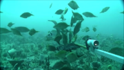
The Flinders CMR survey was a pilot study undertaken in August 2012 as part of the National Marine Biodiversity Hub's National monitoring, evaluation and reporting theme. The aim of this theme is to develop a bluepint for the sustained monitoring of the South-east Commonwealth Marine Reserve Network. The particular aims of the survey were twofold; 1) to contribute to an inventory of demersal and epibenthic conservation values in the reserve and 2) to test methodologies and deployment strategies in order to inform future survey design efforts. Several gear types were deployed; including multibeam sonar, shallow-water (less than 150m) Baited Remote Underwater Video (BRUVs), deep- water BRUVs, towed video and digital stereo stills. This resource contains the shallow-water BRUV footage captured on the FLinders CMR shelf (less than 150 m). Stereo BRUV's were deployed using a probabalistic and spatially-balanced survey design called Generalized Random Tessellation Stratified (GRTS). Habitats were identified in a previous multibeam survey and consisted of 'mixed reef' (containing patchy reef) and sand. Mixed reef habitat was targeted in this survey (9 GRTS mixed reef sites versus 3 sand sites). A total of 60 stereo BRUVs were deployed. Data contained here represents footage collected using these drops and the associated scored data (abundance (MaxN) and lengths).
-
Geoscience Australia has completed the first phase of an areal map of Australia's coastal geomorphological units. Utilising pre-existing GIS datasets procured from local, state and federal government agencies, this national scale map conforms to a coastal geomorphology classification scheme developed at Geoscience Australia. Phase one consists of a geodatabase containing a series of state wide feature datasets that have been reclassified into the national coastal geomorphology classification scheme.