 IMAS Metadata Catalogue
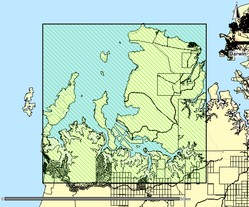
Mangrove Mapping Bynoe Harbour, 1998
This polygon spatial dataset describes the mangrove communities for Bynoe Harbour and its environs. The original field survey was undertaken in 1998 at a mapping scale of 1:25,000. The associated report notes an area of approximately 24,000 hectares of mangroves in Bynoe Harbour and describes ten main mangrove associations or communities. The data provides a basis for identifying the extent and distribution of mangrove communities for Bynoe Harbour and its environs.
Mangrove mapping was updated over this area in a 2016 survey. See metadata record for Mangrove Community Mapping - Charles Point to Gunn Point. www.ntlis.nt.gov.au/metadata/export_data?type=html&metadata_id=87F656131848A609E050CD9B214417E1
Simple
Identification info
- Date (Creation)
- 2000-01-14
- Date (Publication)
- 2017-04-27
- Date (Revision)
- 2022-09-01
- Credit
- Data supplied by Department of Environment and Natural Resources. © Copyright Northern Territory of Australia
- Status
- Completed
Point of contact
- Spatial representation type
- Vector
Spatial resolution
Equivalent scale
- Denominator
- 25000
- Topic category
-
- Biota
- Oceans
Extent
))
Temporal extent
- Time period
- 1996-01-12 2003-03-01
- Maintenance and update frequency
- Not planned
Resource format
- Title
- ESRI Shapefile
- Date
- Edition
- -
- Global Change Master Directory (GCMD) Earth Science Keywords Version 8.0
- Keywords (Theme)
-
- Benthic habitat
Resource specific usage
- Specific usage
- Data supplied for use by the Seamap Australia Project.
Resource constraints
- Classification
- Unclassified
Resource constraints
- Linkage
-
http://i.creativecommons.org/l/by-sa/4.0/88x31.png
License Graphic
- Title
- Creative Commons Attribution-ShareAlike 4.0 International License
- Website
-
http://creativecommons.org/licenses/by-sa/4.0/
License Text
- Other constraints
- Cite data as: Department of Environment and Natural Resources, Northern Territory Government of Australia (2000). Mangrove mapping of Bynoe Harbour. Data accessed at http://metadata.imas.utas.edu.au/geonetwork/srv/en/metadata.show?uuid=a528d225-9668-43d2-a8b8-ce5b7e3ec02e on (access date).
- Other constraints
- This dataset is hosted by the Institute for Marine and Antarctic Studies (IMAS), University of Tasmania, on behalf of the NT Government for the purposes of the Seamap Australia collaborative project (testing a national marine benthic habitat classification scheme).
- Language
- English
- Character encoding
- UTF8
- Supplemental Information
- Department Survey Code (Vegetation Survey): MANGB_25 This spatial dataset should not be used at scales greater than 1: 25,000 Bibliographic Reference: Brocklehurst, P. & Edmeades, B. (2003). MANGROVE SURVEY OF BYNOE HARBOUR, NORTHERN TERRITORY. Technical Report No 01/2003D, Department of Infrastructure, Planning and Environment, Palmerston, NT. Report - Download (PDF) from the Northern Territory Library via hdl.handle.net/10070/244762
Content Information
- Content type
- Physical measurement
- Description
- Taxonomic identification of mangrove species and vegetation types
Identifier
- Name
- VEG_TYPE
- Description
- Appended to original data for styling purposes for the Seamap Australia Project.
- Name
- Benthic habitat
- Name
- SM_HAB_CLS
Distribution Information
- Distribution format
-
- ESRI Shapefile
OnLine resource
- Protocol
- OGC:WFS-1.0.0-http-get-feature--shapefile
- Name of the resource
- SHAPE-ZIP
- Description
- DATA ACCESS - This OGC WFS service returns the data (Bynoe Harbour mangroves) in Shapefile format.
- OnLine resource
-
seamap:SeamapAus_NT_BynoeHarbour_mangrove
MAP - Mangrove mapping Bynoe Harbour
- OnLine resource
- Original metadata record [NT Government catalogue]
Data quality info
- Hierarchy level
- Dataset
Report
- Name of measure
- Positional Accuracy
- Measure description
- Derived from topographic basemap, NT cadastre and GPS. The summation of errors from all sources results in data with a standard deviation defined by scale used as +/-50m for well-defined points.
Report
- Name of measure
- Attribute Accuracy
- Measure description
- The accuracy of the attribute information is considered high and conforms to the 'Australian Soil and Land Survey Field Handbook' at time of capture.
Report
- Name of measure
- Logical consistency
- Measure description
- Dataset topological consistency has been system checked and all classified polygons are closed, nodes are formed at the intersection of lines and there is only one label within each polygon. Polygons have been classified for community ID in the lookup table.
Report
- Name of measure
- Completeness
- Measure description
- Complete
Resource lineage
- Statement
- Original linework derived visually and captured direct into GIS system from scaned aerial photography as vector information, resultant compilation then built as polygon coverage using ArcInfo giving preliminary map used to delinate community boundaries and site selection. Resultant linework extensively ground truthed with topographic basemap/GPS coordinated field survey/site data collection. Recompiled and updated to GDA94 as part of ongoing GIS Progarm 2004. Source data Aerial photography - 1:18,000 Col 1995/97 - Bynoe Harbour Base map - Australian Topographic Survey Series 1:50,000 AGD66 - Northern Territory Cadastre AGD66 GIS - ArcInfo vector as AGD66/GDA94
- Hierarchy level
- Dataset
- Hierarchy level
- Dataset
Platform
Identifier
- Code
- research aeroplane
Metadata
- Metadata identifier
- urn:uuid/a528d225-9668-43d2-a8b8-ce5b7e3ec02e
- Language
- English
- Character encoding
- UTF8
Point of contact
- Parent metadata
Type of resource
- Resource scope
- Dataset
- Metadata linkage
-
https://metadata.imas.utas.edu.au/geonetwork/srv/eng/catalog.search#/metadata/a528d225-9668-43d2-a8b8-ce5b7e3ec02e
Point of truth URL of this metadata record
- Date info (Creation)
- 2020-10-12T15:53:30
- Date info (Revision)
- 2025-09-14T14:03:13
Metadata standard
- Title
- ISO 19115-3:2018
Overviews
Spatial extent
Provided by
