 IMAS Metadata Catalogue
research aeroplane
Type of resources
Topics
Keywords
Contact for the resource
Provided by
Years
-
This is a collection of polygons outlining signficant seagrass meadows around Arnhem Land, Kakadu and Gulf of Carpentaria coastal waters for the Northern Australia Marine Biodiversity Survey (NAMBS) project between 2003 and 2005. Data was collected from imagery and ground truthed by observers from helicopter and insitu sample grabs.
-
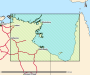
This polygon spatial dataset describes the mangrove communities for Bynoe Harbour and its environs. The original field survey was undertaken in 1998 at a mapping scale of 1:25,000. The associated report notes an area of approximately 24,000 hectares of mangroves in Bynoe Harbour and describes ten main mangrove associations or communities. The data provides a basis for identifying the extent and distribution of mangrove communities for Bynoe Harbour and its environs. Mangrove mapping was updated over this area in a 2016 survey. See metadata record for Mangrove Community Mapping - Charles Point to Gunn Point. www.ntlis.nt.gov.au/metadata/export_data?type=html&metadata_id=87F656131848A609E050CD9B214417E1
-
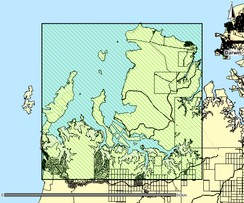
This polygon spatial dataset describes the benthic habitats likely to occur in marine environments around Gunn Point Peninsula and informs the desktop assessment of the marine biodiversity values for the region. The benthic habitats are inferred from existing information but in most cases require further data collection to validate and refine. Habitat modelling forms the basis of benthic community value assessment for Shoal Bay (Galaiduk et al. 2019). The accompanying report Marine and Coastal Biodiversity Assessment of the Gunn Point Area (2020) forms part of the Mapping the Future Project - Gunn Point. This project has identified land capability, water availability and biodiversity values to support land planning and inform development potential over the Gunn Point area. Reports and maps can be viewed from the webpage: denr.nt.gov.au/land-resource-management/development-opportunities - Development Potential of the Gunn Point Area (2020) - Biodiversity Assessment of the Gunn Point Area (2020) - Groundwater Resources of the Gunn Point Area (2020) - Marine and Coastal Biodiversity Assessment of the Gunn Point Area (2020) - Soil and Land Resources of the Gunn Point Area (2020) - Soil and Land Suitability Assessment for Irrigated Agriculture in the Gunn Point Area (2017) - Vegetation Communities of the Gunn Point Area (2020)
-
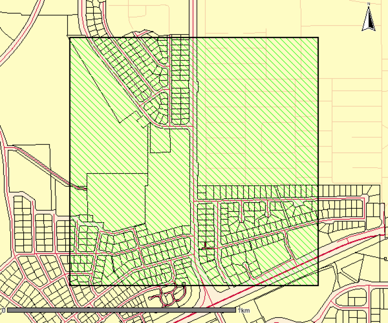
This is a high resolution survey (1:5,000 scale dataset) describing mapped vegetation communities for the Ludmilla Creek catchment area (within the City of Darwin, Northern Territory). (Vegetation Unit - A reasonably homogeneous part of the land surface, distinct from surrounding terrain with constant properties in landform and vegetation) This vegetation survey was undertaken in 1996. This dataset represents the vegetation on the ground at the time of the survey and reflects the data and methods used to create the mapped polygons. The dataset has been revised in 2015 to include community descriptions but has not been updated to reflect the vegetation on the ground. The Darwin Remnant Vegetation Survey is considered a more up-to-date representation of vegetation for this area.
-
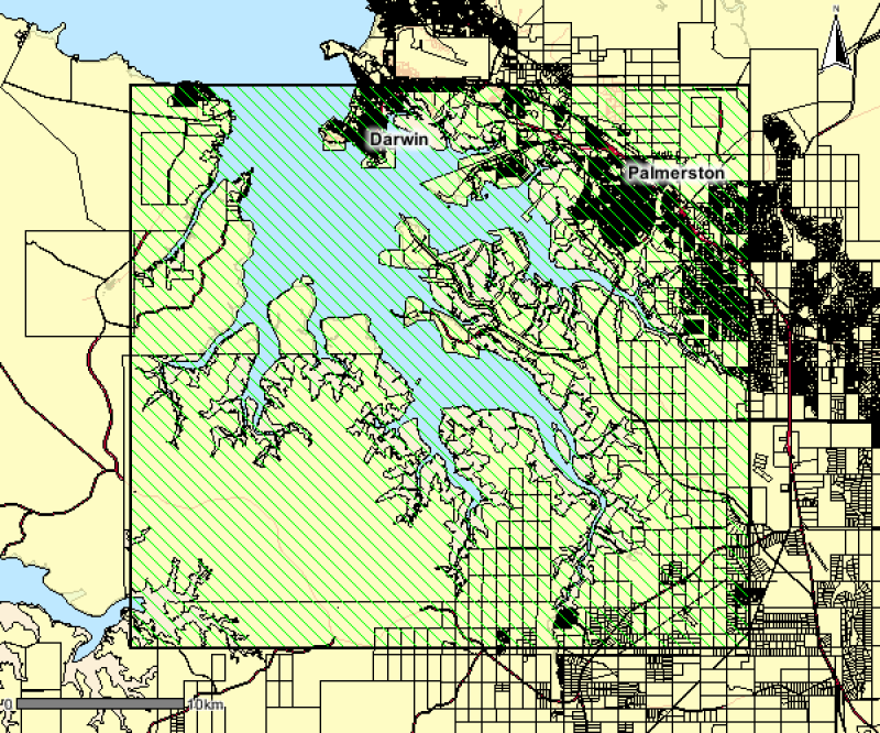
This polygon spatial dataset describes the mangrove communities for Darwin Harbour and its environs and was surveyed at a mapping scale of 1:25 000. The associated report notes an area of approximately 20,400 hectares of mangroves in Darwin Harbour and describes ten main mangrove associations or communities. The data provides a basis for identifying the extent and distribution of mangrove communities for Darwin Harbour and its environs.
-
This spatial polygon dataset is derived from the 2001 mapping of mud crab (Scylla serrata) habitats along the NT and Queensland coastal wetlands. The polygons were derived from Landsat imagery and verified with field work and is suitable for use at scale 1:100,000. The information can be used in many ways to assist the management of these habitats. It provides a suitable baseline dataset for monitoring broad scale changes in area and composition of coastal wetland communities. Additionally, it provides information required by managers for choosing representative habitats for protection.
-

In 2016-2017, UniDive (The University of Queensland Underwater Club) conducted an ecological assessment of the Flinders Reef Dive sites - the FREA project. Involvement in the project was voluntary. Members of UniDive who were marine experts conducted training for other club members who had no, or limited, experience in identifying marine organisms and mapping habitats. Habitats were mapped using a combination of towed GPS photo transects, WorldView-2 satellite imagery and expert knowledge. This data provides georeferenced information regarding the major features of each of the Flinders Reef Dive Sites.
-

The study involved the collection of field data and acquisitioning of satellite imagery to create a map that presents a benthic inventory of reefal habitat areas within Moreton Bay. Mapping was guided by the most recent reef map (Queensland Environmental Protection Agency, 2004), the new field data, local knowledge and/or visual interpretation of high spatial resolution satellite imagery. The inventories for each reefal area were based on georeferenced spot check field data collected by volunteer teams in 2015 and 2016 (n=610). This field data was overlayed on high spatial resolution ZY-3 satellite imagery (5 m x 5 m pixels) captured in June 2014. Polygons were manually digitised around reefal areas by an expert from the Remote Sensing Research Centre using visual interpretation of the texture and colour of the pixels in the satellite imagery, as related to water depth, field data and local field knowledge. Polygons were subsequently assigned one of three categories (Coral on reef matrix, Soft Coral on Sand/Rubble, and, Algae on sand/rubble). The project was a collaborative citizen science project between Reef Check Australia, The University of Queensland Remote Sensing Research Centre and Healthy Waterways to collect benthic inventories for eight key subtropical reefal areas in Central Moreton Bay - Mud, Saint Helena, Green, King, Macleay, Goat, and Peel Islands, and, Myora Reef.
-
An aerial survey was conducted for giant kelp (Macrocystis pyrifera) on the east coast of Tasmania from Eddystone Point to Southeast Cape. This survey represents part of a series of similar surveys, with historic aerial surveys having been conducted in 1986 and 1999. The survey was conducted via light aircraft. Areas of visable Macrocystis pyrifera beds were marked on topographical land tenure maps using landmarks as references, and complimentary photo footage was collected.
-
Seagrass meadows within the Broadwater were mapped using high-resolution 2005 orthorectified color aerial photography obtained from the Gold Coast City Council at a scale of 1:10,000 and pixel size 0.15 m. Using desktop GIS mapping (MapInfo Professional 8.0), polygons were drawn over all potential seagrass meadows at a scale of 1:5000. Spatial accuracy was estimated to be approximately ± 1 m on well-defined boundaries (e.g. dense seagrass meadows) and ± 2 m along poorly defined boundaries (e.g. sparse seagrass meadows).