 IMAS Metadata Catalogue
MARINE ECOSYSTEMS
Type of resources
Topics
Keywords
Contact for the resource
Provided by
Years
-
Jurien Bay Boat Harbour is located north of the town of Jurien Bay, ~250 km north of Perth, Western Australia. The Boat Harbour services a range of government, recreational and commercial vessels and is managed by the WA Department of Transport (DoT). Wrack and marine sediments frequently accumulate in the Boat Harbour, negatively affecting the navigability, environment and aesthetic quality of the Harbour. To manage these impacts, routine maintenance dredging is undertaken by DoT. To inform future dredging requirements and marine environmental management of the Boat Harbour, BMT undertook benthic habitat mapping of Jurien Bay in November 2017 on behalf of DoT. The objectives of the mapping project were to: i. collect baseline data on the spatial extent and characteristics of benthic habitats in the mapping area, and ii. qualitatively characterise the extent of benthic primary producer habitat surrounding the Boat Harbour, and develop a mapping product to inform dredging operations and potential future environmental approvals applications, if necessary. Mapping was conducted by first collating satellite imagery to identify benthic habitat features to be ground-truthed by towed video. Video footage was annotated with biological attributes and combined with the satellite imagery to create classified benthic habitat maps of an area offshore of the Boat Harbour. See the "Lineage" section of this record and attached survey report for detailed methodology.
-
This dataset comprises summaries of sight and resight data compiled for the NESP MBH project A13 and derived from data housed in the Australian Right Whale Photo Identification Catalogue (ARWPIC) and associated effort summaries. These summaries have been compiled as part of an analysis of mark recapture information in establishing trends in the population and spatial connectivity of individuals across southern Australia. The summaries are based on original sightings data collected across 1990-2018 by ARWPIC partners. The ARWPIC is housed at the Australian Antarctic Division and managed by the Australian Marine Mammal Centre.
-
A review of peer-reviewed publications was undertaken, focusing on coastal and marine microplastics relevant to South Eastern Australia (South Australia, Victoria, and New South Wales), as well as from ongoing citizen science programmes from AUSMAP (https://www.ausmap.org/). This dataset summarises basic information about the microplastics studies: the location of the study; if the study focused on water, sediment or biota; the type of biota (for biotic studies); and the DOI of the publication. Although the primary focus of this study was restricted to southeastern Australia, studies collated from other regions have also been included in this dataset. The outcomes of the literature review for other regions (QLD, NT, SA, WA, Tas) should not be considered comprehensive.
-
This Classification Catalog shows example images for all biotic labels used in developing the Antarctic Seafloor Annotated Imagery Database (AS-AID). This catalog represents a snapshot of the database at the time of publication of the associated data-paper. The labels used are based on the Australian Morphospecies Catalog, which is an extension of the CATAMI classification scheme. All underlying data are publicly available on Squidle+ (https://squidle.org). Up to 16 randomly selected images are presented for each classification, alongside a table with the following information: • Found in campaigns: a list of all campaigns in AS-AID in which this organism has been detected • Total annotations: the total number of annotations for this label • VME-taxa: whether this label is identified as a CCAMLR Vulnerable Marine Ecosystem taxa
-
This dataset compiles spatial environmental data layers from various sources used for predicting distributional patterns of Antarctic seafloor biodiversity (Jansen et al, in prep). All data layers are projected to polar stereographic (EPSG:3031) at a resolution of 2km. Data layers include seafloor depth, slope and topographic position index, distance to the nearest underwater canyon head, ocean surface net primary productivity, seafloor water current speeds, temperature and salinity, and modelled availability of ocean surface-derived food at the seafloor.
-
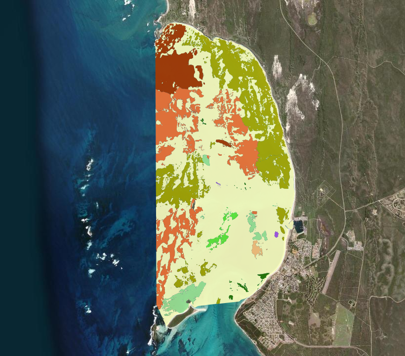
Mapping of benthic habitat and seafloor bathymetry of Lancelin, WA derived from satellite imagery captured on 17 July 2017 at a spatial resolution of 2 m. Mapping extent covered as much of the Defence gazetted waters as possible, to a depth of approximately 18 m based on water clarity. Recently dead or senesced (e.g. winter dieback of leaves) and mobile seagrass have the same satellite signature as live seagrass at spectral resolutions of the sensor (WorldView-2). This ensured areas of winter dieback and/or senescence were captured as areas of seagrass for the purposes of impact assessment.
-
Green turtles (Chelonia mydas) are globally endangered and culturally significant to Indigenous Traditional Owners in northern Australia, yet fine-scale understanding of their foraging habitats remains poorly understood, especially along Australia's remote north-coast. This project mapped green turtle foraging habitats in the Northern Territory, through collaboration with Indigenous Traditional Owners and ranger groups, to assist with their sea country management. Visual classifications of towed video transect data were used in a Support Vector Machine Learning Model to predict habitat in 379 km² of remotely sensed satellite imagery, overlapping the benthic habitats for two green turtle foraging grounds within the joint managed parks: Trepang Bay, Garig Gunak Barlu Marine Park, and Field Island, Kakadu National Park. Algae and seagrass made up 30% of the Trepang Bay and 18.05% of the Field Island foraging turtle habitat. The classification accuracy of the model showed a high level of agreement at both sites (0.63 for Trepang Bay and 0.75 for Field Island). These habitats provide good foraging grounds for green turtles and the diversity of marine habitats also allows for a range of different age classes of green turtles to use these sites for a range of other behaviours, e.g. resting and predator avoidance. The simplicity and repeatability of the field methods used in this study allow for future monitoring of marine habitats in remote areas by ranger groups. The findings are useful for conservation planning, including the development of management plans in the Northern Territory.
-
Mapping of benthic habitat and seafloor bathymetry of Swanbourne, WA derived from satellite imagery captured on 03 June 2017 at a spatial resolution of 2 m. Mapping extent covered as much of the Defence gazetted waters as possible, to a depth of approximately 18 m based on water clarity. Recently dead or senesced (e.g. winter dieback of leaves) and mobile seagrass have the same satellite signature as live seagrass at spectral resolutions of the sensor (WorldView-2). This ensured areas of winter dieback and/or senescence were captured as areas of seagrass for the purposes of impact assessment.
-
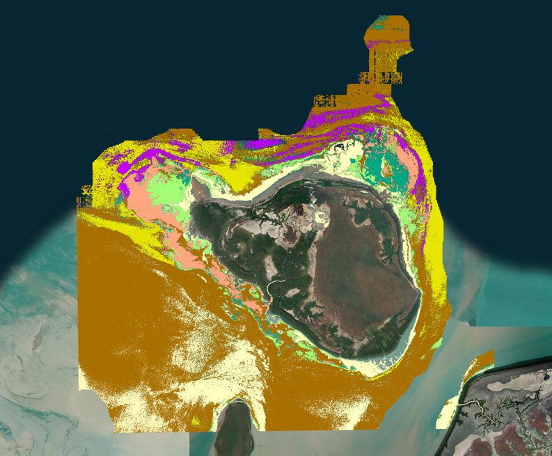
The coral reefs of Australia’s North West Kimberley Bioregion are both unique and internationally significant. They exist in one of the most extreme marine environments globally, characterised by the highest tidal range in the southern hemisphere, persistent turbidity, and frequent cyclones. These conditions have shaped coral reefs with distinct geomorphological attributes. The region’s remoteness has minimised direct anthropogenic pressures, but it also presents substantial logistical and financial challenges for data collection and fieldwork. To improve access to information about this region, a geodatabase termed 'ReefKIM' was developed. ReefKIM integrates diverse datasets into a single, comprehensive repository to support research and management. Sources include satellite imagery, orthophotos, bathymetric charts, sub-bottom profiles, geological maps, seabed geomorphology, reef cores, biophysical data, and extensive ground-truthing. This enabled consistent derivation of six broad feature classes: (1) reef extents (2) geomorphological zones (3) habitats and substrates (4) coastlines (5) island boundaries; and (6) other studies and work (e.g. ground truth points, survey, sample collections, coring sites, sub-bottom profiles, images) This record provides access to items (1), (2) and (3) of the ReefKIM components, collated for the purposes of the Seamap Australia National Benthic Habitat Mapping collaborative project. • Reef extents: 853 reef features with size, shape, and reef type attributes. • Geomorphological zones: Five standardised reef zones (land, reef flat, lagoon, reef crest, and fore-reef slope) mapped for 30 reefs. • Habitats and substrates: Seven habitat/substrate classes (mangroves, sand, seagrass and algae, coral rubble, reef pavement with algal turf, crustose coralline algae, and coral communities) mapped for 30 islands and reefs. Additional ReefKIM products are stored at the Pawsey Supercomputing Centre under: WA Node Ocean Data Network > WAMSI2 > KMRP > 1.3 > 1.3.1 A full directory is documented in '1.3.1_Folder_Structure.pdf' in 1.3.1>001_Metadata at https://storage.pawsey.org.au/public/projects
-
Mesopelagic microbes and zooplankton, degrade and attenuate >90% of the 10 billion tonnes of Particulate Organic Carbon (POC) that sinks into the oceans’ interior annually. Approaches such as particle interceptors/incubators (called C-RESPIRE) can isolate the microbial assemblage attached to particles from that of zooplankton, enabling quantification of microbially-mediated POC flux attenuation. This metric yields patterns of POC degradation by microbes through the upper mesopelagic (200-500 m depth). Here, we investigate the temporal sequence of POC degradation in two steps. First, we intercept sinking particle assemblages from different depths (180-300 m) and hence with varying degrees of exposure to microbial activity. Second, we incubate these intercepted particles shipboard for 12h (short-term) and track degradation using Apparent Respiratory Quotients (ARQ, dDIC/dDO2). We also incubate shipboard (12h) a particle assemblage previously incubated (36h) in situ using C-RESPIRE (long-term). At a subantarctic and two polar sites, ARQs from short-term incubations exhibited a significant decrease with depth, consistent with particles deeper in the upper mesopelagic being exposed to a longer period of degradation and flux attenuation (as they settle). ARQs from all long-term incubations had significantly lower ARQs, and smaller depth-dependent gradients, than the short-term incubations. We interpret these trends as being driven in part by sequential changes in the stoichiometry of the microbially-altered POC substrates. Several ARQs of <0.5 (less than the theoretical minimum) were observed in long-term incubations suggesting a role for incomplete oxidation of substrates. This temporal sequence is used to conceptually explore what sets the limits on microbially-mediated degradation of POC.