 IMAS Metadata Catalogue
EARTH SCIENCE | BIOSPHERE | ECOSYSTEMS | MARINE ECOSYSTEMS
Type of resources
Topics
Keywords
Contact for the resource
Provided by
Years
-
This resource contains access links to all data collected and and created under the ACE-CRC program. See 'online resources' section of this record for index of all online ACE-CRC data.
-
The goal of the program was developing comprehensive inventories and maps of the distribution and abundance of physical and biological seabed habitats, seagrasses and benthic assemblages to provide baseline environmental mapping and a description of ecological patterns. The benthic habitat mapping was performed by utilising R/Python and Maxent software within the species distribution modelling domain. We correlated the probability of occurrence of individual benthic habitat classes with the environmental predictors developed form the multibeam hydroacoustic dataset. The data is presented as a maximum likelihood map incorporating all five prediction classes: (1- Macroalgae; 2- Filter Feeders; 3- Seagrass; 4- Hard Corals; 5- Bare seafloor). An updated version of this data are available (2022) Revised predictive benthic habitat map for Darwin Harbour. Report prepared for Department of Environment, Parks and Water Security. Australian Institute of Marine Science, Darwin, 127 pp.
-
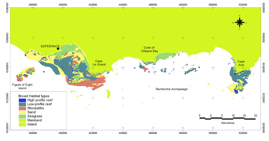
The Fisheries Research and Development Corporation Project (FRDC) No. 2001/060 characterised and identified the distribution of the different benthic habitats of the Recherche Archipelago and identified the distribution of assemblages of fish, mobile invertebrates, filter feeding communities and seagrasses and the patterns and processes which structure them. Benthic habitat were determined from the interpretation of Landsat imagery, sidescan sonar imagery and video validation data collected within the Recherche region from May 2002 to November 2003.
-
This project updates the 2019 predictive benthic habitat map for this region, extending past the subtidal zone of the harbour to include intertidal habitats. The project worked with collaborators to synthesise existing data sets for inclusion in benthic habitat mapping process. Hydrodynamic model variables were updated and new digital elevation data included to provide a more accurate representation of the bed shear stress, waves and current. LiDAR surveys were conducted to fill in the gap between the IX bathymetric survey and the high tide water mark. The LiDAR survey data extended the existing bathymetry data. A total of 30 towed video transects were conducted in areas predicted to have a high probability of benthic fauna occurrence based on the existing predictive model. The benthic habitat model was updated to include NTG historical data, new towed video data, hydrodynamic and light data.
-
Voyage IN2019_V04 contributed an additional 29,000 kms2 of seafloor survey data to the Coral Sea knowledge base. From this new bathymetric data individual seamounts have been extracted and have been classified to the Geoscience Australia Geomorphology Classification Scheme. This dataset contains two layers representing the classification layers- 1) Surface (Plain, Slope, Escarpment) and 2) fine scale Geomorphology of the seamount for the Mellish Seamount. Ongoing research with this survey data will provide new insights into the detailed geomorphic shape and spatial relationships between adjacent seabed features. This information will be released in future publications to show the potential of how the scale of such seafloor data can be used for predictive habitat modelling when analysed with the biological data overlays.
-
Voyage IN2019_V04 contributed an additional 29,000 kms2 of seafloor survey data to the Coral Sea knowledge base. From this new bathymetric data individual seamounts have been extracted and have been classified to the Geoscience Australia Geomorphology Classification Scheme. This dataset contains two layers representing the classification layers- 1) Surface (Plain, Slope, Escarpment) and 2) fine scale Geomorphology of the seamount for the Cassowary Seamount. Ongoing research with this survey data will provide new insights into the detailed geomorphic shape and spatial relationships between adjacent seabed features. This information will be released in future publications to show the potential of how the scale of such seafloor data can be used for predictive habitat modelling when analysed with the biological data overlays.
-
Voyage IN2019_V04 contributed an additional 29,000 kms2 of seafloor survey data to the Coral Sea knowledge base. From this new bathymetric data individual seamounts have been extracted and have been classified to the Geoscience Australia Geomorphology Classification Scheme. This dataset contains two layers representing the classification layers- 1) Surface (Plain, Slope, Escarpment) and 2) fine scale Geomorphology of the seamount for the Lexington Seamount. Ongoing research with this survey data will provide new insights into the detailed geomorphic shape and spatial relationships between adjacent seabed features. This information will be released in future publications to show the potential of how the scale of such seafloor data can be used for predictive habitat modelling when analysed with the biological data overlays.
-
Voyage IN2019_V04 contributed an additional 29,000 kms2 of seafloor survey data to the Coral Sea knowledge base. From this new bathymetric data individual seamounts have been extracted and have been classified to the Geoscience Australia Geomorphology Classification Scheme. This dataset contains two layers representing the classification layers- 1) Surface (Plain, Slope, Escarpment) and 2) fine scale Geomorphology of the seamount for the Calder Seamount. Ongoing research with this survey data will provide new insights into the detailed geomorphic shape and spatial relationships between adjacent seabed features. This information will be released in future publications to show the potential of how the scale of such seafloor data can be used for predictive habitat modelling when analysed with the biological data overlays.
-
Voyage IN2019_V04 contributed an additional 29,000 kms2 of seafloor survey data to the Coral Sea knowledge base. From this new bathymetric data individual seamounts have been extracted and have been classified to the Geoscience Australia Geomorphology Classification Scheme. This dataset contains two layers representing the classification layers- 1) Surface (Plain, Slope, Escarpment) and 2) fine scale Geomorphology of the seamount for the Kenn Seamount. Ongoing research with this survey data will provide new insights into the detailed geomorphic shape and spatial relationships between adjacent seabed features. This information will be released in future publications to show the potential of how the scale of such seafloor data can be used for predictive habitat modelling when analysed with the biological data overlays.
-
Voyage IN2019_V04 contributed an additional 29,000 kms2 of seafloor survey data to the Coral Sea knowledge base. From this new bathymetric data individual seamounts have been extracted and have been classified to the Geoscience Australia Geomorphology Classification Scheme. This dataset contains two layers representing the classification layers- 1) Surface (Plain, Slope, Escarpment) and 2) fine scale Geomorphology of the seamount for the Sula Seamount. Ongoing research with this survey data will provide new insights into the detailed geomorphic shape and spatial relationships between adjacent seabed features. This information will be released in future publications to show the potential of how the scale of such seafloor data can be used for predictive habitat modelling when analysed with the biological data overlays.