 IMAS Metadata Catalogue
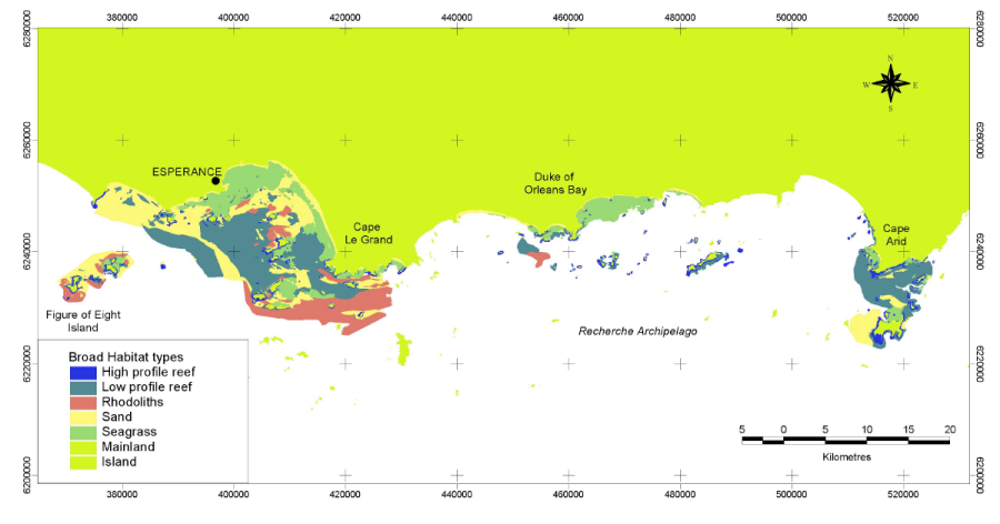
Characterising the fish habitats of the Recherche Archipelago - Benthic habitats (FRDC (2001/060)
The Fisheries Research and Development Corporation Project (FRDC) No. 2001/060 characterised and identified the distribution of the different benthic habitats of the Recherche Archipelago and identified the distribution of assemblages of fish, mobile invertebrates, filter feeding communities and seagrasses and the patterns and processes which structure them. Benthic habitat were determined from the interpretation of Landsat imagery, sidescan sonar imagery and video validation data collected within the Recherche region from May 2002 to November 2003.
Simple
Identification info
- Date (Creation)
- 2007-06-01
Principal investigator
Point of contact
- ISBN
- 1 74052 123 4
- Purpose
- OBJECTIVES 1. To identify, classify and map the distribution of, different benthic habitats in the Recherche Archipelago and link their distributions to bottom type and exposure to swells and currents. 2. To provide detailed ecological information to ensure the responsible management of aquaculture fisheries in the region. 3. To increase community awareness of fish habitats through community involvement in the development of baseline studies and ongoing monitoring programs.
- Credit
- Fisheries Research and Development Corporation (FRDC)
- Status
- Completed
Point of contact
Point of contact
- Topic category
-
- Oceans
- Biota
Extent
))
Temporal extent
- Time period
- 2002-05-01 2003-12-01
Vertical element
- Minimum value
- 0
- Maximum value
- 80
- Identifier
- EPSG::5715
- Name
- MSL depth
- Maintenance and update frequency
- Not planned
- NASA/GCMD Keywords, Version 8.5
Resource constraints
- Classification
- Unclassified
Resource constraints
- Linkage
-
http://i.creativecommons.org/l/by/4.0/88x31.png
License Graphic
- Title
- Creative Commons Attribution 4.0 International License
- Website
-
http://creativecommons.org/licenses/by/4.0/
License Text
- Other constraints
- Cite data as: Kendrick, G. & Harvey, E. (2003). Characterising the fish habitats of the Recherche Archipelago - Benthic habitats (FRDC (2001/060). University of Western Australia. Data accessed at https://metadata.imas.utas.edu.au/geonetwork/srv/eng/catalog.search#/metadata/3fd8fb49-a06a-40af-affc-e97e8e4c10e6 on [access date].
- Other constraints
- This dataset is a is hosted by the Institute for Marine and Antarctic Studies (IMAS), University of Tasmania, on behalf of the University of Western Australia (UWA) for the purposes of the Seamap Australia collaborative project.
- Language
- English
- Character encoding
- UTF8
- Supplemental Information
- Fisheries Research and Development Corporation Project No. 2001/060 ISBN: 1 74052 123 4 - Acknowledgements - The Esperance community has been involved throughout the project as individuals, businesses, community groups, and through the Recherche Advisory Group. The research group has prepared a web page, posters, articles in the popular magazines Landscope and Ecos, regular interviews on ABC Radio, TV and local newspaper articles, educational materials and regularly presented seminars and presentations in Esperance and Perth. The research group has been also involved in helping to run a Tuna Cage Fishing Public Workshop. All of this community activity has been continuously documented as outcomes of our communications strategy at each milestone to FRDC. As an extension of the FRDC (2001/060) biophysical survey a new program, to develop social and economic profiles of the Recherche Archipelago began in November 2004. Project Manager Neil Lazarow, from the Coastal Cooperative Research Centre (Coastal CRC) is consulting with the Esperance community to map current uses of the Archipelago by locals and visitors alike. This will include a profile of commercial and recreational fishing, tourist operations, commercial shipping and any other ways the Recherche Archipelago is currently used. Information obtained from this project will complement the environmental data obtained by the present three year FRDC project in which RAG has also been a partner. Funding for the project has come from the Department of Conservation and Land Management, RAG, Shire of Esperance and the Coastal CRC. This project has benefited enormously from the generosity of the Esperance community, whose help, advice and friendship have been instrumental in the development and implementation of the project. Our appreciation and thanks is extended to all who have helped and we specifically would like to thank the following: - Members of the Recherche Advisory Group (RAG) - All the volunteers from UWA and Esperance who assisted in the field - Ross Ainsworth, Sally Castledine and Jane Meiklejohn - Esperance Freight Lines - Colin Stewart and the Esperance Port Authority - Marcus and Michelle Gray - Peter and Deborah Brown - Bob and Judy Boord - Bernie Habberly - Fud and Faye Mackenzie - Elaine & Chris Siemer - Paul Rose - Kevin McNeil - Hendrick Rasmussen - Barry Mercer - Duke of Orleans Caravan Park - Neville Longbottom - Klaus Tiedemann, Tilo Massenbauer, Alan Rose, Conservation and Land Management (CALM), Esperance. - The staff of Moby Marine - Nick Middleton - Peter and Leslie Hudson - Fugro Survey Pty, Ltd for the generous loan of their Starfix satellite positioning system for the multibeam survey in October 2003. - Kevin Bancroft, Ray Lawrie and Mark Sheridan, Conservation and Land Management (CALM), Fremantle. We are also grateful to The Esperance Port Authority, MG Kailis, Portman Ltd and Outokumpou Technology Pty Ltd for cash contributions which made the research program viable.
Content Information
- Content type
- Physical measurement
- Description
- Appended to original data for styling purposes for the Seamap Australia Project.
- Name
- Benthic habitat
- Name
- SM_HAB_CLS
Distribution Information
- Distribution format
-
- ESRI shapefile (.shp)
- OnLine resource
- ASSOCIATED PUBLICATION - Final project report
- OnLine resource
-
SHAPE-ZIP
DATA ACCESS - This OGC WFS service returns the data (Recherche Archipelago benthic habitats) in Shapefile format.
- OnLine resource
-
SeamapAus_WA_Recherche_Archipelago_2003
MAP - Recherche Archipelago benthic habitats
- OnLine resource
- Browse & download associated project outputs on PAWSEY
Resource lineage
- Statement
- Habitat definition - The level to which a habitat can be classified will largely be determined by the resolution of the survey method used, although all types of survey methods should result in the same habitat classes or community definitions to allow cost-effective mapping across large areas. The hierarchical classification scheme developed for the Recherché allow habitats to be both broadly defined using remote sensing methods, such as Landsat or sidescan sonar, or in more detail using methods such as video, to determine factors, such as substrate type, relief and percent cover. For the purposes of this study, broad habitats defined include: low profile reef, high profile reef, dense seagrass, medium seagrass, sparse seagrass, sand, sand with medium vegetation, sand with sparse vegetation, rhodoliths and deep water sponge communities. Habitats have been broadly defined at the 1:100,000 cartographic scale, the minimum mapping unit being set at 100m. Habitat polygons have not been interpreted below this size for the purposes of the broadscale mapping required, although the nature of the data in specific locations allows much more detailed, functional habitats to be mapped (eg. using 1m resolution sidescan sonar or video data). Reliability measures - Within the attribute table, each polygon classified was tagged according to the data sources used to help define it (eg. sidescan, drop video, towed video, Landsat, Kirkman data - see individual metadata for source data accuracy). Reliability weightings can now be assigned to each polygon based on the inputs used to classify it. For example, Landsat imagery would be a more reliable source to classify habitats with, when accompanied by towed video or sidescan data, as opposed to areas that only have isolated drop camera footage. Habitat validation - Spatial datasets, such as sidescan and Landsat imagery, were interpreted to define habitat polygons within a Geographic Information System (GIS). Given the clarity of the water, the extent of large features could often be determined using Landsat at 30-40m in depth, although it was not known what the features were. Sidescan data was often then used to validate features visible on Landsat. For example, sidescan data was able to determine the presence of rhodolith beds, which otherwise were not distinguishable from what was expected to be low profile reef. Similarly, seagrass communities outlined using Landsat, were also further defined according to the degree of cover (eg. sparse, medium or dense seagrass) using both sidescan and video. In many cases, the video validated cover differences that were observable on the sidescan record. Classified video points were used to not only validate polygons but also where possible, extend the boundaries into areas that did not have spatial data inputs.
- Hierarchy level
- Dataset
Metadata
- Metadata identifier
- urn:uuid/3fd8fb49-a06a-40af-affc-e97e8e4c10e6
- Language
- English
- Character encoding
- UTF8
Distributor
- Parent metadata
Type of resource
- Resource scope
- Dataset
- Metadata linkage
-
https://catalogue.aodn.org.au:443/geonetwork/srv/api/records/3fd8fb49-a06a-40af-affc-e97e8e4c10e6
Point of truth URL of this metadata record
- Date info (Creation)
- 2017-11-21T18:11:31
- Date info (Revision)
- 2025-07-16T14:14:42
Metadata standard
- Title
- ISO 19115-3:2018
Overviews
Spatial extent
Provided by
