 IMAS Metadata Catalogue
National Environmental Science Program (NESP) Marine and Coastal Hub
Type of resources
Topics
Keywords
Contact for the resource
Provided by
Years
-
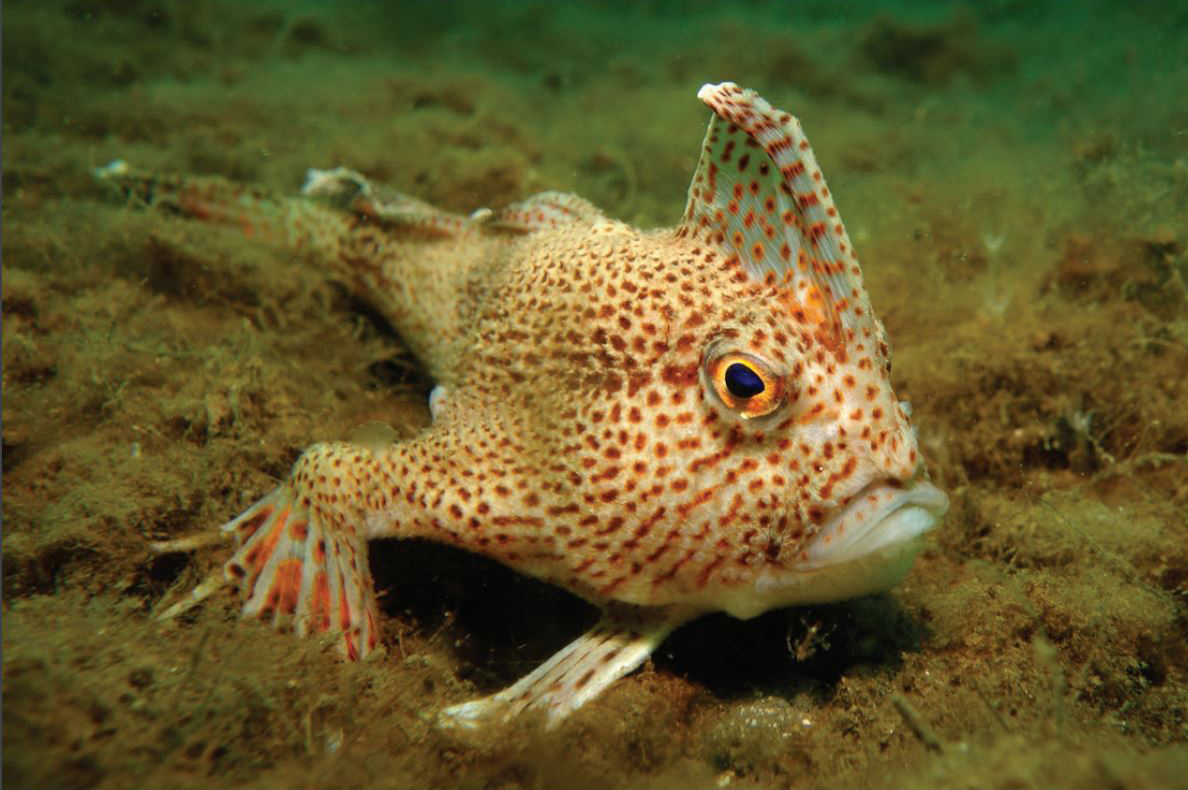
Dive surveys were conducted in 2014 and the same sites resurveyed annually until 2022 (excluding 2021), to establish a baseline and monitor the status of the critically endangered spotted handfish (Brachionichthys hirsutus) population. This dataset is a summary of all surveys season 2014 to 2022 (excluding 2021) in which the 11 sites across the Derwent Estuary and D'Entrecasteaux Channel were assessed. The data describes the search effort (transect length, swathed area) and counts of handfish observed on each transect, including size measurements (total length) and depth records for each sighted fish.
-
A review of peer-reviewed publications was undertaken, focusing on coastal and marine microplastics relevant to South Eastern Australia (South Australia, Victoria, and New South Wales), as well as from ongoing citizen science programmes from AUSMAP (https://www.ausmap.org/). This dataset summarises basic information about the microplastics studies: the location of the study; if the study focused on water, sediment or biota; the type of biota (for biotic studies); and the DOI of the publication. Although the primary focus of this study was restricted to southeastern Australia, studies collated from other regions have also been included in this dataset. The outcomes of the literature review for other regions (QLD, NT, SA, WA, Tas) should not be considered comprehensive.
-
This metadata record provides a brief overview of the National Environmental Science Program (NESP) Marine and Coastal (MaC) Hub. The record acts as an aggregation point for all NESP Marine and Coastal Hub data collections and projects developed as part of this research program. The National Environmental Science Program (NESP) is a long-term commitment by the Australian Government to environment and climate research. The first phase invested $145 million (2014-15 to 2020-21) into 6 research hubs. The second phase invests $149 million (2020-21 to 2026-27) into 4 new research hubs. The program builds on its predecessors – the National Environmental Research Program (NERP) and the Australian Climate Change Science Programme (ACCSP) – to support decision-makers to understand, manage and conserve Australia’s environment by funding world-class biodiversity and climate science. The Marine and Coastal Hub is a collaborative partnership supported by funding from the Australian Government administered by the Department of Climate Change, the Environment, Energy and Water (DCCEEW) - previously Department of Agriculture, Water and the Environment (DAWE). The current NESP funding program runs from 2021 to 2027. The Marine and Coastal Hub is co-administered by the University of Tasmania (UTAS), and the Reef and Rainforest Research Centre (RRRC). The Marine and Coastal Hub delivers: • applied research to support management of Australia’s marine and coastal environments including estuaries, coast, reefs, shelf and deep-water • targeted biodiversity and taxonomy products to support efficient system monitoring • environmental monitoring systems and decision-support tools. Research products from the NESP Marine and Coastal Hub are available from https://nespmarinecoastal.edu.au and the Australian Ocean Data Network catalogue (http://catalogue.aodn.org.au)
-
Seagrass beds are a dominant marine ecosystem of Tayaritja (the Furneaux Group of Islands) in the north-eastern waters off Tasmania. Historical coarse mapping has indicated extensive beds of Posidonia, Amphibolis, Heterozostera, and Zostera species, potentially comprising some of the largest and deepest seagrass extents found in temperate Australian waters. However, limited data on the distribution and ecological value of these seagrass habitats represents a significant knowledge gap in understanding Australia's wetland natural assets. This project mapped the extent, ecological composition, population structure, and blue carbon value of seagrass beds around Tayaritja. The study area focused on the coastal waters surrounding Flinders Island in the western Furneaux Group, with mapping extending from the high tide line to the depth limit of reliable optical detection (approximately 30 m), based on analysis of field data and satellite imagery capabilities in the region. The field validation component of this study involved deployment of benthic video platforms to capture imagery of seagrass beds and associated ecosystems. A field campaign deployed a Benthic Observation Survey System (BOSS) and unBaited Remote Underwater stereo-Video system (stereo-uBRUV) at approximately 400 locations to collect photoquadrats and validate remote sensing outputs. Imagery annotation was conducted in the SQUIDLE+ platform. The approach developed through this study contributed to the creation of the NESP Standard Operating Procedure (SOP) for Seagrass Mapping using Optical Remote Sensing (https://sustainabledevelopmentreform.github.io/nesp-sop-seagrass-mapping).. See the "Lineage" section of this record for full methodology of field collection techniques. See associated dataset https://doi.org/10.25959/e4s6-ge74 for habitat maps derived from field validation and remote sensing inputs.
-

This record provides an overview of the NESP Marine and Coastal Hub scoping study - "Scoping for an Australian Wetland Inventory: identifying knowledge gaps and solutions for mapping Australian marine and coastal wetlands". No data outputs were generated by this project. -------------------- Marine and coastal wetlands provide extensive ecosystem services—protecting shorelines, improving water quality, supporting healthy fisheries, promoting tourism, storing carbon, and holding cultural significance for Aboriginal and Torres Strait Islander people. Like many wetlands around the world, Australian wetlands continue to be threatened, degraded, and lost due to climate change, development, and other human activities. To support the Australian Government’s development of a national wetland inventory, this project assessed the current state of coastal wetland mapping across five key areas: seagrass, saltmarsh, intertidal macroalgae, shorebird habitat, and blue carbon. It identified major knowledge and inventory gaps through a combination of literature review and consultation with 73 end-users and experts, resulting in 25 targeted recommendations to guide future mapping and data integration. A summary of the status of mapping habitat attributes and ecosystem services such as blue carbon, coastal protection and shorebird habitat is available in the project's Final Technical Report. This report incudes recommendations to guide investment in high-demand areas and support nationally consistent wetland management and reporting to address key knowledge gaps. Outputs • Report reviewing and synthesising knowledge gaps in inventory mapping of marine and coastal wetlands, identifying effective solutions, and guiding subsequent research projects for enhancing wetland mapping [written]
-

This record provides an overview of the NESP Marine and Coastal Hub scoping study - "Research needs for assessment and monitoring of nutrients, chemicals and antimicrobials in the marine environment". No data outputs were generated by this project. -------------------- Coastal water quality is threatened by an increasing volume of chemicals produced and used in our modern lives. These chemicals are commonly incorporated into pharmaceuticals and household items, and subsequently discharged into coastal areas from a broad range of point sources. Recently emerging contaminants include a variety of chemical (e.g. heavy metals, pharmaceuticals, pesticides, nutrients) and microbiological (e.g. pathogens, antibiotic resistant microbes) sources that are discharged in sewage, stormwater, estuarine flows and industrial wastes. For many of these chemicals, our understanding of their environmental concentrations and biological effects is limited. When new scientific information emerges to suggest that a particular contaminant may be hazardous, this is refered to as a contaminant of emerging concern (CEC). There is limited data about the environmental occurrence and biological effects of CECs, but emerging research suggests they have the capacity to be toxic. With an increasing list of CECs detected in the environment, important questions remain unanswered around which contaminants and scientific knowledge gaps should be prioritised. This desktop study engaged CEC stakeholders from academic research, government, water utilities, and non-government organisations to collaboratively identify priority CEC issues in Australia’s marine ecosystems. The project delivers a risk-based framework for future CEC research directions and water quality management priorities. Outputs • Final Project Report [written]
-
Tidal wetlands are vulnerable to accelerated rates of sea-level rise projected by climate models. Assessing the resilience, or vulnerability, of these environments requires measurements of rates of vertical accretion, subsidence and elevation gain across a range of coastal settings. The Surface Elevation Table (SET) technique is applied globally to assess the extent of vertical adjustment of tidal wetlands to sea-level rise over decadal timescales. This enables measurement of whether wetlands are keeping pace with sea level rise (measured at tide gauges), or subsiding relative to local sea level rise and thus vulnerable to permanent inundation and loss. Australia’s network of Surface Elevation Tables is one of the most extensive in the world, consisting of over 200 benchmark monitoring stations from Westernport Bay, Victoria to Darwin Harbour, NT. This record describes the consolidated SET data collated from the Australian network (OzSET) as at 2022. This data can be used for analysing change to the elevation of wetlands wetlands at the study sites encompassed by OzSET.
-
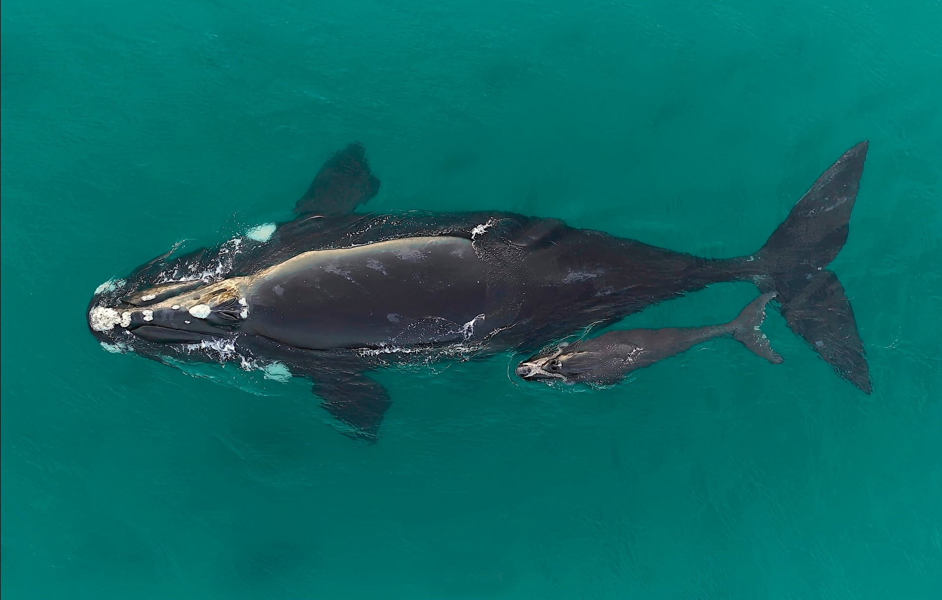
Aerial surveys of southern right whales (Eubalaena australis) were undertaken off the southern Australian coast to monitor the recovery of this endangered species following extreme 19th and 20th Century commercial whaling. The aerial survey was undertaken in the coastal waters from Perth (Western Australia) to Ceduna (South Australia) between the 12th and 17th August 2021, to maintain the annual series of surveys and inform the long-term population trend. The maximum whale counts for each leg of the survey flights between Cape Leeuwin and Ceduna, and consisted of a total 643 southern right whales sighted across the survey area (270 cow-calf pairs and 103 unaccompanied whales). The subsequent population estimate for the Australian ‘south-western’ population is 2,549 whales, which represents the majority of the Australian population given the very low numbers in the ‘south-eastern’ subpopulation. The population long-term trend data is indicating recent years (from 2007) are showing greater inter-annual variation in whale counts. To evaluate the recovery of the southern right whale population, it will be critical to collect long-term data on the annual variability in whale numbers related to the non-annual female breeding cycle and identify possible impacts on this by short-term climate dynamics, longer-term climate change and/or anthropogenic threats.
-

This record provides an overview of the NESP Marine and Coastal Hub small-scale study - "Towards a consolidated and open-science framework for restoration monitoring". No data outputs were generated by this project. -------------------- Coastal habitat restoration is scaling up rapidly in Australia and covers a range of diverse ecosystems including oyster reefs, seagrass meadows, mangrove forests, kelp forests, and saltmarshes. While monitoring is commonly included in these projects, approaches are often uncoordinated, inconsistently funded, and rarely follow open science protocols. Previous NESP-funded projects have advanced understanding of the ecology and service provision of threatened ecosystems and established targets for repair based on reference conditions (e.g. Marine Biodiversity Hub project B4). They also created a national database of marine and coastal restoration projects (Australian Coastal Restoration Network: project E5) and supported the development of monitoring, evaluation, reporting and improvement (MERI) systems across various sectors. Building on this foundation, the current project synthesised monitoring approaches across multiple habitat types by drawing on the collective expertise of Australian researchers. It also explored the integration of emerging technologies—such as automation, artificial intelligence, and eDNA—to improve monitoring efficiency and cost-effectiveness. The primary output of this project is a coordinated, open-science monitoring framework that incorporates clearly defined restoration goals and a core set of universal variables. Developed through expert consultation, the framework supports consistent benchmarking across projects while accommodating habitat-specific and goal-driven metrics. The framework promotes data accessibility, standardised definitions, and the integration of new technologies to streamline the development of future restoration projects and maximise the value of restoration monitoring. Outputs • Best-practice toolkit / final project report [written]
-
Predictions of dominant habitats were completed as part of a report funded by the NESP Marine & Coastal Hub. This report focussed on an IUCN II zone in the South-west Corner Marine Park off the 'Capes region' near Margaret River. This modelling contains data from stereo Baited Remote Underwater Video and panoramic drop camera, and was completed using the FSS-GAM package in R. Predictions are at two different scales and resolutions, one using the broad 250 metre resolution Geoscience Australia 2009 bathymetry grid (http://dx.doi.org/10.4225/25/53D99B6581B9A) and the other using a 5 metre resolution Geoscience Australia multibeam survey (https://dx.doi.org/10.26186/145281).