 IMAS Metadata Catalogue
MERI
Type of resources
Topics
Keywords
Contact for the resource
Provided by
Years
-
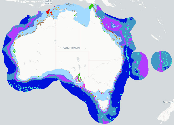
The Parks Australia Management Effectiveness (ME) system - previously MERI - is underpinned by a controlled, common language that provides a nationally consistent lexicon for a) Natural, cultural, and heritage values; (b) Social, cultural, and economic benefits; (c) Activities and anthropogenic pressures; and (d) Biophysical, and social and economic drivers. The Natural Values component of the common language is defined at three levels: 1) ecosystem complexes; 2) ecosystems; and 3) ecosystem components. This map shows the Ecosystems (tier 2) component of the Natural Values, and delineates features by habitat and depth for the Australian Exclusive Economic Zone (EEZ). This version (2022) of the National Values Ecosystems dataset uses Geoscience Australia's 250m resolution Australian Bathymetry and Topography Grid, 2009 (https://dx.doi.org/10.4225/25/53D99B6581B9A) as the basis for the map. See Hayes et al. 2021 and Dunstan et al. 2023 for a full definition of Natural Values Ecosystem terms, input datasets used, and processing steps involved with the creation of this map. Note that this dataset uses a combination of input data sources and interpolates where data gaps exist. The common language adopts a functional, largely geo-physical perspective to define surrogates for marine ecosystems. This dataset is not a substitute for a validated habitat map (see Seamap Australia National Benthic Habitat Layer: https://metadata.imas.utas.edu.au/geonetwork/srv/eng/catalog.search#/metadata/4739e4b0-4dba-4ec5-b658-02c09f27ab9a), but has a national coverage and provides valuable broad-scale categorisation of marine ecosystems in Australian waters. ***An updated version of this data product is available - see https://doi.org/10.25959/7SXA-DX47***
-
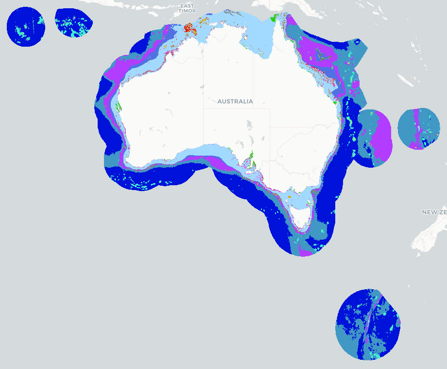
The Parks Australia Management Effectiveness (ME) system - previously MERI - is underpinned by a controlled, common language that provides a nationally consistent lexicon for a) Natural, cultural, and heritage values; (b) Social, cultural, and economic benefits; (c) Activities and anthropogenic pressures; and (d) Biophysical, and social and economic drivers. The Natural Values component of the common language is defined at three levels: 1) ecosystem complexes; 2) ecosystems; and 3) ecosystem components. This map shows the Ecosystems (tier 2) component of the Natural Values, and delineates features by habitat and depth for the Australian Exclusive Economic Zone (EEZ). This version (2025) of the National Values Ecosystems dataset uses Geoscience Australia's 250m resolution AusBathyTopo 2024 grid as the basis for the map. The dataset is an interim product between the 2022 version (https://doi.org/10.25959/HEKR-NR42) and an upcoming 2026 revision. The 2025 update incorporates revised and improved input datasets that have become available since the previous release. Several classification rules were updated to align with these inputs, including the use of Seamap Australia National Benthic Habitat Layer data as the primary source for mapped seagrass and coral reef occurrence. Note that this dataset uses a combination of input data sources and interpolates where data gaps exist. The common language adopts a functional, largely geo-physical perspective to define surrogates for marine ecosystems. This dataset is not a substitute for a validated habitat map (see Seamap Australia National Benthic Habitat Layer: https://metadata.imas.utas.edu.au/geonetwork/srv/eng/catalog.search#/metadata/4739e4b0-4dba-4ec5-b658-02c09f27ab9a), but has a national coverage and provides valuable broad-scale categorisation of marine ecosystems in Australian waters. See Hayes et al. 2021 and Dunstan et al. 2023 for a full definition of the Natural Values Ecosystem terms. See the 'lineage' section of this record for full processing notes.
-

The Parks Australia Management Effectiveness (ME) system - previously MERI - is underpinned by a controlled, common language that provides a nationally consistent lexicon for a) Natural, cultural, and heritage values; (b) Social, cultural, and economic benefits; (c) Activities and anthropogenic pressures; and (d) Biophysical, and social and economic drivers. The Natural Values component of the common language is defined at three levels: 1) ecosystem complexes; 2) ecosystems; and 3) ecosystem components. This map shows the Ecosystems (tier 2) component of the Natural Values, and delineates features by habitat and depth for the Australian Exclusive Economic Zone (EEZ). This version (2026) of the National Values Ecosystems dataset uses Geoscience Australia's 250m resolution AusBathyTopo 2024 grid as the basis for the map. The dataset is currently in draft format and may be updated at any time. The 2026 update incorporates revised and improved input datasets that have become available since the previous release. Several classification rules were updated to align with these inputs, including the use of Seamap Australia National Benthic Habitat Layer data as the primary source for mapped seagrass and coral reef occurrence. Note that this dataset uses a combination of input data sources and interpolates where data gaps exist. The common language adopts a functional, largely geo-physical perspective to define surrogates for marine ecosystems. This dataset is not a substitute for a validated habitat map (see Seamap Australia National Benthic Habitat Layer: https://metadata.imas.utas.edu.au/geonetwork/srv/eng/catalog.search#/metadata/4739e4b0-4dba-4ec5-b658-02c09f27ab9a), but has a national coverage and provides valuable broad-scale categorisation of marine ecosystems in Australian waters. See Hayes et al. 2021 and Dunstan et al. 2023 for a full definition of the Natural Values Ecosystem terms. See the 'lineage' section of this record for full processing notes.
-
This record provides an overview of the scope and research output of the NESP Marine Biodiversity Hub project "Supporting the Monitoring, Evaluation, Reporting and Improvement System for Australian Marine Parks". No data outputs were generated by this project. -------------------- This application is to facilitate Hub engagement with Parks Australia during development and initiation of their Monitoring, Evaluation, Reporting and Improvement (MERI) System for Australian Marine Parks. A key priority for the Marine Parks Branch in the 2019-20 financial year is finalising the Australian Marine Park MERI system. The Marine Biodiversity Hub will play an important role in development and implementation of this system. Hub partners have had previous experience in developing the integrated monitoring framework for the Great Barrier Reef, developing a process for identifying indicators for monitoring Key Ecological Features, and also have collected much of the ecological data that exists within Australian Marine Parks. In discussions with Parks Australia, to ensure the MERI system is optimally integrated with current scientific knowledge and capability, there are a number of tasks and information needs that the Hub is well positioned to provide assistance with, these include: • Review the ‘common language’ proposed for Australian Marine Parks, including natural values and pressures classifications, hierarchies and definitions. • Contribute to the identification of natural values, pressures and human uses within Australian Marine Parks and, where required, provide spatial data layers for incorporation into Parks Australia’s spatial information systems (i.e. Wylie) and other mapping portals. • Review conceptual models developed for each of the key ecosystems across the Australian Marine Park networks. • Review ecological risk assessments for natural values and pressures. • Provide advice on the process and criteria for identifying monitoring and inventory priorities. • Develop detailed conceptual models for areas identified as monitoring priorities. • Contribute to the development of monitoring questions. • Provide advice on the process and selection criteria for identifying appropriate value and pressure indicators (noting that the NESP D6 project is helping to identify appropriate social and economic indicators and measures). • Provide advice on best practice approaches for assessing management effectiveness. • Identify the suitability of existing data sets to support the identified monitoring priorities. • Provide advice on evaluation and reporting including best approaches for using a combination of quantitative data and expert opinion, and to help ensure alignment and consistency across objectives, key evaluation questions and reporting.
-
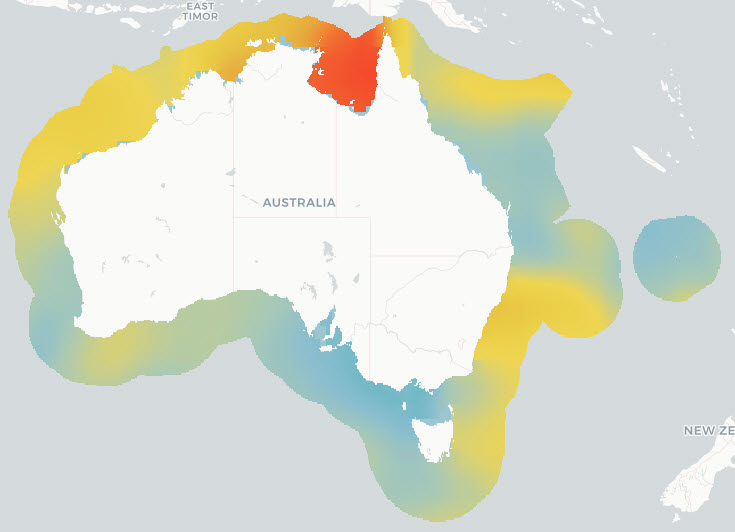
The National Environmental Science Program projects SS2 and D7 (under the Marine Biodiversity Hub) and 1.3 (under the Marine and Coastal Hub) were instigated to support the design of Monitoring Effectiveness (ME) framework for Australian Marine Park (AMP) estate, and contribute to the AMP Science Plan. The overall objective of these projects was to provide a nationally accepted common language to describe natural values and pressures, and a robust approach to combining this information to inform national priorities for monitoring inside AMPs. Broadly, the following approach was taken: 1. Identify Key Natural Values (KNVs) in AMP networks through an expert elicitation process, 2. Develop a national-scale ecosystem map via a combination of depth and characteristic habitat using the ME framework 3. Collate and synthesise pressures operating within Australia’s Exclusive Economic Zone and state/territory waters, as defined by the ME framework's pressures common language 4. Provide a spatially explicit analysis of the relative risks posed to marine conservation values, as defined by the ME framework’s natural values hierarchy. This record describes component 3: collating the pressures by ME common language for all of Australia’s Exclusive Economic Zone and state/territory waters; and determining the cumulative pressure exerted by each activity/sub-activity combination. Components 1, 2 & 4 are described elsewhere.
-
This record provides an overview of the NESP Marine and Coastal Hub bridging study - "Support for Parks Australia’s Monitoring, Evaluation, Reporting and Improvement System for Australian Marine Parks". For specific data outputs from this project, please see child records associated with this metadata. -------------------- The system of marine parks that spans Australia’s Commonwealth waters is among the largest in the world. These parks play a major role in conserving marine life, supporting commercial and recreational activities, and protecting cultural values significant to Aboriginal and Torres Strait Islander peoples. Parks Australia has developed management plans for five regional Australian Marine Park (AMP) networks (North, North-west, South-west, South-east and Temperate East) and the Coral Sea Marine Park (CSMP). Under each management plan, a science plan sets priorities for monitoring and research to evaluate management effectiveness and identify opportunities for improvement. This prioritisation is vital given the limited knowledge across many AMPs, the technical challenges and high costs of science in remote areas, and the finite resources available for park management. Building on foundational work from the NESP Marine Biodiversity Hub (projects SS2 and D7), this project delivered the scientific and technical advice needed to establish monitoring priorities for natural values and pressures across all AMP networks and the CSMP—completing a full national priority list for monitoring. It applied a nationally consistent four-step prioritisation framework that considered ecological importance, vulnerability to pressures, baseline data availability, and logistical feasibility. The project also updated the National Ecosystem model and Pressures & Activities datasets, conducted expert vulnerability assessments, and produced a Relative Cumulative Impact index. The combined research delivers a nationally accepted "common language" to describe natural values and pressures and a science-based method to derive monitoring priorities, aligned with the Monitoring, Evaluation, Reporting and Improvement (MERI) system—an adaptive management framework that is globally unique and a significant step towards adaptive, integrated, place-based management. Key outputs include a national database of environmental and human-use data for each management region and a refined list of monitoring priorities for each AMP Network and the CSMP. The findings highlight major knowledge gaps—particularly in the distribution of mesophotic and rariphotic reefs, intertidal ecosystems, and recreational fishing impacts—and provide guidance for improving baseline data and pressure assessments. The prioritisation framework and data products developed through this project can be re-generated over time alongside improvements in the evidence base and our understanding of how ecosystems respond to multi-sectoral activities to support continual improvement in iterative, evidence-based park management and environmental outcomes. Outputs • Digital map layers per AMP network of: (1) Ecosystems; (2) Pressures & Activities; and (3) Cumulative Benthic & Pelagic Impacts • Final Technical Report containing maps of Key Natural Values, and of spatial Monitoring Priorities, including a short summary of recommendations for policy makers of key findings [written]