 IMAS Metadata Catalogue
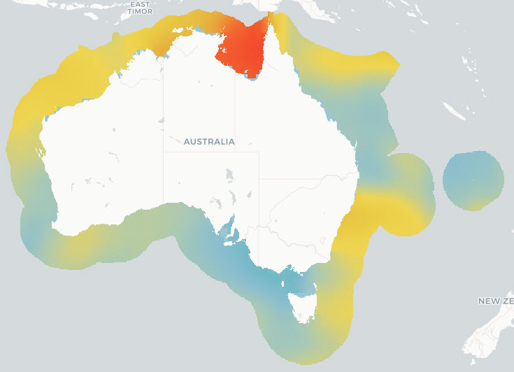
Marine pressures operating within Australia’s Exclusive Economic Zone (NESP MaC 1.3)
The National Environmental Science Program projects SS2 and D7 (under the Marine Biodiversity Hub) and 1.3 (under the Marine and Coastal Hub) were instigated to support the design of Monitoring Effectiveness (ME) framework for Australian Marine Park (AMP) estate, and contribute to the AMP Science Plan.
The overall objective of these projects was to provide a nationally accepted common language to describe natural values and pressures, and a robust approach to combining this information to inform national priorities for monitoring inside AMPs. Broadly, the following approach was taken:
1. Identify Key Natural Values (KNVs) in AMP networks through an expert elicitation process,
2. Develop a national-scale ecosystem map via a combination of depth and characteristic habitat using the ME framework
3. Collate and synthesise pressures operating within Australia’s Exclusive Economic Zone and state/territory waters, as defined by the ME framework's pressures common language
4. Provide a spatially explicit analysis of the relative risks posed to marine conservation values, as defined by the ME framework’s natural values hierarchy.
This record describes component 3: collating the pressures by ME common language for all of Australia’s Exclusive Economic Zone and state/territory waters; and determining the cumulative pressure exerted by each activity/sub-activity combination.
Components 1, 2 & 4 are described elsewhere.
Simple
Identification info
- Date (Creation)
- 2023-08-24
- Edition
- Version 1
Identifier
- Title
- Information and documentation - Digital object identifier system
- Citation identifier
- ISO 26324:2012
- Code
- 10.25959/NMVE-SF04
- Codespace
- doi.org
- Description
- Digital Object Identifier (DOI)
Principal investigator
- Credit
- The data collections described in this record are funded by the Australian Government Department of Climate Change, Energy, the Environment and Water (DCCEEW) through the NESP Marine and Coastal Hub. In addition to NESP (DCCEEW) funding, this project is matched by an equivalent amount of in-kind support and co-investment from project partners and collaborators.
- Status
- Completed
Point of contact
- Topic category
-
- Biota
- Environment
- Oceans
- Society
Extent

Temporal extent
- Time period
- 2016-01-01
Vertical element
- Minimum value
- 0
- Maximum value
- 7000
- Identifier
- EPSG::5715
- Name
- MSL depth
- Maintenance and update frequency
- As needed
- Keywords (Project)
-
- National Environmental Science Program (NESP) Marine and Coastal Hub
- Keywords (Theme)
-
- research
- monitoring
- cumulative pressures
- Management Effectiveness (ME)
- MERI
- priorities
- GCMD Earth Science Keywords
Resource constraints
- Classification
- Unclassified
Resource constraints
- Other constraints
- This dataset is hosted by the Institute for Marine and Antarctic Studies (IMAS), University of Tasmania, on behalf of CSIRO and NESP Marine and Coastal Hub Project 1.3.
Resource constraints
- Linkage
-
http://i.creativecommons.org/l/by/4.0/88x31.png
License Graphic
- Title
- Creative Commons Attribution 4.0 International License
- Website
-
http://creativecommons.org/licenses/by/4.0/
License Text
- Other constraints
- Cite data as: Dunstan, P., & Hayes, K. (2023). Marine pressures operating within Australia’s Exclusive Economic Zone (Version 1.0) [Data set]. Institute for Marine and Antarctic Studies. https://doi.org/10.25959/NMVE-SF04
Associated resource
- Title
- NESP MaC Project 1.3 - Support for Parks Australia’s Monitoring, Evaluation, Reporting and Improvement System for Australian Marine Parks, 2021-2022 (CSIRO)
Identifier
- Association Type
- Dependency
- Initiative Type
- Project
- Language
- English
- Character encoding
- UTF8
- Supplemental Information
- Dunstan PK, Woolley SNC, Monk J, Barrett N, Hayes KR, Foster S, Howe SA, Logan D, Samson CR, Francis SO (2023) Designing a targeted monitoring program to support evidence-based management of Australian Marine Parks: National Implementation. Report to the National Environmental Science Program. CSIRO. Hayes, K. R., Dunstan, P., Woolley, S., Barrett, N., Howe, S. A., Samson, C. R., Bowling, R., Ryan, M. P., Foster, S., Monk, J., Peel, D., Hosack, G. R., Francis, S. O. (2021). Designing a Targeted Monitoring Program to Support Evidence Based Management of Australian Marine Parks: A Pilot on the South-East Marine Parks Network. Report to Parks Australia and the National Environmental Science Program, Marine Biodiversity Hub. Parks Australia, University of Tasmanian and CSIRO, Hobart, Australia.
Distribution Information
- Distribution format
-
- Web Map Service, ESRI Shapefile
- OnLine resource
- DATA ACCESS - browse and selectively download available data
- OnLine resource
- DATA ACCESS - directly download full data package
- OnLine resource
-
View mapping layers in the Seamap Australia portal
NOTE: there are 30+ pressures outputs from this project, choose your layers of interest in Seamap Australia by selecting 'Pressures & Activities' > and all sub-categories suffixed with '[summed]' for summed pressures.
Resource lineage
- Statement
- Pressures were collated from a wide range of sources and allocated to the corresponding Activity and Sub-activity according to the ME framework common language (see reports linked to this record). Wherever possible (and permissible) each pressure data product was mapped to a 0.1 degree (approximately 10 km²) grid resolution raster, resulting in 309,870 cells across the commonwealth marine area. Each data product was then standardised to a maximum value of 1, and averaged over the period of time that the data was available. If more than one component pressure was present for a single sub-activity, these were summed, before re-standardising into a dimensionless 0-1 Standardised Pressure Sum (SPS). Data is available in raster format in the following folder structure -Activity --Sub-activity ----raw [original component pressure rasters] ----standardised [component pressure rasters scaled 0-1 and expanded + masked to Aus EEZ] ----SPS [sum of all component pressure rasters, rescaled 0-1] See Dunstan et al 2023 & Hayes et al 2021 for a description of individual sub-activities and full methodology.
- Hierarchy level
- Dataset
Metadata
- Metadata identifier
- urn:uuid/054d861c-72d0-4923-9375-d81bc1ae7f85
- Language
- English
- Character encoding
- UTF8
Point of contact
Type of resource
- Resource scope
- Dataset
- Metadata linkage
-
https://metadata.imas.utas.edu.au/geonetwork/srv/eng/catalog.search#/metadata/054d861c-72d0-4923-9375-d81bc1ae7f85
Point of truth URL of this metadata record
- Date info (Creation)
- 2023-08-24T11:44:25
- Date info (Revision)
- 2026-05-31T11:48:20
Metadata standard
- Title
- ISO 19115-3:2018
Overviews
Spatial extent

Provided by
