 IMAS Metadata Catalogue
Deakin University
Type of resources
Topics
Keywords
Contact for the resource
Provided by
Years
-
This project undertook a review of existing environmental literature and data on threatened and migratory marine species data to inform the sustainable development of Offshore Renewable Energy (ORE) projects (primarily wind) in Australia. A list of priority species and species of secondary importance were identified by the project together with stakeholders from DCCEEW and NOPSEMA. This list comprised of 100 species of birds, cetaceans, bony fish, sharks, pinnipeds and marine turtles. A literature search was undertaken for each species using a systematic approach detailed in the 'Lineage' section of this record. Each publication was assessed for whether the study location was within or near the ORE area and an attribute populated to indicate the ORE area(s) overlapped. Studies with spatial coverages not overlapping the ORE area were still retained if they were located nearby the ORE area, for species with poorly-defined distributions (e.g. short-finned pilot whales), or for migratory coastal birds that may use the ORE area as migration corridors. The potential impacts of ORE infrastructure and operation for each species was noted from a controlled list of potential impacts. The main topic of the study, and the methodologies used in the study, were also recorded, along with the general spatial location(s) of the study and the publication citation. The resultant inventory serves as a comprehensive record of existing publications associated with priority species potentially at risk from ORE developments, along with the nature of the potential impact. The inventory is intended to provide research information and methods for use in the planning, development, operation, and decommissioning phases of the offshore wind sector. The dataset attached to this record provides a spatial index of of all publications identified through this inventory process. Observation data each of the species were additionally compiled from BirdLife Australia, Atlas of Living Australia (ALA), Ocean Biodiversity Information System (OBIS), Victorian Biodiversity Atlas Victorian Biodiversity Atlas (VBA), and GlobalArchive (a repository of stereo-video annotations data). These data are freely available to download from each of the source repositories.
-

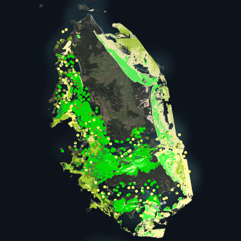
Seagrass beds are a dominant marine ecosystem of Tayaritja (the Furneaux Group of Islands) in the north-eastern waters off Tasmania. Historical coarse mapping has indicated extensive beds of Posidonia, Amphibolis, Heterozostera, and Zostera species, potentially comprising some of the largest and deepest seagrass extents found in temperate Australian waters. However, limited data on the distribution and ecological value of these seagrass habitats represents a significant knowledge gap in understanding Australia's wetland natural assets. This project mapped the extent, ecological composition, population structure, and blue carbon value of seagrass beds around Tayaritja, in partnership with the Tasmanian Aboriginal Centre. The study area focused on the coastal waters surrounding Flinders Island in the western Furneaux Group, with mapping extending from the high tide line to the depth limit of reliable optical detection (approximately 30 m), based on analysis of field data and satellite imagery capabilities in the region. This record specifically describes the benthic mapping component of the study. See https://doi.org/10.25959/WRXK-KV06 for imagery annotation data from the field validation campaigns. A combination of close-range remote sensing methods was used to map the extent and ecological values of seagrass beds. The approach developed through this study contributed to the creation of the NESP Standard Operating Procedure (SOP) for Seagrass Mapping using Optical Remote Sensing (https://sustainabledevelopmentreform.github.io/nesp-sop-seagrass-mapping).. High-resolution satellite imagery from Sentinel-2 (10 m) sensors, combined with bathymetric LiDAR data and oceanographic variables, was used to map baseline seagrass extent and composition. A field campaign deployed a Benthic Observation Survey System (BOSS) and unBaited Remote Underwater stereo-Video system (stereo-uBRUV) at approximately 400 locations to validate remote sensing outputs. From these data, maps were produced showing the extent and coverage of seagrass, sand, and macroalgae, and where possible, seagrass species composition, subject to water depth and clarity constraints. See the "Lineage" section of this record for full methodology. Three key types of mapping products were developed: ---Occurrence probability maps--- Continuous probability surfaces (0-100%), modelled from presence/absence data, indicating the likelihood of habitat presence at each pixel for: • Seagrass (all morphologies; > 5% cover observed in underwater field imagery) • Macroalgae species/assemblages • Sand ---Habitat percentage cover maps--- Quantitative estimates of percent cover for each habitat category: • Seagrass (all morphologies) • Macroalgae species/assemblages • Sand ---Derived products--- • Baseline binary presence/extent maps derived from optimised probability thresholds: ○ Seagrass: sgprob > 0.5 & sgprob > macroprob & sandcover < 0.9 ○ Macroalgae: macroprob > 0.5 & macroprob > sgprob & sandcover < 0.9 ○ Sand: sandprob > 0.5 & sandcover < 0.2 • Predicted seagrass species composition of binary extent map. • Fractional cover visualisation: combining cover percentages of multiple habitats into a single composite product • Composite habitat maps: combining binary habitat extents and delineating mixed habitat classes These complementary products serve different purposes: probability maps provide confidence measures, extent maps delineate habitat boundaries, percent cover maps support quantitative analysis of habitat density patterns, and composite habitat maps represent the diversity of mixed habitat classes. Together, they provide a comprehensive understanding of seagrass and associated habitat distribution across the study area.
-
***This record contains a subset of benthic habitat data from https://doi.org/10.25959/E4S6-GE74 (NESP MaC Project 3.6) rehosted for the purposes of the Seamap Australia collaborative project.*** Seagrass beds are a dominant marine ecosystem of Tayaritja (the Furneaux Group of Islands) in the north-eastern waters off Tasmania. Historical coarse mapping has indicated extensive beds of Posidonia, Amphibolis, Heterozostera, and Zostera species, potentially comprising some of the largest and deepest seagrass extents found in temperate Australian waters. However, limited data on the distribution and ecological value of these seagrass habitats represents a significant knowledge gap in understanding Australia's wetland natural assets. This project mapped the extent, ecological composition, population structure, and blue carbon value of seagrass beds around Tayaritja, in partnership with the Tasmanian Aboriginal Centre, as part of NESP Marine and Coastal Hub Project 3.6. The study area focused on the coastal waters surrounding Flinders Island in the western Furneaux Group, with mapping extending from the high tide line to the depth limit of reliable optical detection (approximately 30 m), based on analysis of field data and satellite imagery capabilities in the region. This metadata record specifically describes the benthic mapping component of the study. A combination of close-range remote sensing methods was used to map the extent and ecological values of seagrass beds. High-resolution satellite imagery from Sentinel-2 (10 m) sensors, combined with bathymetric LiDAR data and oceanographic variables, was used to map baseline seagrass extent and composition. A field campaign deployed a Benthic Observation Survey System (BOSS) and unBaited Remote Underwater stereo-Video system (stereo-uBRUV) at approximately 400 locations to validate remote sensing outputs, collecting field photo quadrats and rhizome cores. From these data, maps were produced showing the extent and coverage of seagrass, sand, and macroalgae, and where possible, seagrass species composition, subject to water depth and clarity constraints. See the "Lineage" section of this record for full methodology.
-

This record provides an overview of the NESP Marine and Coastal Hub Research Plan 2023 project "Guiding the sustainable development of offshore renewables and other emerging marine industries in Australia". For specific data outputs from this project, please see child records associated with this metadata. -------------------- Australia is entering a phase of rapid offshore renewable energy development, particularly offshore wind, with priority areas identified across the western, southern and eastern coasts. Regulatory assessment under the EPBC Act and Offshore Electricity Infrastructure Act requires accessible environmental, cultural and monitoring information to support socially and ecologically sustainable development. This project established inventories of existing environmental and cultural data, best-practice monitoring standards, and impact-related literature for continental shelf waters associated with Australia’s six priority offshore wind regions: Hunter and Illawarra, Gippsland, Southern Ocean, Bass Strait, and the Indian Ocean off Bunbury. The process was guided by an Offshore Renewable Energy Program Steering Committee with representatives from DCCEEW, NOPSEMA and Marine and Coastal Hub partners. The work ran in parallel with a related NESP Marine and Coastal Hub project (https://www.nespmarinecoastal.edu.au/project/3-21) focused on the confirmed area of declaration for ORE off the east Gippsland coast, Victoria. Together, both projects were guided by an Offshore Renewable Energy Program Steering Committee comprising representatives from DCCEEW, NOPSEMA and Marine and Coastal Hub partners. Focus areas of the data inventory were: • Seabed geomorphology, bathymetry, sedimentology, and habitat characterisation; • Oceanographic features and coastal processes; • Priority threatened, migratory, and marine species and habitats; • Potential impacts during installation, operation, and decommissioning; • Indigenous communities and cultural values affected by ORE development areas; • Monitoring needs and associated best practices. Project outputs included four database inventories with more than 500 publications across 16 impact types, seabed and oceanographic information, and tabulated summaries and mapped extents of priority species relevant to ORE assessment. The compiled data inventories identified major data and management gaps, including limited high-resolution bathymetry, geomorphology and biological survey data; inconsistent data acquisition standards; limited FAIR access to threatened species data; and the need for coordinated research investment and early Traditional Owner engagement. Outputs from the project will support environmental assessment, mitigation and monitoring of offshore wind impacts, standardisation of data collection methodologies, cumulative impact assessment, and regulatory decision-making under the EPBC and OEI Acts. Outputs • Inventory of existing information and associated sources for the following thematic areas: seabed geomorphology and habitat, oceanography, species and habitats, affected indigenous communities, ongoing monitoring needs and associated best practices, potential impacts of installation and operation [data inventories] • Final project report [written]
-
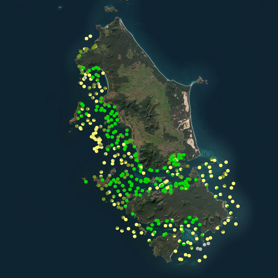
Seagrass beds are a dominant marine ecosystem of Tayaritja (the Furneaux Group of Islands) in the north-eastern waters off Tasmania. Historical coarse mapping has indicated extensive beds of Posidonia, Amphibolis, Heterozostera, and Zostera species, potentially comprising some of the largest and deepest seagrass extents found in temperate Australian waters. However, limited data on the distribution and ecological value of these seagrass habitats represents a significant knowledge gap in understanding Australia's wetland natural assets. This project mapped the extent, ecological composition, population structure, and blue carbon value of seagrass beds around Tayaritja. The study area focused on the coastal waters surrounding Flinders Island in the western Furneaux Group, with mapping extending from the high tide line to the depth limit of reliable optical detection (approximately 30 m), based on analysis of field data and satellite imagery capabilities in the region. The field validation component of this study involved deployment of benthic video platforms to capture imagery of seagrass beds and associated ecosystems. A field campaign deployed a Benthic Observation Survey System (BOSS) and unBaited Remote Underwater stereo-Video system (stereo-uBRUV) at approximately 400 locations to collect photoquadrats and validate remote sensing outputs. Imagery annotation was conducted in the SQUIDLE+ platform. The approach developed through this study contributed to the creation of the NESP Standard Operating Procedure (SOP) for Seagrass Mapping using Optical Remote Sensing (https://sustainabledevelopmentreform.github.io/nesp-sop-seagrass-mapping).. See the "Lineage" section of this record for full methodology of field collection techniques. See associated dataset https://doi.org/10.25959/e4s6-ge74 for habitat maps derived from field validation and remote sensing inputs.
-
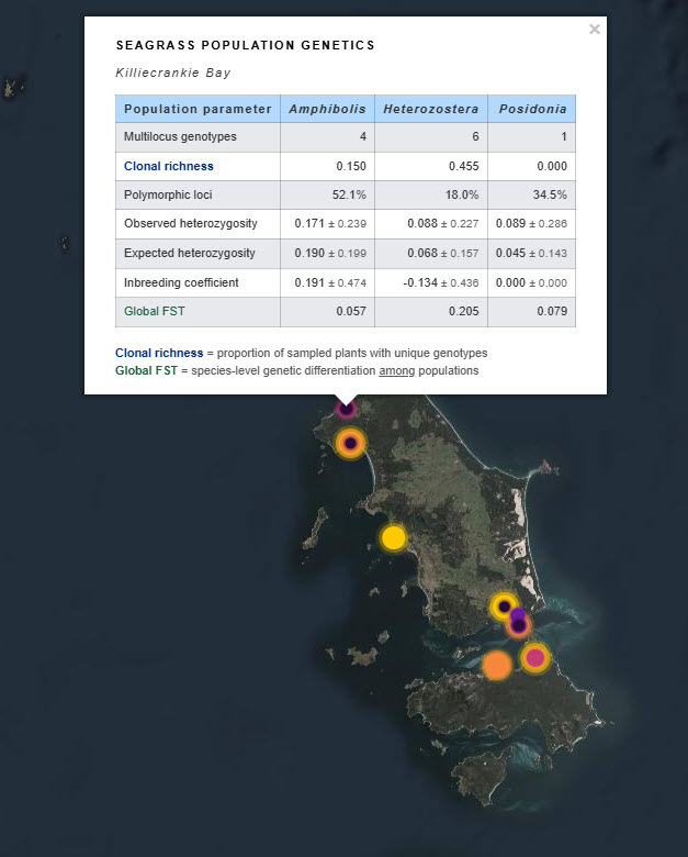
Seagrass beds are a dominant marine ecosystem of Tayaritja (the Furneaux Group of Islands) in the north-eastern waters off Tasmania. Historical coarse mapping has indicated extensive beds of Posidonia, Amphibolis, Heterozostera, and Zostera species, potentially comprising some of the largest and deepest seagrass extents found in temperate Australian waters. However, limited data on the distribution and ecological value of these seagrass habitats represents a significant knowledge gap in understanding Australia's wetland natural assets. This project mapped the extent, ecological composition, population structure, and blue carbon value of seagrass beds around Tayaritja, in partnership with the Tasmanian Aboriginal Centre. This record specifically describes the seagrass population genetics component of the project. Leaf tissue samples were collected from four seagrass species: Amphibolis antarctica, Heterozostera nigricaulis, Posidonia australis and Zostera muelleri. Samples were collected from multiple sites around Tayaritja Sea Country and processed for genome-wide SNP genotyping using the DArTseq platform. The dataset includes population-level genetic summary statistics, associated DArT metadata and reports, and raw sequence data used to support assessment of genetic diversity, clonality, population structure and connectivity among sampled seagrass populations. See the "Lineage" section of this record for full methodology. ***EMBARGO NOTE*** Data is currently embargoed until 31/12/2026. Please contact the NESP Data Wrangler (Southern node) to discuss access options: Emma.Flukes@utas.edu.au
-
This record provides an overview of the NESP Marine and Coastal Hub Research Plan 2023 project "Exploring the distribution and ecological value of seagrass at the Furneaux Islands, Tasmania". For specific data outputs from this project, please see child records associated with this metadata. -------------------- Seagrass meadows are a dominant marine ecosystem of Tayaritja (the Furneaux Group of Islands) in north-eastern Tasmania. Historical coarse-scale mapping indicated extensive beds of Posidonia, Amphibolis, Heterozostera and Zostera, with the Posidonia and Amphibiolis beds being potentially some of the largest and deepest extents in temperate Australian waters. These habitats provide ecological, social, cultural and economic values, including habitat for fish and for maireener shells used by Pakana people for traditional necklace making. This project worked in partnership with the Tasmanian Aboriginal Centre (TAC) to improve knowledge of seagrass extent, composition, population structure, ecological condition and blue carbon value around Tayaritja. Existing data were collated to guide survey design for mapping, and high-resolution satellite remote sensing was used to map seagrass beds down to a depth of approximately 30 metres, including intertidal lagoon systems associated with the Logan Lagoon Ramsar site. Field surveys, including video observations and rhizome coring, were used to validate satellite-derived maps and collect ecological samples. Outputs from this project include spatial layers of seagrass extent, variability and species composition, classified using the Seamap Australia National Benthic Habitat Classification Scheme. Rhizome samples were used to assess blue carbon storage, genetic connectivity and diversity, population structure, reproductive strategies, and relationships between seagrass, animal and microbial communities in shallow waters. The project developed new standards-based approaches for collecting, analysing, managing and reporting seagrass data, alongside training and guidance for the TAC land and sea management team and Pakana Rangers. The resulting methods and datasets will support Indigenous-led monitoring and management of the proposed Tayaritja Sea Country Indigenous Protected Area (IPA), and improve understanding of wetland values relevant to Ramsar reporting and future blue carbon opportunities. Outputs • Seagrass extent and composition map for Furneaux group [dataset] • Seagrass imagery and associated seafloor annotations [dataset] • Final project report [written]
-
The Victorian seabed habitat map documents the distribution of broad benthic habitat types in Victorian Coastal Waters to the State’s 3 nautical mile jurisdictional limit. The map was created using a top-down modelling process whereby habitat descriptors were assigned using seafloor structure and biological information derived from multibeam sonar (Victorian Marine Habitat Mapping Project), bathymetric LiDAR (Future Coasts program) and observations from underwater video. Identification of benthic biota, to the lowest discernible taxonomic level, and substrate characteristics were recorded according to the Victorian Towed Video Classification scheme (Ierodiaconou et al. 2007).
-
This dataset has been superseded by https://metadata.imas.utas.edu.au/geonetwork/srv/eng/catalog.search#/metadata/0145df96-3847-474b-8b63-a66f0e03ff54 (Victorian Statewide Marine Habitat Map 2023). The Victorian Benthic Habitats - Western Port Bay (CBICS) is a synthesis of all existing benthic habitat characterisations of the embayment which have been reclassified to conform to the Combined Biotope Classification Scheme (CBiCS). Base layers for the synthesised dataset were sourced from data provided by: Marine and Freshwater Resources Institute, Queenscliff, Victoria Institute for Sustainability and Innovation, Victoria University, Melbourne. Parks Victoria, Victorian Government Deakin University, Victoria Department of Environment, Land, Water and Planning, Victorian Government
-
This dataset has been superseded by https://metadata.imas.utas.edu.au/geonetwork/srv/eng/catalog.search#/metadata/0145df96-3847-474b-8b63-a66f0e03ff54 (Victorian Statewide Marine Habitat Map 2023). The Victorian Benthic Habitats - Port Phillip Bay (CBICS) is a synthesis of all existing benthic habitat characterisations of the embayment which have been reclassified to conform to the Combined Biotope Classification Scheme (CBiCS). Base information for the synthesised dataset were sourced from data provided by: Marine and Freshwater Resources Institute, Queenscliff, Victoria Institute for Sustainability and Innovation, Victoria University, Melbourne. Parks Victoria, Victorian Government Deakin University, Victoria Department of Environment, Land, Water and Planning, Victorian Government