 IMAS Metadata Catalogue
Wildlife and Habitat Management
Type of resources
Topics
Keywords
Contact for the resource
Provided by
Years
-

This record provides an overview of the scope and research output of the NESP Marine Biodiversity Hub project "The status of human-shark interactions and initiatives to mitigate risk in Australia". For specific data outputs from this project, please see child records associated with this metadata. -------------------- Considerable political, public and media attention has recently been focussed on human-shark interactions, specifically surrounding shark attack and ways to mitigate this risk. Finding the most appropriate policy balance between conservation of sharks, maximising public safety and understanding the broader social and economic ramifications/drivers for doing so is a continuing challenge for Government. This project will review the status of human-shark interactions in Australia, provide a synthesis of current initiatives to reduce risk, review recent international efforts to address these issues and identify knowledge gaps to provide an informed base for determining the most appropriate future research and policy support. The project will develop a background document that: • Provides a synthesis of the current state of knowledge of shark-human interactions in Australia, focussing specifically on species such as white sharks, bull sharks and tiger sharks • Identifies what initiatives are currently underway nationally to address human-shark interactions including the status of current research as well as current management and policy initiatives. • Identifies technological developments within Australia and internationally in this space • Identifies lessons and experiences from these initiatives • Identifies issues and knowledge gaps • Provides guidance to the Department regarding further investment that is cognisant of State Government initiatives and requirements and ensure a coordinated national knowledge base for addressing these issues
-
Wedge-tailed shearwaters (Ardenna pacifica) are widely distributed across tropical and subtropical oceans, with their breeding range recently extending south. For populations at their southernmost extent, habitat use, segregation, and trophic niche remain poorly understood. In this study we investigated the habitat use, segregation, and trophic niche in two disjunct populations of wedge-tailed shearwaters in eastern Australia, located at temperate and subtropical latitudes, between 2015 and 2019. Both populations exhibited consistent spatial segregation across all years of the study. Individuals from the temperate population consistently used waters off southeastern Australia, with a pre-staging detour towards the subtropical frontal zone before their winter migration to the western Pacific Ocean, in the Philippine Sea. At the same time, subtropical conspecifics exploited waters further east and north, with a proportion undertaking a pre-staging detour only in the first year. Stable isotope analysis (δ15N and δ13C) of chick feathers further revealed trophic and habitat segregation between colonies, with the subtropical population consistently occupying a smaller trophic niche area and exhibiting lower interannual variation across all years. Both populations exhibited a high degree of interannual variability in foraging strategies and trophic niches, indicating a capacity for behavioural adaptivity in response to prey availability and oceanic conditions. This adaptability may facilitate future range shifts into temperate habitats, which is important given projected climate-driven changes to ocean dynamics in southeastern Australia.
-
We hypothesised that New Zealand sea lions from Campbell Island/Motu Ihupuku of various sex and age classes would utilise the water column differently due to differing physiological constraints and therefore have different accessibility to prey resources. We tested whether sea lion diving behaviour varied in relation to (i) age and sex class, (ii) time of day and (iii) water depth. We also hypothesized that the proportion of benthic/pelagic diving, and consequently risk of fisheries interaction, would vary in relation to age and sex. Satellite telemetry tags were deployed on 25 NZSL from a range of age/sex classes recording dive depth, duration and location. Adult females and juveniles used inshore, benthic habitats, while sub-adult males also utilised benthic habitats, they predominantly used pelagic habitat at greater distances from the island. Adult females and juveniles exhibited shorter dives than the same age/sex classes at the Auckland Islands, suggesting a lower dive effort for these age/sex classes at Campbell Island.
-

This record provides an overview of the scope of the NESP Marine Biodiversity Hub project "Conservation status of tropical inshore dolphins". No data outputs were generated by this project. -------------------- This project reviewed current knowledge on Australia’s tropical inshore dolphins to inform future assessment of their conservation status. It focused on the Australian humpback dolphin (Sousa sahulensis), snubfin dolphin (Orcaella heinsohni), Indo-Pacific bottlenose dolphin (Tursiops aduncus) and the spinner dolphin (Stenella longirostris) complex. The project was undertaken as a desktop review of peer-reviewed literature, research projects and reports, including environmental impact assessments associated with major port developments from 2013 to 2019. It synthesised available information on species distribution, abundance, trends, habitat use, population structure and anthropogenic threats. The review found that knowledge had improved for several tropical inshore dolphin species, but was uneven across regions and species. Available data were largely concentrated in discrete study areas, limiting national-scale assessment. Identified threats included habitat loss and degradation associated with coastal development, bycatch in fishing gear and shark nets, and climate change impacts such as ocean warming, acidification and extreme weather events. Key recommendations included the use of scenario modelling and sensitivity analysis to support assessment of national population size and conservation status under uncertainty.
-
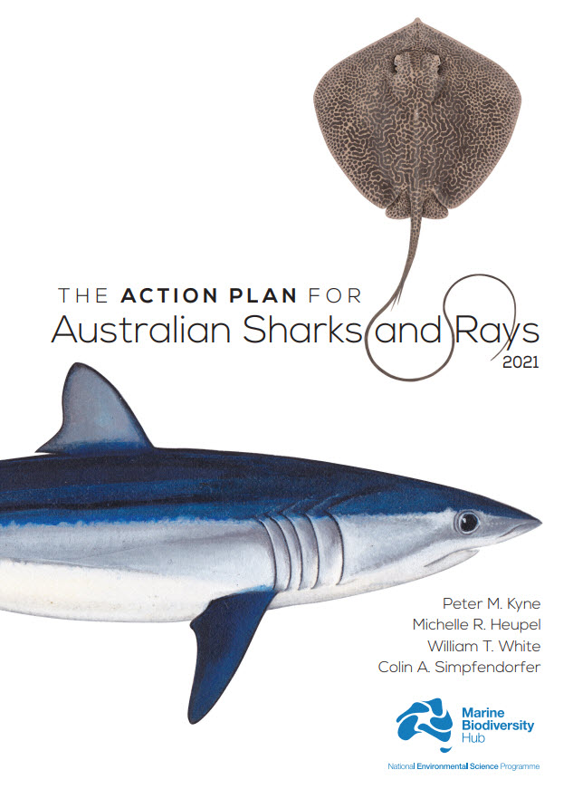
Australia is home to a quarter of the world’s cartilaginous fishes (Class Chondrichthyes) with 328 species consisting of 182 sharks, 132 rays, and 14 chimaeras. Australia’s first Shark Action Plan aims to provide a comprehensive and consistent review of the extinction risk of all cartilaginous fishes (hereafter ‘sharks’) occurring in Australian waters, to provide a benchmark from which changes in population and risk can be measured, and to help guide management for their conservation. This Action Plan also serves to raise the profile of their diversity and conservation needs. This volume includes a taxa profile for each of the 328 species occurring in Australian marine and inland waters, including external territories. Each species’ extinction risk was assessed by applying the IUCN Red List Categories and Criteria at the national level. Assessments of extinction risk consider all available information on a species’ taxonomy, distribution, population status, habitat and ecology, major threats, use and trade, and conservation measures. The IUCN Red List Categories and Criteria utilise a series of thresholds to evaluate extinction risk based on population size reduction, geographic range, population size, or the probability of extinction. Species were assessed against the five Red List criteria; to qualify for one of the three threatened categories (Critically Endangered, Endangered, or Vulnerable), a species had to meet a quantitative threshold for that category in any of the five criteria. The overall status of sharks in Australia is characterised by a relatively low level of extinction risk and a high level of secure species. Of the 328 species, 12% are threatened (39 species: 22 sharks, 17 rays; no chimaeras are threatened); 10% are Near Threatened (32 species: 18 sharks, 13 rays, 1 chimaera); 70% are Least Concern (231 species: 123 sharks, 95 rays, 13 chimaeras); and, 8% are Data Deficient (26 species: 19 sharks, 7 rays, no chimaeras are Data Deficient). No species are Extinct or Extinct in the Wild. Each taxa profile specifies two sets of actions for a species: actions to address knowledge gaps, and actions to maintain, secure, and if necessary, recover the population. To improve the ability to accurately assess the status of species, and ultimately, better conserve and manage them, all species treated in this Action Plan require some knowledge gaps be filled. Knowledge gaps are divided into five themes, each of which improves the information base from which to assess status: taxonomy, distribution, population trend, life history, and connectivity. Conservation actions are provided for each species, regardless of the status assigned them in this Action Plan. While threatened species require immediate action to conserve, manage, and recover their populations, Least Concern species also require action to maintain their secure status. Data Deficient species require action to understand various aspects of their population, but since an assessment as Data Deficient acknowledges the possibility that future research may show that a threatened classification is appropriate, action is also needed to minimise or mitigate threats until such time as more information is available to show that the species is not threatened. Finally, an overarching recommendation is provided for each threatened species. This includes the recommendation that five species be considered for listing on the Environment Protection and Biodiversity Conservation Act (EPBC Act), three species be considered for up-listing, and two species be considered for down-listing. An additional 12 threatened species have been identified as priorities for data collection where further data are required to strengthen the evidence-base underlying their status determinations. These species are priorities for research and monitoring to provide data to support inferred or suspected population reductions or continuing declines identified in the Action Plan. The implementation of the recommendations and actions in this Action Plan will require an ongoing and enhanced investment in science and management which will help secure the future of Australia’s sharks, rays, and chimaeras.
-
Wedge-tailed shearwaters (Ardenna pacifica) are widely distributed across tropical and subtropical oceans, with their breeding range recently extending south. For populations at their southernmost extent, habitat use, segregation, and trophic niche remain poorly understood. In this study we investigated the habitat use, segregation, and trophic niche in two disjunct populations of wedge-tailed shearwaters in eastern Australia, located at temperate and subtropical latitudes, between 2015 and 2019. Both populations exhibited consistent spatial segregation across all years of the study. Individuals from the temperate population consistently used waters off southeastern Australia, with a pre-staging detour towards the subtropical frontal zone before their winter migration to the western Pacific Ocean, in the Philippine Sea. At the same time, subtropical conspecifics exploited waters further east and north, with a proportion undertaking a pre-staging detour only in the first year. Stable isotope analysis (δ15N and δ13C) of chick feathers further revealed trophic and habitat segregation between colonies, with the subtropical population consistently occupying a smaller trophic niche area and exhibiting lower interannual variation across all years. Both populations exhibited a high degree of interannual variability in foraging strategies and trophic niches, indicating a capacity for behavioural adaptivity in response to prey availability and oceanic conditions. This adaptability may facilitate future range shifts into temperate habitats, which is important given projected climate-driven changes to ocean dynamics in southeastern Australia.
-

This record provides an overview of the scope and research data outputs of the NESP Marine Biodiversity Hub project "Characterising anthropogenic underwater noise to better understand and manage impacts to marine life". For specific data outputs from this project, please see child records associated with this metadata. -------------------- Shipping noise is a marine pollutant that contributes significantly to the marine soundscape and is a stressor of marine animals, particularly marine mammals. In Australia, the characterisation and actual impacts of shipping noise on species behaviour are not clearly understood and information is needed. This research will provide quantitative spatial and temporal maps of shipping noise to inform on noise exposure and impacts to MNES within the EEZ and in WHA’s. The outputs will provide key information to marine management agencies such as DoEE, AMSA and GBRMPA to help them meet responsibilities and obligations under international and national law and policy to minimise the impacts of shipping noise on MNES. Planned Outputs • A suite of maps of chronic shipping noise for key areas and species of concern, identifying key management areas and gross polluters. • A database of ship source spectra for predominant large vessels • A paper on improved methods or ambient noise estimation • Report on the quantification of shipping noise on Matters of National Environmental Significance • Final report on the characterisation of shipping noise in Australia
-
This record provides an overview of the scope and research data outputs of the NESP Marine Biodiversity Hub project "Surveying marine life in the canyons off Bremer Bay". For specific data outputs from this project, please see child records associated with this metadata. -------------------- The Bremer Canyon system is a recognised aggregation area for marine wildlife and predictable aggregations of the orca (Orcinus orca) underpin local ecotourism. Additionally, the value of the region has been recognised in the establishment of the Bremer Commonwealth Marine Reserve (CMR) (https://www.environment.gov.au/topics/marine/marine-reserves/south-west/bremer) and the identification of the Albany canyon group and adjacent shelf break as a Key Ecological Feature in the South-West Marine Bioregional Plan (https://www.environment.gov.au/sprat-public/action/kef/view/23;jsessionid=01AD87551D0DE1B0248C8722BE137004). Little is known about the shelf and canyon region given its remote location and the relatively high cost of conducting offshore research. However, citizen-driven science has documented a stable aggregation of marine wildlife including orcas, sperm whales (Physeter microcephalus), and giant squid (Architeuthis sp.) occurring to the west of the established CMR. There is also speculation that this stable wildlife aggregation may be driven by seabed oil seeps with a hydrocarbon-based food chain although this is unsubstantiated. The potential uniqueness of this wildlife aggregation within the region and what drives its presence remains unknown. There is a significant need to determine the regional importance of this aggregation and its relation to the existing protection afforded by the Bremer CMR. The objective of this project is to improve the understanding of the importance of the Bremer CMR and surrounding region to marine wildlife. The project will determine the distribution of key wildlife of interest across the recognised pelagic aggregation and the Bremer CMR in order to inform Australian Government decision-making to protect the environment, conserve biodiversity and allow for sustainable use. The project will also improve understanding about the likely causes for wildlife aggregations and provide recommendations for future research options. Planned Outputs • A workshop of key experts, managers and external stakeholders to build on the literature review, identify additional data sources and recommend research priorities; • A workshop report including a literature review to synthesise existing information, data and publications on the region in relation to wildlife aggregations, general ecology, oceanography and productivity; • Marine wildlife survey – given the need to cover a large spatial area (i.e. the CMR and the known aggregation area in a single day), the preferred method is for an aerial survey with two observers. We propose that the team mobilises from Esperance given proximity to the CMR and ability to refuel etc. A team of two (2) scientific observers will be included plus an opportunity for an additional observer. The research will involve five (5) days of aerial surveying over no more than a seven (7) day period. The project will investigate the occurrence and distribution of orcas both inside and outside the known aggregation area (including the Bremer CMR). • Analysis of existing acoustic data – Curtin University holds data from acoustic surveys and will interpret these data in the context of distinguishing the presence and distribution of orcas, other cetaceans and other biota. • Analysis of existing orca distribution data within the aggregation – Curtin University has previously collected data on visual sightings of orcas at the aggregation. These data will be the spatial and temporal distribution of orcas at the aggregation site. This has the capacity to identify key patterns in orca behaviour within the known aggregation area. • Collation of orca observations held by ecotourism operator Naturaliste Charter – this collation will provide the opportunity to determine how best to use these data and generate communication products given the collection of imagery. • Pelagic fish survey – an existing planned survey to the Bremer CMR will be extended to include the aggregation area to allow the diversity, abundance and biomass of pelagic sharks and fishes in the CMR and the aggregation area to be compared. This will allow a comparison of the relative richness of the known aggregation area to the CMR with respect to pelagic shark and fish abundance. • Hydrocarbon signals in squid - Preliminary investigation into whether hydrocarbon signals can be detected in squid as a first step in determining whether the wildlife aggregation may be supported by hydrocarbon seeps. Murdoch University hold squid samples from the aggregation area that form the basis of this analysis. • Movement data to determine how adult orcas use the Bremer CMR and the aggregation area - tags will also be placed on at least three (3) adult orcas from the known aggregation site to clarify if those individual orcas are also transiting or using the Bremer CMR. • Knowledge exchange and communication outputs – each component of the project will produce materials for use by Parks Australia. Likely considerations are 3D fly-thru, animations, infographics, brochure, videos, articles. • Reporting outputs – a progress report focussing on completed field work and preliminary results will be produced followed by a final synthesis report.
-

This record provides an overview of the scope and research data outputs of the NESP Marine Biodiversity Hub project "Assisting the restoration of seagrasses at Shark Bay". For specific data outputs from this project, please see child records associated with this metadata. -------------------- This project is a collaboration between scientists and the Shark Bay Malgana Indigenous community into jointly developed seeding and shoot planting methods to assist natural recovery of seagrasses in preparation for future devastating impacts of climate change. The Shark Bay World Heritage Site (WHS) is unique globally for its natural values, including stromatolites, seagrass meadows and marine megafauna including dugongs, sharks, turtles, and dolphins. The immediate goal is to scale up the existing restoration research to assist recovery of the dominant seagrasses, Amphibolis antarctica and Posidonia australis following the 2011 marine heat wave. Planned Outputs • A seagrass restoration toolkit (multimedia and report format) - will include information on sourcing suitable genetic material • Data on the trial seed restoration outcomes
-

This record provides an overview of the scope of the NESP Marine Biodiversity Hub project "Microplastics in the Australian marine environment". No data outputs were generated by project. -------------------- A literature review will firstly identify key marine microplastics research and policy development internationally, with a focus on research that is contextual to microplastics in the Australian marine environment From this literature review, an options paper will be developed to explore the most feasible and impactful policy approaches for the Australian context to reduce both intentionally added and not intentionally added microplastics in the marine environment (it would be beneficial to understand the policy options that can address both categories of microplastics because the options are different). These two reports would form the basis of a one day workshop that will draw together policy-makers, researchers and relevant industry peak bodies to discuss and recommend policy and other options to limit the release / impact of microplastics in the environment. A workshop report will be drafted to summarise findings, recommendations, and next steps (including identifying gaps in both science and policy will inform any future work required). The report will provide evidence to underpin the development of national policy aimed at reducing microplastic pollution, including by identifying priority actions to deliver Australia’s 2018 National Waste Policy .