 IMAS Metadata Catalogue
Marine Geoscience
Type of resources
Topics
Keywords
Contact for the resource
Provided by
Years
-
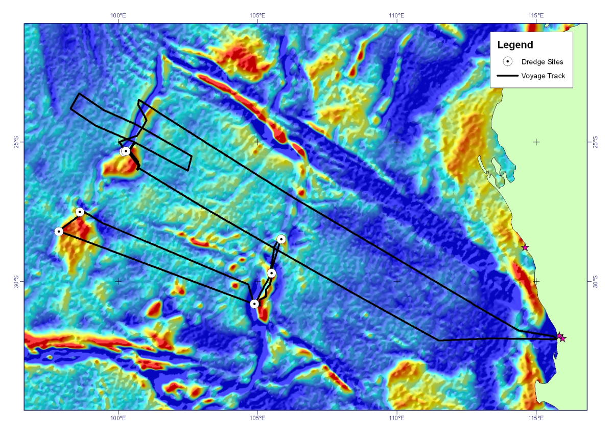
Dredge rocks were recovered on scientific voyage SS2011_06 on the MNF RV Southern Surveyor, from the Perth Abyssal Plain, offshore Western Australia. Continental rocks (gneiss, granite, sandstone) were dredged from both the Batavia Knoll and the Gulden Draak Ridge (dredge sites 1, 2, and 3). A small amount of high weathered basalt was recovered from the Gulden Draak Ridge (dredge site 4). Three successful dredges were undertaken along the Dirck Hartog Ridge recovering predominantly gabbro (dredge 5) and basalts (dredge sites 6 and 7).
-
The final lithospheric breakup of the Australian-Antarctic rift system remains controversial due to sparse geological constraints on the nature of the basement along the ocean-continent transition zones. We present new interpretations of multichannel seismic reflection transects, as well as new petrological data of dredged mantle rocks along the East Antarctic margin (Seamount B, offshore Terre Adélie). By combining both datasets, we show that a 50–100 km wide domain of cold (900°C), fertile subcontinental mantle was exhumed along the non-volcanic Antarctic margin. The dredged peridotites preserve characteristics similar to mantle xenoliths found in syn- to post-rift volcanism at the eastern end of the Australian margin (Victoria and Tasmania), indicating the sampling of a common fertile subcontinental mantle during rifting between Australia and Antarctica. Seamount B represents the initial stages of exhumation of cold subcontinental lithosphere along an ocean-continent transition during rifting. This thick mantle domain was likely affected by syn-rift melt impregnation at high-pressure (8 kbar), leading to the formation of plagioclase-pyroxenites. Overall, the combination of continental rifted blocks, a 50-100 km wide domain of volcanic-poor subcontinental mantle and (ultra)-slow spreading implies that ocean-continent transition zones along the Australian-Antarctic margins represent a recent analogue to ocean continent transition zones from the Jurassic Western Tethys. Additionally, evidence of syn-rift melt stagnation at high pressure suggests that magmatism along the Australian-Antarctic rifted margins was sufficient to form magnetic anomalies that can be used as isochrons despite their formation in lithosphere other than mature, steady-state ocean crust.
-
This dataset provides the spatially continuous data of seabed gravel (sediment fraction >2000 µm), mud (sediment fraction < 63 µm) and sand content (sediment fraction 63-2000 µm) expressed as a weight percentage ranging from 0 to 100%, presented in 10 m resolution raster grids format and ascii text file.</p> The dataset covers the eight areas in the Timor Sea region in the Australian continental EEZ.</p> This dataset supersedes previous predictions of sediment gravel, mud and sand content for the basin with demonstrated improvements in accuracy. Accuracy of predictions varies with sediment types, with a VEcv = 71% for mud, VEcv = 72% sand and VEcv = 42% for gravel. Artefacts occur in this dataset as a result of noises associated predictive variables (e.g., horizontal and vertical lines resulted from predictive variables derived from backscatter data are the most apparent ones). To obtain the most accurate interpretation of sediment distribution in these areas, it is recommended that noises with backscatter data should be reduced and predictions updated.</p> This research is supported by the National Environmental Science Program (NESP) Marine Biodiversity Hub through Project D1.
-
The CSIRO’s Oceans & Atmosphere Shallow Survey Internal Facility (SSIF) was contracted by the Institute for Marine and Antarctic Studies (IMAS) of the University of Tasmania (UTAS) in collaboration with Parks Australia, to undertake a hydrographic survey of the Boags Commonwealth Marine Reserve in the southwestern Bass Strait. This site was surveyed in conjunction with other smaller sites for Petuna Aquaculture, as part of a broader survey campaign. All of the sites covered in this campaign are located in the vicinity of the Hunter Group of Islands, off the north-western coast of Tasmania.
-
The Oceanic Shoals survey (SOL5650, GA survey 339) was conducted on the R.V. Solander in collaboration with Geoscience Australia, the Australian Institute of Marine Science (AIMS), University of Western Australia and the Museum and Art Gallery of the Northern Territory between 12 September - 5 October, 2012. This dataset comprises an interpreted geomorphic map. Interpreted local-scale geomorphic maps were produced for each survey area in the Oceanic Shoals Commonwealth Marine Reserve (CMR) using multibeam bathymetry and backscatter grids at 2 m resolution and bathymetric derivatives (e.g. slope; 1-m contours). Six geomorphic units; bank, depression, mound, plain, scarp and terrace were identified and mapped using definitions suitable for interpretation at the local scale (nominally 1:10 000). Maps and polygons were manual digitised in ArcGIS using the spatial analyst and 3D analyst toolboxes. For further information on the geomorphic mapping methods please refer to Appendix N of the post-survey report, published as Geoscience Australia Record 2013/38: Nichol, S.L., Howard, F.J.F., Kool, J., Stowar, M., Bouchet, P., Radke, L., Siwabessy, J., Przeslawski, R., Picard, K., Alvarez de Glasby, B., Colquhoun, J., Letessier, T. & Heyward, A. 2013. Oceanic Shoals Commonwealth Marine Reserve (Timor Sea) Biodiversity Survey: GA0339/SOL5650 Post Survey Report. Record 2013/38. Geoscience Australia: Canberra. (GEOCAT #76658).
-
The Petrel Sub-basin Marine Environmental Survey GA-0335, (SOL5463) was undertaken by the RV Solander during May 2012 as part of the Commonwealth Government's National Low Emission Coal Initiative (NLECI). The survey was undertaken as a collaboration between the Australian Institute of Marine Science (AIMS) and GA. The purpose was to acquire geophysical and biophysical data on shallow (less then 100m water depth) seabed environments within two targeted areas in the Petrel Sub-basin to support investigation for CO2 storage potential in these areas. This dataset comprises an interpreted geomorphic map. Interpreted local-scale geomorphic maps were produced for each survey area in the Petrel Sub-basin using multibeam bathymetry and backscatter grids at 2 m resolution and bathymetric derivatives (e.g. slope; 1-m contours). Five geomorphic units; bank, plain, ridge, terrace and valley, were identified and mapped using definitions suitable for interpretation at the local scale (nominally 1:10 000). Maps and polygons were manual digitised in ArcGIS using the spatial analyst and 3D analyst toolboxes.
-
Ocean currents are strongly controlled by seafloor topography. Recent studies have shown that small-scale features with slopes steeper than 0.05° significantly affect subsurface eddy velocities and the vertical structure of ocean circulation patterns. Such slope gradients represent the majority of the present-day oceanic basins. Modeling past oceanographic conditions for key climate stages requires similarly detailed paleo seafloor topography grids, in order to capture ocean currents accurately, especially for ocean models with sufficient resolution (<0.1°) to resolve eddies. However, existing paleobathymetry reconstructions use either a forward modeling approach, resulting in global grids lacking detailed seafloor roughness, or a backward modeling technique based on sediment backstripping, capturing realistic slope gradients, but for a spatially restricted area. Both approaches produce insufficient boundary conditions for high-resolution global paleo models. Here, we compute high-resolution global paleobathymetry grids, with detailed focus on the Southern Ocean, for key Cretaceous and early Cenozoic climate stages. We backstrip sediments from the modern global bathymetry, allowing the preservation of present-day seafloor slope gradients. Sediment isopach data are compiled from existing seismo-stratigraphic interpretations along the Southern Ocean margins, and expanded globally using total sediment thickness information and constant sedimentation rates. We also consider the effect of mantle flow on long-wavelength topography. The resulting grids contain realistic seafloor slope gradients and continental slopes across the continent-ocean transition zones that are similar to present-day observations. Using these detailed paleobathymetry grids for high-resolution global paleo models will help to accurately reconstruct oceanographic conditions of key climate stages and their interaction with the evolving seafloor.
-
The MOU74 Box, off the northwest Australian coastline, is an area of approximately 50,000 sq. km within the Australian Fishing Zone. It contains five large, shallow reef systems (less than 15 m deep) ranging in size from 227 sq. km (Ashmore Reef) to 4.5 sq. km (Browse Island). They total approximately 560 sq. km in area. Immediately north of the MOU74 Box within the Australian Fishing Zone (Little Area A) is another shallow reef, Hibernia Reef. In addition to the shallow reefs, there is approximately 925 sq. km of shoal areas (15 to 50 m deep) within the MOU74 Box and 301 sq. km of shoal areas in Little Area A. The reefs and shoals support populations of sedentary reef resources including several species of holothurians (beche-de-mer, sea cucumbers) and trochus, as well as reef-associated fin-fish and sharks. These resources have been fished for many years by Indonesian fishers. Ashmore Reef was declared a Marine Nature Reserve in 1983, banning the removal of fauna and flora to a depth of 50 m. The remaining reefs in the area are under continued, and probably increasing, fishing pressure. The marine resources of the MOU74 Box are managed by the Australian Government. Under the terms of a memorandum of understanding (MOU) between the Australian and Indonesian governments, continued traditional fishing by Indonesian fishing vessels is allowed, principally for sedentary resources such as beche-de-mer (trepang) and trochus, but also fin-fish and reef shark. Apart from limited catch data collected by surveillance and regulatory authorities, little is known about the catch of the Indonesian fishers and the effects of fishing on the target species. There are concerns that the current level of fishing may be unsustainable. In September and October 1998, CSIRO Division of Marine Resources surveyed the shallow reefs (0-15 m deep) and shoal areas (15-50 m deep) of the MOU74 Box area and Little Area A to the north. Its purpose was to assess the status of the reef resources in the area, and the environment that supports them. Fieldwork for the survey was completed on 10 October 1998. Overall, the sedentary marine living resources on the shallow reefs were heavily depleted with the high-value species over-exploited and the lower value species probably either fully or over-exploited. Despite the low density, there appears to be a sustained fishing effort by Indonesian fishers in the area. A drastic reduction in effort would be required to allow for a recovery of the higher value species, and to protect other species from severe depletion. The exception is Ashmore Reef, where there were significant populations of most target species. However, there is most likely some illegal fishing occurring on Ashmore Reef and there is clear evidence of exploitation of at least the high-value resources. The nature of these fisheries and the depleted state of the other reefs in the MOU74 Box suggests that the remaining resources on Ashmore Reef could be quickly depleted if the protection currently given to the reef is not maintained and possibly enhanced. For many reasons, including the potential for recruitment of larvae to depleted reefs, it is important that these populations are protected. Year round protection of the resources on Ashmore Reef should be considered. This record describes the following survey data for the Timor MOU74 Box: • Classified satellite habitat map for Scott and Seringapatam Reefs. • Classified satellite habitat map for Ashmore, Hibernia and Cartier Reefs.
-
Rocky reefs form an important habitat on the continental shelf and one subject to disproportionate fishing pressure given the high productivity of this habitat relative to adjacent sandy seabed. Despite this, little is known of the extent and nature of these systems beyond their value to the fishing industry. This project collated all known mapping data from government and industry (including data acquired during CERF and NERP Hubs) to provide an updated map of this key habitat around Australia. A geomorphological classification system is also being developed for these reefs, and associated cross-shelf habitats with the aim of it being accepted and adopted nationally, and it is being tested and refined for biological applicability. This record describes the national habitat map data product generated from multiple datasets collated as part of NESP MBH Project D3. The individual habitat mapping datasets collected as part of the data collation process have also been published and are linked to this record.
-
Six dredges were undertaken from the RV Investigator during voyage IN2016_E01 to obtain rock and sediment samples to constrain the crustal nature, age of formation and paleo-environment through time of the Cascade Seamount, located offshore Eastern Tasmania, Australia. This record lists the sample number, weights and rock types recovered. In total we collected 713 kg of rock samples, including basalts, conglomerates, sandstones, limestones and tuffs.