 IMAS Metadata Catalogue
Geodynamics
Type of resources
Topics
Keywords
Contact for the resource
Provided by
Years
-
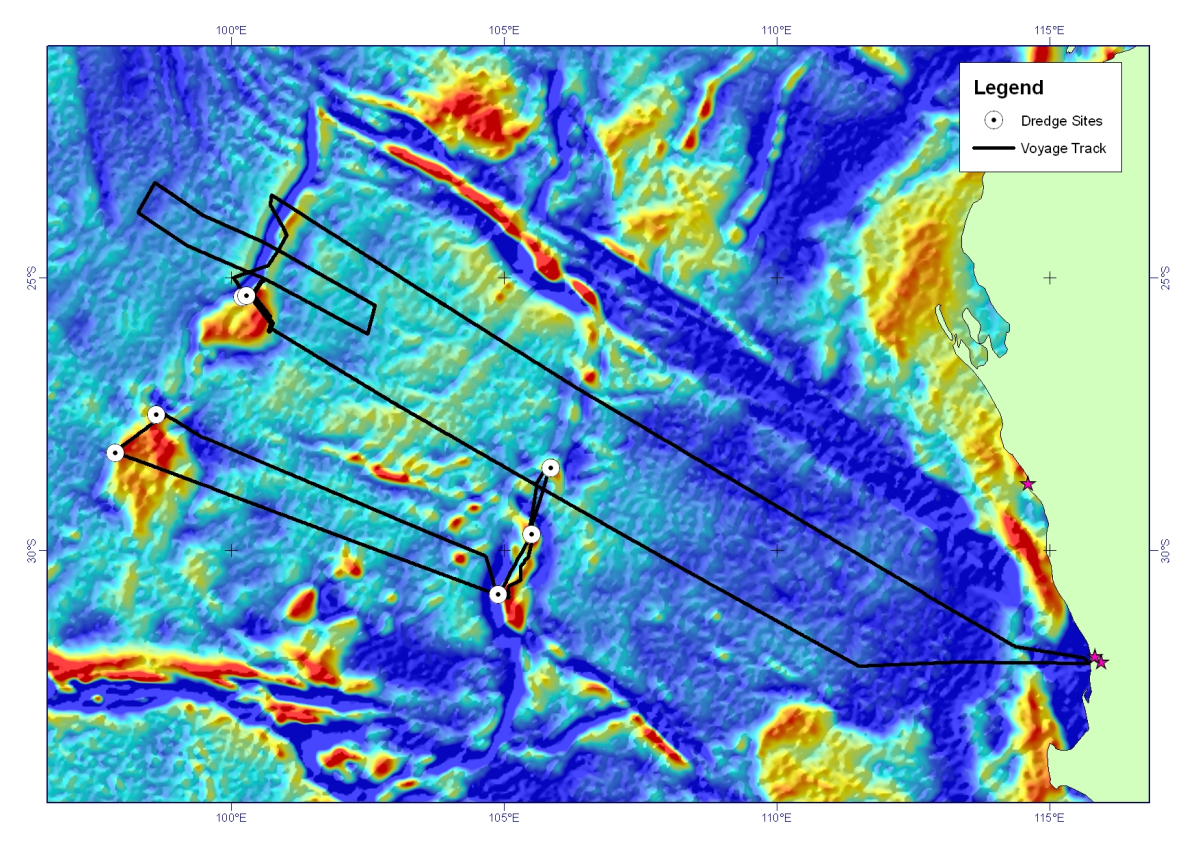
Dredge rocks were recovered on scientific voyage SS2011_06 on the MNF RV Southern Surveyor, from the Perth Abyssal Plain, offshore Western Australia. Continental rocks (gneiss, granite, sandstone) were dredged from both the Batavia Knoll and the Gulden Draak Ridge (dredge sites 1, 2, and 3). A small amount of high weathered basalt was recovered from the Gulden Draak Ridge (dredge site 4). Three successful dredges were undertaken along the Dirck Hartog Ridge recovering predominantly gabbro (dredge 5) and basalts (dredge sites 6 and 7).
-
Rock samples were dredged from seamounts in the southern Tasman Sea on the RV Investigator, voyage IN2018_V08
-
Ocean currents are strongly controlled by seafloor topography. Recent studies have shown that small-scale features with slopes steeper than 0.05° significantly affect subsurface eddy velocities and the vertical structure of ocean circulation patterns. Such slope gradients represent the majority of the present-day oceanic basins. Modeling past oceanographic conditions for key climate stages requires similarly detailed paleo seafloor topography grids, in order to capture ocean currents accurately, especially for ocean models with sufficient resolution (<0.1°) to resolve eddies. However, existing paleobathymetry reconstructions use either a forward modeling approach, resulting in global grids lacking detailed seafloor roughness, or a backward modeling technique based on sediment backstripping, capturing realistic slope gradients, but for a spatially restricted area. Both approaches produce insufficient boundary conditions for high-resolution global paleo models. Here, we compute high-resolution global paleobathymetry grids, with detailed focus on the Southern Ocean, for key Cretaceous and early Cenozoic climate stages. We backstrip sediments from the modern global bathymetry, allowing the preservation of present-day seafloor slope gradients. Sediment isopach data are compiled from existing seismo-stratigraphic interpretations along the Southern Ocean margins, and expanded globally using total sediment thickness information and constant sedimentation rates. We also consider the effect of mantle flow on long-wavelength topography. The resulting grids contain realistic seafloor slope gradients and continental slopes across the continent-ocean transition zones that are similar to present-day observations. Using these detailed paleobathymetry grids for high-resolution global paleo models will help to accurately reconstruct oceanographic conditions of key climate stages and their interaction with the evolving seafloor.
-
Understanding the patterns and characteristics of sedimentary deposits on the conjugate Australian-Antarctic margins is critical to reveal the Cretaceous-Cenozoic tectonic, oceanographic and climatic conditions in the basin. However, unravelling its evolution has remained difficult due to the different seismic stratigraphic interpretations on each margin and sparse drill sites. Here, for the first time, we collate all available seismic reflection profiles on both margins and use newly available offshore drilling data, to develop a consistent seismic stratigraphic framework across the Australian-Antarctic basins. We find sedimentation patterns similar in structure and thickness, prior to the onset of Antarctic glaciation, enabling the basin-wide correlation of four major sedimentary units and their depositional history. We interpret that during the warm and humid Late Cretaceous (~83-65 Ma), large onshore river systems on both Australia and Antarctica resulted in deltaic sediment deposition offshore. We interpret that the onset of clockwise bottom currents during the Early Paleogene (~58-48 Ma) formed prominent sediment drift deposits along both continental rises. We suggest that these currents strengthened and progressed farther east through the Eocene. Coevally, global cooling (<48 Ma) and progressive aridification led to a large-scale decrease in sediment input from both continents. Two major Eocene hiatuses recovered by the IODP site U1356A at the Antarctic continental slope likely formed during this pre-glacial phase of low sedimentation and strong bottom currents. Our results can be used to constrain future paleo-oceanographic modelling of this region and aid understanding of the oceanographic changes accompanying the transition from a greenhouse to icehouse world.