 IMAS Metadata Catalogue
SHARKS/RAYS/CHIMAERAS
Type of resources
Topics
Keywords
Contact for the resource
Provided by
Years
-
This record relates to communications outputs of a research project which centered around working with Indigenous communities to raise the profile of the Largetooth Sawfish and support community driven conservation efforts. Some of the items are intended for public viewing (videos and educational signage); but the other outputs are intended for use by the Indigenous communities involved in the sampling (trip reports and Malak Malak annual floodplain sampling protocol and I-Tracker data collection application).
-
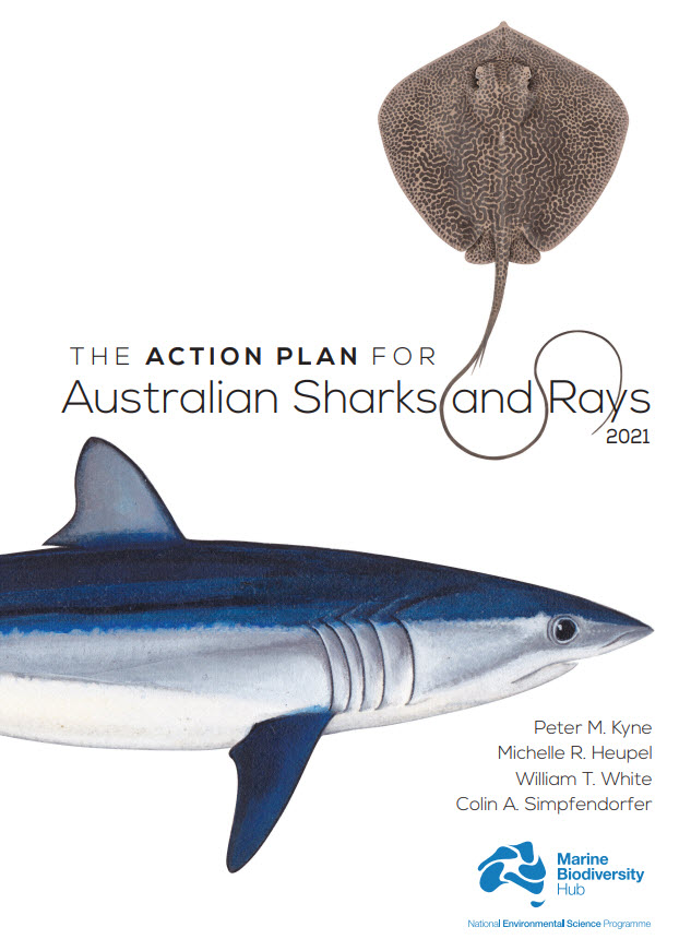
Australia is home to a quarter of the world’s cartilaginous fishes (Class Chondrichthyes) with 328 species consisting of 182 sharks, 132 rays, and 14 chimaeras. Australia’s first Shark Action Plan aims to provide a comprehensive and consistent review of the extinction risk of all cartilaginous fishes (hereafter ‘sharks’) occurring in Australian waters, to provide a benchmark from which changes in population and risk can be measured, and to help guide management for their conservation. This Action Plan also serves to raise the profile of their diversity and conservation needs. This volume includes a taxa profile for each of the 328 species occurring in Australian marine and inland waters, including external territories. Each species’ extinction risk was assessed by applying the IUCN Red List Categories and Criteria at the national level. Assessments of extinction risk consider all available information on a species’ taxonomy, distribution, population status, habitat and ecology, major threats, use and trade, and conservation measures. The IUCN Red List Categories and Criteria utilise a series of thresholds to evaluate extinction risk based on population size reduction, geographic range, population size, or the probability of extinction. Species were assessed against the five Red List criteria; to qualify for one of the three threatened categories (Critically Endangered, Endangered, or Vulnerable), a species had to meet a quantitative threshold for that category in any of the five criteria. The overall status of sharks in Australia is characterised by a relatively low level of extinction risk and a high level of secure species. Of the 328 species, 12% are threatened (39 species: 22 sharks, 17 rays; no chimaeras are threatened); 10% are Near Threatened (32 species: 18 sharks, 13 rays, 1 chimaera); 70% are Least Concern (231 species: 123 sharks, 95 rays, 13 chimaeras); and, 8% are Data Deficient (26 species: 19 sharks, 7 rays, no chimaeras are Data Deficient). No species are Extinct or Extinct in the Wild. Each taxa profile specifies two sets of actions for a species: actions to address knowledge gaps, and actions to maintain, secure, and if necessary, recover the population. To improve the ability to accurately assess the status of species, and ultimately, better conserve and manage them, all species treated in this Action Plan require some knowledge gaps be filled. Knowledge gaps are divided into five themes, each of which improves the information base from which to assess status: taxonomy, distribution, population trend, life history, and connectivity. Conservation actions are provided for each species, regardless of the status assigned them in this Action Plan. While threatened species require immediate action to conserve, manage, and recover their populations, Least Concern species also require action to maintain their secure status. Data Deficient species require action to understand various aspects of their population, but since an assessment as Data Deficient acknowledges the possibility that future research may show that a threatened classification is appropriate, action is also needed to minimise or mitigate threats until such time as more information is available to show that the species is not threatened. Finally, an overarching recommendation is provided for each threatened species. This includes the recommendation that five species be considered for listing on the Environment Protection and Biodiversity Conservation Act (EPBC Act), three species be considered for up-listing, and two species be considered for down-listing. An additional 12 threatened species have been identified as priorities for data collection where further data are required to strengthen the evidence-base underlying their status determinations. These species are priorities for research and monitoring to provide data to support inferred or suspected population reductions or continuing declines identified in the Action Plan. The implementation of the recommendations and actions in this Action Plan will require an ongoing and enhanced investment in science and management which will help secure the future of Australia’s sharks, rays, and chimaeras.
-
This record provides an overview of the NESP Marine and Coastal Hub emerging priorities study - "Application of environmental DNA to survey Bathurst Harbour Tasmania for the endangered Maugean skate". For specific data outputs from this project, please see child records associated with this metadata. -------------------- The Maugean skate (Zearaja maugeana) is listed as Endangered under Tasmania’s Threatened Species Protection Act and the Commonwealth Environmental Protection and Biodiversity Conservation Act 1999. Its known population is small (~3,000 individuals, Macquarie Harbour, 2016) and highly restricted, having only been recorded in two isolated estuaries: Bathurst Harbour and Macquarie Harbour in south-western/western Tasmania. This constitutes one of the most limited distributions of any known extant elasmobranch. Although the skate was first discovered in Bathurst Harbour, most knowledge of the species stems from the Macquarie Harbour population. Only four individuals have been reported in Bathurst Harbour, with the last reported sighting in 1992. Environmental conditions in Macquarie Harbour have changed markedly since then due to anthropogenic activities in and around the estuary including historical mining, hydro-electric generation and alteration of natural river flows, and marine fish farming. Previous research has shown clear signs of population stress and evidence of detrimental impacts of degraded environmental conditions on the Maugean Skate in Macquarie Harbour. Understanding the potential population status of the Maugean Skate in Bathurst Harbour will assist in determining conservation actions. This study used Environmental (e) DNA to determine the presence/absence of Maugean skate in Bathurst Harbour, strengthening the evidence base for effective conservation plans and specific recovery actions. Outputs • Maugean skate eDNA sampling data and inferred species distribution (presence/absence) [dataset] • Final Project Report, including a short summary of recommendations for policy makers of key findings [written]
-
This database contains acoustic telemetry data for euryhaline elasmobranchs in northern Australian rivers. Data was collected under the National Environmental Research Program (NERP) Marine Biodiversity Hub Project 2.4 'Supporting Management of Listed and Rare Species', and the National Environmental Science Program (NESP) Marine Biodiversity Hub Project A1 'Northern Australian Hotspots for the Recovery of Threatened Euryhaline Elasmobranchs'. An acoustic receiver array was deployed in the Adelaide River, and another in the Alligator Rivers (primarily the South Alligator River) to monitor the movements, habitat use and natural mortality of threatened river sharks (Glyphis species) and sawfishes (Pristis species). Receiver deployment data is available through the IMOS Animal Tracking Facility database (visit https://animaltracking.aodn.org.au/receivers/deployment and search for project 'NESP Northern Australian hotspots for the recovery of threatened euryhaline species'). Raw and processed (cleaned) detection data is attached to this record.
-

The Maugean Skate Zearaja maugeana is a micro-endemic species known from only two isolated estuaries, Bathurst and Macquarie Harbours in southwestern/western Tasmania. This constitutes one of the most limited distributions of any known extant elasmobranch. As a result, the species is listed as ‘Endangered’ under the Threatened Species Protection Act (Tasmania) and the Environmental Protection and Biodiversity Conservation Act (Commonwealth). Even though it was first discovered in Bathurst Harbour, most of what is known about the species comes from the Macquarie Harbour population. Only four individuals have ever been reported in Bathurst Harbour, with the last known sighting occurring in 1992. This study used environmental DNA (eDNA) to determine the presence/absence of the Maugean skate in Bathurst Harbour on the southwest coast of Tasmania. Water samples were collected from the seafloor in Bathurst Harbour in November 2021 and February 2022, and in Macquarie Harbour (control samples) in December 2021. Samples were filtered using a self-preserving eDNA sampling system. Following each survey DNA from the samples was extracted and analysed through qPCR amplification. Mitochondrial primer pairs from two gene regions were used to detect the presence of Maugean skate DNA in the samples. Where possible, positive detections were sequenced, and their identity verified.
-
Redmap is a primarily a website that invites the community to spot, log and map marine species that are uncommon in their region, or along particular parts of their coast. The information collected is mapped and displayed on the site, demonstrating, in time, how species distributions may be changing. Sightings are divided into two categories – those with a photo that can be ‘verified’ by a marine biologist, and sightings without photos that we call community sightings (anecdotal). All the information collected, with and without photos, is mapped and will be used in the following years to map out a ‘story’ of changes occurring in our marine environment. The main data collected includes the species sighted (normally selected from a list comprising preselected species of interest), the location, date/time and activity being undertaken. Other optional information gathered include biological data such as sex, size and weight and environmental data such as water depth and temperature and habitat. This record is associated with live data (and will subsequently change over time) and spatial elements have reduced accuracy. It is also subject to a three year embargo (ie. does not contain data less than three years old). If you wish to discuss obtaining a citable, static dataset, that is current and/or contains accurate spatial elements, please see Point of Contact.
-
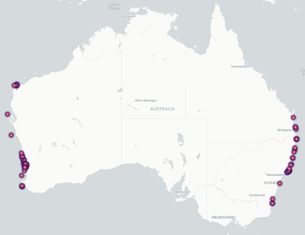
This dataset describes grey nurse shark (Carcharias taurus) listed, recognised and candidate aggregation sites in Australian waters, together with supporting individual acoustic-detection summaries from monitored aggregation sites. It consolidates previously documented site-level information on known, listed and candidate aggregation areas with time-series evidence of acoustically tagged shark detections. The project reviewed existing information on grey nurse shark aggregation sites and developed a revised definition for assessing aggregation status. Under this definition, an aggregation site is a discrete area where multiple grey nurse sharks are observed on a regular or predictable basis and where one or more behavioural functions may be inferred, including migration, resting, reproduction, feeding or undefined aggregation. The project also collected new survey and monitoring evidence from selected areas of potential grey nurse shark use, including Barwon Banks and the Hards in Queensland, Outer Gibber Reef in the Hunter Marine Park, and potential habitat in Gippsland, Victoria. These newly surveyed areas were not classified as confirmed aggregation sites as further monitoring is required to assess whether they support regular or predictable use by multiple grey nurse sharks. The data provided by this record include: • Aggregation-site data: a consolidated table of listed, recognised and potential grey nurse shark aggregation sites and associated information. • Individual detection data: collated acoustic telemetry detection summaries for tagged grey nurse sharks at monitored aggregation sites.
-

This record provides an overview of the NESP Marine and Coastal Hub Research Plan 2023 project "Eastern Grey Nurse Shark population abundance and trend". For specific data outputs from this project, please see child records associated with this metadata. -------------------- Grey nurse sharks are a nationally significant threatened species, with Australia’s eastern population listed as Critically Endangered under the EPBC Act. The Recovery Plan for the Grey Nurse Shark identifies the need for robust estimates of abundance, population trend, age structure, survival and range, particularly where conservation measures such as spatial closures and protection of aggregation sites are in place. This project refined abundance and trend estimates for the eastern Australian grey nurse shark population by combining biopsy sampling, genetic analysis, stereo-video length measurement and statistical modelling. Tissue samples from more than 300 sharks were analysed using close-kin mark-recapture methods to identify family relationships and estimate adult population size. Stereo-video measurements supported improved age estimation using Australian-specific length-at-age models, reducing reliance on overseas growth data. Findings from the project provide a stronger evidence base for Australian and New South Wales government decision-making on grey nurse shark recovery and conservation. Refined estimates of adult abundance and population trend (described in the Final Project Report) enables reduced uncertainty in recovery assessments, and supports evaluation of current management arrangements, including spatial protections for aggregation sites. Outputs • Final project report [written]
-
Redmap is a primarily a website that invites the community to spot, log and map marine species that are uncommon in their region, or along particular parts of their coast. The information collected is mapped and displayed on the site, demonstrating, in time, how species distributions may be changing. Sightings are divided into two categories – those with a photo that can be ‘verified’ by a marine biologist, and sightings without photos that we call community sightings (anecdotal). All the information collected, with and without photos, is mapped and will be used in the following years to map out a ‘story’ of changes occurring in our marine environment. The main data collected includes the species sighted (normally selected from a list comprising preselected species of interest), the location, date/time and activity being undertaken. Other optional information gathered include biological data such as sex, size and weight and environmental data such as water depth and temperature and habitat. This record is associated with live data (and will subsequently change over time) and spatial elements have reduced accuracy. It is also subject to a three year embargo (ie. does not contain data less than three years old). If you wish to discuss obtaining a citable, static dataset, that is current and/or contains accurate spatial elements, please see Point of Contact.
-

This record provides an overview of the NESP Marine and Coastal Hub Research Plan 2024 Emerging Priorities project "Modelling adult abundance and habitat distribution of Maugean skate". For specific data outputs from this project, please see child records associated with this metadata. -------------------- The Maugean skate (Zearaja maugeana) is listed as Endangered under Tasmania’s Threatened Species Protection Act 1995 and the Commonwealth Environment Protection and Biodiversity Conservation Act 1999. The species has one of the most restricted distributions of any extant elasmobranch, having only been recorded in Macquarie Harbour and Bathurst Harbour in western Tasmania. The Macquarie Harbour population is small (~3,000 individuals) and exposed to ongoing environmental pressures, making robust population assessment and habitat monitoring a high conservation priority. This project investigated Close Kin Mark Recapture (CKMR) as a priority method for estimating historical abundance and supporting long-term monitoring of Maugean skate in Macquarie Harbour, as identified in the species’ Roadmap of Agreed Actions and 2023 Conservation Advice. CKMR uses next-generation sequencing to identify close relatives among sampled individuals and model breeding population size, adult survival and population trends. A second project component modelled the distribution of critical Maugean skate habitat in relation to dissolved oxygen, temperature and depth. Telemetry data from tagged skates were combined with biophysical harbour models and habitat selection modelling to generate potential habitat maps for a 2017-18 hindcast period and forecast scenarios based on recent and evolving water-quality conditions. These maps were assessed against existing knowledge of skate habitat to identify critical areas within Macquarie Harbour and inform future spatial and temporal sampling strategies. Project outputs include independent population-assessment methods and hindcast/forecast habitat suitability maps for Macquarie Harbour. These outputs support conservation decision-making, evaluation of remediation scenarios, identification of critical habitat areas, and future monitoring and sampling design. Outputs • High-quality DNA sequences of Maugean skate [sequencing data] • Hindcast maps (2017-18) of potential Maugean skate occupation [spatial data] • Recent and forecast (evolving) maps of potential Maugean skate occupation under different management scenarios [spatial data] • Estimates of spawning stock abundance of the Maugean skate from CKMR analysis [data contained in written report] • Final project report [written]