 IMAS Metadata Catalogue
CONSERVATION
Type of resources
Topics
Keywords
Contact for the resource
Provided by
Years
-
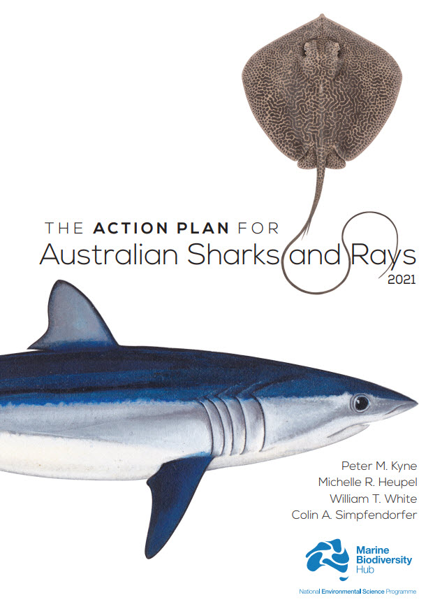
Australia is home to a quarter of the world’s cartilaginous fishes (Class Chondrichthyes) with 328 species consisting of 182 sharks, 132 rays, and 14 chimaeras. Australia’s first Shark Action Plan aims to provide a comprehensive and consistent review of the extinction risk of all cartilaginous fishes (hereafter ‘sharks’) occurring in Australian waters, to provide a benchmark from which changes in population and risk can be measured, and to help guide management for their conservation. This Action Plan also serves to raise the profile of their diversity and conservation needs. This volume includes a taxa profile for each of the 328 species occurring in Australian marine and inland waters, including external territories. Each species’ extinction risk was assessed by applying the IUCN Red List Categories and Criteria at the national level. Assessments of extinction risk consider all available information on a species’ taxonomy, distribution, population status, habitat and ecology, major threats, use and trade, and conservation measures. The IUCN Red List Categories and Criteria utilise a series of thresholds to evaluate extinction risk based on population size reduction, geographic range, population size, or the probability of extinction. Species were assessed against the five Red List criteria; to qualify for one of the three threatened categories (Critically Endangered, Endangered, or Vulnerable), a species had to meet a quantitative threshold for that category in any of the five criteria. The overall status of sharks in Australia is characterised by a relatively low level of extinction risk and a high level of secure species. Of the 328 species, 12% are threatened (39 species: 22 sharks, 17 rays; no chimaeras are threatened); 10% are Near Threatened (32 species: 18 sharks, 13 rays, 1 chimaera); 70% are Least Concern (231 species: 123 sharks, 95 rays, 13 chimaeras); and, 8% are Data Deficient (26 species: 19 sharks, 7 rays, no chimaeras are Data Deficient). No species are Extinct or Extinct in the Wild. Each taxa profile specifies two sets of actions for a species: actions to address knowledge gaps, and actions to maintain, secure, and if necessary, recover the population. To improve the ability to accurately assess the status of species, and ultimately, better conserve and manage them, all species treated in this Action Plan require some knowledge gaps be filled. Knowledge gaps are divided into five themes, each of which improves the information base from which to assess status: taxonomy, distribution, population trend, life history, and connectivity. Conservation actions are provided for each species, regardless of the status assigned them in this Action Plan. While threatened species require immediate action to conserve, manage, and recover their populations, Least Concern species also require action to maintain their secure status. Data Deficient species require action to understand various aspects of their population, but since an assessment as Data Deficient acknowledges the possibility that future research may show that a threatened classification is appropriate, action is also needed to minimise or mitigate threats until such time as more information is available to show that the species is not threatened. Finally, an overarching recommendation is provided for each threatened species. This includes the recommendation that five species be considered for listing on the Environment Protection and Biodiversity Conservation Act (EPBC Act), three species be considered for up-listing, and two species be considered for down-listing. An additional 12 threatened species have been identified as priorities for data collection where further data are required to strengthen the evidence-base underlying their status determinations. These species are priorities for research and monitoring to provide data to support inferred or suspected population reductions or continuing declines identified in the Action Plan. The implementation of the recommendations and actions in this Action Plan will require an ongoing and enhanced investment in science and management which will help secure the future of Australia’s sharks, rays, and chimaeras.
-
Decision-makers seek to account for the socioeconomic values of environmental assets. However, understanding the available frameworks and data can be a barrier. We address this here by summarising the data used across four case studies (3 geographic regions and 3 socio-economic value frameworks) to demonstrate what data are available and how they are applied to support decisions in varied contexts. See 'Lineage' section of this record for additional methodology.
-
This dataset describes grey nurse shark (Carcharias taurus) listed, recognised and candidate aggregation sites in Australian waters, together with supporting individual acoustic-detection summaries from monitored aggregation sites. It consolidates previously documented site-level information on known, listed and candidate aggregation areas with time-series evidence of acoustically tagged shark detections. The project reviewed existing information on grey nurse shark aggregation sites and developed a revised definition for assessing aggregation status. Under this definition, an aggregation site is a discrete area where multiple grey nurse sharks are observed on a regular or predictable basis and where one or more behavioural functions may be inferred, including migration, resting, reproduction, feeding or undefined aggregation. The project also collected new survey and monitoring evidence from selected areas of potential grey nurse shark use, including Barwon Banks and the Hards in Queensland, Outer Gibber Reef in the Hunter Marine Park, and potential habitat in Gippsland, Victoria. These newly surveyed areas were not classified as confirmed aggregation sites as further monitoring is required to assess whether they support regular or predictable use by multiple grey nurse sharks. The data provided by this record include: • Aggregation-site data: a consolidated table of listed, recognised and potential grey nurse shark aggregation sites and associated information. • Individual detection data: collated acoustic telemetry detection summaries for tagged grey nurse sharks at monitored aggregation sites.
-
This record provides an overview of the NESP Marine and Coastal Hub Research Plan 2024 project "Grey Nurse Shark aggregations". For specific data outputs from this project, please see child records associated with this metadata. -------------------- Grey nurse sharks (Carcharias taurus) are protected in Australian Commonwealth waters. Under the EPBC Act, the eastern Australian population is listed as Critically Endangered, while the western Australian population is listed as Vulnerable. The species aggregates at particular sites along migration routes, but existing definitions and criteria for “key aggregation sites” require refinement to support consistent assessment across eastern and western Australia. This project collated existing information on recognised grey nurse shark aggregation sites and potential new sites where sharks have been observed to gather. It reviewed occupancy patterns, existing survey evidence and western population data to refine the definition of a key aggregation site and develop criteria for assessing whether sites should be listed, delisted or prioritised for further investigation. Field and data activities focused on areas where information was limited or where potential new aggregation sites had been identified. These included surveys in Victorian waters near Corner Inlet using ROV and eDNA methods in partnership with Gunaikurnai Land and Waters Aboriginal Corporation; community engagement with dive, fishing and freediving groups to improve reporting of observations; an initial BRUV survey of a reef system in Commonwealth waters in Hunter Marine Park; expanded acoustic receiver coverage at Barwon Banks in Queensland; and review of potential aggregation sites in Western Australia. The project outputs provided Commonwealth and state management agencies with a clearer, more defensible basis for identifying and assessing grey nurse shark aggregation sites. The resulting information supported consistent evaluation of existing and potential sites, prioritisation of future surveys, and improved conservation planning for both eastern and western grey nurse shark populations. Outputs • Spatial information on key Grey Nurse Shark aggregation sites [dataset] • Final project report [written]
-
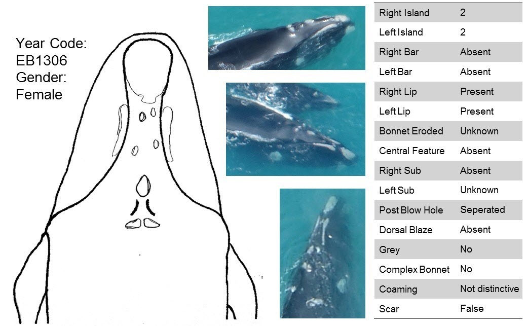
The population of southern right whales in the Southern Hemisphere has been recovering slowly from near extinction due to its decimation from whaling before its ban in 1935 and cessation in the mid-1970’s. As the species recovers, there is increasing evidence of expansion of aggregation areas, including breeding grounds off the coast of Australia. Consequently, there is a need to update known southern right whale established aggregation areas recognised nationally as Biologically Important Areas (BIAs), as well as the national Southern Right Whale Conservation Management and Recovery Plan, which are both used in decision-making using new evidence. This project collated over 2,000 images collected entirely opportunistically by researchers, volunteer citizen scientists, and whale watch operators, and completed matching of individually identifiable whales in photos (i.e., Photo-ID) between 1991 to 2021 in the southwest corner of Australia to evaluate abundance, residency, site fidelity and connectivity in this historically data limited region. The results are reported in the NESP report for Project 1.22 ("A photo-identification study of southern right whales to update aggregation area classification in the southwest of Australia"). A goal of this project was also to upload unique individual southern right whale Photo-IDs into the Australasian Right Whale Photo-Identification Catalogue (ARWPIC; AMMC 2021). The process for these Photo-IDs are briefly described here.
-
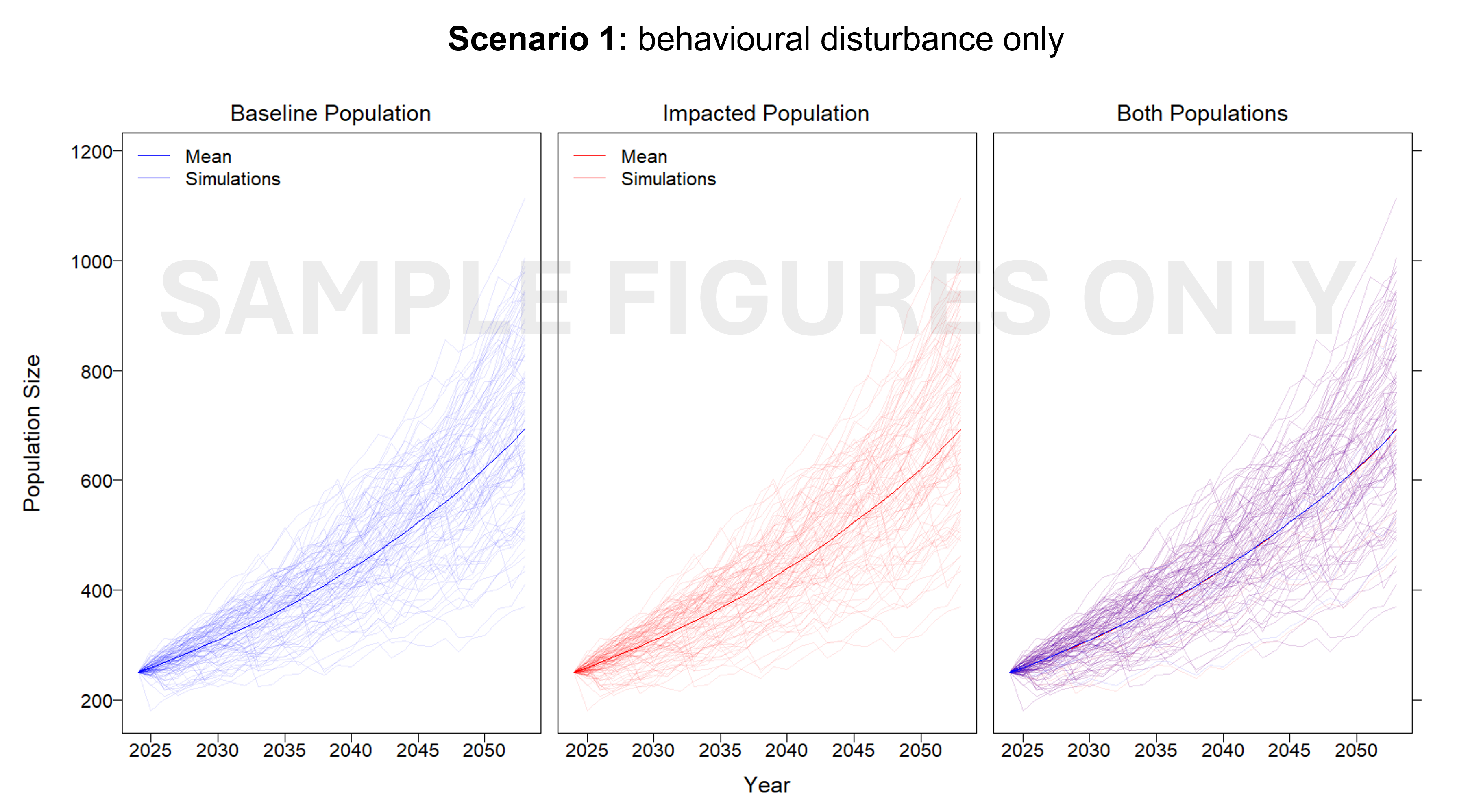
This project developed an interim Population Consequence of Disturbance (iPCoD) model for blue whales (Balaenoptera musculus) and southern right whales (Eubalaena australis) to document a methodology for assessing population-level impacts of one, or multiple, wind farm developments off the southern Australian coast. The iPCoD model was developed in Europe to quantify how disturbances of individuals caused by physiological injury or changes in behaviour can have population-level consequences in data poor marine mammal populations. This model was adapted to suit Australian marine mammal species, highlighting key data gaps for locally threatened populations that overlap in range with the declared offshore wind areas in Australia. Due to the lack of baseline data currently available, this study documented a framework that can be updated as more information becomes available. We outlined how to leverage simulation-based population modelling as a tool for policymakers, industry and management authorities, to aid in environmental impact assessments, with a specific focus on data poor marine mammal populations.
-
Fixed position oxygen and water temperature logger data from the Macquarie Harbour World Heritage Area (WHA). Two Hobo oxygen data loggers are positioned at approximately 15 m depth at different sites within the WHA, with the intent of monitoring representative mid-bottom water oxygen values in the WHA as these were identified in previous studies to be naturally low due to limited seawater exchange at the harbour entrance, and thus likely to be most susceptible to anthropogenic factors that may increase oxygen demand and alter WHA conservation values. These values include core habitat of the Maugean Skate, a listed threatened species. This work is funded by WHA advisory board via the Nature Conservation Branch of DPIPWE and is part of a larger study being conducted by IMAS undertaking a biological baseline study of the biodiversity of the Macquarie Harbour WHA. This data spans 08/11/14 to present (most recent update 02/02/17).