Macquarie Harbour WHA oxygen logger dataset
Fixed position oxygen and water temperature logger data from the Macquarie Harbour World Heritage Area (WHA). Two Hobo oxygen data loggers are positioned at approximately 15 m depth at different sites within the WHA, with the intent of monitoring representative mid-bottom water oxygen values in the WHA as these were identified in previous studies to be naturally low due to limited seawater exchange at the harbour entrance, and thus likely to be most susceptible to anthropogenic factors that may increase oxygen demand and alter WHA conservation values. These values include core habitat of the Maugean Skate, a listed threatened species. This work is funded by WHA advisory board via the Nature Conservation Branch of DPIPWE and is part of a larger study being conducted by IMAS undertaking a biological baseline study of the biodiversity of the Macquarie Harbour WHA.
This data spans 08/11/14 to present (most recent update 02/02/17).
Simple
Identification info
- Date (Creation)
- 2015-07-22
Principal investigator
- Credit
- DPIPWE Nature Conservation Branch
- Status
- On going
Principal investigator
- Temporal resolution
-
P0Y0M1DT0H0M0S
- Topic category
-
- Oceans
Extent
))
Temporal extent
- Time period
- 2014-11-08
Vertical element
- Minimum value
- 14
- Maximum value
- 18
- Identifier
- EPSG::5715
- Name
- MSL depth
- Maintenance and update frequency
- Annually
Resource format
- Title
- Excel spreadsheet (.xlsx)
- Date
- Edition
- 2013
- Keywords (Theme)
-
- Water Quality
- Keywords (Taxon)
-
- Maugean Skate
- Global Change Master Directory (GCMD) Earth Science Keywords Version 8.0
- Keywords (Discipline)
-
- Temperate Reef
- Keywords (Theme)
-
- Concentration of dissolved oxygen (adjusted)
Resource constraints
- Classification
- Unclassified
Resource constraints
- Use limitation
- Note that this data set is uncleaned and includes air and surface values from deployment, retrieval, cap changes etc. Logger data of this nature naturally has occasional spikes and significant outliers should be examined and removed prior to analysis. By using this data you acknowledge that you understand these limitations.
- Use limitation
- The data described in this record are the intellectual property of the University of Tasmania through the Institute for Marine and Antarctic Studies.
Resource constraints
- Linkage
-
http://i.creativecommons.org/l/by/4.0/88x31.png
License Graphic
- Title
- Creative Commons Attribution 4.0 International License
- Website
-
http://creativecommons.org/licenses/by/4.0/
License Text
- Other constraints
- Barrett, NS (2015), Macquarie Harbour WHA oxygen logger dataset. Institute for Marine and Antarctic Studies. Data accessed at http://metadata.imas.utas.edu.au:/geonetwork/srv/en/metadata.show?uuid=20b07936-3bfb-4a72-805d-0b24f1fd4d3f on (access date).
- Other constraints
- Note that this data set is uncleaned and includes air and surface values from deployment, retrieval, cap changes etc. Logger data of this nature naturally has occasional spikes and significant outliers should be examined and removed prior to analysis. By using this data you acknowledge that you understand these limitations.
- Other constraints
- Please contact the researcher when accessing the dataset.
- Language
- English
- Character encoding
- UTF8
- Supplemental Information
- Barrett et al (2015). Macquarie Harbour World Heritage Area Biodiversity Survey 2015 – June Milestone Report
Content Information
- Content type
- Physical measurement
Identifier
- Name
- Temp
- Identifier
- http://vocab.nerc.ac.uk/collection/P06/current/UPAA
- Name
- Degrees Celsius
Identifier
- Name
- DO_conc
- Identifier
- http://vocab.nerc.ac.uk/collection/P06/current/UMGL
- Name
- Milligrams per litre
- Name
- Concentration of dissolved oxygen (adjusted)
- Name
- DO_adj_conc
- Identifier
- http://vocab.nerc.ac.uk/collection/P06/current/UMGL
- Name
- Milligrams per litre
- Description
- Percentage saturation, calculated from relationship with oxygen saturation in water that varies with temperature
Identifier
- Name
- DO_percent_sat
- Identifier
- http://vocab.nerc.ac.uk/collection/P06/current/UPCT
- Name
- Percent
Distribution Information
- Distribution format
-
- Excel spreadsheet (.xlsx)
- OnLine resource
- DATA ACCESS V1 [database format] - Rum Point & Kelly Basin O2 and temperature logging data [direct download]
- OnLine resource
- DATA ACCESS V2 [raw format] - Rum Point & Kelly Basin O2 and temperature logging data [direct download]
- OnLine resource
-
imas:TPW_NSBarrett_MacHarbour_O2_GV_MAP
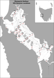
MAP - Locations of O2 logging in Macquarie Harbour
- OnLine resource
-
imas:TPW_NSBarrett_MacHarbour_O2_GV2
This OCG WFS service returns the data for download in subsettable CSV format.
Resource lineage
- Statement
- Hobo oxygen logger data collecting oxygen and temperature data at half hourly intervals. Instrument id the Hobo Dissolved Oxygen Logger U26-001 (http://www.onsetcomp.com/files/manual_pdfs/15603-B-MAN-U26x.pdf). Instrument calibration was conducted prior to deployment, at three months, and at seven months with new cap added at seven months and recalibrated. Data are uncleaned so include pre-deployment air and surface values, surface values at initial retrieval, download and redeployment (3 months), and at seven months redeployment and cap change. Note that logger data of this nature does contain occasional spikes, and that significant outliers would normally be removed prior to any data analysis.
- Hierarchy level
- Dataset
- Hierarchy level
- Dataset
Platform
Identifier
- Code
- fixed benthic node
Metadata
- Metadata identifier
- 20b07936-3bfb-4a72-805d-0b24f1fd4d3f
- Language
- English
- Character encoding
- UTF8
Point of contact
Type of resource
- Resource scope
- Dataset
- Metadata linkage
-
https://metadata.imas.utas.edu.au/geonetwork/srv/eng/catalog.search#/metadata/20b07936-3bfb-4a72-805d-0b24f1fd4d3f
Point of truth URL of this metadata record
- Date info (Creation)
- 2020-08-14T11:57:12
- Date info (Revision)
- 2020-08-14T11:57:12
Metadata standard
- Title
- ISO 19115-3:2018
Overviews


Spatial extent
))
Provided by

 IMAS Metadata Catalogue