 IMAS Metadata Catalogue
Australian iPCoD for measuring baleen whale population consequence of disturbance from offshore energy developments (NESP MaC 4.9)
This project developed an interim Population Consequence of Disturbance (iPCoD) model for blue whales (Balaenoptera musculus) and southern right whales (Eubalaena australis) to document a methodology for assessing population-level impacts of one, or multiple, wind farm developments off the southern Australian coast. The iPCoD model was developed in Europe to quantify how disturbances of individuals caused by physiological injury or changes in behaviour can have population-level consequences in data poor marine mammal populations. This model was adapted to suit Australian marine mammal species, highlighting key data gaps for locally threatened populations that overlap in range with the declared offshore wind areas in Australia. Due to the lack of baseline data currently available, this study documented a framework that can be updated as more information becomes available. We outlined how to leverage simulation-based population modelling as a tool for policymakers, industry and management authorities, to aid in environmental impact assessments, with a specific focus on data poor marine mammal populations.
Simple
Identification info
- Date (Publication)
- 2025-02-16T00:00:00
Identifier
- Title
- Information and documentation - Digital object identifier system
- Citation identifier
- ISO 26324:2012
- Code
- 10.25959/AEKC-B454
- Codespace
- doi.org
- Description
- Digital Object Identifier (DOI)
Principal investigator
Principal investigator
Collaborator
- Credit
- The data collections described in this record are funded by the Australian Government Department of Climate Change, Energy, the Environment and Water (DCCEEW) through the NESP Marine and Coastal Hub. In addition to NESP (DCCEEW) funding, this project is matched by an equivalent amount of in-kind support and co-investment from project partners and collaborators.
- Status
- Completed
Point of contact
Point of contact
- Topic category
-
- Oceans
Extent

Temporal extent
- Time period
- 2024-08-08 2025-02-06
- Maintenance and update frequency
- Not planned
- Keywords (Project)
-
- National Environmental Science Program (NESP) Marine and Coastal Hub
- Keywords (Theme)
-
- population
- demography
- impact assessment
- threatened species
- conservation and management
- offshore renewable energy
- Southern right whale
- Blue whale
- Pygmy blue whale
- Keywords (Taxon)
-
- Balaenoptera musculus
- Eubalaena australis
- Global Change Master Directory Earth Science Keywords, Version 8.5
- AODN Geographic Extents Vocabulary
-
- Coastal Cities / Towns (Australia) | Coastal Cities / Towns (Australia) | Portland, VIC
- Coastal Waters (Australia) | Coastal Waters (Australia) | Victoria Coast, VIC
- Coastal Waters (Australia) | Coastal Waters (Australia) | Tasmania Coast, TAS
- Coastal Waters (Australia) | Coastal Waters (Australia) | New South Wales Coast, NSW
- Coastal Waters (Australia) | Coastal Waters (Australia) | South Australia Coast, SA
- Coastal Waters (Australia) | Coastal Waters (Australia) | West Australia Coast South, WA
Resource constraints
- Classification
- Unclassified
Resource constraints
- Other constraints
- This dataset is hosted by the University of Tasmania, on behalf of The University of Queensland and NESP Marine and Coastal Hub Project 4.9.
Resource constraints
- Linkage
-
https://licensebuttons.net/l/by-nc/4.0/88x31.png
License Graphic
- Title
- Creative Commons Attribution-NonCommercial 4.0 International License
- Alternate title
- CC-BY-NC
- Edition
- 4.0
- Website
-
https://creativecommons.org/licenses/by-nc/4.0/
License Text
- Other constraints
- Cite data as: Volzke, S., Dunlop, R., & Booth, C. (2025). Australian iPCoD for measuring baleen whale population consequence of disturbance from offshore energy developments [Data set]. Institute for Marine and Antarctic Studies. https://doi.org/10.25959/AEKC-B454
Associated resource
- Title
- NESP MaC Project 4.9 - Assessing the vulnerability of southern right whale and blue whale populations to disturbance from windfarm developments, 2024-2025 (UQ)
Identifier
- Association Type
- Dependency
- Initiative Type
- Project
- Language
- English
- Character encoding
- UTF8
Content Information
Distribution Information
- Distribution format
-
- .rdata files and .R code
- OnLine resource
-
DATA ACCESS - browse & download iPCoD model outputs and associated scripts/resources
Data available in both original R format [R-users], and in an extracted (flattened) CSV format [non-R users]
Resource lineage
- Statement
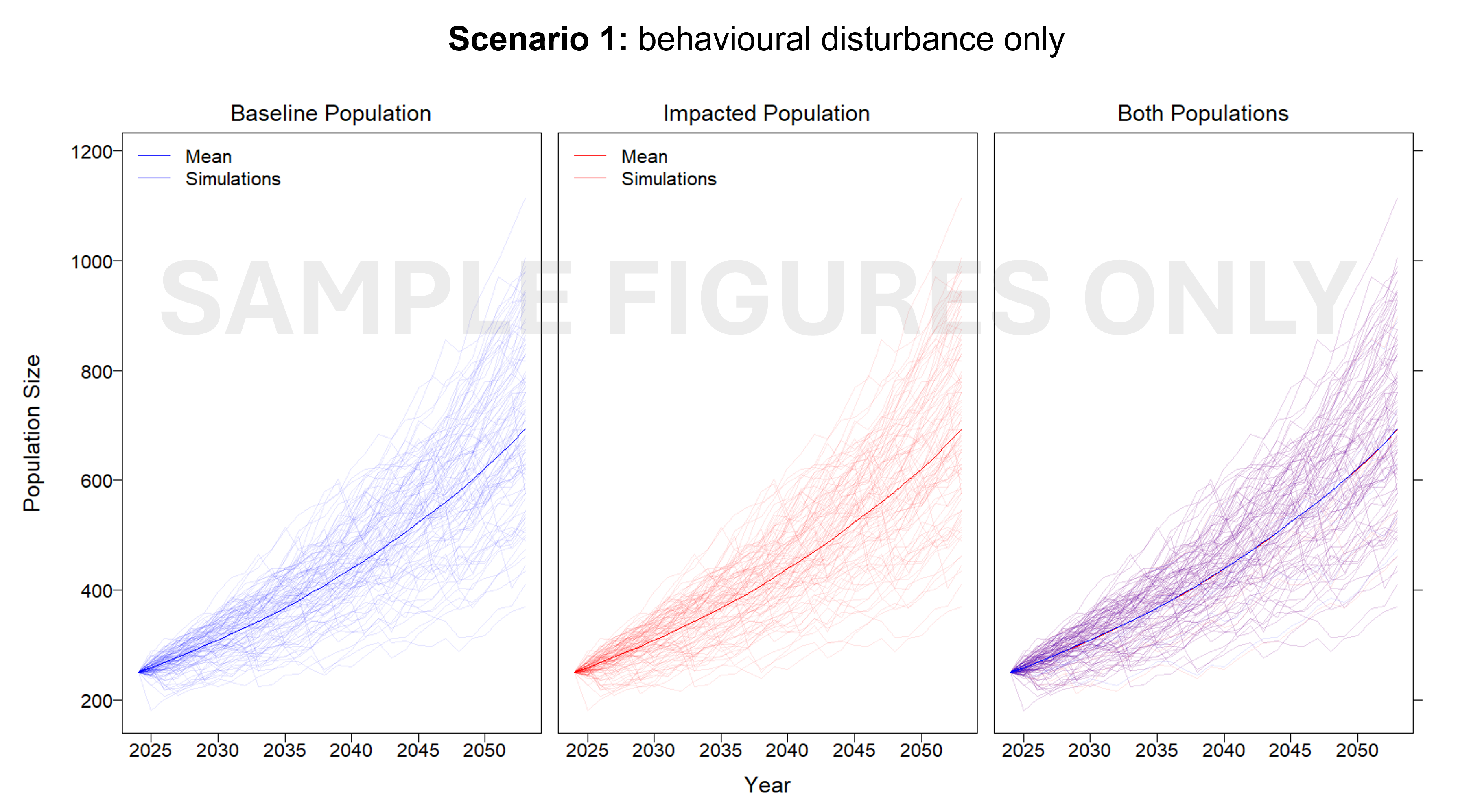
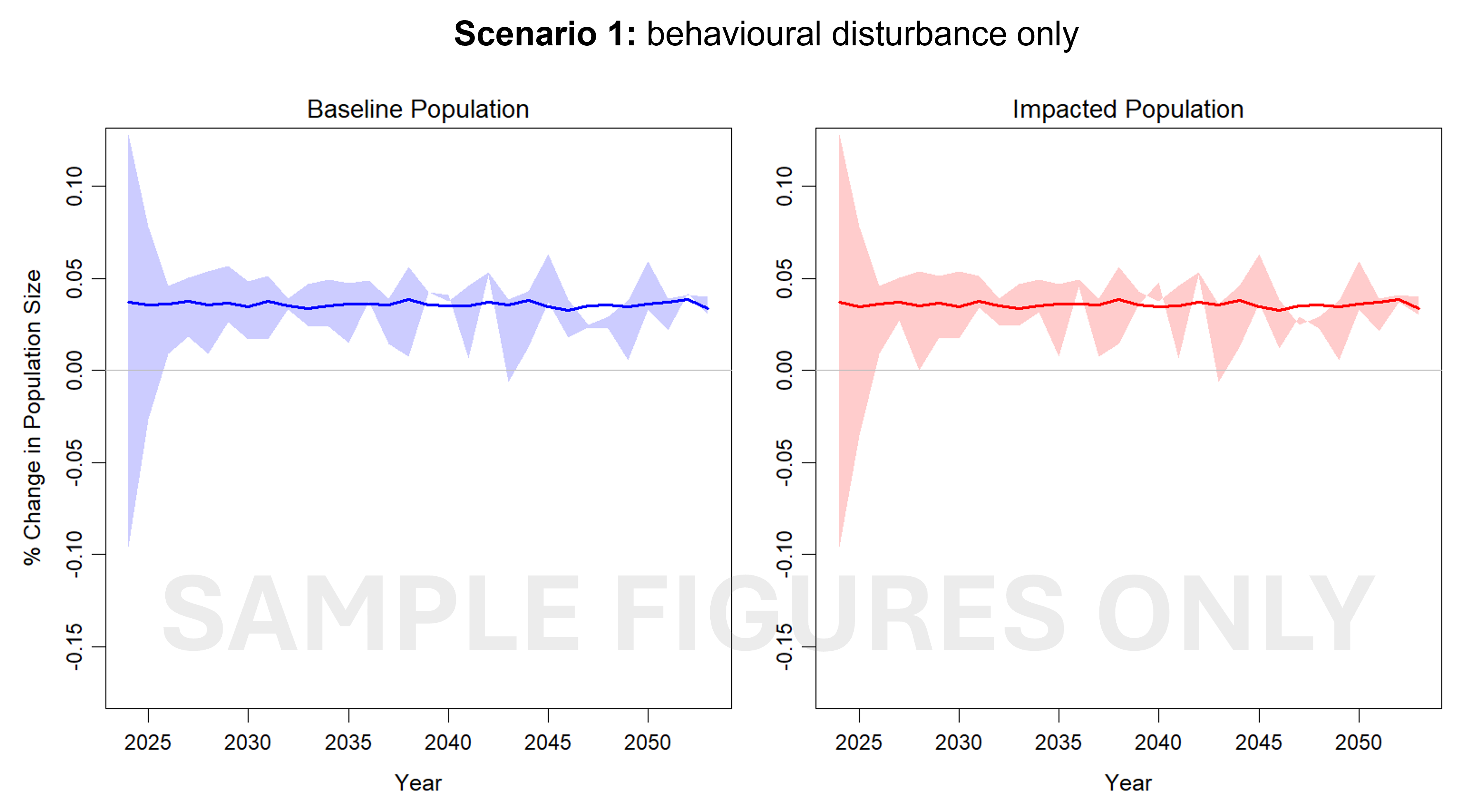
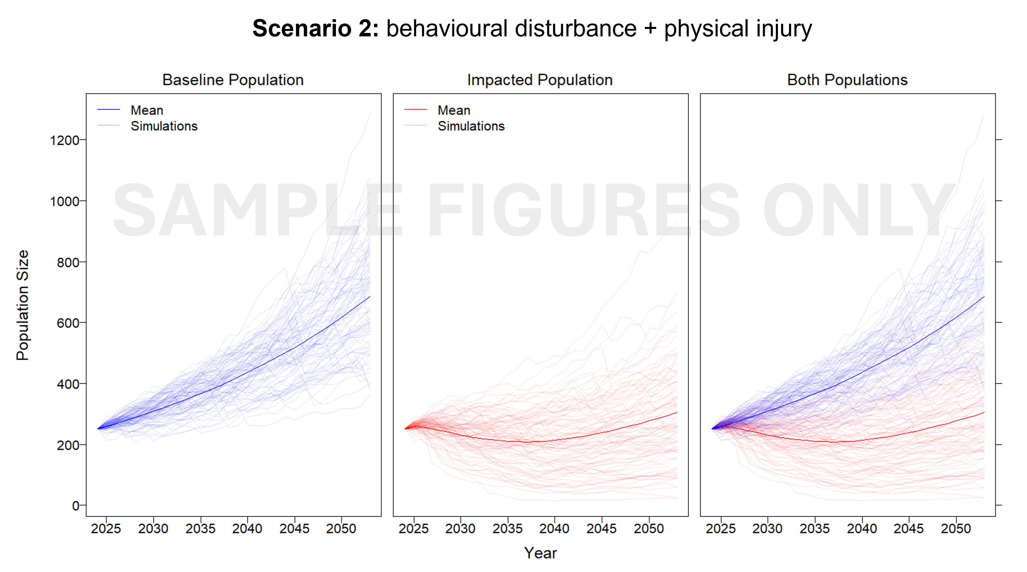
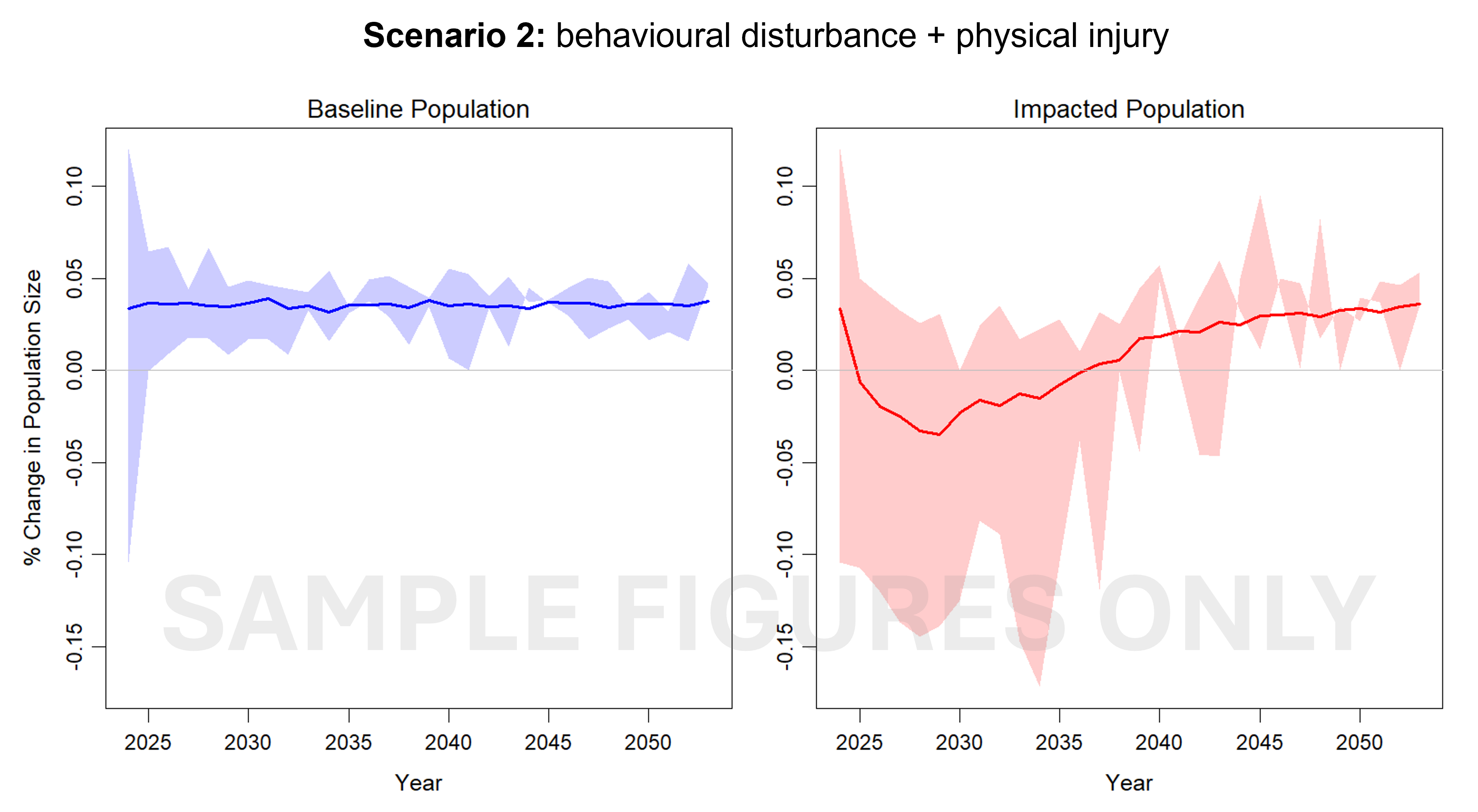
- Publicly available sighting records of blue whales and southern right whales were extracted and used to compute best estimates of the number of individuals at risk of exposure within the spatial extent of the proposed offshore wind farm developments in southeastern Australia. Noise disturbance from pile driving activities was assumed to be the main cause of disturbance from development activities. From this, we generated preliminary radial noise exposure zones used as inputs to the iPCoD model. The iPCoD methodology was adjusted to fit the demography and life history of Australian blue and southern right whales. To demonstrate the potential of this methodology, we simulated two scenarios of disturbance: • Scenario 1: noise from wind farm developments causes behavioural disturbance only. • Scenario 2: noise from wind farm developments cause both behavioural disturbance and physical injury. This approach identified key data gaps and outlines research priorities for collecting more baseline data to improve modelled scenarios of disturbance. A framework of steps was developed that can be used to model disturbance when detailed information becomes available. Simulations were run in R Studio using R version 4.3.3. ---FILE STRUCTURE--- Files: (1) summary_statistics_SV2.R provides code to reproduce graphs and visualise results, supported by (2) SUMMARY_FUNCTIONS_SV.R which includes the functions used in the above file. The above access the following output data files: (3) iPCoD_EE_S1_BW_Output.rdata (4) iPCoD_EE_S1_SRW_Output.rdata (5) iPCoD_EE_S2_BW_Output.rdata (6) iPCoD_EE_S2_SRW_Output.rdata The acronyms used above are as follows: # iPCoD = interim Population Consequence of Disturbance # EE = Expert elicitation # SRW = Southern right whale # BW = Blue whale # S1 = Scenario 1 - behavioural disturbance only # S2 = Scenario 2 - behavioural disturbance + 1 physical injury See ReadMe.txt files contained within the data download package for a full description of the model outputs.
- Hierarchy level
- Dataset
- Hierarchy level
- Dataset
Metadata
- Metadata identifier
- urn:uuid/57edb110-1918-4bd4-9e6f-dc03737baeaf
- Language
- English
- Character encoding
- UTF8
Type of resource
- Resource scope
- Dataset
- Metadata linkage
-
https://metadata.imas.utas.edu.au/geonetwork/srv/eng/catalog.search#/metadata/57edb110-1918-4bd4-9e6f-dc03737baeaf
Point of truth URL of this metadata record
- Date info (Creation)
- 2024-12-20T00:00:00
- Date info (Revision)
- 2026-05-31T11:15:14
Metadata standard
- Title
- ISO 19115-3:2018
Overviews
Spatial extent

Provided by
