 IMAS Metadata Catalogue
2026
Type of resources
Topics
Keywords
Contact for the resource
Provided by
Years
-
This record provides an overview of the NESP Marine and Coastal Hub Emerging Priorities project "A trophic-ecology based tool to assess and manage HAB impacts on marine ecosystems". For specific data outputs from this project, please see child records associated with this metadata. -------------------- South Australia’s 2025 harmful algal bloom (HAB) caused mortality across multiple trophic levels, from primary producers to top predators. This highlighted the need for tools that assess reef ecosystem condition and recovery using food-web structure, not only species counts or biomass estimates. This Emerging Priorities project will develop a trophic integrity framework for assessing subtidal reef condition across South Australia’s marine estate. The framework will support development of a Normalised Reef Status Index (NRSI) based on relative biomass across trophic levels, using biodiversity datasets from Reef Life Survey and the Australian Temperate Reef Collaboration, along with stereo-BRUV surveys and long-term habitat, plankton and water-quality monitoring. The project will model relationships between reef condition and environmental, disturbance and management drivers, enabling assessment of the 2025 HAB and marine heatwave impacts, recovery trajectories, and areas most vulnerable to future events. It will integrate existing and new biodiversity datasets with trophic and spatial analyses to provide a science-based assessment of subtidal reef condition. A web-based decision-support tool will be used to visualise reef condition, disturbance impacts and recovery, and to explore management options such as spatial protection, habitat restoration, fishing closures and rezoning. A technical report with management recommendations will support the SA HAB Science Program, state and Commonwealth agencies, marine park management, and public engagement. Outputs • Quantitative models linking trophic integrity indicators (including the NRSI) with environmental and management drivers [modelling framework] • Spatial prediction and vulnerability maps identifying reef areas most affected by the 2025 HAB and areas most susceptible to future disturbance events [dataset] • Interactive web-based decision-support dashboard for visualising reef condition, disturbance impacts and recovery trajectories, with scenario-testing functionality [tool] • Final technical report [written]
-
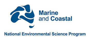
Seagrass beds are a dominant marine ecosystem of Tayaritja (the Furneaux Group of Islands) in the north-eastern waters off Tasmania. Historical coarse mapping has indicated extensive beds of Posidonia, Amphibolis, Heterozostera, and Zostera species, potentially comprising some of the largest and deepest seagrass extents found in temperate Australian waters. However, limited data on the distribution and ecological value of these seagrass habitats represents a significant knowledge gap in understanding Australia's wetland natural assets. This project mapped the extent, ecological composition, population structure, and blue carbon value of seagrass beds around Tayaritja, in partnership with the Tasmanian Aboriginal Centre. This record specifically describes the seagrass population genetics component of the project. Leaf tissue samples were collected from four seagrass species: Amphibolis antarctica, Heterozostera nigricaulis, Posidonia australis and Zostera muelleri. Samples were collected from multiple sites around Tayaritja Sea Country and processed for genome-wide SNP genotyping using the DArTseq platform. The dataset includes population-level genetic summary statistics, associated DArT metadata and reports, and raw sequence data used to support assessment of genetic diversity, clonality, population structure and connectivity among sampled seagrass populations. See the "Lineage" section of this record for full methodology. ***EMBARGO NOTE*** Data is currently embargoed until 31/12/2026. Please contact the NESP Data Wrangler (Southern node) to discuss access options: Emma.Flukes@utas.edu.au
-
This document provides practical guidance on representing persistent identifiers in ISO 19115-3 metadata records for research projects and datasets. It focuses on where and how to record DOI, ROR, ORCID, and RAiD identifiers in ISO metadata, and documents associated community conventions used within the National Environmental Science Program Marine and Coastal (NESP MaC) Hub to support consistency, interoperability, and downstream harvesting. The guide includes encoding guidance, conventions for metadata structure and citation practice, identifier-specific guidance, and XML examples to support implementation in ISO 19115-3 metadata records. Although it is based on workflows used by IMAS and eAtlas within the NESP MaC Hub, the guidance is broadly applicable to other organisations seeking consistent, standards-aligned metadata practices. This guide was developed through the NESP MaC Hub and ARDC co-funded project “Enhancing Discoverability and Impact: Standardising NESP Marine and Coastal Data with Persistent Identifiers" (https://doi.org/10.3565/pkjc-z984) as part of the Domain Data Portals program.
-

This record provides an overview of the NESP Marine and Coastal Hub Emerging Priorities project "National assessment of harmful algal bloom preparedness and future needs". No data outputs are planned for this project. -------------------- The 2025 South Australian harmful algal bloom (HAB) highlighted major gaps in Australia’s preparedness for large-scale marine HAB events, including limitations in surveillance capability, forecasting systems, coordination arrangements and long-term response planning. While HABs are not new to Australia, the scale, duration and ecological impacts of the South Australian event demonstrated the need for a broader national assessment of HAB science capability and policy readiness. This project will review Australia’s current capability for HAB surveillance, forecasting, response and management across environmental and seafood-safety domains. It will examine existing monitoring systems, research capability, early-warning approaches, coordination arrangements and operational policy settings across Commonwealth, state and territory jurisdictions. The review will consider lessons from the South Australian bloom alongside national and international approaches to HAB preparedness and management, including monitoring technologies, forecasting systems and risk mitigation strategies. It will also consider relevant recommendations from the Australian Senate inquiry into the South Australian algal bloom and broader national policy frameworks, including the draft Sustainable Ocean Plan. Project outputs will include an assessment of current national HAB capability, identification of critical knowledge and operational gaps, and recommendations for improving HAB preparedness, surveillance, forecasting, coordination and response capacity in Australia. Outputs • Final technical report [written]
-

This record provides an overview of the NESP Marine and Coastal Hub Emerging Priorities project "Learning from the field: a rapid assessment of the composition and ecotoxicology of the harmful algal bloom in South Australia". For specific data outputs from this project, please see child records associated with this metadata. -------------------- A severe harmful algal bloom (HAB) involving Karenia species has affected large areas of the South Australian coastline, including Gulf St Vincent, Spencer Gulf and Investigator Strait. The species composition, toxicity and ecological impact pathways of the bloom remain poorly understood, limiting the ability of agencies to respond to ongoing and future bloom events. This Emerging Priorities project will conduct a rapid investigation of the composition, toxicity and variability of the South Australian Karenia bloom across sites, depths and bloom stages. Broadscale water sampling will target areas of bloom spread and prolonged exposure, with sampling locations adjusted using satellite chlorophyll maps and field observations. The project will combine microscopy, qPCR-based species identification and abundance estimates, rotifer bioassays, and brevetoxin screening. Rotifer assays will provide a rapid comparative indicator of aquatic toxicity, while qPCR will identify and quantify Karenia species in the same samples, allowing toxicity results to be linked with species composition and bloom development. Selected field samples and cultured strains will also be screened for brevetoxins in collaboration with allied HAB research initiatives. Outputs will include baseline information on bloom toxicity and variability, qPCR-linked species composition data, a rapid rotifer assay method, and a foundational dataset linking Karenia community structure with toxicological response. The findings will support SA DEW, Commonwealth agencies and other research users in understanding bloom impact pathways, improving future HAB response, and informing long-term monitoring and marine environmental management. Outputs • Integrated harmful algal bloom field, water-quality and toxicology dataset across Gulf St Vincent, Spencer Gulf and Investigator Strait [dataset] • Karenia species composition and abundance dataset derived from microscopy and qPCR analyses [dataset] • Toxicity assessment dataset incorporating rotifer bioassays and brevetoxin screening results [dataset] • Final technical report [written]
-
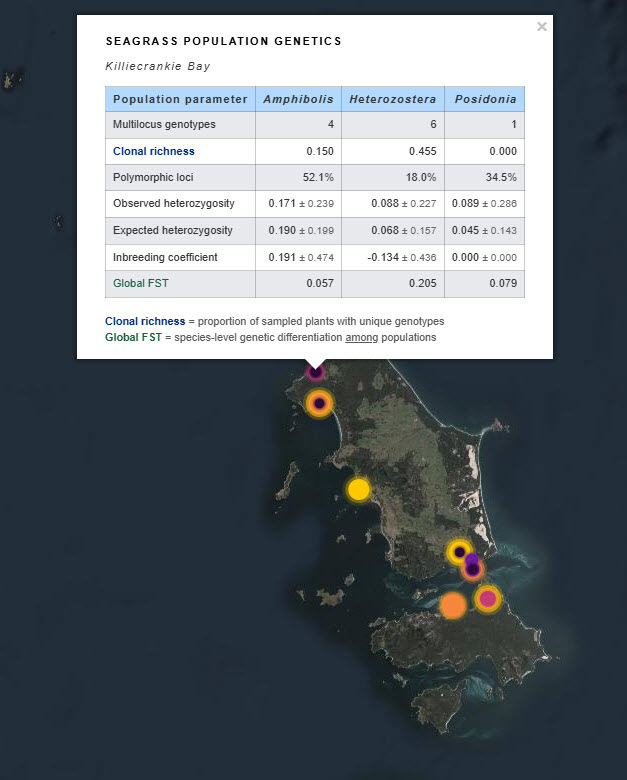
Seagrass beds are a dominant marine ecosystem of Tayaritja (the Furneaux Group of Islands) in the north-eastern waters off Tasmania. Historical coarse mapping has indicated extensive beds of Posidonia, Amphibolis, Heterozostera, and Zostera species, potentially comprising some of the largest and deepest seagrass extents found in temperate Australian waters. However, limited data on the distribution and ecological value of these seagrass habitats represents a significant knowledge gap in understanding Australia's wetland natural assets. This project mapped the extent, ecological composition, population structure, and blue carbon value of seagrass beds around Tayaritja, in partnership with the Tasmanian Aboriginal Centre. This record specifically describes the seagrass-associated blue carbon component of the project, supporting improved understanding of sedimentary carbon storage in the region. Sediment cores were collected from ten seagrass habitat sites around Flinders Island to assess spatial variability in carbon stocks and differences among seagrass species. Cores were collected to a maximum depth of 50 cm, or to the boundary between sediment and underlying rock, and were processed to estimate organic carbon stocks in below-ground sediment and plant material. The dataset includes sampling site locations, carbon stock estimates for the upper 50 cm of sediment, and measurements reported by depth interval within the core. At selected sites, samples were sieved to separate roots/rhizomes from the soil fraction, allowing carbon components to be reported separately where available. See the "Lineage" section of this record for full methodology. ***EMBARGO NOTE*** Data is currently embargoed until 31/12/2026. Please contact the NESP Data Wrangler (Southern node) to discuss access options: Emma.Flukes@utas.edu.au
-

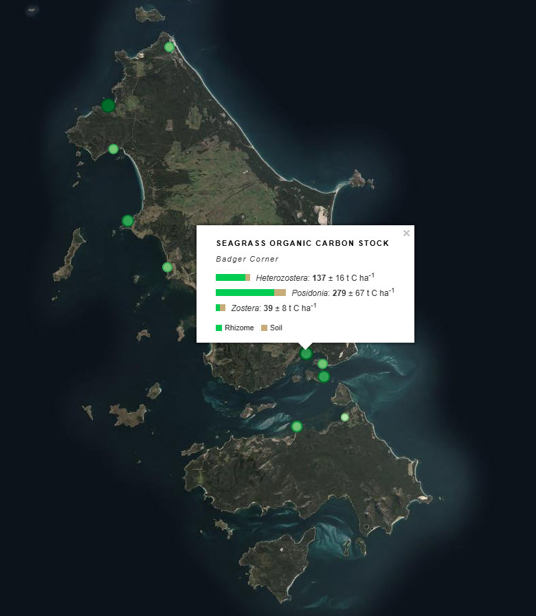
The Parks Australia Management Effectiveness (ME) system - previously MERI - is underpinned by a controlled, common language that provides a nationally consistent lexicon for a) Natural, cultural, and heritage values; (b) Social, cultural, and economic benefits; (c) Activities and anthropogenic pressures; and (d) Biophysical, and social and economic drivers. The Natural Values component of the common language is defined at three levels: 1) ecosystem complexes; 2) ecosystems; and 3) ecosystem components. This map shows the Ecosystems (tier 2) component of the Natural Values, and delineates features by habitat and depth for the Australian Exclusive Economic Zone (EEZ). This version (2026) of the National Values Ecosystems dataset uses Geoscience Australia's 250m resolution AusBathyTopo 2024 grid as the basis for the map. The dataset is currently in draft format and may be updated at any time. The 2026 update incorporates revised and improved input datasets that have become available since the previous release. Several classification rules were updated to align with these inputs, including the use of Seamap Australia National Benthic Habitat Layer data as the primary source for mapped seagrass and coral reef occurrence. Note that this dataset uses a combination of input data sources and interpolates where data gaps exist. The common language adopts a functional, largely geo-physical perspective to define surrogates for marine ecosystems. This dataset is not a substitute for a validated habitat map (see Seamap Australia National Benthic Habitat Layer: https://metadata.imas.utas.edu.au/geonetwork/srv/eng/catalog.search#/metadata/4739e4b0-4dba-4ec5-b658-02c09f27ab9a), but has a national coverage and provides valuable broad-scale categorisation of marine ecosystems in Australian waters. See Hayes et al. 2021 and Dunstan et al. 2023 for a full definition of the Natural Values Ecosystem terms. See the 'lineage' section of this record for full processing notes.
-

This record provides an overview of the NESP Marine and Coastal Hub Emerging Priorities project "Assessing impacts of harmful algal bloom events on South Australian benthic habitats". For specific data outputs from this project, please see child records associated with this metadata. -------------------- In early 2025, South Australia experienced an unprecedented harmful algal bloom (HAB) dominated by Karenia species, with high concentrations in Gulf St Vincent and Spencer Gulf. These gulfs support diverse benthic habitats, iconic biodiversity, and important commercial and recreational fisheries. The rapid development of the bloom and challenges associated with accessing affected areas limited timely assessment of impacts to benthic ecosystem. This Emerging Priorities project will assess HAB impacts by repeating recent benthic surveys at impacted sites across both gulfs. The project will take advantage of existing pre-bloom baseline data, allowing robust before-after comparisons with minimal confounding by seasonal or inter-annual trends. The assessment will integrate towed-camera habitat imagery, stereo-BRUV fish assemblage surveys, benthic trawl data and environmental measurements. Towed-camera resurveys will provide post-bloom imagery, and visual and quantitative assessments of habitat condition. Repeat stereo-BRUV surveys will assess changes in relative abundance, richness and composition of fish and larger invertebrate communities across seagrass and sand habitats. The findings will inform the South Australian HAB Science Program, support development of HAB-related coastal habitat monitoring, and provide evidence for state and Commonwealth agencies to prioritise future monitoring, research and management actions. Outputs • Post-HAB benthic imagery [imagery] • Quantitative assessment of impacts on benthic habitat and fish communities [dataset] • Final technical report [written]
-
The Parks Australia Management Effectiveness (ME) system - previously MERI - is underpinned by a controlled, common language that provides a nationally consistent lexicon for a) Natural, cultural, and heritage values; (b) Social, cultural, and economic benefits; (c) Activities and anthropogenic pressures; and (d) Biophysical, and social and economic drivers. The Natural Values component of the common language is defined at three levels: 1) ecosystem complexes; 2) ecosystems; and 3) ecosystem components. This map shows the Ecosystems (tier 2) component of the Natural Values, and delineates features by habitat and depth for the Australian Exclusive Economic Zone (EEZ). This version (2025) of the National Values Ecosystems dataset uses Geoscience Australia's 250m resolution AusBathyTopo 2024 grid as the basis for the map. The dataset is an interim product between the 2022 version (https://doi.org/10.25959/HEKR-NR42) and an upcoming 2026 revision. The 2025 update incorporates revised and improved input datasets that have become available since the previous release. Several classification rules were updated to align with these inputs, including the use of Seamap Australia National Benthic Habitat Layer data as the primary source for mapped seagrass and coral reef occurrence. Note that this dataset uses a combination of input data sources and interpolates where data gaps exist. The common language adopts a functional, largely geo-physical perspective to define surrogates for marine ecosystems. This dataset is not a substitute for a validated habitat map (see Seamap Australia National Benthic Habitat Layer: https://metadata.imas.utas.edu.au/geonetwork/srv/eng/catalog.search#/metadata/4739e4b0-4dba-4ec5-b658-02c09f27ab9a), but has a national coverage and provides valuable broad-scale categorisation of marine ecosystems in Australian waters. See Hayes et al. 2021 and Dunstan et al. 2023 for a full definition of the Natural Values Ecosystem terms. See the 'lineage' section of this record for full processing notes.
-
The Seamap Australia National Benthic Habitat Layer (NBHL) is a compilation of benthic habitat datasets obtained from various sectors including research, government, industry and community sources, across Australia. These disparate datasets have been integrated into a single national-scale benthic habitat database, and classified uniformly under a national classification scheme implemented as a controlled vocabulary (https://vocabs.ardc.edu.au/viewById/129). Creation of this classification scheme complements work undertaken by the National Environmental Science Program (NESP) Marine Biodiversity Hub (Theme D). For acceptance into the Seamap Australia NBHL, source habitat datasets must meet a set of Acceptance Criteria (documented in https://seamapaustralia.org/wp-content/uploads/2023/01/SeamapAustraliaDataAcceptanceGuidelines.pdf). Broadly speaking, for inclusion in the Seamap Australia NBHL, datasets must: (1) be well-described by metadata or associated documentation; (2) employ a single, consistent classification scheme which avoids non-deterministic or ambiguous terms; (3) be quality-controlled by the provider prior to contribution; (4) beacquired using an established and community-endorsed form of data collection (eg satellite, aerial or acoustic remote sensing); and (5) have documented evidence of ground-truthing validation at the time of data collection (e.g. drop camera, towed video, benthic grabs). The Seamap Australia NBHL can be viewed, analysed and downloaded from the Seamap Australia data portal (https://seamapaustralia.org/map) – a national repository of seafloor habitat data and a decision support tool for marine managers. All habitat datasets in the Seamap Australia data portal, including the NBHL and all local- to regional-scale contributing datasets, are available for download. The Seamap Australia NBHL is a data collection of national importance and highlights the diversity of benthic habitats across Australia’s marine estate. This is the first Australian habitat dataset that seamlessly consolidates data from each of Australia’s state and territory providers. This dataset should be considered a “live” asset and will continue to develop as more suitable validated habitat data becomes available for inclusion, and improvements in data collection and analysis techniques enhance its resolution and currency. The most current (2026) version of the data is available from the following endpoints: WMS: https://geoserver.imas.utas.edu.au/geoserver/seamap/wms WFS: https://geoserver.imas.utas.edu.au/geoserver/seamap/wfs Layer name: SeamapAus_National_Benthic_Habitat_Layer A download link for the full dataset is supplied in the 'Download and Links' section of this record, along with download links to older versions of the dataset. Note that data is now only available in Geodatabase (.gdb) format as it exceeds Shapefile size limits.