 IMAS Metadata Catalogue
Parks Australia's Natural Values Ecosystems 2025 (NESP MaC 4.20)
The Parks Australia Management Effectiveness (ME) system - previously MERI - is underpinned by a controlled, common language that provides a nationally consistent lexicon for a) Natural, cultural, and heritage values; (b) Social, cultural, and economic benefits; (c) Activities and anthropogenic pressures; and (d) Biophysical, and social and economic drivers.
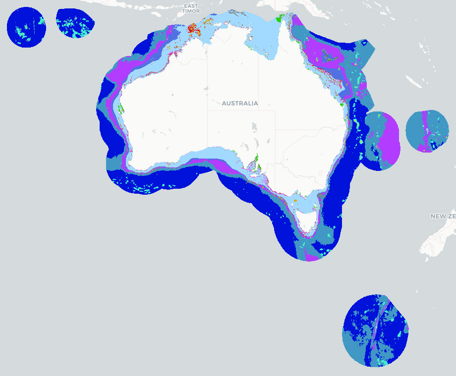
The Natural Values component of the common language is defined at three levels: 1) ecosystem complexes; 2) ecosystems; and 3) ecosystem components. This map shows the Ecosystems (tier 2) component of the Natural Values, and delineates features by habitat and depth for the Australian Exclusive Economic Zone (EEZ).
This version (2025) of the National Values Ecosystems dataset uses Geoscience Australia's 250m resolution AusBathyTopo 2024 grid as the basis for the map. The dataset is an interim product between the 2022 version ( https://doi.org/10.25959/HEKR-NR42) and an upcoming 2026 revision. The 2025 update incorporates revised and improved input datasets that have become available since the previous release. Several classification rules were updated to align with these inputs, including the use of Seamap Australia National Benthic Habitat Layer data as the primary source for mapped seagrass and coral reef occurrence.
Note that this dataset uses a combination of input data sources and interpolates where data gaps exist. The common language adopts a functional, largely geo-physical perspective to define surrogates for marine ecosystems. This dataset is not a substitute for a validated habitat map (see Seamap Australia National Benthic Habitat Layer: https://metadata.imas.utas.edu.au/geonetwork/srv/eng/catalog.search#/metadata/4739e4b0-4dba-4ec5-b658-02c09f27ab9a), but has a national coverage and provides valuable broad-scale categorisation of marine ecosystems in Australian waters.
See Hayes et al. 2021 and Dunstan et al. 2023 for a full definition of the Natural Values Ecosystem terms. See the 'lineage' section of this record for full processing notes.
***An updated version of this data is available, please see https://metadata.imas.utas.edu.au/geonetwork/srv/eng/catalog.search#/metadata/c6ed3079-f030-49e6-8316-a9595ed70f75 ***
Simple
Identification info
- Date (Creation)
- 2026-05-13
- Edition
- Version 0.11
- Edition date
- 2026-01-31T00:00:00
Identifier
- Title
- Information and documentation - Digital object identifier system
- Citation identifier
- ISO 26324:2012
- Code
- 10.25959/7SXA-DX47
- Codespace
- doi.org
- Description
- Digital Object Identifier (DOI)
Principal investigator
Collaborator
- Credit
- The data collections described in this record are funded by the Australian Government Department of Climate Change, Energy, the Environment and Water (DCCEEW) through the NESP Marine and Coastal Hub. In addition to NESP (DCCEEW) funding, this project is matched by an equivalent amount of in-kind support and co-investment from project partners and collaborators.
- Status
- Superseded
Point of contact
- Topic category
-
- Biota
- Environment
- Oceans
Extent

Temporal extent
- Time period
- 2016-01-01
Vertical element
- Minimum value
- 0
- Maximum value
- 7000
- Identifier
- EPSG::5715
- Name
- MSL depth
- Maintenance and update frequency
- As needed
- Keywords (Project)
-
- National Environmental Science Program (NESP) Marine and Coastal Hub
- Keywords (Theme)
-
- research
- monitoring priorities
- Natural Values
- Management Effectiveness (ME)
- MERI
- GCMD Earth Science Keywords
Resource constraints
- Classification
- Unclassified
Resource constraints
- Other constraints
- This dataset is hosted by the Institute for Marine and Antarctic Studies (IMAS), University of Tasmania, on behalf of CSIRO and NESP Marine and Coastal Hub Project 4.20.
Resource constraints
- Linkage
-
http://i.creativecommons.org/l/by/4.0/88x31.png
License Graphic
- Title
- Creative Commons Attribution 4.0 International License
- Website
-
http://creativecommons.org/licenses/by/4.0/
License Text
- Other constraints
- Cite data as: Dunstan, P., Trebilco, R., & Woolley, S. (2026). Parks Australia's Natural Values Ecosystems 2025 [Data set]. Institute for Marine and Antarctic Studies. https://doi.org/10.25959/7SXA-DX47
Associated resource
- Association Type
- Revision Of
- Title
- Parks Australia's Natural Values Ecosystems 2022 (NESP MaC 1.3)
Identifier
- Language
- English
- Character encoding
- UTF8
- Supplemental Information
- Dunstan PK, Woolley SNC, Monk J, Barrett N, Hayes KR, Foster S, Howe SA, Logan D, Samson CR, Francis SO (2023) Designing a targeted monitoring program to support evidence-based management of Australian Marine Parks: National Implementation. Report to the National Environmental Science Program. CSIRO. Hayes, K. R., Dunstan, P., Woolley, S., Barrett, N., Howe, S. A., Samson, C. R., Bowling, R., Ryan, M. P., Foster, S., Monk, J., Peel, D., Hosack, G. R., Francis, S. O. (2021). Designing a Targeted Monitoring Program to Support Evidence Based Management of Australian Marine Parks: A Pilot on the South-East Marine Parks Network. Report to Parks Australia and the National Environmental Science Program, Marine Biodiversity Hub. Parks Australia, University of Tasmanian and CSIRO, Hobart, Australia.
Distribution Information
- Distribution format
-
- Web Map Service, raster, Shapefile
- OnLine resource
-
NESP:MERI_Natural_Values_Ecosystems
Web Map Service (WMS) - Natural Values Ecosystems (2025)
- OnLine resource
-
MERI_Natural_Values_Ecosystems
Download data in GeoTIFF format via WCS
- OnLine resource
- NVCL 2025 Ecosystems processing steps & input data sources
- OnLine resource
-
Associated Report
Dunstan PK, Woolley SNC, Monk J, Barrett N, Hayes KR, Foster S, Howe SA, Logan D, Samson CR, Francis SO (2023) Designing a targeted monitoring program to support evidence-based management of Australian Marine Parks: National Implementation. Report to the National Environmental Science Program. CSIRO.
- OnLine resource
-
Associated Report
Hayes, K. R., Dunstan, P., Woolley, S., Barrett, N., Howe, S. A., Samson, C. R., Bowling, R., Ryan, M. P., Foster, S., Monk, J., Peel, D., Hosack, G. R., Francis, S. O. (2021). Designing a Targeted Monitoring Program to Support Evidence Based Management of Australian Marine Parks: A Pilot on the South-East Marine Parks Network. Report to Parks Australia and the National Environmental Science Program, Marine Biodiversity Hub. Parks Australia, University of Tasmanian and CSIRO, Hobart, Australia.
- OnLine resource
- View map in the interactive Seamap Australia portal
Resource lineage
- Statement
- ---𝐂𝐡𝐚𝐧𝐠𝐞 𝐧𝐨𝐭𝐞𝐬 𝐟𝐨𝐫 𝟐𝟎𝟐𝟓 𝐯𝐞𝐫𝐬𝐢𝐨𝐧--- Coral reef and rocky reef are now differentiated using mapped occurrence rather than a latitude-based decision rule. As a result, rocky reef may now occur adjacent to or surrounding mapped coral reef in tropical areas, for example where live coral reef patches are surrounded by limestone pavement. This change has resulted in substantial differences in mapped coral reef and rocky reef extent compared with the 2022 version. The ecosystem hierarchy has also been revised, including the addition of the "Oceanic vegetated sediment" ecosystem, consistent with recommendations from NESP Marine and Coastal Hub Project 2.3 (https://www.nespmarinecoastal.edu.au/project/2-3) ---𝐂𝐨𝐫𝐚𝐥 𝐫𝐞𝐞𝐟 𝐚𝐧𝐝 𝐬𝐞𝐚𝐠𝐫𝐚𝐬𝐬-𝐬𝐩𝐞𝐜𝐢𝐟𝐢𝐜 𝐠𝐮𝐢𝐝𝐚𝐧𝐜𝐞--- The classification uses the unvalidated National Benthic Habitat Layer because it consolidates several previously used datasets and includes additional targeted acoustic survey information. Users should note that the updated shelf vegetated sediment class, derived from the Seamap national benthic habitat map, excludes seagrass occurring on hard substrate. For applications requiring seagrass extent specifically, direct extraction from the Seamap Australia National Benthic Habitat Layer may be more appropriate than using the NVCL "Shelf vegetated sediment" class as a proxy. Additional consideration may be required for seagrass and for coral reef below visual detection depths in northern Australia. ---𝐆𝐞𝐧𝐞𝐫𝐚𝐥 𝐌𝐞𝐭𝐡𝐨𝐝𝐨𝐥𝐨𝐠𝐲--- Ecosystems were defined via a combination of depth and characteristic habitat, using Geoscience Australia's 250m resolution AusBathyTopo 2024 grid (https://doi.org/10.26186/150050). From this, depth-labelled cells were used to geo-locate the depth boundaries between different ecosystems. The map was created using a series of sequential applications of the Management Effectiveness common language definitions (see Hayes et al. 2021). For example, all cells in the depth rage 0-200m were initially identified as "shelf unvegetated sediments", and all cells in the depth range 200-700m assigned as "upper slope unvegetated sediments", and so forth. Reef, coral and vegetated ecosystems are then added to, and excised from, these regions. In this manner, ecosystem map layers were created for all the Common Language Ecosystems with the exclusion of beaches, intertidal coral reefs, and rocky shores. ---𝐏𝐫𝐨𝐜𝐞𝐬𝐬𝐢𝐧𝐠 𝐒𝐭𝐞𝐩𝐬--- See PDF attached to this record for a full list of data inputs and description of the process steps used to generate the 2025 NVCL Ecosystems product.
- Hierarchy level
- Dataset
Metadata
- Metadata identifier
- urn:uuid/c1612406-a807-4073-a776-8d58af19b139
- Language
- English
- Character encoding
- UTF8
Point of contact
- Parent metadata
Type of resource
- Resource scope
- Dataset
- Metadata linkage
-
https://metadata.imas.utas.edu.au/geonetwork/srv/eng/catalog.search#/metadata/c1612406-a807-4073-a776-8d58af19b139
Point of truth URL of this metadata record
- Date info (Revision)
- 2026-10-15T13:38:15
- Date info (Creation)
- 2026-05-14
Metadata standard
- Title
- ISO 19115-3:2018
Overviews
Spatial extent

Provided by
