 IMAS Metadata Catalogue
Oceans Institute
Type of resources
Topics
Keywords
Contact for the resource
Provided by
Years
-
This record provides an overview of the NESP Marine and Coastal Hub bridging study - "Characterising natural values and identifying indicators and metrics in South-west Corner Marine Park". For specific data outputs from this project, please see child records associated with this metadata. -------------------- Inventory surveys of Australian Marine Parks (AMPs) provide a broad description of the natural assets that exist in Commonwealth waters. These data can be further explored to identify biological indicators and metrics to cost-effectively monitor the AMPs and inform the AMP Monitoring Evaluation Reporting and Improvement (MERI) system. Historical surveys conducted under the NESP Marine Biodiversity Hub inventoried natural values and ecosystem components in selected AMPs. They developed and tested standardised survey techniques to allows scientists and park managers to identify and measure the status of natural values and ecosystem components. A recent Marine Biodiversity Hub survey conducted detailed bathymetric and visual sampling of key seafloor habitat and fish assemblages in the Capes region of South-west Corner Marine Park (Western Australia). This project analysed the Capes survey data to characterise and predict the broader distribution of natural values and ecosystem features, and to identify relevant indicators of fish and benthic assemblages for Park management. The results are presented alongside summaries of existing knowledge on natural, socio-economic, and cultural values, as well as human pressures. Recommendations include establishing national and international monitoring benchmarks and incorporating survey guidance from Traditional Owners. Outputs • Habitat annotations for AUV & drop camera imagery [dataset] • Habitat map using existing fine-scale bathymetry coverage (validated by drop camera surveys) [dataset] • Annotations of fish and shark size, abundance and diversity from stereo-BRUV deployments [dataset] • Science communication article for the Australian Marine Parks Science Atlas [written] • South-west Corner Marine Park survey report [written]
-
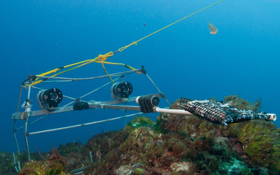
Benthic habitat annotations of stereo Baited Remote Underwater Video (Stereo-BRUV) and panoramic drop camera imagery, were completed as part of a report funded by the NESP Marine & Coastal Hub. This report focussed on an IUCN II zone in the South-west Corner Marine Park off the 'Capes region' near Margaret River. These data were analysed in TransectMeasure using a modified version of the CATAMI scheme.
-
Fish annotations of stereo Baited Remote Underwater Video and panoramic drop camera imagery, were completed as part of a report funded by the NESP Marine & Coastal Hub. This report focussed on an IUCN II zone in the South-west Corner Marine Park off the 'Capes region' near Margaret River. These data were analysed in EventMeasure using standard operating procedures for the annotation of remote stereo imagery.
-

This record provides an overview of the NESP Marine and Coastal Hub project "Improving socio-ecological understanding of natural values in Australian Marine Parks". No public data outputs will be generated by this project. -------------------- Parks Australia (Australian Government) manage 60 Australian Marine Parks (AMPs) around the country, covering an area of 3.8 million square kilometres, or 43% of all Australian waters. The approach to managing AMPs is set out in eight Management Plans: one for each of the five marine park networks (North, North-west, South-west, South-east and Temperate East) and one each for the Coral Sea Marine Park, Christmas Island Marine Park and Cocos (Keeling) Islands Marine Park. A statutory review of Management Plans for the North, North-west, South-west, Temperate-East networks and the Coral Sea Marine Park is scheduled for 2028. Socio-economic information is needed alongside natural values data to assess management effectiveness and understand how Australians use, value and perceive the marine park system. This project progressed the use of socio-economic information to support Australian Marine Park management and the 2028 management plan review. It builds on previous NESP research by redeveloping socio-economic benchmarks aligned with Parks Australia’s sentinel park approach and network-scale reporting, and complements NESP-led data synthesis projects (SS2, D7, 1.3, 4.20 and 4.21). The project redesigned two repeatable national surveys: a knowledge, attitudes and practice boat ramp survey targeting recreational fishers and non-fishers who use Australian Marine Parks, and a general public survey exploring broader community awareness, attitudes and views on management zones. Nine boat-ramp survey locations were selected with Parks Australia to support park- and network-scale estimates of recreational use covering the Coral Sea, and North, North-west, South-west, South-east and Temperate East networks. The survey design and sampling regime provide a basis for assessing changes in awareness, attitudes and use patterns since the 2019/20 benchmark. Combined with natural values data, these outputs strengthen the Management Effectiveness system and support more integrated reporting on the social, economic and ecological values of Australian Marine Parks. Outputs • Responses from recreational user surveys [dataset]. In accordance with National Statement on Ethical Conduct in Human Research, only aggregated outputs will be made publicly available. • Final technical report [written]
-
Predictions of dominant habitats were completed as part of a report funded by the NESP Marine & Coastal Hub. This report focussed on an IUCN II zone in the South-west Corner Marine Park off the 'Capes region' near Margaret River. This modelling contains data from stereo Baited Remote Underwater Video and panoramic drop camera, and was completed using the FSS-GAM package in R. Predictions are at two different scales and resolutions, one using the broad 250 metre resolution Geoscience Australia 2009 bathymetry grid (http://dx.doi.org/10.4225/25/53D99B6581B9A) and the other using a 5 metre resolution Geoscience Australia multibeam survey (https://dx.doi.org/10.26186/145281).
-

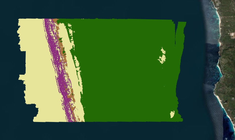
This record describes the outputs of two different modelling exercises that were used to characterise the seafloor habitats for temperate Australian waters. The modelled area includes all shelf waters (<250m depth) in southern Australia south of the Tropic of Capricorn. Bioregional benthic habitat maps were constructed using (1) the Geoscience Australia 250m 2023 grid (Beaman 2023); (2) ground-truthing observations derived from horizontally facing imagery from stereo-BRUV and BOSS camera systems; and (3) several physical datasets as covariates in model development (all oceanographic variables smoothed to 250m resolution). Source data is available from Geoscience Australia's eCat: https://doi.org/10.26186/148758 (bathymetry), Squidle+: (benthic imagery annotations), and (3) AODN Portal: https://portal.aodn.org.au/search (IMOS oceanographic datasets). The specific subset of benthic observations used in this modelling exercise is available from https://github.com/UWA-Marine-Ecology-Group-projects/nesp-2.1/blob/main/data/tidy/NESP-2.1_broad-habitat.csv. See the NESP Mac Project 2.1 final report for a description of the sampling design for ground-truthing observations and annotation technique. -----Functional Reef model (binomial)----- This model discriminates ‘functional reef’ from sediment (non-reef) ecosystem types. Functional reef is defined by this project as “any seabed area functioning as a reef, which may include dense beds of sessile invertebrates or molluscs”. This term was chosen because much of the continental shelf is dominated by sediment yet is stable enough to support emergent sessile biota that provide structure and resources for “reef-affiliated” species. The modelling approach uses a Bayesian representation of a Binomial generalised linear model. For ground-truthing benthic annotations, the following benthic categories were collapsed into the ‘functional reef’ classification: sessile invertebrates, bare rocky reef (consolidated), macroalgae, Amphibolis spp. and Thalassodendron spp. All other benthic classifications were assigned to the ‘non-reef’ category. -----Ecosystem Component model (multinomial)----- This model discriminates between five broad habitat types (hereafter ‘ecosystem components’): seagrass, macroalgae, sessile invertebrates, bare consolidated substrata, bare unconsolidated substrata. The modelling approach uses a Bayesian implementation of a Multinomial generalised linear model. For ground-truthing benthic annotations, benthic annotations for mobile species (e.g. echinodermata) were discarded. All remaining annotations were collapsed into the five broad ecosystem components. A selection of mapping (WMS) services are listed in the 'Downloads & Links' section of this record. See the 'Lineage' section for a full description of the data packages available for download, and for more visualisation options.
-
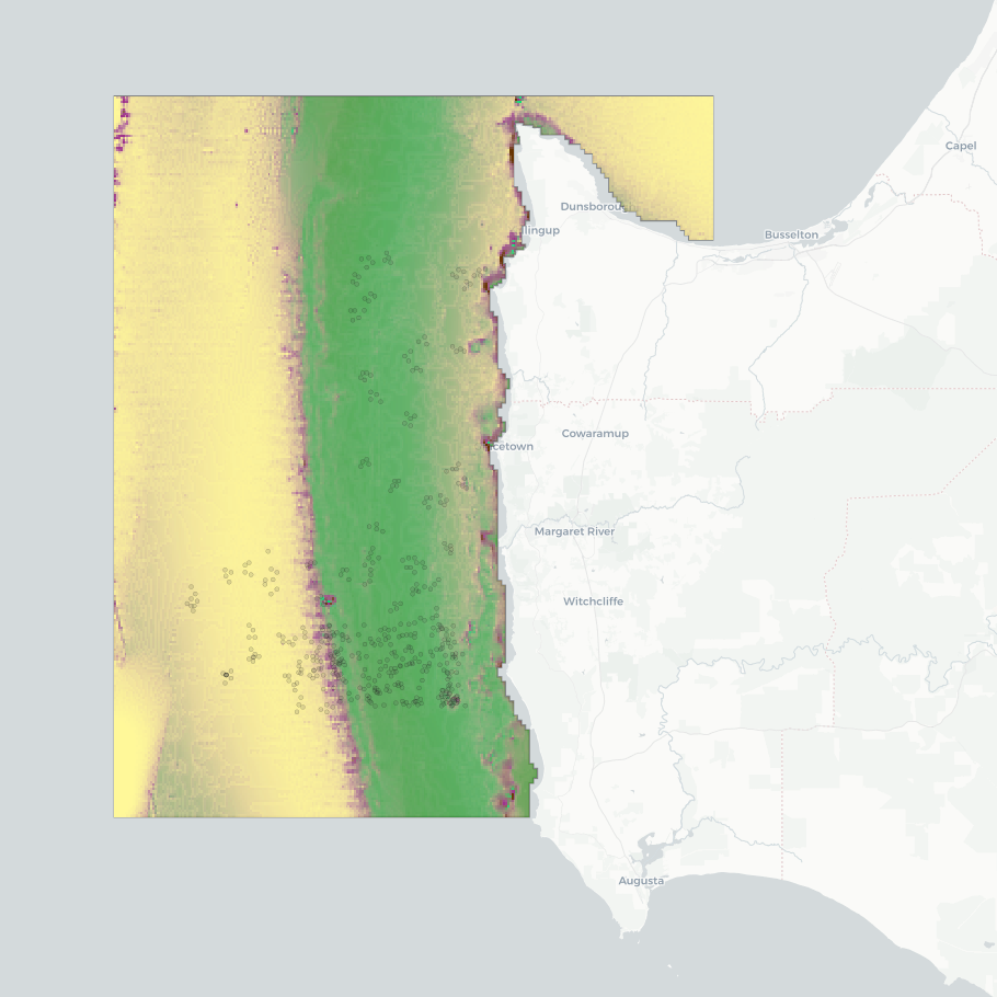
This dataset presents the results of a seafloor habitat modeling exercise for the 'Capes region' of the South-west Corner Marine Park, southern WA. The model classifies five broad habitat types (hereafter 'ecosystem components'): seagrass, macroalgae, sessile invertebrates, bare consolidated substrata, and bare unconsolidated substrata. Modeling was conducted at two spatial scales to assess the effectiveness of using broad-scale (~250 m) spatial covariates derived from bathymetry in mapping habitat classes and to compare the modelling outcomes with those obtained using finer-resolution input data. The fine-scale mapping focused on an IUCN II zone near Margaret River, using a seamless 5 m resolution multibeam bathymetry composite. The broad-scale mapping covered multiple IUCN zones, including the southwestern Geographe Australian Marine Park (AMP), the northwestern tip of the South-west Corner AMP, and the Ngari Capes WA State Marine Park. This component used the 250 m resolution 2023 AusBathyTopo grid from Geoscience Australia. Habitat maps were constructed using (1) the bathymetry data sources described above; (2) ground-truthing observations from stereo-BRUV and BOSS camera systems; and (3) Physical covariates, all smoothed to 5 m or 250 m resolution, for the fine- and broad-scale mapping, respectively. Source datasets are available from: • Geoscience Australia's eCat: https://dx.doi.org/10.26186/145281 (5 m multibeam bathymetry) and https://doi.org/10.26186/148758 (250 m DEM bathymetry) • Squidle+: http://squidle.org/geodata/explore (benthic imagery annotations - see also outputs from NESP MaC Project 2.4: https://doi.org/10.25959/6G5A-3G03) • AODN Portal: https://portal.aodn.org.au/search (IMOS oceanographic datasets). This analysis uses the modelling methodology developed in NESP Project 2.1, which extended the ecosystem component modelling to include all temperate Australian shelf waters at a resolution of 250 m (https://doi.org/10.25959/BVJ7-D984). Analysing the scale effects effects of spatial covarariate inputs was undertaken by NESP Project 2.3, along with exploration of visualisation options regarding prediction certainty in consultation with Parks Australia (management end-users). Further details on sampling design for ground-truthing observations and the modelling techniques are available in the NESP MaC Project 2.1 Final Report: https://www.nespmarinecoastal.edu.au/publication/improving-seabed-habitat-predictions-for-southern-australia. A description on this specific South-west Corner case study and the spatial scale analysis is described in the NESP MaC Project 2.3 Final Report: https://www.nespmarinecoastal.edu.au/publication/improving-knowledge-transfer-to-support-australian-marine-park-decision-making-and-management-effectiveness-evaluation. A selection of mapping (WMS) services are listed in the 'Downloads & Links' section of this record. See the 'Lineage' section for a full description of the data packages available for download, and for more visualisation options.