 IMAS Metadata Catalogue
New South Wales Department of Primary Industries
Type of resources
Topics
Keywords
Contact for the resource
Provided by
Years
-
This record provides an overview of the NESP Marine and Coastal Hub Research Plan 2023 project "Assessing changes in black rockcod abundance and size". For specific data outputs from this project, please see child records associated with this metadata. -------------------- The black rockcod (Epinephelus daemelii) is a long-lived, reef-dwelling species listed as Vulnerable under Commonwealth and NSW legislation. In Australia it occurs along the coast of New South Wales, including at Lord Howe Island. Although protected from fishing in NSW since 1983, the species is vulnerable to illegal take, incidental capture, barotrauma-related mortality, and degradation of nursery habitats. Long-term monitoring is a high priority for assessing whether recovery actions and spatial protections are improving population status. This project repeated the broadscale baseline survey of black rockcod across northern NSW and Lord Howe Island, extending a monitoring program that began in 2009–2011 and included smaller key-site surveys every four to five years. Divers surveyed reef sites, photographed and filmed individual fish, recorded habitat and depth, and estimated fish lengths, including with stereo-video where possible. Additional local field capability was built through Indigenous engagement and community-based monitoring activities. These survey outputs contributed to a 15-year time series (2009-2024) on abundance, occupancy, size structure, habitat associations, and spatial distribution of black rockcod. The results indicated continued low abundance across the species’ surveyed range, while also identifying larger mature individuals and higher abundances in some no-take sanctuary zones. The long-term dataset provided evidence for assessing recovery actions and sanctuary zone effectiveness, informs future monitoring priorities, and supports potential reassessment of the species’ threatened status. Outputs • Black rockcod underwater visual census (UVC) data [dataset] • Final project report [written]
-
The Black Rockcod (Epinephelus daemelii) is a large, slow-growing, long-lived reef fish that occurs in Australia along the coast of New South Wales, including at Lord Howe Island. Populations of black rockcod have been significantly reduced here due to overfishing, accidental hooking, and loss or degradation of estuarine and intertidal nursery habitats. As a result, the species is listed as ‘Vulnerable’ under both the Commonwealth Environmental Protection and Biodiversity Conservation Act 1999 and the NSW Fisheries Management Act 1994. Despite having been protected from fishing in NSW since 1983, black rockcod are still taken illegally, or caught incidentally and released, which can lead to mortality post-release from embolism. Its protection status results from concerns of population declines across its range. The NSW Government has identified long-term population monitoring as a a high priority for the species’ recovery plan. Broadscale surveys of black rockcod were first conducted using the diver Underwater Visual Census (UVC) technique in 2009-11 when 83 sites were sampled from Port Stephens to Cook Island in far northern NSW, including the waters of Lord Howe Island. This NESP Marine and Coastal Hub project 3.14 funded the repeat of these broadscale surveys in 2023, with 8 additional sites (91 total) sampled using the same technique. For each black rockcod sighting, the length of the fish was visually estimated by divers, and also filmed using a diver stereo camera system where possible to obtain an exact length measurement. Other attributes recorded included the habitat the fish was found in, if the sighting was cryptic (i.e. hidden or camouflaged), and the depth of the sighting. Based on the broadscale survey sites in 2009-11, a subset of 19 key Black rockcod survey sites along mainland NSW were established These comprised of two sites in the Cape Byron Marine Park (CBMP), five sites in the Solitary Islands Marine Park (SIMP) two sites at SW Rocks (Fish Rock), and ten sites within the Port Stephens-Great Lakes Marine Park (PSGLMP). An additional 18 key sites were established at Lord Howe Island (LHIMP) and surveyed in 2011, 2019, 2023 & 2024. These surveys involved an identical methodology to the broadscale surveys, but without the use of stereo cameras as diver estimates of fish size were shown to be reasonably similar. This NESP MaC Hub project 3.14 provided funding for the resurveying of the 37 total key sites (where weather permitted) in both 2023 and 2024. The data provided by this record includes: (1) all black rockcod sightings and measurements for broadscale sites (2023) and key sites (2023 & 2024); (2) a comparison of the counts of black rockcod recorded at broadscale sites in 2009-11 (n=83) and again in 2023 (n=91); and (3) a comparison of the count of black rockcod recorded at key monitoring sites in northern NSW (n=19) and Lord Howe Island (n=18) across monitoring years 2009-2024.
-
This record provides an overview of the NESP Marine and Coastal Hub project "Advancing national standards and best practices to monitor key marine values and pressures". No data outputs were generated by this project. -------------------- Standardised approaches to marine monitoring are critical for ensuring data consistency, transparency, and comparability across time, regions, and sectors. The development and application of national standards and best practices provide the foundation for monitoring the condition of Australia’s marine estate. As pressures on the marine environment increase, so too does the need for robust, inclusive, and nationally consistent monitoring practices. This project advanced the development and implementation of national best-practice standards to monitor the condition of priority values and pressures across Australia's marine estate. It built on previous work conducted by the NESP Marine Biodiversity Hub through the release of Version 3 of the Field Manuals for Marine Sampling to Monitor Australian Waters. This version introduced three new manuals for: (1) sampling microplastics in marine and coastal environments; (2) conducting knowledge, attitudes and practices (KAP) surveys with recreational marine users; and (3) use of the Benthic Observation Survey System (BOSS), a novel multi-camera drop platform for benthic imagery. Indigenous partners contributed to the development of the KAP and BOSS manuals, laying the foundation for future Indigenous-led monitoring initiatives. The project identified key barriers to adoption of the field manuals and developed a set of recommendations, included nominating the manuals for international endorsement, establishing governance mechanisms, securing long-term funding, and identifying priorities for future SOP development, such as offshore renewable energy monitoring. All materials were aligned with the Ocean Best Practices System to facilitate national and international uptake. A practical implementation plan was developed to guide the future development and maintenance of national standards; promote their broader adoption; and assess their effectiveness and impact in delivering priority monitoring activities. Outputs • Workshop and questionnaire report gauging the needs of scientists, Indigenous communities, and marine managers [written] • Scientific publication on marine best practice development [written] • New national standards for (1) drop cameras; (2) socioeconomic surveys; and (3) microplastics studies [written] • Implementation plan (final report) [written]
-
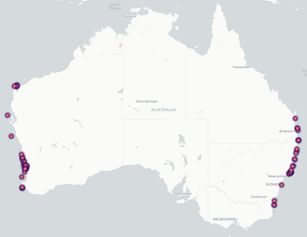
This dataset describes grey nurse shark (Carcharias taurus) listed, recognised and candidate aggregation sites in Australian waters, together with supporting individual acoustic-detection summaries from monitored aggregation sites. It consolidates previously documented site-level information on known, listed and candidate aggregation areas with time-series evidence of acoustically tagged shark detections. The project reviewed existing information on grey nurse shark aggregation sites and developed a revised definition for assessing aggregation status. Under this definition, an aggregation site is a discrete area where multiple grey nurse sharks are observed on a regular or predictable basis and where one or more behavioural functions may be inferred, including migration, resting, reproduction, feeding or undefined aggregation. The project also collected new survey and monitoring evidence from selected areas of potential grey nurse shark use, including Barwon Banks and the Hards in Queensland, Outer Gibber Reef in the Hunter Marine Park, and potential habitat in Gippsland, Victoria. These newly surveyed areas were not classified as confirmed aggregation sites as further monitoring is required to assess whether they support regular or predictable use by multiple grey nurse sharks. The data provided by this record include: • Aggregation-site data: a consolidated table of listed, recognised and potential grey nurse shark aggregation sites and associated information. • Individual detection data: collated acoustic telemetry detection summaries for tagged grey nurse sharks at monitored aggregation sites.
-
This record provides an overview of the NESP Marine and Coastal Hub Research Plan 2023 project "Eastern Grey Nurse Shark population abundance and trend". For specific data outputs from this project, please see child records associated with this metadata. -------------------- Grey nurse sharks are a nationally significant threatened species, with Australia’s eastern population listed as Critically Endangered under the EPBC Act. The Recovery Plan for the Grey Nurse Shark identifies the need for robust estimates of abundance, population trend, age structure, survival and range, particularly where conservation measures such as spatial closures and protection of aggregation sites are in place. This project refined abundance and trend estimates for the eastern Australian grey nurse shark population by combining biopsy sampling, genetic analysis, stereo-video length measurement and statistical modelling. Tissue samples from more than 300 sharks were analysed using close-kin mark-recapture methods to identify family relationships and estimate adult population size. Stereo-video measurements supported improved age estimation using Australian-specific length-at-age models, reducing reliance on overseas growth data. Findings from the project provide a stronger evidence base for Australian and New South Wales government decision-making on grey nurse shark recovery and conservation. Refined estimates of adult abundance and population trend (described in the Final Project Report) enables reduced uncertainty in recovery assessments, and supports evaluation of current management arrangements, including spatial protections for aggregation sites. Outputs • Final project report [written]
-
This record provides an overview of the NESP Marine and Coastal Hub Research Plan 2024 project "Grey Nurse Shark aggregations". For specific data outputs from this project, please see child records associated with this metadata. -------------------- Grey nurse sharks (Carcharias taurus) are protected in Australian Commonwealth waters. Under the EPBC Act, the eastern Australian population is listed as Critically Endangered, while the western Australian population is listed as Vulnerable. The species aggregates at particular sites along migration routes, but existing definitions and criteria for “key aggregation sites” require refinement to support consistent assessment across eastern and western Australia. This project collated existing information on recognised grey nurse shark aggregation sites and potential new sites where sharks have been observed to gather. It reviewed occupancy patterns, existing survey evidence and western population data to refine the definition of a key aggregation site and develop criteria for assessing whether sites should be listed, delisted or prioritised for further investigation. Field and data activities focused on areas where information was limited or where potential new aggregation sites had been identified. These included surveys in Victorian waters near Corner Inlet using ROV and eDNA methods in partnership with Gunaikurnai Land and Waters Aboriginal Corporation; community engagement with dive, fishing and freediving groups to improve reporting of observations; an initial BRUV survey of a reef system in Commonwealth waters in Hunter Marine Park; expanded acoustic receiver coverage at Barwon Banks in Queensland; and review of potential aggregation sites in Western Australia. The project outputs provided Commonwealth and state management agencies with a clearer, more defensible basis for identifying and assessing grey nurse shark aggregation sites. The resulting information supported consistent evaluation of existing and potential sites, prioritisation of future surveys, and improved conservation planning for both eastern and western grey nurse shark populations. Outputs • Spatial information on key Grey Nurse Shark aggregation sites [dataset] • Final project report [written]
-
This record provides an overview of the NESP Marine and Coastal Hub small-scale study - "Towards a consolidated and open-science framework for restoration monitoring". No data outputs were generated by this project. -------------------- Coastal habitat restoration is scaling up rapidly in Australia and covers a range of diverse ecosystems including oyster reefs, seagrass meadows, mangrove forests, kelp forests, and saltmarshes. While monitoring is commonly included in these projects, approaches are often uncoordinated, inconsistently funded, and rarely follow open science protocols. Previous NESP-funded projects have advanced understanding of the ecology and service provision of threatened ecosystems and established targets for repair based on reference conditions (e.g. Marine Biodiversity Hub project B4). They also created a national database of marine and coastal restoration projects (Australian Coastal Restoration Network: project E5) and supported the development of monitoring, evaluation, reporting and improvement (MERI) systems across various sectors. Building on this foundation, the current project synthesised monitoring approaches across multiple habitat types by drawing on the collective expertise of Australian researchers. It also explored the integration of emerging technologies—such as automation, artificial intelligence, and eDNA—to improve monitoring efficiency and cost-effectiveness. The primary output of this project is a coordinated, open-science monitoring framework that incorporates clearly defined restoration goals and a core set of universal variables. Developed through expert consultation, the framework supports consistent benchmarking across projects while accommodating habitat-specific and goal-driven metrics. The framework promotes data accessibility, standardised definitions, and the integration of new technologies to streamline the development of future restoration projects and maximise the value of restoration monitoring. Outputs • Best-practice toolkit / final project report [written]
-
This record provides an overview of the NESP Marine and Coastal Hub project "Updating knowledge of Australian white sharks". For specific data outputs from this project, please see child records associated with this metadata. -------------------- The white shark is listed as Vulnerable and Migratory under Australia’s Environment Protection and Biodiversity Conservation (EPBC) Act 1999. Previous NESP-funded research provided updated estimates of breeding population size and trend, but uncertainty remained around juvenile nursery and pupping areas, movement patterns, and connectivity between eastern and south-western Australian populations. More recent evidence has also raised the possibility of a single Australian population. This project aimed to reduce uncertainty in the status, trends and population structure of white sharks in Australian waters, with a focus on identifying biologically important habitats and improving population assessment through expanded close-kin mark-recapture (CKMR) analyses. The project combined three major components: (1) pilot tagging studies of large adult females and juvenile sharks to improve understanding of movements, pupping areas and habitat use; (2) genetic analyses to assess stock structure and connectivity using samples collected across Australia, and where possible from South Africa and New Zealand; and (3) updated population assessment using expanded tissue sample collections and close-kin mark-recapture methods. Population estimates incorporated approximately 1,000 tissue samples from New South Wales together with additional samples from South Australia and Western Australia. Juvenile abundance information from the New South Wales shark management program was also integrated into the assessment framework. CKMR approaches used genetic identification of parent-offspring and half-sibling relationships to estimate adult abundance, survival and population trends. Project outputs included updated estimates of population size and trend, improved understanding of population connectivity and movement patterns, and refined information on potential nursery and critical habitat areas. These findings support white shark recovery planning, future monitoring design, and conservation assessment in Commonwealth and state waters. Outputs • New genetic samples and sequencing data for white sharks [dataset] • Tracking data from PAT tags [dataset] • Final technical report (including recommendations for systematic future research to assist in identifying additional critical habitat for the south-western white shark population) [written]