 IMAS Metadata Catalogue
CSIRO Environment
Type of resources
Topics
Keywords
Contact for the resource
Provided by
Years
-

The Blue Economy CRC Futures of Seafood project is an initiative that maps, models and describes the spatial, economic and social impacts of the full suite of government policies and targets that impact ocean access on the seafood industry. This resource acts as a 'parent' record to collate IMAS-hosted data records relevant to the Futures of Seafood project delivered by CSIRO , in collaboration with NESP Marine and Coastal Hub Project 4.20.
-
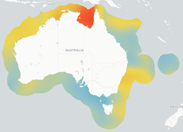
This project generated a set of high-quality eDNA-based biodiversity datasets from samples collected at broadly distributed offshore sites across Southeast Australia. The data consists of processed data from eDNA metabarcoding assays (i.e. tables with sampling information, sequence read counts and taxonomy derived from the sequences). Raw sequence data (over 180 million sequences) is available from NCBI (https://www.ncbi.nlm.nih.gov/) under BioProject PRJNA1263580: Environmental DNA measuring offshore marine biodiversity in southeast Australia (https://www.ncbi.nlm.nih.gov/bioproject/PRJNA1263580/). The eDNA biodiversity information focussed on fish but includes sequence data from the full tree of life (from bacteria to vertebrates). Part of the purpose of data collection was to assess key technical aspects of eDNA data collection to refine sampling methods and provide guidance for best practices in future offshore eDNA research
-

This record provides an overview of the NESP Marine and Coastal Hub Research Plan 2024 project "Environmental DNA for measuring offshore marine biodiversity: what can DNA in water collected from the RV Investigator tell us?". For specific data outputs from this project, please see child records associated with this metadata. -------------------- Environmental DNA (eDNA) in seawater provides a non-extractive way to characterise marine biodiversity from genetic material shed by organisms, from microbes and plankton to invertebrates and fishes. It is an emerging tool for marine ecosystem monitoring, particularly in offshore areas where conventional sampling can be difficult, costly or environmentally disruptive. This project collected and analysed more than 500 eDNA samples from 91 sites during the South-east Australian Marine Ecosystem Survey (SEA-MES) on RV Investigator. Samples were collected along the continental shelf between Tasmania and southern New South Wales, including sites within the South-east Marine Parks Network, providing the first comprehensive eDNA baseline for this region. The project tested active eDNA sampling from CTD water samples and passive eDNA sampling from a deep-towed camera system. DNA metabarcoding and Tree of Life metabarcoding were used to identify biodiversity patterns across the water column and near the seafloor. Results were compared with conventional survey methods, including fish trawls, plankton sampling and deep-towed camera deployments, to assess how eDNA complements existing monitoring approaches. The dataset revealed clear biodiversity patterns by depth, latitude, and water-column position, including higher fish diversity near the seafloor than at the surface. Comparisons with trawl and plankton data showed that eDNA provided complementary biodiversity information, supporting its use alongside existing survey methods and highlighting its value as part of integrated monitoring programs. The outputs provide a new biodiversity baseline for south-eastern Australian waters, and practical guidance on future application of eDNA techniques for offshore monitoring of marine parks and fisheries. Outputs • eDNA sequences with associated collection metadata (x2 voyages x50 sites) [dataset] • Final project report [written]
-
This project undertook a rapid exploration of information on a priority subset of species identified by the Department of Climate Change, Energy, the Environment and Water (DCCEEW) and the National Offshore Petroleum Safety and Environment Authority (NOPSEMA) that are listed as critically endangered or endangered under the Environment Protection and Biodiversity Conservation Act 1999. It specifically focused on these species in relation to the Gippsland declaration area, and the adjacent areas to the declaration area in Bass Strait. This rapid exploration of information was conducted as follows: 1) identify datasets and information sources relevant to priority species identified by DCCEEW and NOPSEMA for the Gippsland declaration area; 2) identify the source of these datasets and information and their level of accessibility; 3) evaluate the utility of datasets and information identified in 2) for assessments/regulatory processes required to be undertaken by DCCEEW and NOPSEMA; and 4) identify what activities would need to be undertaken to improve the accessibility and utility of datasets and information sources identified in 3) that are not currently accessible in useable formats. Fifteen priorities species (12 birds, 3 cetaceans) were identified for which publicly-available occurrence data could be located. This record and the attached download describes the data inventory for Swift Parrots (Lathamus discolor). To download the data inventory for all fifteen priority species, see https://doi.org/10.25959/GB51-RW44.
-

This record provides an overview of the NESP Marine and Coastal Hub Research Plan 2024 Emerging Priorities project "Modelling adult abundance and habitat distribution of Maugean skate". For specific data outputs from this project, please see child records associated with this metadata. -------------------- The Maugean skate (Zearaja maugeana) is listed as Endangered under Tasmania’s Threatened Species Protection Act 1995 and the Commonwealth Environment Protection and Biodiversity Conservation Act 1999. The species has one of the most restricted distributions of any extant elasmobranch, having only been recorded in Macquarie Harbour and Bathurst Harbour in western Tasmania. The Macquarie Harbour population is small (~3,000 individuals) and exposed to ongoing environmental pressures, making robust population assessment and habitat monitoring a high conservation priority. This project investigated Close Kin Mark Recapture (CKMR) as a priority method for estimating historical abundance and supporting long-term monitoring of Maugean skate in Macquarie Harbour, as identified in the species’ Roadmap of Agreed Actions and 2023 Conservation Advice. CKMR uses next-generation sequencing to identify close relatives among sampled individuals and model breeding population size, adult survival and population trends. A second project component modelled the distribution of critical Maugean skate habitat in relation to dissolved oxygen, temperature and depth. Telemetry data from tagged skates were combined with biophysical harbour models and habitat selection modelling to generate potential habitat maps for a 2017-18 hindcast period and forecast scenarios based on recent and evolving water-quality conditions. These maps were assessed against existing knowledge of skate habitat to identify critical areas within Macquarie Harbour and inform future spatial and temporal sampling strategies. Project outputs include independent population-assessment methods and hindcast/forecast habitat suitability maps for Macquarie Harbour. These outputs support conservation decision-making, evaluation of remediation scenarios, identification of critical habitat areas, and future monitoring and sampling design. Outputs • High-quality DNA sequences of Maugean skate [sequencing data] • Hindcast maps (2017-18) of potential Maugean skate occupation [spatial data] • Recent and forecast (evolving) maps of potential Maugean skate occupation under different management scenarios [spatial data] • Estimates of spawning stock abundance of the Maugean skate from CKMR analysis [data contained in written report] • Final project report [written]
-
This project undertook a rapid exploration of information on a priority subset of species identified by the Department of Climate Change, Energy, the Environment and Water (DCCEEW) and the National Offshore Petroleum Safety and Environment Authority (NOPSEMA) that are listed as critically endangered or endangered under the Environment Protection and Biodiversity Conservation Act 1999. It specifically focused on these species in relation to the Gippsland declaration area, and the adjacent areas to the declaration area in Bass Strait. This rapid exploration of information was conducted as follows: 1) identify datasets and information sources relevant to priority species identified by DCCEEW and NOPSEMA for the Gippsland declaration area; 2) identify the source of these datasets and information and their level of accessibility; 3) evaluate the utility of datasets and information identified in 2) for assessments/regulatory processes required to be undertaken by DCCEEW and NOPSEMA; and 4) identify what activities would need to be undertaken to improve the accessibility and utility of datasets and information sources identified in 3) that are not currently accessible in useable formats. Fifteen priorities species (12 birds, 3 cetaceans) were identified for which publicly-available occurrence data could be located. This record and the attached download describes the data inventory for the Southern Giant Petrel (Macronectes giganteus). To download the data inventory for all fifteen priority species, see https://doi.org/10.25959/GB51-RW44.
-
This project undertook a rapid exploration of information on a priority subset of species identified by the Department of Climate Change, Energy, the Environment and Water (DCCEEW) and the National Offshore Petroleum Safety and Environment Authority (NOPSEMA) that are listed as critically endangered or endangered under the Environment Protection and Biodiversity Conservation Act 1999. It specifically focused on these species in relation to the Gippsland declaration area, and the adjacent areas to the declaration area in Bass Strait. This rapid exploration of information was conducted as follows: 1) identify datasets and information sources relevant to priority species identified by DCCEEW and NOPSEMA for the Gippsland declaration area; 2) identify the source of these datasets and information and their level of accessibility; 3) evaluate the utility of datasets and information identified in 2) for assessments/regulatory processes required to be undertaken by DCCEEW and NOPSEMA; and 4) identify what activities would need to be undertaken to improve the accessibility and utility of datasets and information sources identified in 3) that are not currently accessible in useable formats. Fifteen priorities species (12 birds, 3 cetaceans) were identified for which publicly-available occurrence data could be located. This record and the attached download describes the data inventory for Humpback Whales (Megaptera novaeangliae). To download the data inventory for all fifteen priority species, see https://doi.org/10.25959/GB51-RW44.
-
This project undertook a rapid exploration of information on a priority subset of species identified by the Department of Climate Change, Energy, the Environment and Water (DCCEEW) and the National Offshore Petroleum Safety and Environment Authority (NOPSEMA) that are listed as critically endangered or endangered under the Environment Protection and Biodiversity Conservation Act 1999. It specifically focused on these species in relation to the Gippsland declaration area, and the adjacent areas to the declaration area in Bass Strait. This rapid exploration of information was conducted as follows: 1) identify datasets and information sources relevant to priority species identified by DCCEEW and NOPSEMA for the Gippsland declaration area; 2) identify the source of these datasets and information and their level of accessibility; 3) evaluate the utility of datasets and information identified in 2) for assessments/regulatory processes required to be undertaken by DCCEEW and NOPSEMA; and 4) identify what activities would need to be undertaken to improve the accessibility and utility of datasets and information sources identified in 3) that are not currently accessible in useable formats. Fifteen priorities species (12 birds, 3 cetaceans) were identified for which publicly-available occurrence data could be located: Australian Gould's Petrel (Pterodroma leucoptera leucoptera), Curlew Sandpiper (Calidris ferruginea), Eastern Curlew (Numenius madagascariensis), Grey-headed Albatross (Thalassarche chrysostoma), Mongolian Lesser Sand Plover (Charadrius mongolus), North-Eastern Siberian Red Knot (Calidris canutus), Northern Royal Albatross (Diomedea sanfordi), Orange-bellied Parrot (Neophema chrysogaster), Swift Parrot (Lathamus discolor), Shy Albatross (Thalassarche cauta), Southern Giant Petrel (Macronectes giganteus), Wedge-Tailed Eagle (Aquila audax), Blue Whale (Balaenoptera musculus), Southern Right Whale (Eubalaena australis), Humpback Whale (Megaptera novaeangliae). The data attached to this record outlines the data sources and access points located for each of the species listed above.
-
The National Environmental Science Program projects SS2 and D7 (under the Marine Biodiversity Hub) and 1.3 (under the Marine and Coastal Hub) were instigated to support the design of Monitoring Effectiveness (ME) framework for Australian Marine Park (AMP) estate, and contribute to the AMP Science Plan. The overall objective of these projects was to provide a nationally accepted common language to describe natural values and pressures, and a robust approach to combining this information to inform national priorities for monitoring inside AMPs. Broadly, the following approach was taken: 1. Identify Key Natural Values (KNVs) in AMP networks through an expert elicitation process, 2. Develop a national-scale ecosystem map via a combination of depth and characteristic habitat using the ME framework 3. Collate and synthesise pressures operating within Australia’s Exclusive Economic Zone and state/territory waters, as defined by the ME framework's pressures common language 4. Provide a spatially explicit analysis of the relative risks posed to marine conservation values, as defined by the ME framework’s natural values hierarchy. This record describes component 3: collating the pressures by ME common language for all of Australia’s Exclusive Economic Zone and state/territory waters; and determining the cumulative pressure exerted by each activity/sub-activity combination. Components 1, 2 & 4 are described elsewhere.
-
This record provides an overview of the NESP Marine and Coastal Hub Research Plan 2024 project "Delivery of science to support the implementation of a marine park management effectiveness system". For specific data outputs from this project, please see child records associated with this metadata. -------------------- Australian Marine Parks (AMPs) form one of the world’s largest marine park systems, protecting natural, cultural, social and economic values across Commonwealth waters. Parks Australia’s Management Effectiveness system supports adaptive management by assessing whether management arrangements are protecting park values and responding to changing pressures. This project supported implementation of the Australian Marine Parks Science Plan and delivered key science needs for the 2028 National AMP management plan review. It built on previous Marine Biodiversity Hub and Marine and Coastal Hub work on natural values, pressures, cumulative impacts, monitoring priorities and management effectiveness. The project delivered four linked outputs: 1) Monitoring protocols for Tier 1 and Tier 2 priority monitoring sites, including site-specific monitoring plans, data and survey method inventories, condition indicators, pressure indicators, and partnership case studies with Traditional Owners. 2) Improved workflows for assessing natural values, activities and pressures, including updates to pressure information, and establishment of data agreements and processes for regular updates. 3) Assessment approaches for emerging industries, using offshore renewable energy adjacent to AMPs as a test case to identify potential impacts such as underwater noise, seabed disturbance, sediment transport, vessel interactions, displacement of existing activities, and other future uses such as decommissioning or carbon storage. 4) Improved system-wide understanding of AMPs through collaboration with Parks Australia, state and territory marine protected area managers and fisheries managers, including opportunities to align data, indicators and management effectiveness approaches. The outputs provided Parks Australia with a more consistent evidence base for adaptive management, management plan review, monitoring design, pressure assessment and cross-jurisdictional collaboration across Australia’s marine park system. Outputs • Updated national-scale spatial datasets of: (1) Natural Values Ecosystems; (2) Key Natural Values; (3) Pressures & Activities; (4) Cumulative impacts; (5) Ecosystem-level risk assessment (absolute risk) [datasets] • Refined list of monitoring priorities for AMPs [written] • Monitoring protocols for monitoring priorities [written] • Final project report [written]