 IMAS Metadata Catalogue
ENVIRONMENTAL GOVERNANCE/MANAGEMENT
Type of resources
Topics
Keywords
Contact for the resource
Provided by
Years
-

This record provides an overview of the NESP Marine and Coastal Hub scoping study - "Scoping for an Australian Wetland Inventory: identifying knowledge gaps and solutions for mapping Australian marine and coastal wetlands". No data outputs were generated by this project. -------------------- Marine and coastal wetlands provide extensive ecosystem services—protecting shorelines, improving water quality, supporting healthy fisheries, promoting tourism, storing carbon, and holding cultural significance for Aboriginal and Torres Strait Islander people. Like many wetlands around the world, Australian wetlands continue to be threatened, degraded, and lost due to climate change, development, and other human activities. To support the Australian Government’s development of a national wetland inventory, this project assessed the current state of coastal wetland mapping across five key areas: seagrass, saltmarsh, intertidal macroalgae, shorebird habitat, and blue carbon. It identified major knowledge and inventory gaps through a combination of literature review and consultation with 73 end-users and experts, resulting in 25 targeted recommendations to guide future mapping and data integration. A summary of the status of mapping habitat attributes and ecosystem services such as blue carbon, coastal protection and shorebird habitat is available in the project's Final Technical Report. This report incudes recommendations to guide investment in high-demand areas and support nationally consistent wetland management and reporting to address key knowledge gaps. Outputs • Report reviewing and synthesising knowledge gaps in inventory mapping of marine and coastal wetlands, identifying effective solutions, and guiding subsequent research projects for enhancing wetland mapping [written]
-

This record provides an overview of the NESP Marine and Coastal Hub small-scale study - "Towards a consolidated and open-science framework for restoration monitoring". No data outputs were generated by this project. -------------------- Coastal habitat restoration is scaling up rapidly in Australia and covers a range of diverse ecosystems including oyster reefs, seagrass meadows, mangrove forests, kelp forests, and saltmarshes. While monitoring is commonly included in these projects, approaches are often uncoordinated, inconsistently funded, and rarely follow open science protocols. Previous NESP-funded projects have advanced understanding of the ecology and service provision of threatened ecosystems and established targets for repair based on reference conditions (e.g. Marine Biodiversity Hub project B4). They also created a national database of marine and coastal restoration projects (Australian Coastal Restoration Network: project E5) and supported the development of monitoring, evaluation, reporting and improvement (MERI) systems across various sectors. Building on this foundation, the current project synthesised monitoring approaches across multiple habitat types by drawing on the collective expertise of Australian researchers. It also explored the integration of emerging technologies—such as automation, artificial intelligence, and eDNA—to improve monitoring efficiency and cost-effectiveness. The primary output of this project is a coordinated, open-science monitoring framework that incorporates clearly defined restoration goals and a core set of universal variables. Developed through expert consultation, the framework supports consistent benchmarking across projects while accommodating habitat-specific and goal-driven metrics. The framework promotes data accessibility, standardised definitions, and the integration of new technologies to streamline the development of future restoration projects and maximise the value of restoration monitoring. Outputs • Best-practice toolkit / final project report [written]
-
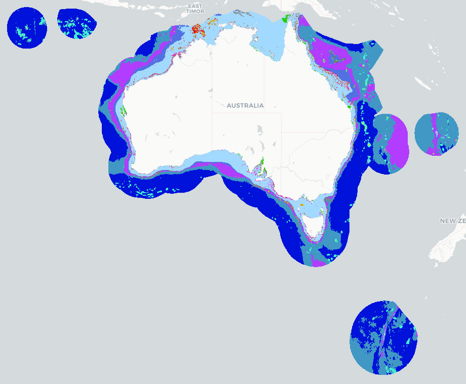
The Parks Australia Management Effectiveness (ME) system - previously MERI - is underpinned by a controlled, common language that provides a nationally consistent lexicon for a) Natural, cultural, and heritage values; (b) Social, cultural, and economic benefits; (c) Activities and anthropogenic pressures; and (d) Biophysical, and social and economic drivers. The Natural Values component of the common language is defined at three levels: 1) ecosystem complexes; 2) ecosystems; and 3) ecosystem components. This map shows the Ecosystems (tier 2) component of the Natural Values, and delineates features by habitat and depth for the Australian Exclusive Economic Zone (EEZ). This version (2025) of the National Values Ecosystems dataset uses Geoscience Australia's 250m resolution AusBathyTopo 2024 grid as the basis for the map. The dataset is an interim product between the 2022 version (https://doi.org/10.25959/HEKR-NR42) and an upcoming 2026 revision. The 2025 update incorporates revised and improved input datasets that have become available since the previous release. Several classification rules were updated to align with these inputs, including the use of Seamap Australia National Benthic Habitat Layer data as the primary source for mapped seagrass and coral reef occurrence. Note that this dataset uses a combination of input data sources and interpolates where data gaps exist. The common language adopts a functional, largely geo-physical perspective to define surrogates for marine ecosystems. This dataset is not a substitute for a validated habitat map (see Seamap Australia National Benthic Habitat Layer: https://metadata.imas.utas.edu.au/geonetwork/srv/eng/catalog.search#/metadata/4739e4b0-4dba-4ec5-b658-02c09f27ab9a), but has a national coverage and provides valuable broad-scale categorisation of marine ecosystems in Australian waters. See Hayes et al. 2021 and Dunstan et al. 2023 for a full definition of the Natural Values Ecosystem terms. See the 'lineage' section of this record for full processing notes.
-

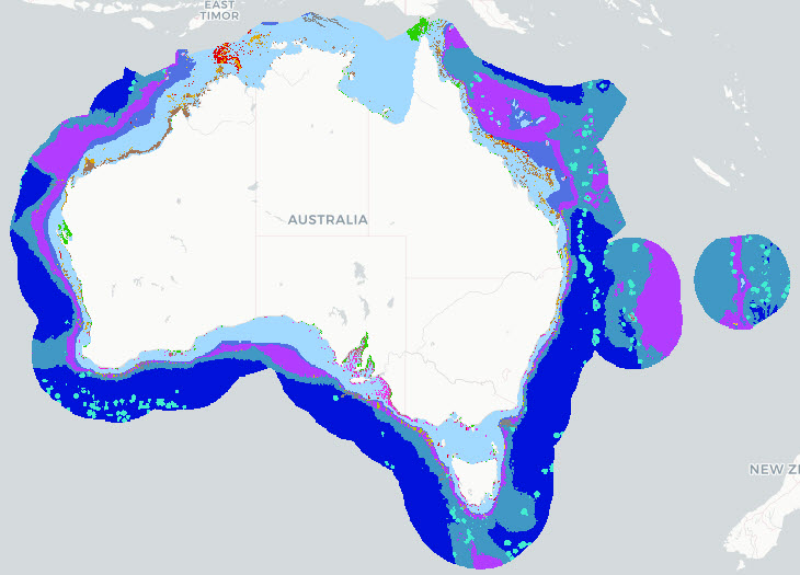
The Parks Australia Management Effectiveness (ME) system - previously MERI - is underpinned by a controlled, common language that provides a nationally consistent lexicon for a) Natural, cultural, and heritage values; (b) Social, cultural, and economic benefits; (c) Activities and anthropogenic pressures; and (d) Biophysical, and social and economic drivers. The Natural Values component of the common language is defined at three levels: 1) ecosystem complexes; 2) ecosystems; and 3) ecosystem components. This map shows the Ecosystems (tier 2) component of the Natural Values, and delineates features by habitat and depth for the Australian Exclusive Economic Zone (EEZ). This version (2026) of the National Values Ecosystems dataset uses Geoscience Australia's 250m resolution AusBathyTopo 2024 grid as the basis for the map. The dataset is currently in draft format and may be updated at any time. The 2026 update incorporates revised and improved input datasets that have become available since the previous release. Several classification rules were updated to align with these inputs, including the use of Seamap Australia National Benthic Habitat Layer data as the primary source for mapped seagrass and coral reef occurrence. Note that this dataset uses a combination of input data sources and interpolates where data gaps exist. The common language adopts a functional, largely geo-physical perspective to define surrogates for marine ecosystems. This dataset is not a substitute for a validated habitat map (see Seamap Australia National Benthic Habitat Layer: https://metadata.imas.utas.edu.au/geonetwork/srv/eng/catalog.search#/metadata/4739e4b0-4dba-4ec5-b658-02c09f27ab9a), but has a national coverage and provides valuable broad-scale categorisation of marine ecosystems in Australian waters. See Hayes et al. 2021 and Dunstan et al. 2023 for a full definition of the Natural Values Ecosystem terms. See the 'lineage' section of this record for full processing notes.
-
The Parks Australia Management Effectiveness (ME) system - previously MERI - is underpinned by a controlled, common language that provides a nationally consistent lexicon for a) Natural, cultural, and heritage values; (b) Social, cultural, and economic benefits; (c) Activities and anthropogenic pressures; and (d) Biophysical, and social and economic drivers. The Natural Values component of the common language is defined at three levels: 1) ecosystem complexes; 2) ecosystems; and 3) ecosystem components. This map shows the Ecosystems (tier 2) component of the Natural Values, and delineates features by habitat and depth for the Australian Exclusive Economic Zone (EEZ). This version (2022) of the National Values Ecosystems dataset uses Geoscience Australia's 250m resolution Australian Bathymetry and Topography Grid, 2009 (https://dx.doi.org/10.4225/25/53D99B6581B9A) as the basis for the map. See Hayes et al. 2021 and Dunstan et al. 2023 for a full definition of Natural Values Ecosystem terms, input datasets used, and processing steps involved with the creation of this map. Note that this dataset uses a combination of input data sources and interpolates where data gaps exist. The common language adopts a functional, largely geo-physical perspective to define surrogates for marine ecosystems. This dataset is not a substitute for a validated habitat map (see Seamap Australia National Benthic Habitat Layer: https://metadata.imas.utas.edu.au/geonetwork/srv/eng/catalog.search#/metadata/4739e4b0-4dba-4ec5-b658-02c09f27ab9a), but has a national coverage and provides valuable broad-scale categorisation of marine ecosystems in Australian waters. ***An updated version of this data product is available - see https://doi.org/10.25959/7SXA-DX47***
-

This record provides an overview of the NESP Marine and Coastal Hub project "Ecological outcomes of wastewater discharges in contrasting receiving environments". For specific data outputs from this project, please see child records associated with this metadata. -------------------- Coastal and marine environments are increasingly exposed to pollution from land-based sources, including wastewater. With the majority of Australians living near the coast, household chemicals, pharmaceuticals, and plastics can enter the ocean via wastewater treatment plant outfalls. National policies and action plans, including Australia’s Waste Policy Action Plan, the Threat Abatement Plan for the impacts of marine debris, and the One Health Master Action Plan, all emphasise the need to incorporate emerging pollutants into contaminant guidelines. However, current monitoring programs focus on a limited set of contaminants, leaving major gaps in our understanding of the presence, concentration, and ecological effects of emerging pollutants in the marine environment. This project addressed this problem by: (1) identifying priority pollutants of concern; (2) determining concentrations of Chemicals of Emerging Concern (CEC) at a range of wastewater outfall sites with varying hydrodynamic settings; and (3) assessing where environmental impacts are likely to be greatest. It focused on five key pollutant groups: microplastics, nutrients, heavy metals, PFAS (per- and polyfluoroalkyl substances), and antimicrobials. Hydrodynamic modelling was used to evaluate residence times and pollutant dispersal in selected marine settings, and field sampling was conducted to assess contaminant levels and potential ecological impacts on the lower food web. The project built on the findings of NESP Marine and Coastal Hub Scoping Study 1.16, which identified the need for impact assessments for CECs. The project generated new knowledge to inform risk assessments of emerging contaminants in the marine environment and provides recommendations for prioritising future monitoring and investment. It also enhances access to wastewater discharge data through continued development of the National Outfall Database. Outputs • Measures of CEC (contaminants of emerging concern) and microbial community composition in water and sediment samples taken from outfall sites [dataset] • Final project report [written]
-

This record provides an overview of the NESP Marine and Coastal Hub project "Improving knowledge transfer to support Australian Marine Park decision making and management effectiveness evaluation". For specific data outputs from this project, please see child records associated with this metadata. -------------------- Australia’s network of Commonwealth Marine Parks plays a central role in conserving marine biodiversity, supporting sustainable use, and protecting cultural and recreational values. With over 60 parks spanning diverse habitats - from shallow coastal areas to deep offshore canyons - effective and adaptive management depends on access to reliable, fit-for-purpose data and data products that reflect the condition of park values and the pressures acting upon them. This project improved the capacity to assess the effectiveness of Australian Marine Park (AMP) management by identifying and evaluating priority data and data products required for characterising marine systems and management effectiveness. It worked closely with Parks Australia to assess the availability, quality, and delivery mechanisms of existing datasets, and determined whether these were operationally viable, maintainable over time, and aligned with FAIR data principles. Technical assessments considered consistency of formats, use of standardised vocabularies, as well as machine-readability and the use of national standards for data and collection methodologies. Using available data, knowledge, and existing data infrastructure, the project developed methods for estimating the condition of AMP values (excluding cultural values) and for assessing management effectiveness. Recommendations were provided to improve the discoverability, accessibility, and usability of priority data products through national platforms. Outcomes of the project include a clearer understanding of existing data gaps and a practical foundation for improving future AMP assessments. Parks Australia was equipped with a structured assessment of current data suitability and availability, a demonstration of condition estimation methods, and strategic recommendations to enhance data delivery and alignment with park management cycles. This work directly contributes to the Marine and Coastal Hub’s Protected Place Management Initiative and supports national efforts to build integrated data systems for marine estate monitoring and reporting. Outputs • Documented data and data product priorities organised in one or more data product hierarchies including monitoring priorities and their indicators where appropriate [written] • A fit for purpose assessment of priority data products [written] • Methods for estimating current condition status of AMP values [written] • Recommendations for how to progress priority data sets that do not currently meet the established criteria but are required for characterising, protecting, and assessing current condition status of AMP values [written] • Final project report [written] • Ad-hoc data products generated through this project's data fitness-for-purpose exercise - see linked 'child' records
-
This record provides an overview of the NESP Marine and Coastal Hub project "Synthesis of environmental values to support the review of Australian Marine Park management plans". For specific data outputs from this project, please see child records associated with this metadata. -------------------- Parks Australia (Australian Government) manage 60 Australian Marine Parks (AMPs) around the country, covering an area of 3.8 million square kilometres, or 43% of all Australian waters. The approach to managing AMPs is set out in eight Management Plans, one for each of the five marine park networks (North, North-west, South-west, South-east and Temperate East) and one each for the Coral Sea Marine Park, Christmas Island Marine Park and Cocos (Keeling) Islands Marine Park. A statutory review of Management Plans for the North, North-west, South-west, Temperate-East networks and the Coral Sea Marine Park is scheduled for 2028. This review requires accessible, synthesised evidence on science outputs, natural values, socio-economic values and pressures across parks and networks. This project supports the 2028 statutory review by synthesising relevant NESP Marine Biodiversity Hub, NESP Marine and Coastal Hub, and Parks Australia-contracted work from 2017 onwards. These reports bring together science outputs, natural values, pressures and socio-economic information from 2017 onwards, aggregated where possible to Park and Network scales. The project reviewed the data summaries, workflows and reporting tools used to prepare the synthesis reports, and identified opportunities to better integrate this infrastructure. These recommendations support future AMP management effectiveness reporting, statutory review processes, and national environmental assessment and impact reporting. Outputs • Catalogue of available data for each reviewed Network (North, North-west, South-west, Temperate East) and the Coral Sea AMP [data inventory] • Synthesis report [written] for each region that will include: - a summary of science activity and outputs since 2017 - summaries of the state and trend of Natural Values and Pressures since 2017, aggregated by Ecosystem Component, Ecosystem Depth Zone, AMP, and AMP Zone type (where possible) • Final technical report (including recommendations to support AMP management and reporting) [written]
-

This record provides an overview of the NESP Marine and Coastal Hub project "Improving socio-ecological understanding of natural values in Australian Marine Parks". No public data outputs will be generated by this project. -------------------- Parks Australia (Australian Government) manage 60 Australian Marine Parks (AMPs) around the country, covering an area of 3.8 million square kilometres, or 43% of all Australian waters. The approach to managing AMPs is set out in eight Management Plans: one for each of the five marine park networks (North, North-west, South-west, South-east and Temperate East) and one each for the Coral Sea Marine Park, Christmas Island Marine Park and Cocos (Keeling) Islands Marine Park. A statutory review of Management Plans for the North, North-west, South-west, Temperate-East networks and the Coral Sea Marine Park is scheduled for 2028. Socio-economic information is needed alongside natural values data to assess management effectiveness and understand how Australians use, value and perceive the marine park system. This project progressed the use of socio-economic information to support Australian Marine Park management and the 2028 management plan review. It builds on previous NESP research by redeveloping socio-economic benchmarks aligned with Parks Australia’s sentinel park approach and network-scale reporting, and complements NESP-led data synthesis projects (SS2, D7, 1.3, 4.20 and 4.21). The project redesigned two repeatable national surveys: a knowledge, attitudes and practice boat ramp survey targeting recreational fishers and non-fishers who use Australian Marine Parks, and a general public survey exploring broader community awareness, attitudes and views on management zones. Nine boat-ramp survey locations were selected with Parks Australia to support park- and network-scale estimates of recreational use covering the Coral Sea, and North, North-west, South-west, South-east and Temperate East networks. The survey design and sampling regime provide a basis for assessing changes in awareness, attitudes and use patterns since the 2019/20 benchmark. Combined with natural values data, these outputs strengthen the Management Effectiveness system and support more integrated reporting on the social, economic and ecological values of Australian Marine Parks. Outputs • Responses from recreational user surveys [dataset]. In accordance with National Statement on Ethical Conduct in Human Research, only aggregated outputs will be made publicly available. • Final technical report [written]
-
An assessment was made of the state of research knowledge in the Australian Marine Parks (2022 boundaries). This quality assessment is specifically of the suitability of data streams for deriving habitat maps. Five nationally-aggregated data streams were used in the assessment: (1) Seamap Australia (seafloor habitat) (2) AusSeabed bathymetry survey extents (bathymetry mapping) (3) Squidle+ imagery deployments (habitat observations) (4) GlobalArchive video deployments (habitat observations) (5) Geoscience Australia's Marine Sediment Database (MARS) From these data streams, quality ratings (0-5) have been made for the state of research knowledge for three research disciplines: (A) bathymetry maps; (B) habitat observations; and (C) habitat maps. Data quality assessments are reported for each AMP Network and Park. Assessments can be accessed in context at https://seamapaustralia.org/region-reports, via the State-of-Knowledge functionality in the Seamap Australia mapping portal: https://seamapaustralia.org/map, or as a stand-alone file in the 'Downloads' section of this record. This data is live and is refreshed weekly.