 IMAS Metadata Catalogue
COMMUNITY STRUCTURE
Type of resources
Topics
Keywords
Contact for the resource
Provided by
Years
-
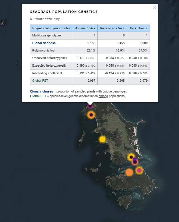
Seagrass beds are a dominant marine ecosystem of Tayaritja (the Furneaux Group of Islands) in the north-eastern waters off Tasmania. Historical coarse mapping has indicated extensive beds of Posidonia, Amphibolis, Heterozostera, and Zostera species, potentially comprising some of the largest and deepest seagrass extents found in temperate Australian waters. However, limited data on the distribution and ecological value of these seagrass habitats represents a significant knowledge gap in understanding Australia's wetland natural assets. This project mapped the extent, ecological composition, population structure, and blue carbon value of seagrass beds around Tayaritja, in partnership with the Tasmanian Aboriginal Centre. This record specifically describes the seagrass population genetics component of the project. Leaf tissue samples were collected from four seagrass species: Amphibolis antarctica, Heterozostera nigricaulis, Posidonia australis and Zostera muelleri. Samples were collected from multiple sites around Tayaritja Sea Country and processed for genome-wide SNP genotyping using the DArTseq platform. The dataset includes population-level genetic summary statistics, associated DArT metadata and reports, and raw sequence data used to support assessment of genetic diversity, clonality, population structure and connectivity among sampled seagrass populations. See the "Lineage" section of this record for full methodology. ***EMBARGO NOTE*** Data is currently embargoed until 31/12/2026. Please contact the NESP Data Wrangler (Southern node) to discuss access options: Emma.Flukes@utas.edu.au
-
Observational data for the Kelp Ecosystem Ecology Network. These data come from transects of rocky reefs taken around the world using the KEEN observational data protocol (see http://kelpecosystems.org for full description of methods and handbook). See “How” for methods. Briefly, the observational data consists of the following components, all included here: site information, fish observations, quadrat sampling, band transect sampling, percent cover from uniform point counts, and kelp morphometrics. Data Files Data files included and what they contain are as follows: keen_sites.csv - Physical and locational data for all KEEN sites and transect. keen_cover.csv - Percent cover of sessile algae and invertebrates. keen_fish.csv - Counts of fish by size class along a transect. keen_quads.csv - Counts of common algae, sessile invertebrates, and demersal fish that can be individuated. keen_swath.csv - Counts of rarer algae, sessile invertebrates, and demersal fish that can be individuated. Data Use To use the observational data here for published work we ask that 1) You contact the network coordinator, jarrett.byrnes@umb.edu, and notify them of your intention so that we can coordinate among any ongoing projects using the same data, 2) if the data has not been used in a publication in the literature before, we request that you reach out to the PIs responsible for the data you will be using and engage in a conversation about co-authorship, 3) if it has been used previously, merely cite the datasets associated with each PI that you use. The references are listed below. For access to the entire data cleaning and processing pipeline, see https://github.com/kelpecosystems/observational_data. For access to scans of the original data sheets, contact jarrett.byrnes@umb.edu. ------------------------------------------------------ For general methods: Byrnes, Jarrett E.K., Haupt, Alison J., Reed, Daniel C., Wernberg, Thomas., Pérez-Matus, Alejandro., Shears, Nick T., Konar, Brenda, Gagnon, Pat, and Vergés, Adriana. 2014. Kelp Ecosystem Ecology Network Monitoring Handbook. Kelp Ecosystem Ecology Network. For specific data sets, use the following, but also include date the data is accessed from this record in order to track the data version used. Byrnes, Jarrett E.K., Haupt, Alison J., Lyman, Ted. 2014. Kelp forest communities at Appledore Island, the Boston Harbor Islands, and Salem Sound. Kelp Ecosystem Ecology Network. Dijkstra, Jennifer A., Mello, Kristen. 2015. Kelp forest communities at York, Maine. Kelp Ecosystem Ecology Network. Grabwoski, Jonathan and MacMahan, Marissa. 2015. Kelp forest communities in Nahant, Massachusetts, and Pemaquid, Maine. Kelp Ecosystem Ecology Network. Humphries Austin T., Paight C, Ben-Horin Tal, Green Lindsay, Thornber, Carol. 2016. Kelp forest communities in Narragansett Bay, Rhode Island. Kelp Ecosystem Ecology Network. Rasher, Douglass and Price, Nicole. 2017. Kelp forest communities of central and downeast Maine. Kelp Ecosystem Ecology Network. Peréz-Matus, Alejandro and Shaughnessy, Brianna. 2017. Kelp forest communities of central and northern Chile. Kelp Ecosystem Ecology Network.
-
The data is quantitative abundance of fish, megafaunal invertebrates and percent algal cover derived from underwater visual census methods involving transect counts at rocky reef sites around Tasmania. This dataset allows examination of changes in Tasmanian shallow reef faunal and floral communities over a decadal scale, with initial surveys conducted in 1992-1995, and again in 2006-2007. There are plans for ongoing surveys. An additional component was added in the latter study - a boat ramp study looking at the proximity of boat ramps and their effects of fishing. We analysed underwater visual census data on fishes and macroinvertebrates (abalone and rock lobsters) at 133 shallow rocky reef sites around Tasmania that ranged from 0.6 - 131 km from the nearest boat ramp. These sites were not all the same as those used for the comparison of 1994 and 2006 reef communities. The subset of 133 sites examined in this component consisted of only those sites that were characterized by the two major algal (kelp) types (laminarian or fucoid dominated). Sites with atypical algal assemblages were omitted from the 196 sites surveyed in 2006. This study aimed to examine reef community data for changes at the community level, changes in species richness and introduced species populations, and changes that may have resulted from ocean warming and fishing. The methods are described in detail in Edgar and Barrett (1997). Primarily the data are derived from transects at 5 m depth and/or 10 m depth at each site surveyed. The underwater visual census (UVC) methodology used to survey rocky reef communities was designed to maximise detection of (i) changes in population numbers and size-structure (ii) cascading ecosystem effects associated with disturbances such as fishing, (iii) long term change and variability in reef assemblages.
-
The data is the percent algal cover derived from underwater visual census methods involving transect counts at rocky reef sites around Tasmania. This data forms part of a larger dataset that also surveyed fish and megafaunal invertebrate abundance for the area. The aggregated dataset allows examination of changes in Tasmanian shallow reef floral and faunal communities over a decadal scale - initial surveys were conducted in 1992-1995, and again at the same sites in 2006-2007. There are plans for ongoing surveys. An additional component was added in the latter study - a boat ramp study looking at the proximity of boat ramps and their effects of fishing. We analysed underwater visual census data on fishes and macroinvertebrates (abalone and rock lobsters) at 133 shallow rocky reef sites around Tasmania that ranged from 0.6 - 131 km from the nearest boat ramp. These sites were not all the same as those used for the comparison of 1994 and 2006 reef communities. The subset of 133 sites examined in this component consisted of only those sites that were characterized by the two major algal (kelp) types (laminarian or fucoid dominated). Sites with atypical algal assemblages were omitted from the 196 sites surveyed in 2006. This study aimed to examine reef community data for changes at the community level, changes in species richness and introduced species populations, and changes that may have resulted from ocean warming and fishing. The methods are described in detail in Edgar and Barrett (1997). Primarily the data are derived from transects at 5 m depth and/or 10 m depth at each site surveyed. The underwater visual census (UVC) methodology used to survey rocky reef communities was designed to maximise detection of (i) changes in population numbers and size-structure (ii) cascading ecosystem effects associated with disturbances such as fishing, (iii) long term change and variability in reef assemblages.
-
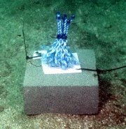
Community assembly in macrofauna communities developed in artificial kelp holdfasts was monitored at 1-month intervals over a 13 month period using a sampling design that used systematic patterns of temporal overlap and changes in start and collection dates. The hierarchical nature of the experimental design allowed several different approaches to analysis; by date of deployment and by date of collection of the artificial habitats, which enabled comparison of community assembly with and without the seasonal effects of the date of collection, and by community age to test whether there were alternative end-states to assembly depending on season or recruitment history.
-
Diel partitioning of animals within ecological communities is widely acknowledged, yet rarely quantified. Investigation of most ecological patterns and processes involves convenient daylight sampling, with little consideration of the contributions of nocturnal taxa, particularly in marine environments. Here we assess diel partitioning of reef faunal assemblages at a continental scale utilizing paired day and night visual census across 54 shallow tropical and temperate reefs around Australia. Day/night differences were most pronounced in the tropics, with fishes and invertebrates displaying distinct and opposing diel occupancy on coral reefs. Tropical reefs in daytime were occupied primarily by fishes not observed at night (64% of all species sighted across day and night, and 71% of all individuals). By night, substantial emergence of invertebrates not otherwise detected during sunlit hours occurred (56% of all species, and 45% of individuals). Nocturnal emergence of tropical invertebrates corresponded with significant declines in the richness and biomass of predatory and herbivorous diurnal fishes. In contrast, relatively small diel changes in fishes active on temperate reefs corresponded to limited nocturnal emergence of temperate invertebrates. This reduced partitioning may, at least in part, be a result of strong top-down pressures from fishes on invertebrate communities, either by predation or competitive interference. For shallow reefs, the diel cycle triggers distinct emergence and retreat of faunal assemblages and associated trophic patterns and processes, which otherwise go unnoticed during hours of regular scientific monitoring. Improved understanding of reef ecology, and management of reef ecosystems, requires greater consideration of nocturnal interactions. Without explicit sampling of nocturnal patterns and processes, we may be missing up to half of the story when assessing ecological interactions.
-
The Tasman Fracture CMR AUV survey was a pilot study undertaken in 2014/15 as part of the National Marine Biodiversity Hub's National monitoring, evaluation and reporting theme. The aim of this theme is to develop a bluepint for the sustained monitoring of the South-east Commonwealth Marine Reserve Network. The particular aim of the survey was to contribute to an inventory of the distribution and abundance of demersal fishes in the reserve and adjacent reference sites using BRUVs. Data contained here represents footage collected using these drops and the associated scored data (abundance and lengths).
-
The data is the quantitative abundance of megafaunal invertebrates derived from underwater visual census methods involving transect counts at rocky reef sites around Tasmania. This data forms part of a larger dataset that also surveyed fish abundance and algal cover for the area. The aggregated dataset allows examination of changes in Tasmanian shallow reef floral and faunal communities over a decadal scale - initial surveys were conducted in 1992-1995, and again at the same sites in 2006-2007. There are plans for ongoing surveys. An additional component was added in the latter study - a boat ramp study looking at the proximity of boat ramps and their effects of fishing. We analysed underwater visual census data on fishes and macroinvertebrates (abalone and rock lobsters) at 133 shallow rocky reef sites around Tasmania that ranged from 0.6 - 131 km from the nearest boat ramp. These sites were not all the same as those used for the comparison of 1994 and 2006 reef communities. The subset of 133 sites examined in this component consisted of only those sites that were characterized by the two major algal (kelp) types (laminarian or fucoid dominated). Sites with atypical algal assemblages were omitted from the 196 sites surveyed in 2006. This study aimed to examine reef community data for changes at the community level, changes in species richness and introduced species populations, and changes that may have resulted from ocean warming and fishing. The methods are described in detail in Edgar and Barrett (1997). Primarily the data are derived from transects at 5 m depth and/or 10 m depth at each site surveyed. The underwater visual census (UVC) methodology used to survey rocky reef communities was designed to maximise detection of (i) changes in population numbers and size-structure (ii) cascading ecosystem effects associated with disturbances such as fishing, (iii) long term change and variability in reef assemblages.
-
Data is PCR amplification results of southern rock lobster (Jasus edwardsii) faecal material tested for sea urchin DNA (using unique primers for Centrostephanus rodgersii and Heliocidaris erythrogramma) in an attempt to determine in situ rates of consumption of sea urchins by lobsters. An efficient and non-lethal method was used to source and screen lobster faecal samples for the presence of DNA from ecologically important sea urchins. Lobster faecal samples were collected from trap caught specimens sourced in winter & summer seasons over 2 years (2009-2011) within two no-take research reserves; declared specifically for the purpose of rebuilding large predatory-capable lobsters to assess the potential for predator-driven remediation of kelp beds on rocky reefs extensively overgrazed by sea urchins (North Eastern Tasmania) and reefs showing initial signs of overgrazing (South Eastern Tasmania). Data for molecular assays showed high variability in the proportion of lobsters testing positive to sea urchins, with significant variability detected across different years and seasons but this was found to vary depending on different lobster size-classes. Sea urchin DNA was also amplifiable from sediments and urchin faeces collected from the reef surface where urchins occurred in high abundance. Furthermore, positive sea urchin DNA assays were obtainable from lobster faeces after lobsteres were fed sediment and urchin faecal material. Rates of predation obtained with genetics tests can also be compared to independent rates of urchin losses given known lobster abundances within research reserves (and at control sites). Data of changes in urchin abundances and lobster abundances are therefore also lodged as part of this record.
-
The long spined sea urchin Centrostephanus rodgersii (Diadematidae) has recently undergone poleward range expansion to eastern Tasmania (southeast Australia). This species is associated with barrens habitat which has been grazed free of macroalgae, and therefore has potentially important consequences for reef structure and biodiversity. This study used urchin removal experiments from barrens patches in eastern Tasmania to monitor the subsequent response of the macroalgae relative to unmanipulated barrens patches. In removal patches, there was a rapid proliferation of canopy-forming macroalgae (Ecklonia radiata and Phyllospora comosa), and within 24 months the algae community structure had converged with that of nearby areas without urchins. Faunal species richness was comparatively low in barrens habitat, with C. rodgersii grazing activity resulting in an estimated minimum net loss of approximately 150 taxa compared with intact macroalgal habitats.