 IMAS Metadata Catalogue
BATHYMETRY/SEAFLOOR TOPOGRAPHY
Type of resources
Topics
Keywords
Contact for the resource
Provided by
Years
-
Bathymetric contours (5 m interval) for Tasmanian coastal waters from the LWM (Low water mark) to 40 metres in depth or 1.5 kms from shore (whichever boundary is first identified). Detailed bathymetric contours were developed to be used to fulfill coastal management objectives according to The Living Marine Resources Act 1995.
-
This record provides an overview of the NESP Marine and Coastal Hub bridging study - "Characterising natural values and identifying indicators and metrics in South-west Corner Marine Park". For specific data outputs from this project, please see child records associated with this metadata. -------------------- Inventory surveys of Australian Marine Parks (AMPs) provide a broad description of the natural assets that exist in Commonwealth waters. These data can be further explored to identify biological indicators and metrics to cost-effectively monitor the AMPs and inform the AMP Monitoring Evaluation Reporting and Improvement (MERI) system. Historical surveys conducted under the NESP Marine Biodiversity Hub inventoried natural values and ecosystem components in selected AMPs. They developed and tested standardised survey techniques to allows scientists and park managers to identify and measure the status of natural values and ecosystem components. A recent Marine Biodiversity Hub survey conducted detailed bathymetric and visual sampling of key seafloor habitat and fish assemblages in the Capes region of South-west Corner Marine Park (Western Australia). This project analysed the Capes survey data to characterise and predict the broader distribution of natural values and ecosystem features, and to identify relevant indicators of fish and benthic assemblages for Park management. The results are presented alongside summaries of existing knowledge on natural, socio-economic, and cultural values, as well as human pressures. Recommendations include establishing national and international monitoring benchmarks and incorporating survey guidance from Traditional Owners. Outputs • Habitat annotations for AUV & drop camera imagery [dataset] • Habitat map using existing fine-scale bathymetry coverage (validated by drop camera surveys) [dataset] • Annotations of fish and shark size, abundance and diversity from stereo-BRUV deployments [dataset] • Science communication article for the Australian Marine Parks Science Atlas [written] • South-west Corner Marine Park survey report [written]
-

This record provides an overview of the NESP Marine and Coastal Hub scoping study - "National Areas of Interest for Seabed Mapping, Characterisation and Biodiversity Assessment". For specific data outputs from this project, please see child records associated with this metadata. -------------------- Seabed and marine biodiversity data are time-consuming and costly to collect, so it is imperative that acquisition is focused on areas that align with end user priorities. The value that different stakeholders place on seabed and biodiversity data can be difficult to determine. Therefore, a shared process for identifying survey priorities is required to ensure the maximum shared benefit of future survey investment across research users, funding agencies, infrastructure providers, as well as the wider marine research community. The project aimed to assist with the planning and prioritisation of marine surveys (both physical and biological) by scoping a prioritisation framework for marine surveys undertaking physical and biological seabed data collection in Australia. Focused workshops and targeted engagements with seabed mapping organisations were used to develop a standard set of metadata for agencies to define spatial Areas of Interest (AOI). The standard metadata were used in a prototype prioritisation framework that allows users to transparently and consistently rank and prioritise survey work or data delivery processes. The prioritisation is then based on rankings established by defined sets of criteria. A web-based AOI submission tool and mapping publication service was then developed for these defined areas as part of the AusSeabed Survey Coordination Tool. Adoption of this tool facilitates the development of an interim national areas of interest product to inform future survey planning. This product supports both the needs of Parks Australia's network Science Plans, and consideration of information needs for Indigenous Protected Areas within Sea Country. Outputs • National Areas of Interest polygon & interactive map [dataset] • Code for Survey Coordination Tool [Github Repo] • Final Report with Value Prioritisation Framework [written]
-

Ocean Infinity (Australia) Pty Ltd (formerly iXblue Pty Ltd), in partnership with Deakin University’s Marine Mapping Group, University of Wollongong, Tellus4D Geoimaging, University of Newcastle, University of New South Wales, University of Tasmania, and Geoscience Australia, undertook a combined aerial and hydrographic survey as part of the Norfolk Island Nearshore and Coastal Habitat Mapping project under Parks Australia Grant Activity ID 4-FISKTDM. The work aimed to establish a detailed baseline of Norfolk Island’s nearshore coastal and shelf environments to inform management, conservation, and research. From 21 to 24 July 2021, 109 km² of the Norfolk Shelf was mapped using high-resolution multibeam sonar, along with two sub-bottom profiles. These were supplemented by 44 Baited Remote Underwater Video (BRUV) deployments in the northeast and south of the island to assess fish assemblages and provide ground truthing data for interpretation of seabed nature. In November 2021, a separate coastal survey using high-resolution drone photogrammetry captured geomorphic and habitat information at seven coastal sites: Captain Cook Lookout, Anson Bay, Puppy’s Point, Headstone Point, Slaughter Bay and Bombora Beach, and Cemetery and Emily Bay. These locations span a variety of morphologies, from exposed basaltic shore platforms and dramatic cliffs to offshore stacks and pockets of rocky beach. The data collected by the project provides a detailed view of the marine and coastal geomorphology of Norfolk Island. The data provides an initial condition assessment of key areas to inform park management, habitat protection, and future targeted studies such as further bathymetric mapping in sensitive areas and expanded ground-truthing of seabed habitats.
-

Fine-scale bathymetry mapping was conducted in the Franklin and Zeehan Australian Marine Parks (AMPs) located off the west coast of Tasmania, Australia. The primary objective of this mapping exercise was to map seafloor features of the shelf areas of these AMPs for the first time and to understand the distribution of benthic habitats and key sessile invertebrate species within these areas. Characterisation of the seafloor was undertaken in two phases. The first stage used multibeam sonar to comprehensively map the study areas, extracting bathymetry and backscatter products. This was followed by extensive ground validation undertaken by a panoramic stereo drop-camera system that also recorded the presence of dominant sessile invertebrate fauna as well as benthic/demersal fish species. This record describes and provides data access to the fine-scale substratum mapping extracted from the combination of multibeam bathymetry and video ground-truthing data. Access to the (1) bathymetry survey data; and (2) annotated seafloor imagery, are provided through the 'Download and Links' section of this record.
-
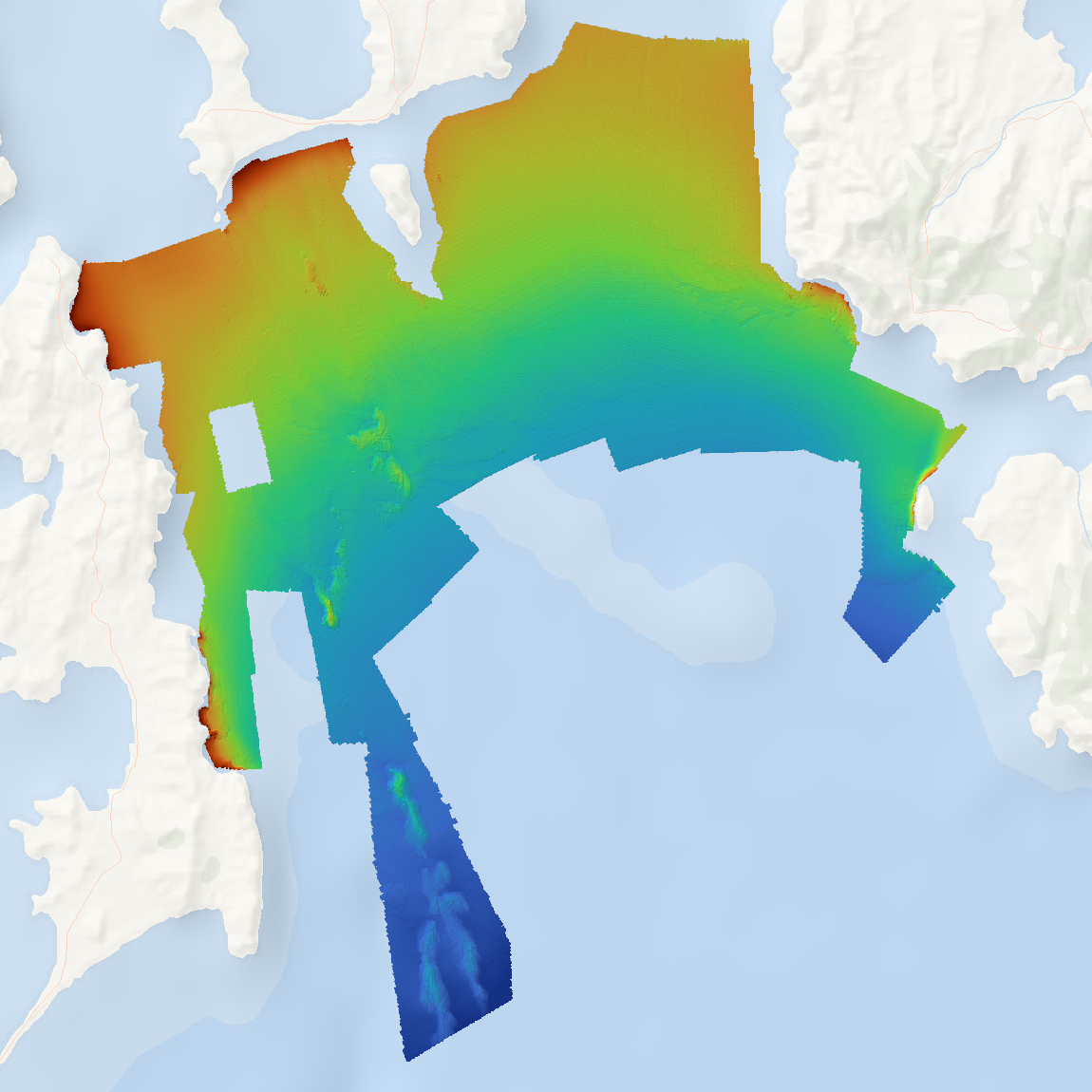
High resolution bathymetry data was collected for Storm Bay, Tasmania as part of the FRDC project 2018-131 'Storm Bay Observing System: Assessing the Performance of Aquaculture Development. Objective 2: Provide a comprehensive map of benthic habitats and bathymetry of the Storm Bay region and assessment of change at key focus areas'. Data is supplied as a single Web Map Service of hillshaded bathymetry for the mapped region. Data is available for download as (1) bathymetry, and (2) hillshade tiff files.
-
These data describe quantitative exposure indices generated using cartographic fetch methods on a 0.01 degree grid across temperate Australia (South Australia, Victoria and Tasmania). Two indices are reported: openness and bathymetry-altered fetch. Openness is a measure of the distance of a site to the nearest coastline in all directions and describes potential exposure to locally generated seas and undefined swell. Bathymetry-altered fetch attempts to account for the attenuation of wave energy as waves move into shallow waters and encounter friction with the seafloor.
-
Parks Australia - Our Marine Parks Grants Round 2 Project: Nearshore marine habitat mapping of the Norfolk Marine Park (Grant Activity ID: 4-FIZ391E) The Norfolk Marine Park is the is the eastern-most Park in the Temperate East Network of Australian Marine Parks, located between the NSW coast and Norfolk Island. The Park encompasses 188,444 km² of ocean and ranges in depth from 0 m at the Norfolk Island high tide mark to more than 5,00 m off the edge of the Norfolk Ridge. The Park includes two key ecological features – the Norfolk Ridge, and the Tasman Front and associated eddy field – both of which are valued for their high productivity, aggregations of marine life, biodiversity, and endemism. Norfolk Marine Park supports a range of species, including those listed as threatened under the Environment Protection and Biodiversity Conservation (EPBC) Act (1999), and contains Biologically Important Areas for breeding, foraging, and migration of seabirds, marine turtles, and humpback whales. The objective of this project was to create the first marine habitat map for the nearshore shallow water surrounding Norfolk, Nepean, and Phillip Islands. This was conducted in collaboration with Norfolk residents to provide local knowledge input and to ground-truth the remotely-sensed habitat mapping. This high-level habitat map will be used for planning purposes, development applications, and EPBC Act referrals within the nearshore waters of the Norfolk Marine Park, where no specific zoning for recreational and commercial activities currently exists. The map provides a basis for any ongoing citizen-science-driven marine habitat impact and condition assessments, ecosystem monitoring, and to provide the Norfolk Island residents with ownership of any future zoning planning. The map can be further refined as more detailed information becomes available from subject matter experts in the future.
-
The AusSeabed Survey Coordination Tool is a web-based tool that provides a central location for, and improve consistency in, the specification of bathymetric data acquisition for scientific research purposes in the Australian marine estate. It was developed to support more coordinated planning of bathymetric, seabed mapping and marine biodiversity data acquisition, recognising that these data are time-consuming and costly to collect and that future survey effort should be directed toward areas of shared end-user priority. This record describes the source code and associated mapping services for the AusSeabed Survey Coordination Tool, including the front-end submission tool and WMS/WFS services used to publish submitted spatial information. The tool was developed by Geoscience Australia and FrontierSI in collaboration with the broader seabed mapping community, supported by NESP Marine and Coastal Hub Project 1.2. The Survey Coordination Tool supports three key functions; 1) Survey planning: allows the marine research community to publicise planned surveys by submitting a spatial outline of the intended survey area, target data types, survey focus, chief investigator contact details and anticipated survey dates. Once published, these survey plans are visible through the upcoming surveys spatial layer on the AusSeabed portal. 2) Submission of Hydroscheme Industry Partnership Program (HIPP) requests: the tool hosts the online form for survey requests to the Australian Hydrographic Office for consideration under the Hydroscheme Industry Partnership Programme. 3) Areas of Interest submission: allows users to describe their seabed mapping or biodiversity characterisation data needs with spatial context. These submissions help identify regions of mutual interest, support collaborative multi-disciplinary survey planning, and inform high-value survey activities priorities for legacy data release. The current maintained source code is available from: https://github.com/ausseabed/survey-request-and-planning-tool The front-end of the tool is accessible to registered users at: https://coordination.ausseabed.gov.au This record provides a static archival snapshot of the source code associated with activities supported by NESP Marine and Coastal Hub Project 1.2. For the most current version of the source code, please refer to the GitHub repository.
-
The Denman Marine Voyage (DMV) brought together researchers from the Australian Antarctic Program Partnership (AAPP – AAS4631, Chief Investigator Dr Laura Herraiz-Borreguero), the Australian Centre for Excellence in Antarctic Science (ACEAS – AAS4630, Chief Investigator Prof. Matthew King), Securing Antarctica’s Environmental Future (SAEF – AAS4628, Chief Investigator Prof. Steven Chown), and the Australian Antarctic Division (AAD – AAS4636 and 4556 Chief Investigators Dr So Kawaguchi and Dr Leonie Suter), on a highly collaborative, multidisciplinary research voyage aboard RSV Nuyina to the Denman Glacier region and Shackleton Ice Shelf. The voyage was the first dedicated marine science voyage for RSV Nuyina and represented a significant milestone for the Australian Antarctic Program. This voyage report provides information for the voyage including: - Voyage summary and itinerary - Weather conditions during DMV - Participant list (science team, technicians, media team, medical team, ship crew) - High level science objectives for each of the parties onboard (AAD, AAPP, ACEAS, SAEF) - Individual reports for each scientific working group onboard (background, objectives, methods, report on activities, preliminary results (where relevant)), data management plans, acknowledgements, references) - Media program - ACEAS Outreach - Appendix, with Supplementary Material to be separate to the main report.