 IMAS Metadata Catalogue
Franklin and Zeehan Marine Park fine-scale seafloor substrate mapping
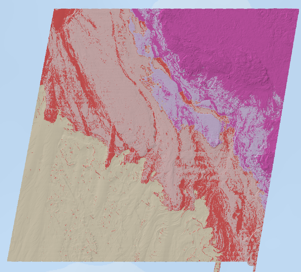
Fine-scale bathymetry mapping was conducted in the Franklin and Zeehan Australian Marine Parks (AMPs) located off the west coast of Tasmania, Australia. The primary objective of this mapping exercise was to map seafloor features of the shelf areas of these AMPs for the first time and to understand the distribution of benthic habitats and key sessile invertebrate species within these areas.
Characterisation of the seafloor was undertaken in two phases. The first stage used multibeam sonar to comprehensively map the study areas, extracting bathymetry and backscatter products. This was followed by extensive ground validation undertaken by a panoramic stereo drop-camera system that also recorded the presence of dominant sessile invertebrate fauna as well as benthic/demersal fish species.
This record describes and provides data access to the fine-scale substratum mapping extracted from the combination of multibeam bathymetry and video ground-truthing data. Access to the (1) bathymetry survey data; and (2) annotated seafloor imagery, are provided through the 'Download and Links' section of this record.
Simple
Identification info
- Date (Publication)
- 2025-07-02T00:00:00
Identifier
- Title
- Information and documentation - Digital object identifier system
- Citation identifier
- ISO 26324:2012
- Code
- 10.25959/JDWW-7M96
- Codespace
- doi.org
- Description
- Digital Object Identifier (DOI)
Principal investigator
Principal investigator
Collaborator
- Credit
- Director of National Parks (Parks Australia), Institute for Marine and Antarctic Studies
- Status
- Completed
Point of contact
Point of contact
- Topic category
-
- Geoscientific information
Extent
))
))
Temporal extent
- Time period
- 2022-02-28 2022-03-21
Vertical element
- Minimum value
- 35
- Maximum value
- 260
- Identifier
- EPSG::5715
- Name
- MSL depth
- Maintenance and update frequency
- Not planned
- Keywords (Theme)
-
- Habitat mapping
- Substrate classification
- Multibeam sonar
- Marine Parks
- BF2022_v01
- Global Change Master Directory Earth Science Keywords, Version 8.5
Resource constraints
- Linkage
-
https://licensebuttons.net/l/by/4.0/88x31.png
License Graphic
- Title
- Creative Commons Attribution 4.0 International License
- Alternate title
- CC-BY
- Edition
- 4.0
- Website
-
https://creativecommons.org/licenses/by/4.0/
License Text
- Other constraints
- Cite data as: Monk, J., Barrett, N., & Bastiaansen, A. (2023). Franklin and Zeehan Marine Park fine-scale seafloor substrate mapping [Data set]. Institute for Marine and Antarctic Studies. https://doi.org/10.25959/JDWW-7M96
- Other constraints
- Please also cite the associated project report when using this data: Barrett, Neville; Monk, Jacquomo; Bastiaansen, Ashlee (2023). Franklin and Zeehan Marine Park Multibeam mapping and drop-camera validation for Parks Australia. University of Tasmania. Report. https://doi.org/10.25959/24719955.v1
- Language
- English
- Character encoding
- UTF8
- Supplemental Information
- Barrett, Neville; Monk, Jacquomo; Bastiaansen, Ashlee (2023). Franklin and Zeehan Marine Park Multibeam mapping and drop-camera validation for Parks Australia. University of Tasmania. Report. https://doi.org/10.25959/24719955.v1
Distribution Information
- Distribution format
-
- Geotiff
- OnLine resource
- DATA ACCESS - Zeehan & Franklin Marine Parks fine-scale substrate mapping [browse files for download]
- OnLine resource
-
seamap:SeamapAus_TAS_FranklinMP_substrata_2022_grp
MAP - Franklin Marine Park substrate classification (WMS)
- OnLine resource
-
seamap:SeamapAus_TAS_ZeehanMP_substrata_2022_grp
MAP - Zeehan Marine Park fine-scale substrate mapping (WMS)
- OnLine resource
- View bathymetry data on AusSeabed
- OnLine resource
- Download bathymetry data [GA eCat record]
- OnLine resource
- View drop camera imagery on SQUIDLE+
- OnLine resource
- View drop camera deployments in map on SQUIDLE+
- OnLine resource
-
Final Project Report
Barrett, Neville; Monk, Jacquomo; Bastiaansen, Ashlee (2023). Franklin and Zeehan Marine Park Multibeam mapping and drop-camera validation for Parks Australia. University of Tasmania. Report. https://doi.org/10.25959/24719955.v1
Resource lineage
- Statement
- 𝗠𝘂𝗹𝘁𝗶𝗯𝗲𝗮𝗺 𝘀𝗼𝗻𝗮𝗿 𝗮𝗻𝗱 𝗰𝗼𝘃𝗮𝗿𝗶𝗮𝘁𝗲𝘀 Multibeam echosounder bathymetry (MBES) and backscatter were acquired by CSIRO and IMAS from the UTAS vessel Bluefin in Feb-Mar 2022. The entire Zeehan MP was mapped to the shelf break, overlapping prior CSIRO mapping of the upper slope and shelf crest. Approximately 50% of the Franklin MP was mapped before bad weather prevented completion of the survey. Bathymetry data was processed by at 2 metre resolution. 𝗔𝘂𝘁𝗼𝗺𝗮𝘁𝗲𝗱 𝗲𝘅𝘁𝗿𝗮𝗰𝘁𝗶𝗼𝗻 𝗼𝗳 𝘀𝘂𝗯𝘀𝘁𝗿𝗮𝘁𝗲 𝗰𝗹𝗮𝘀𝘀𝗲𝘀 Habitat models were developed using terrain and backscatter variables derived from the MBES data. The ArcGIS packages ‘Spatial Analyst' and ‘Benthic Terrain Modeller’, and R ‘WhiteBoxTools’ were used. 𝗗𝗿𝗼𝗽 𝗰𝗮𝗺𝗲𝗿𝗮 𝘃𝗮𝗹𝗶𝗱𝗮𝘁𝗶𝗼𝗻 For validation of the automated substrata classification, ~300 spatially balanced drop camera deployments (BOSS) were deployed per park, focusing on high-relief areas. A five-camera system (four oblique, one vertical) recorded 5-minute videos at each site using GoPro Hero 9 cameras to allow for observations of associated benthic/demersal fish. Still frames were annotated using 20-point overlays in the lower frame, applying the CATAMI scheme. Substrate types were grouped into three Seamap Australia (https://vocabs.ardc.edu.au/viewById/129) substratum classes: (1) Hard – 100% consolidated reef (2) Mixed – combination of hard and soft (3) Soft – unconsolidated sediment without visible epibenthos 𝗦𝘂𝗯𝘀𝘁𝗿𝗮𝘁𝗲 𝗺𝗼𝗱𝗲𝗹𝗹𝗶𝗻𝗴 Random Forest models were implemented in R (RandomForest package), using 60:40 training:test data splits. • Franklin MP: 1000 trees, 10-node size, max 5 features/split • Zeehan MP: 4 trees, 10-node size, max 1 feature/split Model accuracy was assessed using 10-fold cross-validation: • Franklin MP: 71% overall accuracy, kappa = 0.55 • Zeehan MP: 71% overall accuracy, kappa = 0.47 𝗙𝗶𝗻𝗮𝗹 𝗱𝗮𝘁𝗮 𝗽𝗿𝗲𝗽𝗮𝗿𝗮𝘁𝗶𝗼𝗻 For publication, depth thresholds of 30-70 m and 70-200 m were then applied to the model to split reef habitats into mesophotic and rariphotic reefs, respectively, following Parks Australia’s Natural Value Ecosystems classification (Hayes et al. 2021).
- Hierarchy level
- Dataset
- Hierarchy level
- Dataset
Platform
Identifier
- Code
- Maxar's WorldView-2/3
Instrument
Identifier
- Code
- Multispectral Satellite Sensor
Metadata
- Metadata identifier
- urn:uuid/6eb8ab22-6ba4-4c5a-8454-73e279f751f0
- Language
- English
- Character encoding
- UTF8
Distributor
- Parent metadata
Type of resource
- Resource scope
- Dataset
- Name
- IMAS Dataset level record
- Metadata linkage
-
https://metadata.imas.utas.edu.au/geonetwork/srv/eng/catalog.search#/metadata/6eb8ab22-6ba4-4c5a-8454-73e279f751f0
Point of truth URL of this metadata record
- Date info (Creation)
- 2023-06-30T00:00:00
- Date info (Revision)
- 2026-04-27T15:26:13
Metadata standard
- Title
- ISO 19115-3:2018
Overviews
Spatial extent
Provided by
