 IMAS Metadata Catalogue
ANIMAL ECOLOGY AND BEHAVIOR
Type of resources
Topics
Keywords
Contact for the resource
Provided by
Years
-
This Classification Catalog shows example images for all biotic labels used in developing the Antarctic Seafloor Annotated Imagery Database (AS-AID). This catalog represents a snapshot of the database at the time of publication of the associated data-paper. The labels used are based on the Australian Morphospecies Catalog, which is an extension of the CATAMI classification scheme. All underlying data are publicly available on Squidle+ (https://squidle.org). Up to 16 randomly selected images are presented for each classification, alongside a table with the following information: • Found in campaigns: a list of all campaigns in AS-AID in which this organism has been detected • Total annotations: the total number of annotations for this label • VME-taxa: whether this label is identified as a CCAMLR Vulnerable Marine Ecosystem taxa
-
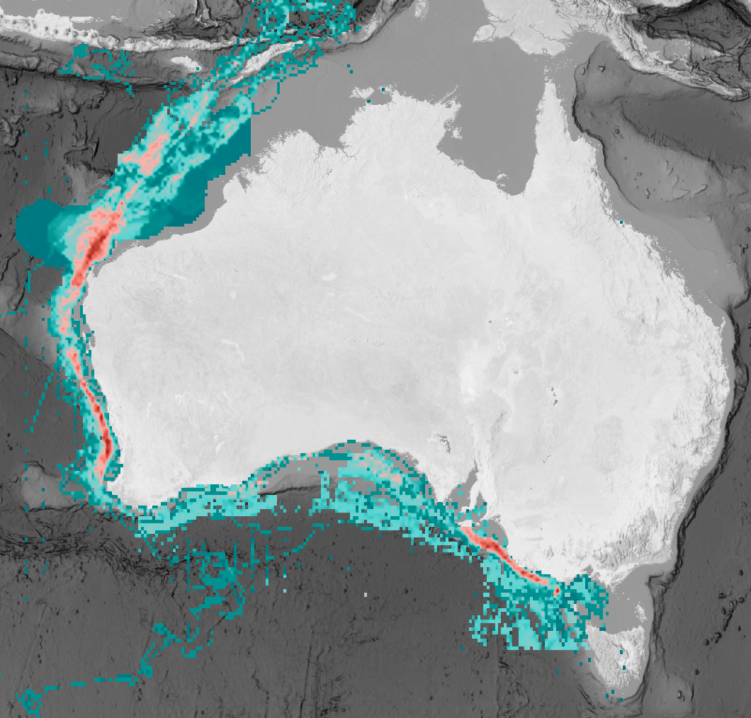
The offshore renewable energy (ORE) sector is rapidly developing in Australian waters to support national carbon emission targets. However, new marine infrastructure can introduce additional risks to threatened species. The eastern Indian Ocean pygmy blue whale (Balaenoptera musculus brevicauda) was identified by the Australian Government as a priority species for assessing potential ORE impacts. This subspecies ranges from the Subtropical Convergence (~40-45°S) to Southeast Asia (~2°S), with much of its documented distribution occurring within Australia’s Exclusive Economic Zone. Its distribution overlaps with multiple anthropogenic activities, indicating likely exposure to existing and emerging pressures. This dataset compiled available spatial information to quantify the full distribution and foraging distribution of pygmy blue whales, and to assess exposure to individual and cumulative threats across the species’ range. The threat exposure analysis incorporated expert elicitation to estimate the probability of exposure arising from spatial overlap between pygmy blue whale distribution and anthropogenic pressures, with particular focus on areas undergoing ORE development. The cumulative exposure assessment indicated relatively low exposure of pygmy blue whales to existing threats within Australian waters, including within declared ORE areas. However, several data and knowledge gaps were identified that should be addressed before further ORE development. The resulting spatial layers provide a baseline for impact assessment by industry and regulators, and support decision-making for sustainable ORE development in Australian waters.
-
The data here presented shows the relationship between sea urchin numbers and algal cover in the Western Mediterranean. Data was collected in several underwater surveys using subdivided quadrats. The grazing effect of urchins on the macroalgal community was evaluated.
-
This data is from experiments conducted at IMAS Taroona laboratories on predation of urchins by the Southern Rock Lobster. Four experiment types were conducted, including live urchins, urchin roe and trimmed urchins. This data directly supports the publication https://doi.org/10.1071/MF23140
-
Adult and sub-adult Red handfish (Thymichthys politus) and Spotted handfish (Brachionichthys hirsutus) preserved specimens and underwater images were used for analysing morphometrics (comprising of specimens from the CSIRO Australian National Fish Collection and underwater images). Individuals were measured for the morphological traits using electronic callipers (±0.1 mm) for preserved specimens and using Image J software for digital records. Note digital image size calibration occurred using a ruler in images or from size taken in situ. The purpose was to investigate whether external morphometrics could be used to determine sex in handfishes.
-
This dataset contains image annotations for 21 Antarctic research campaigns between 1985 and 2019, recorded as part of the Antarctic Seafloor Annotated Imagery Database (AS-AID). This snapshot of the AS-AID annotations comprises of a total of 632,252 expert annotations. Annotations are based on the Collaborative and Automated Tools for Analysis of Marine Imagery (CATAMI) classification scheme and have been reviewed by experts. Three annotation sets exist for each campaign: point grid annotations of 108 points per image, bounding box annotations for mobile fauna, and bounding box annotations for select benthic species which are classified as Vulnerable Marine Ecosystem species. All annotations are also accessible through Squidle+ by following this persistent link: https://squidle.org/geodata/explore/map?filters=%7B%22platform_ids%22%3A%5B%2222%22%5D%7D This dataset can be used to investigate species distributions, community patterns, provide a reference to assess change through time, and can be used to train algorithms to automatically detect and annotate marine fauna.
-
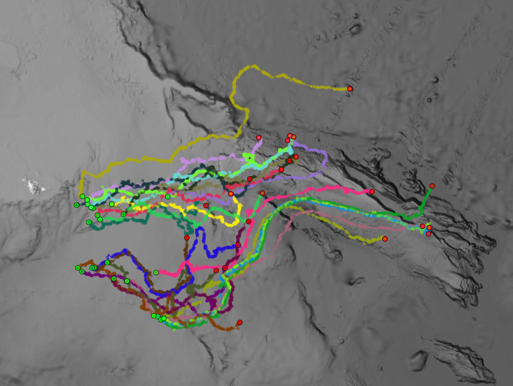
This record provides an overview of the NESP Marine and Coastal Hub project "Mapping critical Australian sea lion habitat to assess ecological value and risks to population recovery". For specific data outputs from this project, please see child records associated with this metadata. -------------------- Australian sea lion populations have declined by more than 60% over the past four decades. Abundance and trends vary markedly across the species range, suggesting that localised risk profiles from threats - such as bycatch, marine pollution, and habitat degradation - vary at small spatial scales. Fine scale variation in habitat use is thought to underpin these differences, yet knowledge about Australian sea lion's dependency on key habitats and their vulnerability to human impacts is limited. This project deployed compact animal-borne cameras with GPS and motion sensors on eight adult female sea lions at two key colonies: Seal Bay (Southern Kangaroo Island Marine Park) and Olive Island (Western Eyre Marine Park). The devices recorded nearly 80 hours of footage over 560 km of seabed, identifying six distinct benthic habitat types, including previously unmapped rocky reefs and kelp forests. The footage was used to develop fine-scale habitat maps using machine learning models, providing a valuable baseline for assessing ecological value, foraging intensity, and the effectiveness of protected areas. This innovative approach complements traditional seafloor mapping and offers a scalable, cost-effective method for locating and monitoring critical habitats for endangered marine species. The results directly inform recovery planning, fisheries management, marine park design, and the identification of Biologically Important Areas. Ongoing camera deployments at Seal Bay and new sites along the western Eyre Peninsula will improve understanding of sea lion colony-specific behaviours and contribute to long-term monitoring of habitat change, diet, and emerging threats. Outputs • Tracking data from sea lion-deployed tags: location, depth, time, temperature, light, acceleration [dataset] • Timestamped video footage from sea lion-deployed cameras [dataset] • Final project report [written]
-
This dataset contains stable isotope and tracking data from adult female Antarctic fur seal collected at three breeding colonies across the Southern Ocean: • Marion Island (2008–2018) • Bird Island, South Georgia (2008–2012) • Cape Shirreff, South Shetland Islands (2008–2012) The dataset includes: • Stable isotope data from whole blood and whiskers • Compound-specific amino acid isotope data (δ¹⁵NAA) from whole blood • GLS-derived tracking and environmental data Samples were collected from adult female seals captured between February and April prior to winter migration. Whole blood samples provide dietary information integrated over approximately 2–3 months, while sequential whisker sections provide longer-term isotopic records spanning multiple years. Bulk stable isotope values (δ¹³C and δ¹⁵N) and compound-specific isotope analysis of amino acids (CSIA-AA) provide information on trophic ecology and foraging habitat across multiple temporal scales, from recent feeding behaviour to multi-year dietary histories recorded in whiskers. The dataset also includes light-based geolocation (GLS) tracking data from adult females equipped with geolocator loggers during the inter-breeding migration period. Tracking variables include timestamps (GMT), estimated geographic positions (latitude and longitude), uncertainty metrics, and associated environmental variables such as sea surface temperature (SST) and absolute dynamic topography (ADT), where available.
-
Biotelemetry devices, including satellite transmitters and archival Global Positioning System (GPS) loggers, were deployed on shy albatrosses, short-tailed shearwaters, and both Australian and long-nosed fur seals. Tags were deployed during the breeding season to maximise data on foraging behaviour and habitat use. This record currently contains tracking data from breeding adult shy albatross (Thalassarche cauta). Additional tracking data from migratory short-tailed shearwater (Ardenna tenuirostris), the endemic Australian fur seal (Arctocephalus pusillus doriferus), and long-nosed fur seal (Arctocephalus forsteri) will be added at a later date. The shy albatross collection includes raw tracking data, and filtered processed tracks fitted with a state space model (Jonsen et al., 2023). These data include the following variables: birdID, breeding phase, tracker type, date/time, locations in latitude and longitude (for both the raw and fitted), and uncertainty metrics. ***EMBARGO NOTE*** Data is currently embargoed - to be released late 2026.
-
Time series dataset of depth and activity recorded by miniPAT (Wildlife computers) popup satellite archival tags deployed on Kerguelen sandpaper skates (Bathyraja irrasa, n=24) caught in the Patagonian toothfish longline fishery in Heard Island and McDonald Islands. Tags were deployed to assess the post-release survival of skates in the fishery.