 IMAS Metadata Catalogue
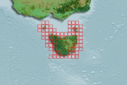
TASMANIA
Type of resources
Topics
Keywords
Contact for the resource
Provided by
Years
-
This seagrass habitat map was produced by the ACEAS Seagrass working group as part of the seagrass habitat risk modelling effort. The map identified seagrass presence based on 1) on the NISB (National Intertidal-Subtidal Benthic) Habitat Map created by the University of Tasmania for a partnership between the Department of Climate Change and the National Land and Water Resources Audit, 2) UNEP WCMC Seagrass map 2005
-
This GIS layer is the product of interpreted multibeam acoustic data charaterising the distribution pattern of seafloor habitats at forty sampling sites within the Flinders Commonwealth Marine Reserve. The three classes that were mapped include hard, mixed and soft substrate. Mappin the Flinders CMR is a prerequisite to understanding the relationships between inshore (shelf) and offshore (slope) habitats and therefore representing a key element in developing effective management for the depth strata across the entire CMR. Habitat characterisation provides the underlying spatial framework for developing models of habitat dynamics, trophic interactions and spatial distribution of marine biodiversity.
-

Describes the database used for storing Southern Rock Lobster (Jasus edwardsii) biological data collected by observers on commercial boats and dedicated research trips incorporating information on sex, length, weight, damage, reproduction, bycatch, protected species interaction, location, depth, tagging and equipment type.
-
To test if the carapace length of lobsters changes during cooking, 21 legal-sized southern rock lobsters were collected in pots from Alum Cliffs, south-eastern Tasmania, Australia in October 1999 (42.95±S 147.35±E). The sample consisted of 7 female and 14 male lobsters ranging in carapace length from 106 mm to 153 mm (mean 120 mm). Each animal was abdominally tagged using individually marked t-bar tags (Hallprint T-bar anchor tag, TBA1; Hallprint Pty Ltd, 27 Jacobsen Crescent, Holden Hill, SA 5088, Australia). The carapace length of all lobsters were measured five times to the nearest 0.1 mm in a random manner, before and after processing. This repeated measurement of all specimens in random order was intended to evaluate measurement error. Processing was typical of that used commercially and involved killing the lobsters in fresh water before cooking in pre-boiling salted water for 12 minutes.
-
Southern Rock Lobster (Jasus edwardsii) biological data collected by observers on commercial boats and dedicated research trips incorporating information on sex, length, weight, damage, reproduction, bycatch, protected species interaction, location, depth, tagging and equipment type.
-
Inter-moult duration in giant crabs (Pseudocarcinus gigas) was estimated by an alternative method to utilising tag-recovery data. Reproduction in female giant crabs occurs in annual cycles, although females occasionally “skip” a reproductive season and do not become ovigerous; it has been noted previously that this appears to be associated with molting. Thus the proportion of females that do not participate in reproduction may indicate the proportion molting. This approach was tried with a sample of 342 females and the number that were “skipping” a reproductive season was measured by computerized tomography scanning (CT-scanning) of their ovaries prior to the extrusion of eggs. Radiometric aging (228Th/ 228Ra) of carapaces was also undertaken with the focus of this work on testing an assumption of the method, rather than describing the intermolt duration of a population.
-
These data describe quantitative exposure indices generated using cartographic fetch methods on a 0.01 degree grid across temperate Australia (South Australia, Victoria and Tasmania). Two indices are reported: openness and bathymetry-altered fetch. Openness is a measure of the distance of a site to the nearest coastline in all directions and describes potential exposure to locally generated seas and undefined swell. Bathymetry-altered fetch attempts to account for the attenuation of wave energy as waves move into shallow waters and encounter friction with the seafloor.
-
The data is the quantitative abundance of fish derived from underwater visual census methods involving transect counts at rocky reef sites around Tasmania. This data forms part of a larger dataset that also surveyed megafaunal invertebrate abundance and algal cover for the area. The aggregated dataset allows examination of changes in Tasmanian shallow reef floral and faunal communities over a decadal scale - initial surveys were conducted in 1992-1995, and again at the same sites in 2006-2007. There are plans for ongoing surveys. An additional component was added in the latter study - a boat ramp study looking at the proximity of boat ramps and their effects of fishing. We analysed underwater visual census data on fishes and macroinvertebrates (abalone and rock lobsters) at 133 shallow rocky reef sites around Tasmania that ranged from 0.6 - 131 km from the nearest boat ramp. These sites were not all the same as those used for the comparison of 1994 and 2006 reef communities. The subset of 133 sites examined in this component consisted of only those sites that were characterized by the two major algal (kelp) types (laminarian or fucoid dominated). Sites with atypical algal assemblages were omitted from the 196 sites surveyed in 2006. This study aimed to examine reef community data for changes at the community level, changes in species richness and introduced species populations, and changes that may have resulted from ocean warming and fishing. The methods are described in detail in Edgar and Barrett (1997). Primarily the data are derived from transects at 5 m depth and/or 10 m depth at each site surveyed. The underwater visual census (UVC) methodology used to survey rocky reef communities was designed to maximise detection of (i) changes in population numbers and size-structure (ii) cascading ecosystem effects associated with disturbances such as fishing, (iii) long term change and variability in reef assemblages.
-
We have used a quantitative definition of marine heatwaves to detect all events which have occurred in 12 regions across the continental shelf off eastern Tasmania over 1993-2015. For each event in each region this atlas includes information on (i) event properties including intensity, duration and depth, (ii) maps of regional ocean circulation and ocean temperature during the event, and (iii) maps of regional atmospheric conditions during the event (air temperature and surface wind). Also provided are summary statistics including the typical conditions which give rise to marine heatwaves in each region and annual time series demonstrating interannual variability and long term trends in marine heatwave properties. Provided is a comprehensive document presenting the atlas and a set of CSV files containing the underlying data.