 IMAS Metadata Catalogue
Concentration of oxygen {O2} per unit volume of the water body
Type of resources
Topics
Keywords
Contact for the resource
Provided by
Years
-
This atlas uses all of the available full water column profiles of oxygen, salinity and temperature available as part of the World Ocean Atlas released in 2018. Instead of optimal interpolation we use the Data Interpolating Variational Analysis (DIVA) approach to map the available profiles onto 108 depth levels between the surface and 6800 m, covering more than 99% of ocean volume. This 1/2° x 1/2° degree atlas covers the period 1955 to 2018 in 1 year intervals. The DIVA method has significant benefits over traditional optimal interpolation. It allows the explicit inclusion of advection and boundary constraints thus offering improvements in the representations of oxygen, salinity and temperature in regions of strong flow and near coastal boundaries. We demonstrate these benefits of this mapping approach with some examples from this atlas. We can explore the regional and temporal variations of oxygen in the global oceans. Preliminary analyses confirm earlier analyses that the oxygen minimum zone in the eastern Pacific Ocean has expanded and intensified. Oxygen inventory changes between 1970 and 2010 are assessed and compared against prior studies. We find that the full ocean oxygen inventory decreased by 0.84% ± 0.42%. For this period temperature driven solubility changes explain about 21% of the oxygen decline over the full water column, in the upper 100 m solubility changes can explain all of the oxygen decrease, for the 100-600 m depth range it can explain only 29%, 19% between 600 m and 1000 m, and just 11% in the deep ocean.
-
Conducted under the Coast and Clean Seas program of the Natural Heritage Trust fund, this study provides a summary and assessment of water quality parameters, as indicators of estuarine health, in 22 selected Tasmanian estuaries. The estuaries are: Duck Bay, East Inlet, Black River, Don River, Mersey River, Port Sorell, Boobyalla Inlet, Little Musselroe River, Ansons Bay, Grants Lagoon, Douglas River, Great Swanport, Meredith River, Little Swanport, Earlham Lagoon, Browns River, Cloudy Bay Lagoon, Catamaran River, Cockle Creek, Pieman River, Nelson Bay River and Arthur River (for location, see Fig. 1 in the attached report). Information is summarised on both a State wide and individual estuary basis.
-
-- Layton et al. Chemical microenvironments within macroalgal assemblages: implications for the inhibition of kelp recruitment by turf algae. Limnology & Oceanography. DOI:10.1002/lno.11138 -- Kelp forests around the world are under increasing pressure from anthropogenic stressors. A widespread consequence is that in many places, complex and highly productive kelp habitats have been replaced by structurally simple and less productive turf algae habitats. Turf algae habitats resist re-establishment of kelp via recruitment inhibition; however little is known about the specific mechanisms involved. One potential factor is the chemical environment within the turf algae and into which kelp propagules settle and develop. Using laboratory trials, we illustrate that the chemical microenvironment (O2 concentration and pH) 0.0–50 mm above the benthos within four multispecies macroalgal assemblages (including a turf-sediment assemblage and an Ecklonia radiata kelp-dominated assemblage) are characterised by elevated O2 and pH relative to the surrounding seawater. Notably however, O2 and pH were significantly higher within turf-sediment assemblages than in kelp-dominated assemblages, and at levels that have previously been demonstrated to impair the photosynthetic or physiological capacity of kelp propagules. Field observations of the experimental assemblages confirmed that recruitment of kelp was significantly lower into treatments with dense turf algae than in the kelp-dominated assemblages. We demonstrate differences between the chemical microenvironments of kelp and turf algae assemblages that correlate with differences in kelp recruitment, highlighting how degradation of kelp habitats might result in the persistence of turf algae habitats and the localised absence of kelp.
-
A 12-month program was developed and implemented in order to obtain baseline information on water quality (salinity, water temperature, dissolved oxygen, turbidity, pH, dissolved nutrients, silica), ecological condition as shown by Chlorophyll a, benthic macroinvertebrates, pathogens, and habitat extent determined from habitat mapping. Five key estuaries and coastal waters were assessed in the Southern NRM Region of Tasmania. This data includes sampling from Pitt Water / Orielton Lagoon, North West Bay, Port Cygnet, Little Swanport, Moulting Lagoon / Great Swanport.
-
Water quality and biological data was collected from four tide-dominated river estuaries indicative of catchments with varying levels of human impacts to: 1) assess draft indicator levels for water quality, and 2) investigate biological indicators of estuarine health in NW Tasmania. This data includes sampling from Detention River, Duck Bay, Montagu River and Black River
-
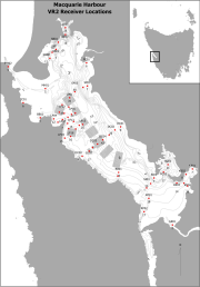
Fixed position oxygen and water temperature logger data from the Macquarie Harbour World Heritage Area (WHA). Two Hobo oxygen data loggers are positioned at approximately 15 m depth at different sites within the WHA, with the intent of monitoring representative mid-bottom water oxygen values in the WHA as these were identified in previous studies to be naturally low due to limited seawater exchange at the harbour entrance, and thus likely to be most susceptible to anthropogenic factors that may increase oxygen demand and alter WHA conservation values. These values include core habitat of the Maugean Skate, a listed threatened species. This work is funded by WHA advisory board via the Nature Conservation Branch of DPIPWE and is part of a larger study being conducted by IMAS undertaking a biological baseline study of the biodiversity of the Macquarie Harbour WHA. This data spans 08/11/14 to present (most recent update 02/02/17).
-
Water temperature, averaged across the water column, in Storm Bay followed a distinct seasonal cycle each year, reaching a low of 9 °C and a high of ~ 19 °C. Warmest temperatures were in February, followed by a gradual cooling throughout autumn to a winter minimum in August, then increasing again during spring. Across the sites, the median temperature varied little, with site 3, the most marine of the sites, showing the least spread in values. Median salinity varied little across Storm Bay, being slightly higher at sites 3 and 6, highlighting the marine nature of site 3 and the patterns of seawater circulation in Storm Bay. The lowest salinities were recorded at site 1, where less saline surface waters flow into the bay from the Derwent Estuary. Seasonally, salinity was highest in autumn, with slightly fresher water present in Storm Bay in spring. Some lower salinity values were recorded in July and August, suggesting the presence of less saline subantarctic water flowing into the bay, or freshwater flow from the Derwent. Glider transects show slight lower salinity in summer, then mild stratification in autumn to spring, especially in the shallow regions near the mouth of the Derwent.