 IMAS Metadata Catalogue
The University of Queensland
Type of resources
Topics
Keywords
Contact for the resource
Provided by
Years
-
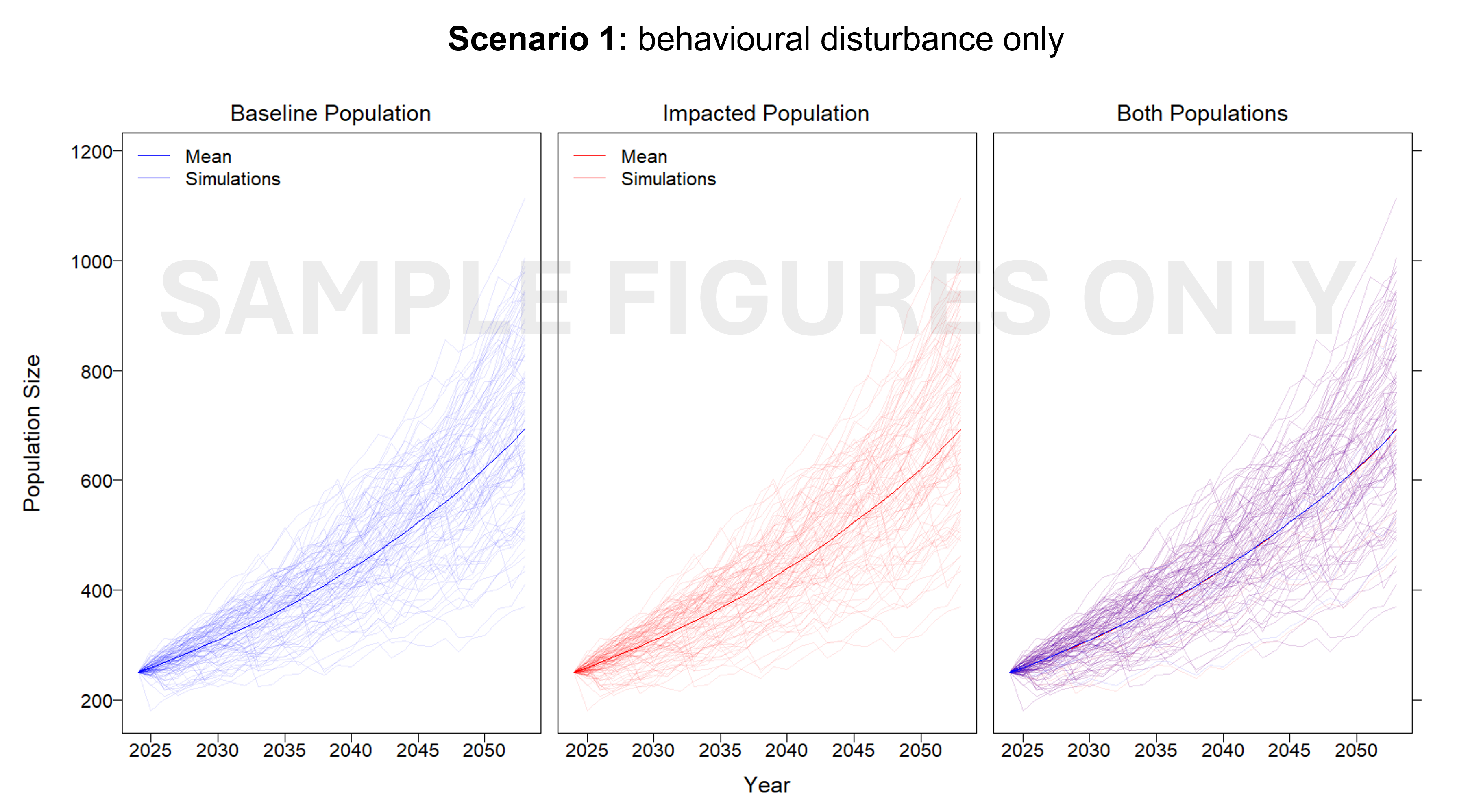
This project developed an interim Population Consequence of Disturbance (iPCoD) model for blue whales (Balaenoptera musculus) and southern right whales (Eubalaena australis) to document a methodology for assessing population-level impacts of one, or multiple, wind farm developments off the southern Australian coast. The iPCoD model was developed in Europe to quantify how disturbances of individuals caused by physiological injury or changes in behaviour can have population-level consequences in data poor marine mammal populations. This model was adapted to suit Australian marine mammal species, highlighting key data gaps for locally threatened populations that overlap in range with the declared offshore wind areas in Australia. Due to the lack of baseline data currently available, this study documented a framework that can be updated as more information becomes available. We outlined how to leverage simulation-based population modelling as a tool for policymakers, industry and management authorities, to aid in environmental impact assessments, with a specific focus on data poor marine mammal populations.
-
This record provides an overview of the NESP Marine and Coastal Hub small-scale study - "Australia’s Coastal Shorebirds: Trends and Prospects". No data outputs were generated by this project. -------------------- Coastal Australia is home to 37 regularly occurring migratory shorebird species, with many protected areas including Ramsar sites designated on the basis of shorebird populations. Many migratory shorebirds are declining rapidly, and hence the focus of conservation efforts at multiple levels of government in Australia and overseas. However, trend data are now nearly 10 years old, meaning the information available to assess where conservation actions are needed most urgently and whether conservation efforts are helping species recover are outdated. To ensure populations have the best chance at recovery and that resources are allocated where they are most likely to have the greatest positive impacts, it is critical to maintain up-to-date information on species trends. This project analysed 30 years of shorebird monitoring data collected by citizen science groups across Australia and curated by BirdLife Australia’s National Shorebird Monitoring Program to update national trend estimates, while also assessing the relative effects of human pressure and conservation efforts on population trends. In particular, it focused on 15 migratory shorebird species whose conservation status was being reassessed by the Australian Department of Climate Change, Energy, the Environment and Water. This project sets the stage for building the next decade of coastal shorebird conservation activity in Australia, coordinated through the national mechanism of the End User: National Migratory Shorebird Conservation Action Plan Steering Committee, with representatives from national and state governments as well as leading shorebird experts. Outputs • Fact Sheet on Australia's coastal shorebird trends and prospects [written] • Final Project Report, including a short summary of recommendations for policy makers of key findings [written]
-
This record provides an overview of the NESP Marine and Coastal Hub Research Plan 2024 project "Assessing the vulnerability of southern right whale and blue whale populations to disturbance from windfarm developments". For specific data outputs from this project, please see child records associated with this metadata. -------------------- Offshore renewable energy (ORE) development is expanding in Australian waters. This includes regions that overlap with feeding and breeding areas for Endangered blue whales and southern right whales. Underwater noise from construction and operation of offshore wind infrastructure may affect whale behaviour, energetics and reproduction, requiring assessment of potential population-level consequences under the EPBC Act. This desktop study used available data and expert elicitation to develop interim Population Consequences of Disturbance (iPCoD) models for blue whales and southern right whales in relation to one or multiple offshore wind developments off Portland and Gippsland, Victoria. The modelling followed a decision pathway that considered spatial and temporal overlap with whale populations, the proportion of populations affected, life stages and reproductive phases exposed, and the likelihood of repeated disturbance. The models were used to assess the timing, location and potential cumulative effects of underwater noise at a regional scale. Outputs identified high-risk species and scenarios, priority data gaps, research needs, and mitigation requirements needed to reduce the likelihood of compromised population viability. The iPCoD framework can be updated as new data become available and integrated with other modelling approaches. The framework is relevant for risk assessment against other ocean-based activities such as seismic surveys oil and gas infrastructure, and carbon capture and storage. The project outputs support offshore wind assessment and regulation, species recovery planning, and development of underwater noise guidance. Outputs • iPCoD model outputs [dataset] • Final Project Report [written]
-
This record provides an overview of the NESP Marine and Coastal Hub small-scale study - "OzSET: Integration and publication of the Australian Surface Elevation Table dataset". For specific data outputs from this project, please see child records associated with this metadata. -------------------- Australia’s coastal floodplains and wetlands provide essential ecosystem services and have immense cultural value. They regulate water quality, moderate flood and storm damage, and provide habitat for marine life including commercial fish and shellfish species. These environments are threatened by accelerating rates of sea-level rise. A national approach is needed to monitor and assess the way coastal floodplains and wetlands are changing in response to sea level rise. A useful measure of resilience is the extent to which coastal wetland sediments can accrete vertically at a rate matching that of sea-level rise. Assessing the resilience, or vulnerability, of these environments requires measurements of rates of vertical accretion, subsidence and elevation gain across a range of coastal settings. The Surface Elevation Table-Marker Horizon (SET-MH) technique measures the vertical accretion of coastal wetland sediments. This enables assessment of whether wetlands are keeping pace with sea level rise (measured at tide gauges), or subsiding relative to local sea level rise and thus vulnerable to permanent inundation and loss. Australia’s network of Surface Elevation Tables is one of the most extensive in the world, consisting of over 200 benchmark monitoring stations from Westernport Bay, Victoria to Darwin Harbour, NT. The network has developed largely without national coordination, and the data gathered have not been readily available to the research community or research users. This project collated SET data on accretion, subsidence and elevation change in mangroves, saltmarshes, seagrasses and tidal freshwater forests, and provides an initial analysis of accretion and surface elevation trends. This information is vital to coastal risk assessment, estimating blue carbon sequestration, and modelling potential predicted changes in other ecosystem services. Outputs • Collation of data from existing Surface Elevation Table (SET-MH) stations [dataset] • Final Technical Report