 IMAS Metadata Catalogue
Parks Australia
Type of resources
Topics
Keywords
Contact for the resource
Provided by
Years
-
An assessment was made of the state of research knowledge in the Australian Marine Parks (2022 boundaries). This quality assessment is specifically of the suitability of data streams for deriving habitat maps. Five nationally-aggregated data streams were used in the assessment: (1) Seamap Australia (seafloor habitat) (2) AusSeabed bathymetry survey extents (bathymetry mapping) (3) Squidle+ imagery deployments (habitat observations) (4) GlobalArchive video deployments (habitat observations) (5) Geoscience Australia's Marine Sediment Database (MARS) From these data streams, quality ratings (0-5) have been made for the state of research knowledge for three research disciplines: (A) bathymetry maps; (B) habitat observations; and (C) habitat maps. Data quality assessments are reported for each AMP Network and Park. Assessments can be accessed in context at https://seamapaustralia.org/region-reports, via the State-of-Knowledge functionality in the Seamap Australia mapping portal: https://seamapaustralia.org/map, or as a stand-alone file in the 'Downloads' section of this record. This data is live and is refreshed weekly.
-
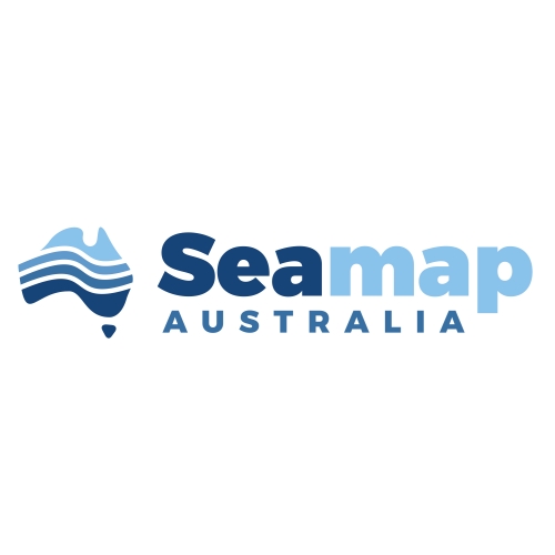
The imagery provides representative and highlight clips from the quantitative sampling of the abundance, body size and diversity of demersal fishes baited remote underwater stereo video (stereo BRUV) in and around Tasman Fracture, Beagle, Huon and Freycinet Australian Marine Parks (AMPs). The dataset allows examination of changes in fish communities over time as part of ongoing monitoring of these AMPs. There are plans for ongoing surveys as part of Parks Australia's management of the AMPs. The methods and key findings of the work are described in detail in Monk et al. (2016) and Perkins et al. (2022).
-
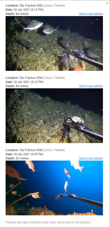
This data is a national compilation of video clips predominantly derived from underwater video sampling techniques (e.g. BRUV, Stereo-BOSS) for quantitative sampling of abundance, body size, and diversity of demersal fishes. The curated collection also includes regional 'compilation' videos highlighting a particular marine protected area or region of interest. Current contributors to this data compilation are IMAS, UWA, Geoscience Australia and the NESP Marine Biodiversity & Marine and Coastal Hubs, with the intention that this collection will grow to encompass collections from other research organisations around Australia. As of August 2024, this dataset includes video in and around Abrolhos, Arafura, Apollo, Beagle, Bremer, Christmas Island, Cod Grounds, Coral Sea, Dampier, Eastern Recherche, Flinders, Franklin, Freycinet, Gascoyne, Geographe, Huon, Lord Howe, Montebello, Murat, Murray, Ningaloo, Oceanic Shoals, Perth Canyon, South Tasman Rise, South-west Corner, Tasman Fracture, Two Rocks, and Zeehan Australian Marine Parks (AMPs), and of Bathurst Channel in the Port Davey Marine Reserve. The dataset allows examination of changes in fish communities over time as part of ongoing monitoring of these regions. This record represents a 'parent' record of multiple collections. See individual 'child' records for more information on specific regional collections.