 IMAS Metadata Catalogue
Management Effectiveness (ME)
Type of resources
Topics
Keywords
Contact for the resource
Provided by
Years
-

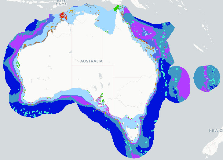
The Parks Australia Management Effectiveness (ME) system - previously MERI - is underpinned by a controlled, common language that provides a nationally consistent lexicon for a) Natural, cultural, and heritage values; (b) Social, cultural, and economic benefits; (c) Activities and anthropogenic pressures; and (d) Biophysical, and social and economic drivers. The Natural Values component of the common language is defined at three levels: 1) ecosystem complexes; 2) ecosystems; and 3) ecosystem components. This map shows the Ecosystems (tier 2) component of the Natural Values, and delineates features by habitat and depth for the Australian Exclusive Economic Zone (EEZ). This version (2026) of the National Values Ecosystems dataset uses Geoscience Australia's 250m resolution AusBathyTopo 2024 grid as the basis for the map. The dataset is currently in draft format and may be updated at any time. The 2026 update incorporates revised and improved input datasets that have become available since the previous release. Several classification rules were updated to align with these inputs, including the use of Seamap Australia National Benthic Habitat Layer data as the primary source for mapped seagrass and coral reef occurrence. Note that this dataset uses a combination of input data sources and interpolates where data gaps exist. The common language adopts a functional, largely geo-physical perspective to define surrogates for marine ecosystems. This dataset is not a substitute for a validated habitat map (see Seamap Australia National Benthic Habitat Layer: https://metadata.imas.utas.edu.au/geonetwork/srv/eng/catalog.search#/metadata/4739e4b0-4dba-4ec5-b658-02c09f27ab9a), but has a national coverage and provides valuable broad-scale categorisation of marine ecosystems in Australian waters. See Hayes et al. 2021 and Dunstan et al. 2023 for a full definition of the Natural Values Ecosystem terms. See the 'lineage' section of this record for full processing notes.
-
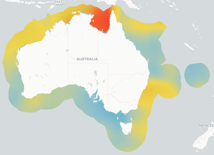
The Parks Australia Management Effectiveness (ME) system - previously MERI - is underpinned by a controlled, common language that provides a nationally consistent lexicon for a) Natural, cultural, and heritage values; (b) Social, cultural, and economic benefits; (c) Activities and anthropogenic pressures; and (d) Biophysical, and social and economic drivers. The Natural Values component of the common language is defined at three levels: 1) ecosystem complexes; 2) ecosystems; and 3) ecosystem components. This map shows the Ecosystems (tier 2) component of the Natural Values, and delineates features by habitat and depth for the Australian Exclusive Economic Zone (EEZ). This version (2022) of the National Values Ecosystems dataset uses Geoscience Australia's 250m resolution Australian Bathymetry and Topography Grid, 2009 (https://dx.doi.org/10.4225/25/53D99B6581B9A) as the basis for the map. See Hayes et al. 2021 and Dunstan et al. 2023 for a full definition of Natural Values Ecosystem terms, input datasets used, and processing steps involved with the creation of this map. Note that this dataset uses a combination of input data sources and interpolates where data gaps exist. The common language adopts a functional, largely geo-physical perspective to define surrogates for marine ecosystems. This dataset is not a substitute for a validated habitat map (see Seamap Australia National Benthic Habitat Layer: https://metadata.imas.utas.edu.au/geonetwork/srv/eng/catalog.search#/metadata/4739e4b0-4dba-4ec5-b658-02c09f27ab9a), but has a national coverage and provides valuable broad-scale categorisation of marine ecosystems in Australian waters. ***An updated version of this data product is available - see https://doi.org/10.25959/7SXA-DX47***
-
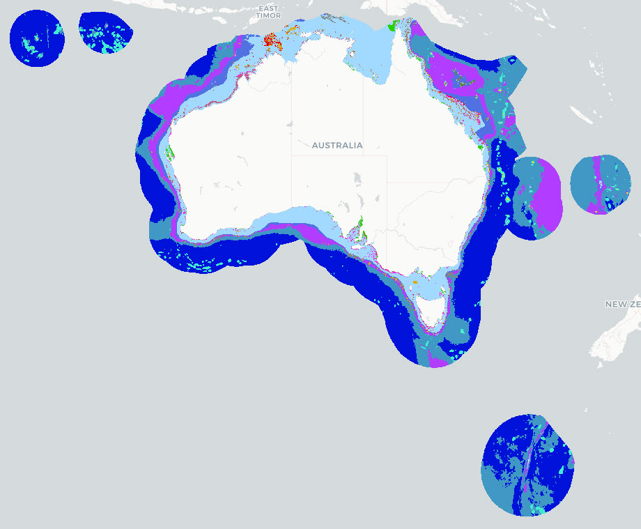
The Parks Australia Management Effectiveness (ME) system - previously MERI - is underpinned by a controlled, common language that provides a nationally consistent lexicon for a) Natural, cultural, and heritage values; (b) Social, cultural, and economic benefits; (c) Activities and anthropogenic pressures; and (d) Biophysical, and social and economic drivers. The Natural Values component of the common language is defined at three levels: 1) ecosystem complexes; 2) ecosystems; and 3) ecosystem components. This map shows the Ecosystems (tier 2) component of the Natural Values, and delineates features by habitat and depth for the Australian Exclusive Economic Zone (EEZ). This version (2025) of the National Values Ecosystems dataset uses Geoscience Australia's 250m resolution AusBathyTopo 2024 grid as the basis for the map. The dataset is an interim product between the 2022 version (https://doi.org/10.25959/HEKR-NR42) and an upcoming 2026 revision. The 2025 update incorporates revised and improved input datasets that have become available since the previous release. Several classification rules were updated to align with these inputs, including the use of Seamap Australia National Benthic Habitat Layer data as the primary source for mapped seagrass and coral reef occurrence. Note that this dataset uses a combination of input data sources and interpolates where data gaps exist. The common language adopts a functional, largely geo-physical perspective to define surrogates for marine ecosystems. This dataset is not a substitute for a validated habitat map (see Seamap Australia National Benthic Habitat Layer: https://metadata.imas.utas.edu.au/geonetwork/srv/eng/catalog.search#/metadata/4739e4b0-4dba-4ec5-b658-02c09f27ab9a), but has a national coverage and provides valuable broad-scale categorisation of marine ecosystems in Australian waters. See Hayes et al. 2021 and Dunstan et al. 2023 for a full definition of the Natural Values Ecosystem terms. See the 'lineage' section of this record for full processing notes.
-
The National Environmental Science Program projects SS2 and D7 (under the Marine Biodiversity Hub) and 1.3 (under the Marine and Coastal Hub) were instigated to support the design of Monitoring Effectiveness (ME) framework for Australian Marine Park (AMP) estate, and contribute to the AMP Science Plan. The overall objective of these projects was to provide a nationally accepted common language to describe natural values and pressures, and a robust approach to combining this information to inform national priorities for monitoring inside AMPs. Broadly, the following approach was taken: 1. Identify Key Natural Values (KNVs) in AMP networks through an expert elicitation process, 2. Develop a national-scale ecosystem map via a combination of depth and characteristic habitat using the ME framework 3. Collate and synthesise pressures operating within Australia’s Exclusive Economic Zone and state/territory waters, as defined by the ME framework's pressures common language 4. Provide a spatially explicit analysis of the relative risks posed to marine conservation values, as defined by the ME framework’s natural values hierarchy. This record describes component 3: collating the pressures by ME common language for all of Australia’s Exclusive Economic Zone and state/territory waters; and determining the cumulative pressure exerted by each activity/sub-activity combination. Components 1, 2 & 4 are described elsewhere.