 IMAS Metadata Catalogue
MOLLUSKS
Type of resources
Topics
Keywords
Contact for the resource
Provided by
Years
-
The Australian Shellfish Reef Restoration Network is a recently established Community of Practice which brings together organisations and individuals interested in shellfish reef education, conservation, restoration and management. The Network aims to improve awareness of shellfish reef habitat and educate the broader public on the value of shellfish habitat conservation and restoration. The Network also promotes communication, restoration training, policy and regulation, research and development and implementation amongst network members. This record describes images collected by the Australian Shellfish Reef Restoration Network and freely available on https://shellfishreefs.smugmug.com/
-
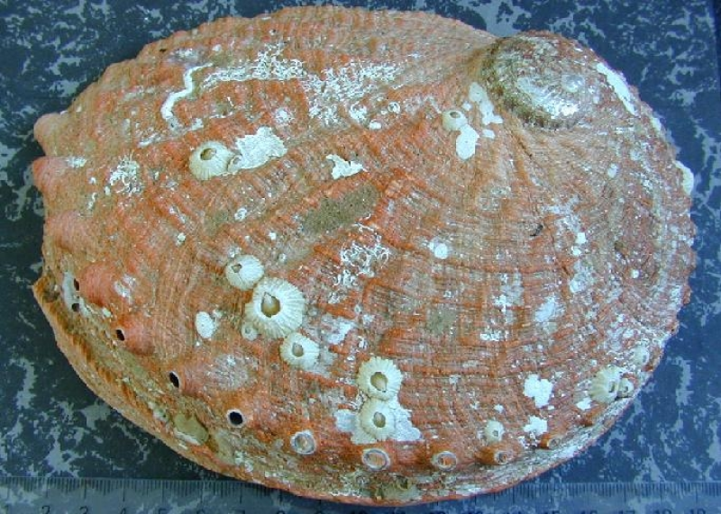
Database includes data on abalone size at maturity, collected from sites around Tasmania from 1988.
-

Seagrass beds are a dominant marine ecosystem of Tayaritja (the Furneaux Group of Islands) in the north-eastern waters off Tasmania. Historical coarse mapping has indicated extensive beds of Posidonia, Amphibolis, Heterozostera, and Zostera species, potentially comprising some of the largest and deepest seagrass extents found in temperate Australian waters. However, limited data on the distribution and ecological value of these seagrass habitats represents a significant knowledge gap in understanding Australia's wetland natural assets. This project mapped the extent, ecological composition, population structure, and blue carbon value of seagrass beds around Tayaritja, in partnership with the Tasmanian Aboriginal Centre. This record specifically describes the collection and analysis of epiphyte and mollusc communities associated with seagrass beds. Quadrat-level sampling of seagrass, epiphyte and mollusc community data was undertaken across five subtidal sites in Tayaritja Sea Country in February 2024. At each site, seagrass species, morphology, biomass and cover; epiphyte cover; and mollusc taxon counts, richness, abundance, and diversity metrics were assessed. The dataset provides a baseline for understanding biodiversity values associated with different seagrass species and epiphyte loads in Tayaritja Sea Country. See the "Lineage" section of this record for full methodology. ***EMBARGO NOTE*** Data is currently embargoed until 31/12/2026. Please contact the NESP Data Wrangler (Southern node) to discuss access options: Emma.Flukes@utas.edu.au
-

[This data has been superseded by a synthesised global dataset which includes additional ecological data contributed by non-RLS entities (National Reef Monitoring Network). Please visit the corresponding NRMN Collection (IMOS - National Reef Monitoring Network Sub-Facility - Global cryptobenthic fish abundance) for the most current version of this data. See "Downloads and Links" section below.] Reef Life Survey is designed to develop and resource a network of skilled recreational divers for rapid and cost-effective assessment of the state of the inshore marine environment at the global scale. The project uses standardised underwater visual census methods employed by trained SCUBA divers to survey fish and invertebrate species and to record habitat type using photo quadrats - this dataset refers to the cryptic fish and invertebrate survey component only. This data has been superseded by the NRM collection "IMOS - National Reef Monitoring Network - Global cryptobenthic fish abundance": see https://catalogue-imos.aodn.org.au/geonetwork/srv/eng/catalog.search#/metadata/9efa25cd-4da4-47b5-9385-45e3cbd11705
-
Recreational abalone fishing data for the periods between 2002/03 to 2024/25 for eight assessment areas in Tasmania. The data includes estimated catch (in kilograms and numbers of abalone), estimated effort (in fishing days) and estimated catch rate (in number of abalone/fishing days). Both species, blacklip abalone (Haliotis rubra) and greenlip abalone (Haliotis laevigata) are targeted by the recreational fishers. The data was compiled from the Tasmanian Recreational Rock Lobster and Abalone Fisheries survey reports produced by IMAS. The assessments are conducted using a survey involving a random sample of licence-holders who are contacted by telephone prior to the start of the fishing season and invited to participate in a phone-diary survey to monitor their abalone fishing activity between November and April.
-

[This data has been superseded by a synthesised global dataset which includes additional ecological data contributed by non-RLS entities (National Reef Monitoring Network). Please visit the corresponding NRMN Collection (IMOS - National Reef Monitoring Network Sub-Facility - Global mobile macroinvertebrate abundance) for the most current version of this data. See "Downloads and Links" section below.] Reef Life Survey is designed to develop and resource a network of skilled recreational divers for rapid and cost-effective assessment of the state of the inshore marine environment at the global scale. The project uses standardised underwater visual census methods employed by trained SCUBA divers to survey fish and invertebrate species and to record habitat type using photo quadrats - this dataset refers to the cryptic fish and invertebrate survey component only. This data has been superseded by the NRM collection "IMOS - National Reef Monitoring Network - Global mobile macroinvertebrate abundance": see https://catalogue-imos.aodn.org.au/geonetwork/srv/eng/catalog.search#/metadata/48cf3cb9-caa9-4633-9baa-8bba3c4d904a
-
The effect of barrens formed by the long spined sea urchin, Centrostephanus rodgersii, on the standing stocks of southern rock lobsters (Jasus edwardsii) and black lip abalone (Haliotis rubra) was estimated by divers using underwater visual census methods to compare lobster and abalone abundance in barrens with that in adjacent kelp habitat. Abalone (H. rubra) and rock-lobster (J. edwardsii) populations were compared on C. rodgersii barrens and in adjacent algal-dominated habitat at the same depth and on the same substratum type at three sites in eastern Tasmania (Elephant Rock:Binalong Bay, St Helens Is, and Mistaken Cape:Maria Island). At Elephant Rock and St Helens Island , the barrens are extensive and well established Type 1 barrens, while at Mistaken Cape the barrens in 8-14 m are incipient Type 4 barrens, comprising small barren patches in the algal bed (see FRDC report for classification of barren types). Note that while there are extensive barrens in deeper water (>18 m) at Mistaken Cape, at these depths working time is limited and it was difficult to locate intact macroalgal beds on equivalent substrata.