 IMAS Metadata Catalogue
EARTH SCIENCE | OCEANS
Type of resources
Topics
Keywords
Contact for the resource
Provided by
Years
-
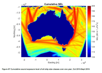
***NOTE THIS RECORD HAS BEEN SUPERSEDED BY NESP PROJECT E2 (details below)*** Cumulative Sound Exposure Levels of shipping traffic in Australian waters was undertaken over a one year period (Sept. 2015 to Oct 2016) within the Australian Exclusive Economic Zone. A proof of concept cumulative ship noise map was developed around Australia using the Perth Canyon source spectra as the source level for different vessel type categories. Sound propagation models were then run cumulatively, integrating the time spent by ships within a grid cell over the one-year period. This record describes the proof of concept map of commercial shipping noise in Australian waters developed under NESP Project C5. Refer to final report (https://www.nespmarine.edu.au/document/quantification-risk-shipping-large-marine-fauna-across-australia-final-report) for full methodology and PDF map. The ship noise modelling demonstrated the potential for using simple and readily accessible transmission models to provide an accurate representation of shipping noise within the marine soundscape. A subsequent high resolution sound exposure map was generated under NESP Project E2. See https://catalogue.aodn.org.au/geonetwork/srv/en/metadata.show?uuid=480847b4-b692-4112-89ff-0dcef75e3b84
-
The goal of our study was to split the Australian maritime Exclusive Economic Zone (EEZ) into a set of smaller acoustic zones, whereby each zone is characterised by a set of environmental parameters that vary more across than within zones. The environmental parameters chosen reflect the hydroacoustic (e.g., water column sound speed profile), geoacoustic (e.g., sound speeds and absorption coefficients for compressional and shear waves), and bathymetric (i.e., seafloor depth and slope) parameters that directly affect the way in which sound propagates. Mean zone parameters and shape files are available for download. The zones may be used to map, for example, underwater sound from commercial shipping within the entire Australian EEZ.
-

This metadata record provides a brief overview of the National Environmental Science Program (NESP) Marine Biodiversity (MB) Hub. The record acts as an aggregation point for all NESP Marine Biodiversity Hub data collections and projects developed as part of this research program. The National Environmental Science Program (NESP) is a $142.5 million initiative of the federal government providing a long-term commitment to environment and climate research. The programme builds on its predecessors – the National Environmental Research Program (NERP) and the Australian Climate Change Science Programme (ACCSP) – to support decision-makers to understand, manage and conserve Australia’s environment by funding world-class biodiversity and climate science. The NESP funding program runs from July 2015 to June 2021 and provides funding for six research hubs. The Marine Biodiversity Hub is a collaborative partnership supported by funding from the Australian Government administered by the Department of the Environment's National Environmental Research Programme. The Marine Biodiversity Hub is comprised of scientists from 10 major research institutions undertaking research of Australian oceans and marine environments, including temperate coastal water quality and marine species. The Marine Biodiversity Hub is administered by the University of Tasmania, and led by Professor Nic Bax. The 4 themes of the Marine Biodiversity Hub under the NESP program include: A. Improving the management of threatened and migratory species B. Supporting management decision making C. Understanding pressures on the marine environment D. Understanding biophysical, economic and social aspects of the marine environment Research products from the NESP Marine Biodiversity Hub are available from http://nespmarine.edu.au and the Australian Ocean Data Network catalogue (http://catalogue.aodn.org.au)
-
Recordings of ship noise were analysed to build a catalogue of ship noise signatures in Australian waters, including source spectra and source levels. The data described by this record is derived from an initial set of five deployments by the Integrated Marine Observing System (IMOS) acoustic observatories.
-
This metadata record provides a brief overview of the National Environmental Science Program (NESP) Marine and Coastal (MaC) Hub. The record acts as an aggregation point for all NESP Marine and Coastal Hub data collections and projects developed as part of this research program. The National Environmental Science Program (NESP) is a long-term commitment by the Australian Government to environment and climate research. The first phase invested $145 million (2014-15 to 2020-21) into 6 research hubs. The second phase invests $149 million (2020-21 to 2026-27) into 4 new research hubs. The program builds on its predecessors – the National Environmental Research Program (NERP) and the Australian Climate Change Science Programme (ACCSP) – to support decision-makers to understand, manage and conserve Australia’s environment by funding world-class biodiversity and climate science. The Marine and Coastal Hub is a collaborative partnership supported by funding from the Australian Government administered by the Department of Agriculture, Water and the Environment. The current NESP funding program runs from 2021 to 2027. The Marine and Coastal Hub is co-administered by the University of Tasmania (UTAS), and the Reef and Rainforest Research Centre (RRRC). The Marine and Coastal Hub will deliver: • applied research to support management of Australia’s marine and coastal environments including estuaries, coast, reefs, shelf and deep-water • targeted biodiversity and taxonomy products to support efficient system monitoring • environmental monitoring systems and decision-support tools. The hub will also drive coordinated research across all 4 new hubs under NESP’s ‘protected place management’ cross-cutting mission. This research will support management of Australia’s protected places and heritage, including the national park estate and Ramsar sites in both marine and terrestrial environments. Research products from the NESP Marine and Coastal Hub are available from https://nespmarinecoastal.edu.au and the Australian Ocean Data Network catalogue (http://catalogue.aodn.org.au)
-
Secchi disk data collected by students on the RV Investigator training voyage (Transit IN2018_T01).
-
This record describes a gridded map of ocean wind noise for Australian EEZ for a typical April-September period.
-
Water samples collected on the RV Investigator Transit voyage IN2018_T01 were analysed for concentration of chlorophyll a.
-
Over the past century there have been significant global increases in anthropogenic underwater noise from a range of sources, such as commercial shipping, oil and gas exploration, recreational and military sound sources. Anthropogenic noise has been demonstrated to impact marine animals, in particular marine mammals that rely on sound for communication, foraging, and navigation. Sound exposure may impair hearing mechanisms temporarily or permanently, with impacts ranging from temporary behavioural responses and stress, to longer term habitat avoidance, hearing loss, or mortality. Commercial shipping is thought to contribute to a significant portion of the underwater noise generated by human activity, driven by marine transport network expansion, urbanization, and greater demand for natural resources. This project aimed to quantify underwater noise from ships in Australian waters, with the ultimate goal of guiding the management of noise impacts on marine fauna. This record describes a gridded map of cumulative sound exposure from shipping in the Australian EEZ for a typical April-September period.
-
Map of cumulative sound exposure from shipping in the GBR for winter 2015 (June-September).