 IMAS Metadata Catalogue
Proof of concept shipping ocean noise map of Australia [SUPERSEDED]
***NOTE THIS RECORD HAS BEEN SUPERSEDED BY NESP PROJECT E2 (details below)***
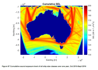
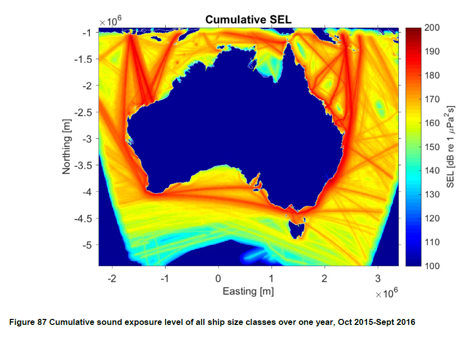
Cumulative Sound Exposure Levels of shipping traffic in Australian waters was undertaken over a one year period (Sept. 2015 to Oct 2016) within the Australian Exclusive Economic Zone. A proof of concept cumulative ship noise map was developed around Australia using the Perth Canyon source spectra as the source level for different vessel type categories. Sound propagation models were then run cumulatively, integrating the time spent by ships within a grid cell over the one-year period.
This record describes the proof of concept map of commercial shipping noise in Australian waters developed under NESP Project C5. Refer to final report ( https://www.nespmarine.edu.au/document/quantification-risk-shipping-large-marine-fauna-across-australia-final-report) for full methodology and PDF map.
The ship noise modelling demonstrated the potential for using simple and readily accessible transmission models to provide an accurate representation of shipping noise within the marine soundscape. A subsequent high resolution sound exposure map was generated under NESP Project E2. See https://catalogue.aodn.org.au/geonetwork/srv/en/metadata.show?uuid=480847b4-b692-4112-89ff-0dcef75e3b84
Simple
Identification info
- Date (Creation)
- 2018-02-13
Owner
Owner
- Credit
- National Environmental Science Program (NESP) Marine Biodiversity Hub (funding)
- Status
- Superseded
Point of contact
- Topic category
-
- Oceans
Extent
))
Temporal extent
- Time period
- 2015- 2016-10-31
- Maintenance and update frequency
- Unknown
- Keywords (Theme)
-
- Noise
- Shipping
- NASA/GCMD Keywords, Version 8.5
Resource constraints
- Other constraints
- This dataset is hosted by the Institute for Marine and Antarctic Studies (IMAS), University of Tasmania, on behalf of CSIRO and Murdoch University through the NESP Marine Biodiversity Hub Project C5.
Resource constraints
- Classification
- Unclassified
Resource constraints
- Use limitation
- Data was sourced from the NESP Marine Biodiversity Hub – the Marine Biodiversity Hub is supported through funding from the Australian Government’s National Environmental Science Program (NESP), administered by the Department of Agriculture, Water and the Environment (DAWE).
Resource constraints
- Linkage
-
http://i.creativecommons.org/l/by/4.0/88x31.png
License Graphic
- Title
- Creative Commons Attribution 4.0 International License
- Website
-
http://creativecommons.org/licenses/by/4.0/
License Text
- Other constraints
- The citation in a list of references is: citation author name/s (year metadata published), metadata title. Citation author organisation/s. File identifier and Data accessed at (add http link).
- Other constraints
- The data described in this record are the intellectual property of CSIRO and Murdoch University.
- Language
- English
- Character encoding
- UTF8
- Supplemental Information
- Peel, D., Smith, J.N., Erbe, C., Patterson, T., and Childerhouse, S. (2019). Quantification of risk from shipping to large marine fauna across Australia. Report to the National Environmental Science Program, Marine Biodiversity Hub. CSIRO https://www.nespmarine.edu.au/document/quantification-risk-shipping-large-marine-fauna-across-australia-final-report
Distribution Information
- Distribution format
-
- ESRI Shapefile
- OnLine resource
- SUPERSEDING DATA: NESP Project E2 high-resolution cumulative sound exposure from shipping in Australian EEZ
- OnLine resource
- FINAL PROJECT REPORT - Quantification of risk from shipping to large marine fauna across Australia
- OnLine resource
- NESP Marine Biodiversity Hub Project C5 webpage
Resource lineage
- Statement
- Desktop study, using vessel distribution data (AIS), vessel sound signatures, and sound propagation. See NESP C5 final report for more detail
- Hierarchy level
- Dataset
Metadata
- Metadata identifier
- urn:uuid/ec80afd1-1f1e-4c3d-82e4-8d91da825ef3
- Language
- English
- Character encoding
- UTF8
Point of contact
- Parent metadata
Type of resource
- Resource scope
- Dataset
- Metadata linkage
-
https://metadata.imas.utas.edu.au/geonetwork/srv/eng/catalog.search#/metadata/ec80afd1-1f1e-4c3d-82e4-8d91da825ef3
Point of truth URL of this metadata record
- Date info (Creation)
- 2021-03-31T08:34:11
- Date info (Revision)
- 2026-05-17T23:26:51
Metadata standard
- Title
- ISO 19115-3:2018
Overviews
Spatial extent
Provided by
