 IMAS Metadata Catalogue
CARBON
Type of resources
Topics
Keywords
Contact for the resource
Provided by
Years
-
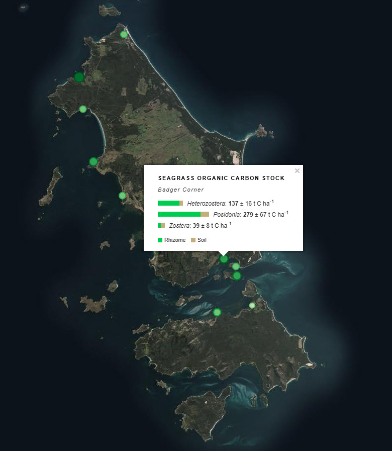
Seagrass beds are a dominant marine ecosystem of Tayaritja (the Furneaux Group of Islands) in the north-eastern waters off Tasmania. Historical coarse mapping has indicated extensive beds of Posidonia, Amphibolis, Heterozostera, and Zostera species, potentially comprising some of the largest and deepest seagrass extents found in temperate Australian waters. However, limited data on the distribution and ecological value of these seagrass habitats represents a significant knowledge gap in understanding Australia's wetland natural assets. This project mapped the extent, ecological composition, population structure, and blue carbon value of seagrass beds around Tayaritja, in partnership with the Tasmanian Aboriginal Centre. This record specifically describes the seagrass-associated blue carbon component of the project, supporting improved understanding of sedimentary carbon storage in the region. Sediment cores were collected from ten seagrass habitat sites around Flinders Island to assess spatial variability in carbon stocks and differences among seagrass species. Cores were collected to a maximum depth of 50 cm, or to the boundary between sediment and underlying rock, and were processed to estimate organic carbon stocks in below-ground sediment and plant material. The dataset includes sampling site locations, carbon stock estimates for the upper 50 cm of sediment, and measurements reported by depth interval within the core. At selected sites, samples were sieved to separate roots/rhizomes from the soil fraction, allowing carbon components to be reported separately where available. See the "Lineage" section of this record for full methodology. ***EMBARGO NOTE*** Data is currently embargoed until 31/12/2026. Please contact the NESP Data Wrangler (Southern node) to discuss access options: Emma.Flukes@utas.edu.au
-
At the inception of our project, no study had examined particle fluxes in the Subantarctic Zone (SAZ) of the Southern Ocean, despite the fact that the SAZ represents a large portion of the total area of the Southern Ocean, serve as a strong sink for atmospheric (~1G t C yr-1 [Metzl et al., 1999]), and is central to hypotheses linking particle fluxes and climate change [Francois et al., 1997; Kumar et al., 1995; Sigman et al., 1999]. The SAZ serves as an interface between the cold nutrient-rich waters to its south and the nutrient-depleted subtropical gyres to its north. SAZ upper layers are marked by a thick layer of relatively homogenous Subantarctic Mode Water (SAMW), which overlies Antarctic Intermediate Water (AAIW). Both water masses are subducted northward beneath the subtropical gyres. Thus particles leaving the surface in these regions contribute to carbon redistribution via both the fraction that reaches the deep sea by settling and the fraction that is remineralized within SAMW or AAIW and subsequently subducted. The SAZ exhibits surface water carbon dioxide partial pressures well below atmospheric equilibrium, but PFZ waters are closer to atmospheric equilibrium in this sector [Metal et al., 1999; Poppet al., 1999]. The relative physical and biological contributions to these carbon dioxide partial pressure variations are unclear, but it is important to determine them because physical and biological carbon dioxide transfers are expected to show different responses to climate change [ Matear et al., 1999; Sarmiento and LeQuere, 1996]. For these reasons we focused on the SAZ and, for comparative purposes, on the PFZ to its south. We measured particle fluxes using moored sinking particle traps at three sites in the SAZ, in the PFZ, and beneath the Subantarctic Front (SAF), which separates them. This record describes particle flux data collected between 2000 and 2001. The NetCDF data contains the following variables. Please note not all variables are supplied in all files, specifically there are not uncertainty estimates and no quality control flags for this data.
-
At the inception of our project, no study had examined particle fluxes in the Subantarctic Zone (SAZ) of the Southern Ocean, despite the fact that the SAZ represents a large portion of the total area of the Southern Ocean, serve as a strong sink for atmospheric (~1G t C yr-1 [Metzl et al., 1999]), and is central to hypotheses linking particle fluxes and climate change [Francois et al., 1997; Kumar et al., 1995; Sigman et al., 1999]. The SAZ serves as an interface between the cold nutrient-rich waters to its south and the nutrient-depleted subtropical gyres to its north. SAZ upper layers are marked by a thick layer of relatively homogenous Subantarctic Mode Water (SAMW), which overlies Antarctic Intermediate Water (AAIW). Both water masses are subducted northward beneath the subtropical gyres. Thus particles leaving the surface in these regions contribute to carbon redistribution via both the fraction that reaches the deep sea by settling and the fraction that is remineralized within SAMW or AAIW and subsequently subducted. The SAZ exhibits surface water carbon dioxide partial pressures well below atmospheric equilibrium, but PFZ waters are closer to atmospheric equilibrium in this sector [Metal et al., 1999; Poppet al., 1999]. The relative physical and biological contributions to these carbon dioxide partial pressure variations are unclear, but it is important to determine them because physical and biological carbon dioxide transfers are expected to show different responses to climate change [ Matear et al., 1999; Sarmiento and LeQuere, 1996]. For these reasons we focused on the SAZ and, for comparative purposes, on the PFZ to its south. We measured particle fluxes using moored sinking particle traps at three sites in the SAZ, in the PFZ, and beneath the Subantarctic Front (SAF), which separates them. This record describes particle flux data collected between 2004 and 2005. The NetCDF data contains the following variables. Please note not all variables are supplied in all files, specifically there are not uncertainty estimates and no quality control flags for this data.
-
This record presents data used in the paper 'Controls on polar Southern Ocean deep chlorophyll maxima: viewpoints from multiple observational platforms,' Philip W Boyd 𝘦𝘵. 𝘢𝘭., submitted to Global Biogeochemical Cycles, November 2023. All methods for the following datasets are detailed and cross-referenced in the paper. Data were collected from a range of methods, including: • vertical profiles (from 1 m resolved profiling using sensors on a CTD rosette: temperature, salinity, chlorophyll fluorescence, transmissivity - all calibrated) • vertical profiles (from discrete samples collected from CTD rosette or trace metal clean rosette, for nutrients, chlorophyll, POC, dissolved and particulate iron, active fluorescence, net primary productivity, biological iron uptake) • tow-body sections (undulating tow body (Triaxus) for temperature, salinity, chlorophyll fluorescence, transmissivity (and the ratio of chlorophyll fluorescence, transmissivity) • time-series observations from a robotic profiling float (BGC-ARGO) for temperature, salinity, chlorophyll fluorescence, and transmissivity).
-
Whale muscle samples were collected from stranded and dead blue (Baleoptera musculus) and fin (Baleoptera physalus) whales in South-western Australia. Blue, fin, sperm (Physeter macrocephalus), humpback (Megaptera novaeangliae) and pygmy blue (Baleoptera musculus brevicauda) whale faecal samples were collected from coastal waters off Southern Australia by trawling 0.5 mm mesh nets over the surface waters following defecation. Four species of krill (Nyctiphanes australia, Euphausia pacifica, Meganyctiphanes norvegica), including Antarctic krill (Euphausia superba) were collected from various locations worldwide. We analysed the concentration of iron, cadmium, manganese, cobalt, copper, zinc, phosphorus and carbon in baleen whale faeces and muscle, and krill tissue using inductively coupled plasma mass spectrometry.